
Severe Weather Outlook Later Tonight Read More >
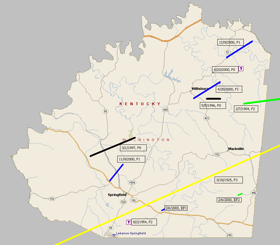
February 7, 1904
Counties: Washington, Mercer
F-scale: F2
Deaths: 0
Injuries: 11
Path width:
Path length: 15 miles
Time: 3:00am
Narrative: Moved east from ten miles west of Harrodsburg. The worst damage was at Cornishville, where seven homes, a church, and a bridge were destroyed. Other barns and homes were unroofed.
March 18, 1925
Counties: Marion, Washington KY, Mercer, Jessamine, Fayette, Bourbon
F-scale: F3
Deaths: 2
Injuries: 40
Path width: 300 yards
Path length: 60 miles (skipping)
Time: 6:30pm
Notes: What was almost certainly a family of tornadoes moved northeast from western Marion County (according to Grazulis) to 4 miles southwest of Paris in Bourbon County. This project has so far been unable to find any damage in Marion or Jessamine Counties. In Washington County many buildings across the county were leveled. The country home of Judge Case near Springfield was unroofed. The "Negro section" of Jimtown was destroyed, and all 25 houses in Jimtown were razed after the storm. In Springfield 30 people were injured and 2 were killed (the two fatalities may have been from Jimtown). Moving into Mercer County, two barns were lost on the Bond Farm. A barn was damaged and a house unroofed on the Terhune Farm, barns were blown down on the Quartz and Shelton Farms, a house and a barn were lost on the Sanford Farm, and the home of Kye Crossfield at Ebenezer was destroyed. The tornado was 1/4 mile wide in Mercer County. After possibly weakening or lifting in Jessamine County, the tornado slammed into eastern sections of Fayette County with renewed vigor. Trees were blown down on Chilesburg Road, and many trees and fences were torn down on the John E. Madden Farm on Winchester Road about four miles out of Lexington (roughly where Winchester Road meets I-75 today). The tornado reached its peak strength, high-end F3 (possibly F4) over a four-mile stretch of eastern Fayette County. About five and a half miles from Lexington on Briar Hill Road the twister devastated the Kelley Farm. Mrs. Kelley's 40-year-old "Negro hired hand" was blown 300 yards to his death. Nearly every bone in his body was broken. His right hip was dislocated to the point where it was alongside his chest. No trace of his cabin was ever found. The two-story eight-room main residence was "torn from its foundations" and reduced to a pile of rubble. The farm's chickens were stripped of their feathers. According to witnesses, the tornado was "cone-shaped and had a large black cloud at its top, coming out of the west. A pillar of flame shot skyward when the vortex of the twister struck the Kelley residence." Trees and telephone poles were blown down for a mile along Briar Hill Road. The Jonas Weil Farm on Briar Hill Road suffered an unroofed home, two miles of destroyed fence, and 500 felled trees. Moving along to the northeast, the Muir area was next in line (near the intersection of KY 1970 and KY 1973 today). William Johnson's residence on Muir Pike was "piled upon its foundations and partly blown away." The Deaver Farm was damaged, and a 15 pound rock was blown through a wall like a cannonball. Many trees were blown down. Proceeding into Bourbon County, the house of Rodes Donald had two rooms blown away, the Dudley School was moved four feet off its foundation, fifty trees were blown down on the Ewing Farm, and the Spears Farm on Stewart Road was damaged. The tornado then finally began to weaken and it dissipated about four miles shy of Paris.
August 2, 1954
Counties: Washington KY
F-scale: F2
Deaths: 0
Injuries: 0
Path width:
Path length:
Time: 3:00pm
Grazulis Narrative: Three barns and a small school were destroyed two miles south of Springfield. One home was unroofed.
Noted discrepancies: SPC and Storm Data list both Taylor and Washington counties...NCDC lists only Taylor County...Grazulis lists only Washington County. SPC's and Storm Data's "Taylor and Washington" counties makes no sense since those two counties don't border each other. SPC/NCDC's lat/lon pairs start this tornado in Taylor County and end it in Washington County, crossing the entire width of Marion County in between. SPC and NCDC give a path length of 15 miles, Grazulis and Storm Data give 1 1/2 miles. SPC gives a path width of 10 yards...NCDC 30 yards...Grazulis and Storm Data 100 yards. Apparently the only tornado damage Grazulis could find with this event was two miles south of Springfield near the Washington/Marion County line (which is where SPC and NCDC have the tornado track's end point). Storm Data narrative says, "Tornado first appeared near Finley in Taylor County, completely missed Marion County, and came to earth again in Washington County a short distance south of Springfield." The distance across Marion County is about 14 miles. Thus, it seems this should be plotted as two separate tornadoes...with one in Taylor County near Finely and the other in Washington County near Springfield. However, before plotting the Taylor County tornado, an F-scale must be investigated.
May 5, 1996
Counties: Washington KY
F-scale: F0
Deaths:
Injuries:
Path width:
Path length:
Time: 12:35pm
Notes: Storm Data says this tornado touched down a mile east of Willisburg.
March 1, 1997
Counties: Washington KY
F-scale: F0
Deaths:
Injuries:
Path width:
Path length:
Time: 11:59am
Noted discrepancies: Storm Data puts this tornado on Lincoln Park Road.
April 20, 2000
Counties: Washington KY
F-scale: F1
Deaths:
Injuries: 4
Path width:
Path length:
Time: 4:55pm
Noted discrepancies: SPC lists a path width of 70 yards, NCDC 73 yards, Storm Data 50 yards.
Notes: Storm Data takes this tornado from half a mile north of Willisburg to two miles northeast of Willisburg.
April 20, 2000
Counties: Washington KY
F-scale: F0
Deaths: 0
Injuries: 0
Path width: 40 yards
Path length: 1/3 of a mile
Time: 5:00pm
Noted discrepancies: This tornado is not listed at SPC or NCDC, but is in Storm Data. Storm Data lists this tornado in Mercer County, but it takes this storm from 4.3 miles southwest of Dugansville to 4 miles southwest of Dugansville near Tablow. This distance from Dugansville would put it in Washington County. Tablow is directly on the county line. Will plot it in Washington County.
November 9, 2000
Counties: Washington, KY
F-scale: F1
Deaths:
Injuries:
Path width:
Path length:
Time: 1:55pm
Noted discrepancies: SPC lists a path width of 70 yards, NCDC 73 yards, Storm Data 75 yards.
Notes: Storm Data takes this tornado from half a mile south of Saint Catherine to one and a half miles northeast of Saint Catherine.
November 9, 2000
Counties: Washington KY
F-scale: F1
Deaths:
Injuries: 1
Path width:
Path length:
Time: 2:10pm
Noted discrepancies: SPC lists a path width of 70 yards, NCDC 73 yards, Storm Data 75 yards.
Notes: Storm Data takes this tornado from half a mile northeast of Sharpsville to two miles northeast of Sharpsville.
February 6, 2008
Counties: Washington KY
EF-scale: EF1
Deaths: 0
Injuries: 0
Path width: 150 yards
Path length: 0.3 miles
Time: 1:01am EST to 1:03am EST
Notes: Touchdown was on Pleasant Drive about two miles southeast of Springfield. The tornado blew the roof off of a house and threw it about 125 yards downwind. Several pine trees were snapped and small outbuildings were destroyed. A 14" diameter pine tree was snapped and moved about 45 yards downwind as well.
February 6, 2008
Counties: Washington KY
EF-scale: EF2
Deaths: 0
Injuries: 0
Path width: 250 yards
Path length: 1 mile
Time: 1:06am EST to 1:08am EST
Notes: Touchdown was on Russell Lane about 8 miles east northeast of Springfield. The tornado completely blew away a large, well constructed outbuilding. Six-by-six inch posts were snapped and piled up, while metal sheeting was blown about a quarter of a mile away. Concrete joists weighing two hundred pounds were displaced.


 Weather Story
 Weather Map
 Local Radar
 Follow us on YouTube