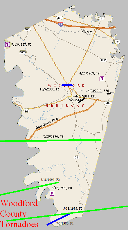
April 21, 1963
Counties: Woodford
F-scale: F2
Deaths: 0
Injuries: 3
Path width: 200 yards
Path length: 2 miles
Time: 10:50pm
Grazulis narrative: Moved northeast from northeast of Versailles. Fourteen farm buildings were damaged and a tenant home was destroyed. (Storm Data says this tornado struck three and a half miles northeast of Versailles at Maplewood Farm.)
Noted discrepancies: None.
July 2, 1980
Counties: Mercer, Woodford
F-scale: F1
Deaths:
Injuries: 1
Path width:
Path length:
Time: 7:30pm
Noted discrepancies: Storm Data also includes Jessamine County, but mentions no specific damage.
July 13, 1987
Counties: Woodford
F-scale: F0
Deaths:
Injuries:
Path width:
Path length:
Time: 1:30pm
Notes: Storm Data says this tornado hit the Buckley Wildlife Refuge.
June 18, 1992
Counties: Woodford
F-scale: F0
Deaths:
Injuries:
Path width:
Path length:
Time: 5:22pm
Noted discrepancies: SPC gives a time of 5:22pm, NCDC gives 4:22pm, Storm Data gives 6:22pm.
Notes: Storm Data says this tornado struck near Troy.
May 18, 1995
Counties: Mercer, Woodford
F-scale: F2
Deaths: 0
Injuries: 8
Path width: 125 yards
Path length: 10 miles
Time: 7:16am-7:28am EDT
Notes from investigation in 2017: Several homes were damaged and trees uprooted as the tornado touched down. On the north side of Salvisa there was roof damage to barns and sheds along with extensive tree damage. On US 127 cars were blown off the road and damaged. Trees and power poles were snapped between Oregon and Ebenezer. Tree damage occurred near Nonesuch with F1 strength winds in southern Woodford County.
Noted discrepancies: SPC and NCDC list this as an F2, but Grazulis does not list it (which it should be, regardless of strength, as was his practice in his 1992-1995 supplement...lending support to the theory that this tornado is listed in Grazulis as the Woodford County event.) The lat/lon given for this tornado agrees with the location Grazulis gives: Salvisa, which is in Mercer County, not Woodford. Storm Data mentions the tornado location as Salvisa, but lists it under Woodford County, at 7:45am, with 6 injuries.
May 18, 1995
Counties: Mercer, Woodford, Jessamine, Fayette
F-scale: F2
Deaths: 0
Injuries: 30
Path width: 350 yards
Path length: 24 miles
Time: 7:19am-7:46am EDT
Notes from investigation in 2017: In McAfee several homes had uplifted roofs, a chimney was destroyed, and garage doors collapsed. Barns and outbuildings were destroyed. Several cars were blown off US 127, resulting in injuries. The tornado crossed into southern Woodford County just north of Mundys Landing. It damaged or destroyed eight homes with several injuries. In southwest Jessamine County at the intersection of KY 1268 and US 68 seven horses were killed along with extensive barn and fence damage. West Jessamine High School was hit around 7:36am when the tornadic wind speeds were around 145mph. Extensive structural damage was done to the school, amounting to a cost of two million dollars. There were at least 20 injuries, one critical. The tornado struck as students were arriving at school on buses. Eleven buses suffered damage and had their windows blown out. The high school roof was lifted and some top floor exterior walls collapsed. The school's tobacco barn and greenhouse were destroyed and the cattle barn was damaged. The tornado then hit a strip mall and Wal-Mart producing roof uplift and sign damage. Numerous pallets loaded with mulch and topsoil were thrown or shifted several yards. Across the county numerous power poles, barns, and homes sustained damage. The tornado weakened to F1 strength as it moved into the Tates Creek Trailer Park on the Fayette County line. There was complete destruction of roofs and walls of several single and double wide trailers. As the tornado lifted at Coletown several trees fell or were snapped.
Grazulis narrative: A tornado touched down near US 127 and moved northeast. Three houses were destroyed and five were damaged. Barns were blown down along KY 1160 near McAfee. There were also two cars damaged and eight minor injuries. A car was tossed several hundred yards.
Noted discrepancies: Grazulis times this at 6:35am. NCDC gives no beginning or ending locations for this tornado. SPC gives one point, just northeast of KY 390 northwest of Bohon.
May 28, 1996
Counties: Anderson, Woodford
F-scale: F2
Deaths:
Injuries: 1
Path width:
Path length:
Time: 6:10pm
Noted discrepancies: SPC has no entry for fatalities...NCDC lists zero...Storm Data lists one.
Notes: Storm Data says this tornado formed near Fox Creek, moving south of Lawrenceburg...along KY 513 near the intersection of the Blue Grass Parkway and US 127...Gilbert's Creek Road...and Lillards Ferry Road in Woodford County.
November 9, 2000
Counties: Woodford
F-scale: F1
Deaths:
Injuries:
Path width:
Path length:
Time: 2:34pm
Noted discrepancies: SPC lists a path width of 70 yards, NCDC 73 yards, Storm Data 75 yards.
Notes: Storm Data takes this tornado from one mile northwest of Versailles to one mile north of Versailles.
April 22, 2011
Counties: Woodford
EF-Scale: EF-0
Deaths: 0
Injuries: 0
Path width: 60 yards
Path length: 0.75 mile
Time: 7:07pm EDT
Notes: This tornado caused relatively minor damage to fences, trees, and a few roofs on the east side of Versailles.
April 22, 2011
Counties: Woodford
EF-Scale: EF-0
Deaths: 0
Injuries: 0
Path width: 40 yards
Path length: 0.25 mile
Time: 7:13pm EDT
Notes: This small tornado damaged trees and roofs near KY 1967 north of US 60.


 Weather Story
 Weather Map
 Local Radar
 Follow us on YouTube