This was the first tornado ever documented in the eight county Chicago metro area during the winter months of December, January, or February. (Meteorological winter is considered to be December through February. Astronomical winter is the period from winter solstice to vernal equinox, roughly December 21 through March 21.) The event had previously been noted in National Weather Service (NWS) records as thunderstorm wind damage. However, Chicago Tribune reader David Hammer of Palatine came across an old Daily Herald newspaper account of the twister and brought it to the attention of WGN meteorologist Steve Kahn. NWS personnel at the forecast office in Romeoville reviewed the article, looked at the meteorology of the event, and conferred with State Climatologist Jim Angel, and determined that a tornado did occur.
According to the newspaper article, the tornado first struck along Palatine Road, just west of Arlington Heights Road (then known as State Road), where it damaged studs of a barn under construction. The tornado moved northeast breaking windows and damaging a chimney at a house on Rand Road near State. It continued northeast through mostly open fields before it hit Buffalo Grove Road, south of Dundee Road. The storm uprooted trees, damaged a shed, and shifted the roof of a house. Another farm had a barn and a chicken coup flattened and large trees uprooted. There was damage to windows and the chimney of the farm house. Another farm on Dundee Road suffered damage to three chicken houses. Trees and power poles were also downed. Continuing northeast, the tornado damaged trees and demolished a garage at McHenry Road.
Based on the damage reported in the newspaper article, it appears the tornado was an F1 on the old Fujita scale. Winds were most likely in the range of 90 to 110 mph, which would give the tornado a rating of EF1 on the new Enhanced Fujita scale. (Visit the webpage at http://www.spc.noaa.gov/efscale/ for more information on the EF scale.) The tornado path was approximately 3 miles in length, starting 1 mile north of Arlington Heights and continuing to .5 miles east of Buffalo Grove. The tornado occurred around 745 PM, a few hours after dark, so there were no eyewitness reports of an actual tornado funnel in the article.
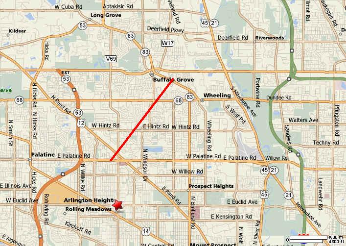
Map of tornado path
Earlier in the evening an F2 tornado struck Spring Valley in Bureau County and continued on a 25 mile path to the northeast, ending seven miles northeast of Mendota in LaSalle County.
On December 6, a deep area of low pressure moved from western Kansas to southern Minnesota. An associated warm front lifted north across the Midwest bringing a strong southerly flow of warm moist air to the region. Temperatures surged into the middle 60s in Chicago by late afternoon and dew point temperatures climbed into the 50s. The official high temperature at Chicago’s Midway Airport was a record 65 degrees (tied in 1980). A squall line developed ahead of a cold front, which swept through the area during the evening.
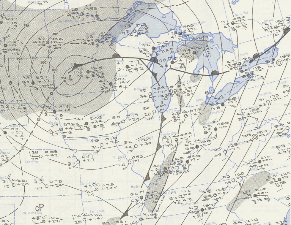
Surface weather map for 1230 AM CST December 7, 1951
The NWS’s Storm Prediction Center has tornado records dating back to 1950. Based on these records, and research done by Tom Grazulis, a tornado historian, there had never been a tornado documented in the Chicago metropolitan area in the winter months. There are only a handful of winter tornadoes in the books for all of north central and northeast Illinois, and northwest Indiana. This list is through 2008.
January 25, 1950, F2 tornado at Momence, Kankakee County
December 6, 1951, F2 tornado from Spring Valley, Bureau County to 7 miles northeast of Mendota, LaSalle County (25 mile path 1 killed, 1 injured)
December 6, 1951, F1 tornado from 1 mile north of Arlington Heights to .5 mile east of Buffalo Grove, Cook County (3 mile path)
December 3, 1955, F2 tornado from near Dana, LaSalle County to 5 miles south of Mazon, Grundy County (25 mile path, also crossed Livingston County)
December 8, 1966, F2 tornado 8 miles north of Rensselaer, Jasper County, IN (1 injured)
December 4, 1973, F1 tornado near Ashkum, Iroquois County
February 16, 2006, F1 near Pittwood, Iroquois County
January 7, 2008, EF3 Poplar Grove to Lawrence


 Follow us on YouTube