A line of thunderstorms formed during the pre-dawn hours of July 25, 2007 over southern Lake Michigan and tracked southwestward across the Chicago metropolitan area. In addition to the heavy rain and frequent lightning that the storms produced across much of the metropolitan area, they also produced a couple of localized damaging microbursts. The first microburst occurred in the Burr Ridge area, near I-55 and I-294 around 4:40 AM. The second microburst occurred in unincorporated Homer Glen in northern Will County around 5:01 AM.
A microburst occurs when a sudden rush of very heavy rain from a thunderstorm hits the ground with force, sending a surge of wind fanning out in all directions. These microburst signitures can often be detected by doppler radar, particularly when they occur close to the radar site. The microbursts that occurred in Burr Ridge and Homer Glen were both evident on the terminal doppler radar from O’hare, which is located near La Grange, IL.
Below are radar images the O’Hare terminal doppler radar of the velocity data which detected the damaging winds.
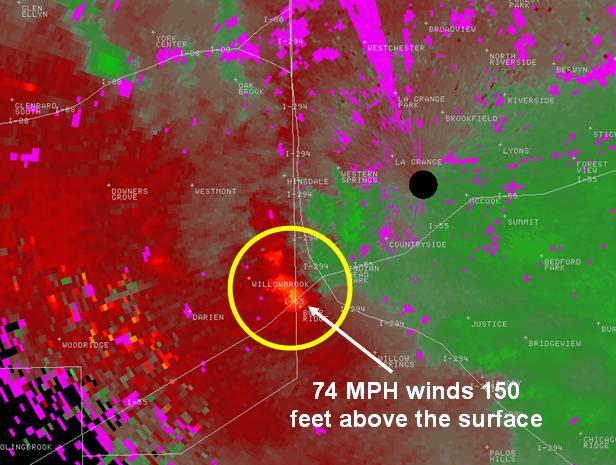
The bright orange colors in the image above indicate winds blowing at over 70 MPH just above the ground that are being detected by the O'Hare terminal doppler radar.
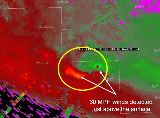
The bright orange colors in the image above indicate winds blowing at over 60 MPH just above the ground that are being detected by the O’Hare terminal doppler radar.


 Follow us on YouTube