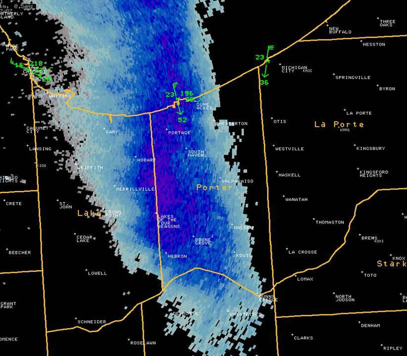
A strong cold front swept across region during the afternoon hours on February 10th with very cold air spilling into the region behind the front, ushered in by strong north winds. The very cold air moving over the unseasonably mild Lake Michigan waters proved to be an ideal set-up for the development of an intense lake effect snow band Friday evening into the wee hours of Saturday morning. The image below is a snap shot of the WSR-88D doppler radar picking up on the very intense lake effect snow band shortly after 11 PM on the 10th. The areas of dark blue and purple are where the radar was detecting extraordinarily heavy lake effect snow, with hourly accumulation rates nearing 4 inches per hour! In addition, it was at this time that the coastal weather station at Burns Harbor reported a wind gust to 52 knots (60 mph). Numerous reports indicated that the combination of the extremely heavy snow and very strong winds were producing white out conditions with visibilities less than 10 feet reported!! The band was so intense that there was even thunder and lightning reported with the snow, much like what occurred with the Groundhog Day blizzard last year.
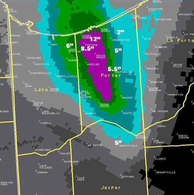
The lake effect snow band wiggled and wobbled about for several hours across Porter and eastern Lake counties, resulting in a narrow, but significant band of heavy snow totals across the area. As is often the case with lake effect snow, amounts varied greatly over very short distances. The map below is an image of doppler radar estimated snowfall amounts, with the areas in purple where the radar was estimated snowfall amounts in excess of 6 inches. Several snowfall reports from across the area confirmed that the radar's estimation of where the heaviest snow fell was dead on, with a foot of snow reported just northeast of Portage, IN and 8.5" reported in the city of Portage. Notice that just east of Chesterton only 2" of snow fell, with even lighter amounts across much of western and southern Lake county. This image below illustrates just how difficult it can be to forecast lake effect snow, with radar estimates showing the band of 6"+ snowfall amounts less than 10 miles across! What the image below doesn't show is that much of that snow fell in a matter of just a couple hours!
The map below compiled from 24-hour snowfall totals measured by COOP and Cocorahs observers also shows well the location of where the lake effect snow band was at its heaviest and most persistent last night in the forecast area. This was roughly from extreme eastern Lake County, southwest of a line from Portage to Valparaiso to Kouts in Porter County, where several reports in excess of 6" were received (largest volunteer observer report: 10" 2 miles NNE of Lake of the Four Seasons), down to northwestern Jasper County. A Cocorahs observed 3 miles south of Wheatfield in northwest Jasper measured 10" of snow. Furthermore, a COOP observer located 5 miles north of Medaryville in Pulaski County measured a snow total of 6", which was basically on the far southern end of the heavy lake effect band.
Below are Cocorahs and COOP observer reports from the event in descending order, including the lighter snows observed in northern Illinois.
...MORNING SNOWFALL ROUNDUP...

   THE FOLLOWING ARE SNOW AMOUNTS FOR THE PREVIOUS 24-HOURS.
   OBSERVATIONS ARE USUALLY TAKEN AT 7 AM.

   24-HOUR SNOWFALL AMOUNTS FOR SATURDAY(02/11/12)...

NORTHWEST INDIANA                              SNOW
  LOCATION (COUNTY):                           FALL(INCHES)

  LAKES OF THE FOUR SEASONS 2NNE (PORTER)......10.0
  WHEATFIELD 3S (JASPER).......................10.0
  VALPARAISO 6WSW (PORTER)......................9.5
  VALPARAISO 3WSW (PORTER)......................8.5
  HEBRON 4NE (PORTER)...........................7.5
  VALPARAISO 1NNW (PORTER)......................5.0
  PORTAGE 1ESE (PORTER).........................4.6
  VALPARAISO 1ENE (PORTER)......................4.6
  VALPARAISO 2N (PORTER)........................4.1
  VALPARAISO 5NNE (PORTER)......................3.9
  VALPARAISO 5NNE (PORTER)......................3.9
  VALPARAISO 2NW (PORTER).......................3.4
  PORTER 1S (PORTER)............................3.4
  CROWN POINT 2WSW (LAKE).......................1.5
  CROWN POINT 1N (LAKE).........................1.5
  REMINGTON (JASPER)............................1.3
  DYER 1WNW (LAKE)..............................1.2
  HAMMOND 3SW (LAKE)............................0.9
  RENSSELAER 6SE (JASPER).......................0.7
  ST. JOHN (LAKE)...............................0.6
  MOUNT AYR 2NNE (NEWTON).......................0.6
  DE MOTTE 6S (JASPER)..........................0.5
  DE MOTTE 1NNW (JASPER)........................0.5
  MOROCCO (NEWTON)..............................0.5
  DE MOTTE 1SSW (JASPER)........................0.3
  REMINGTON (JASPER)............................0.3
  DE MOTTE 4SW (JASPER).........................0.3
  RENSSELAER (JASPER)...........................0.2

NORTHERN ILLINOIS                              SNOW
  LOCATION (COUNTY):                           FALL(INCHES)

  BEACH PARK 1W (LAKE)..........................3.0
  BULL VALLEY 2WNW (MCHENRY)....................2.4
  WONDER LAKE 1WNW (MCHENRY)....................2.4
  BARRINGTON (LAKE).............................2.0
  CHICAGO 6ESE (COOK)...........................2.0
  HOMER GLEN 1ENE (WILL)........................2.0
  WILLOW SPRINGS (COOK).........................2.0
  SPRING GROVE 2N (MCHENRY).....................1.9
  NEW LENOX 2SE (WILL)..........................1.8
  WAUCONDA (LAKE)...............................1.8
  LA GRANGE PARK 1SSW (COOK)....................1.6
  MIDWAY 3SW (COOK).............................1.6
  OHARE (COOK)..................................1.5
  INVERNESS 2S (COOK)...........................1.4
  WOODSTOCK 5NW (MCHENRY).......................1.4
  SCHAUMBURG  2E (COOK).........................1.3
  ELK GROVE VILLAGE 2WSW (COOK).................1.3
  LINCOLNWOOD 2E (COOK).........................1.3
  LOMBARD 1NNW (DU PAGE)........................1.3
  MANHATTAN 5ENE (WILL).........................1.3
  MANHATTAN (WILL)..............................1.3
  MUNDELEIN (LAKE)..............................1.3
  OAK BROOK (DU PAGE)...........................1.3
  SCHAUMBURG 3WSW (COOK)........................1.2
  CAROL STREAM (DU PAGE)........................1.2
  ROMEOVILLE (WILL).............................1.2
  YORKVILLE 2SE (KENDALL).......................1.2
  ANTIOCH 4W (LAKE).............................1.0
  OAK PARK 2S (COOK)............................1.0
  CHICAGO RIDGE (COOK)..........................1.0
  WORTH (COOK)..................................1.0
  ORLAND HILLS 1S (COOK)........................1.0
  ELK GROVE VILLAGE 1ESE (COOK).................1.0
  BURR RIDGE 2SW (DU PAGE)......................1.0
  GENEVA 1SSW (KANE)............................1.0
  RIVERWOODS (LAKE).............................1.0
  LAKEMOOR 2SE (LAKE)...........................1.0
  LAKE ZURICH (LAKE)............................1.0
  PARK FOREST (COOK)............................1.0
  WINFIELD (DU PAGE)............................1.0
  GENOA (DE KALB)...............................0.9
  WESTMONT 1SSE (DU PAGE).......................0.9
  NAPERVILLE 3ESE (DU PAGE).....................0.9
  LISLE 1SE (DU PAGE)...........................0.9
  WAUKEGAN 2N (LAKE)............................0.9
  ROCKFORD (WINNEBAGO)..........................0.9
  PALATINE 1E (COOK)............................0.8
  ST. CHARLES (KANE)............................0.8
  LINCOLNSHIRE 1N (LAKE)........................0.8
  ALGONQUIN 1N (MCHENRY)........................0.8
  CRETE 3E (WILL)...............................0.8
  ST CHARLES (KANE).............................0.8
  COAL CITY 4NNW (GRUNDY).......................0.7
  ELGIN (KANE)..................................0.7
  ELBURN (KANE).................................0.7
  AURORA 4SE (DU PAGE)..........................0.7
  ELGIN 1S (KANE)...............................0.7
  NORTH AURORA 2NE (KANE).......................0.7
  HUNTLEY 4W (MCHENRY)..........................0.7
  PEOTONE (WILL)................................0.7
  JOLIET 2N (WILL)..............................0.7
  PLAINFIELD (WILL).............................0.7
  ST ANNE (KANKAKEE)............................0.7
  ST CHARLES 7NW (KANE).........................0.7
  WOODSTOCK 5NW (MCHENRY).......................0.7
  PAXTON (FORD).................................0.6
  SUGAR GROVE 1NE (KANE)........................0.6
  BATAVIA 1WNW (KANE)...........................0.6
  PEOTONE (WILL)................................0.6
  ROSCOE 2ESE (WINNEBAGO).......................0.6
  PEOTONE (WILL)................................0.6
  ROCKFORD 4NW (WINNEBAGO)......................0.6
  ROSCOE 2SE (WINNEBAGO)........................0.6
  BATAVIA (KANE)................................0.5
  BOURBONNAIS (KANKAKEE)........................0.5
  CHATSWORTH (LIVINGSTON).......................0.5
  DE KALB (DE KALB).............................0.5
  ELGIN (KANE)..................................0.5
  HERSCHER (KANKAKEE)...........................0.5
  HOFFMAN ESTATES 5W (COOK).....................0.5
  COUNTRYSIDE 1ENE (COOK).......................0.5
  NAPERVILLE 1NW (DU PAGE)......................0.5
  MONTGOMERY 2SSE (KENDALL).....................0.5
  OSWEGO 5SSE (KENDALL).........................0.5
  YORKVILLE 1NE (KENDALL).......................0.5
  GENEVA 2ENE (KANE)............................0.5
  BATAVIA 2WNW (KANE)...........................0.5
  ELBURN 3NNE (KANE)............................0.5
  GENEVA 2WSW (KANE)............................0.5
  OTTAWA 1NW (LA SALLE).........................0.5
  MARSEILLES 6WNW (LA SALLE)....................0.5
  CHATSWORTH (LIVINGSTON).......................0.5
  LANSING (COOK)................................0.5
  PAW PAW (LEE).................................0.5
  PONTIAC (LIVINGSTON)..........................0.5
  AURORA (KANE).................................0.4
  CORTLAND (DE KALB)............................0.4
  MONTGOMERY 1SSE (KENDALL).....................0.4
  ST. CHARLES 6NW (KANE)........................0.4
  ROCKFORD 1NW (WINNEBAGO)......................0.4
  ROCKTON 1ESE (WINNEBAGO)......................0.4
  MILFORD (IROQUOIS)............................0.4
  MENDOTA 1N (LA SALLE).........................0.3
  MENDOTA (LA SALLE)............................0.3
  OTTAWA (LA SALLE).............................0.3
  STREATOR (LIVINGSTON).........................0.3
  DRESDEN LOCK/DAM (GRUNDY).....................0.2
  DWIGHT (LIVINGSTON)...........................0.2
  PARK FOREST 1NNE (COOK).......................0.2
  AMBOY (LEE)...................................0.2
  BYRON 3N (OGLE)...............................0.2
  MARSEILLES (LA SALLE).........................0.2
  SHABBONA (DE KALB)............................0.2
  STEWARD (LEE).................................0.2
  EARLVILLE 3S (LA SALLE).......................0.1
  ASHTON (LEE)..................................0.1
  SHERIDAN 3SSE (LA SALLE)......................0.1
  OTTAWA 2N (LA SALLE)..........................0.1
  LA SALLE (LA SALLE)...........................0.1
  MARSEILLES 3NW (LA SALLE).....................0.1
  FAIRBURY (LIVINGSTON).......................TRACE
  WATSEKA 5W (IROQUOIS).......................TRACE
  SENECA 1NE (LA SALLE).......................TRACE
  PLAINFIELD 1SW (WILL).......................TRACE
  PAXTON (FORD)...............................TRACE
  ROCHELLE (OGLE).............................TRACE


 Follow us on YouTube