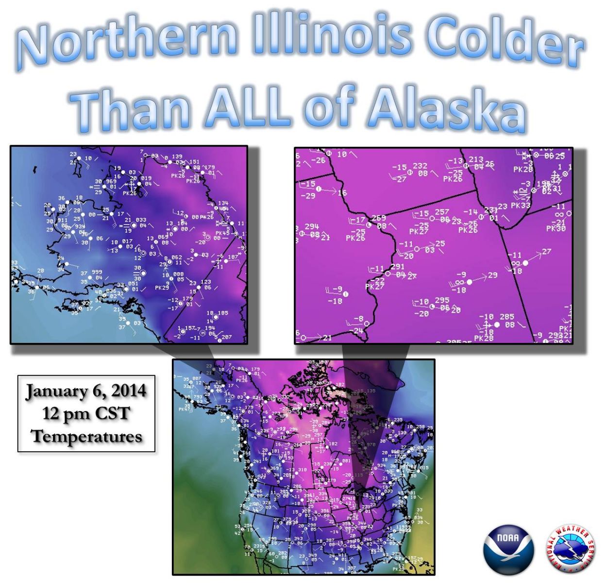
Fast Facts | Temperatures | Wind Chills | Science & Photos | More on the Cold Air
Chicago
Rockford
Areawide
|
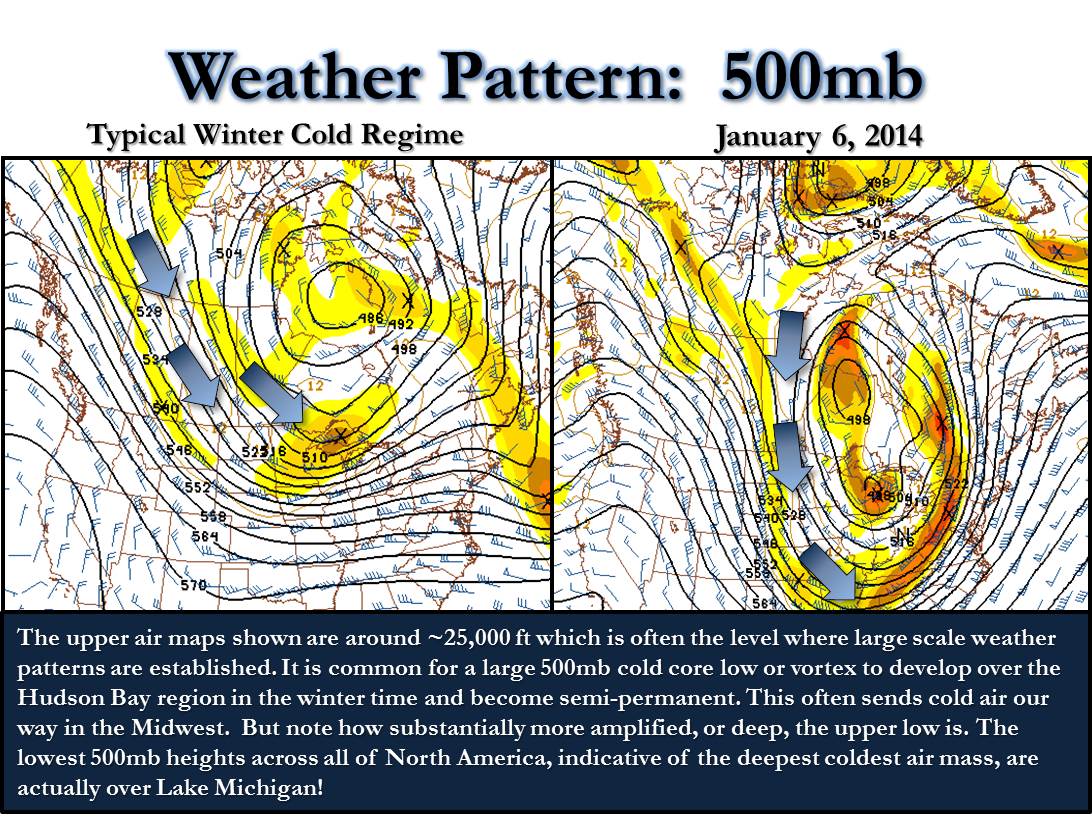
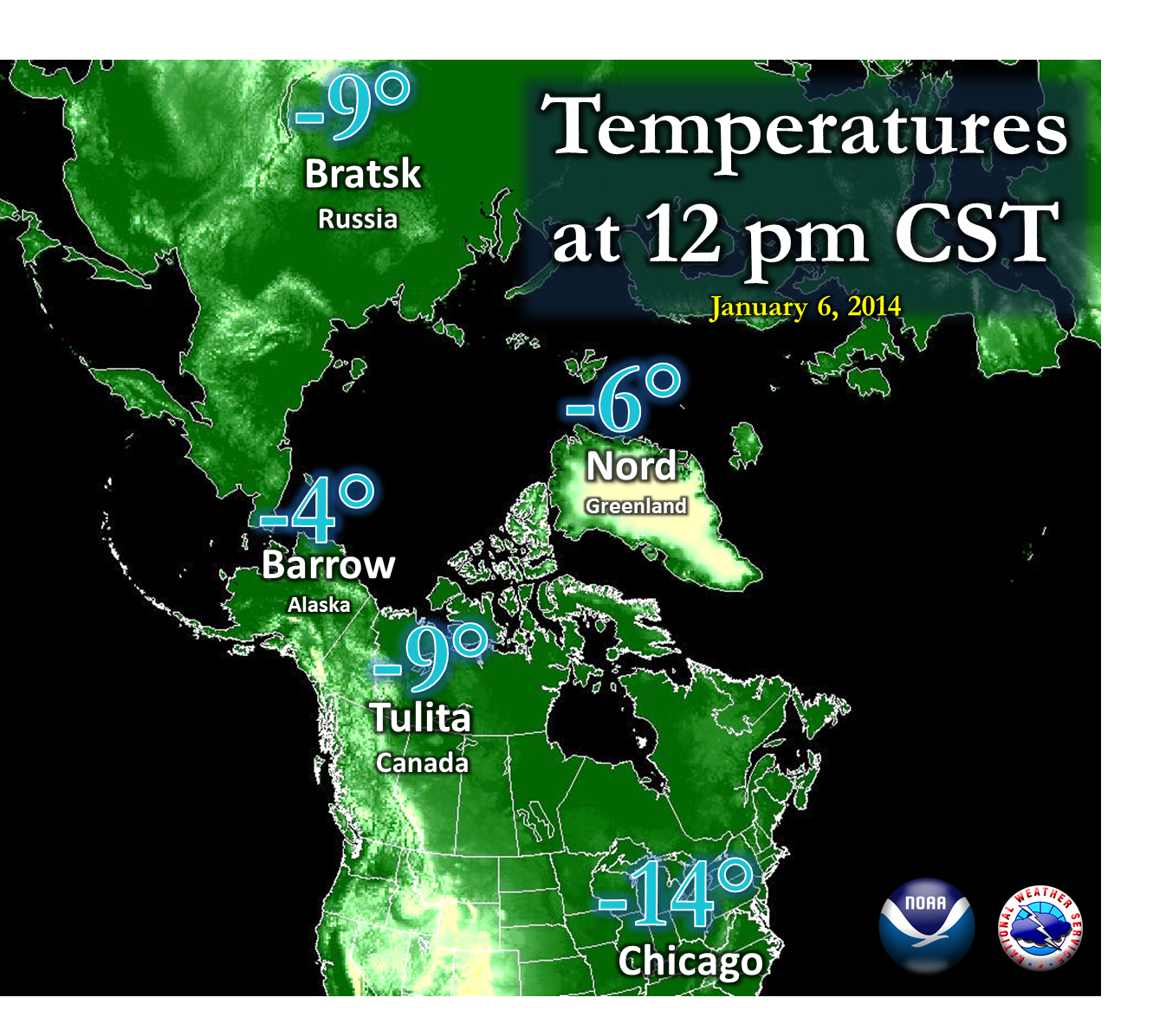
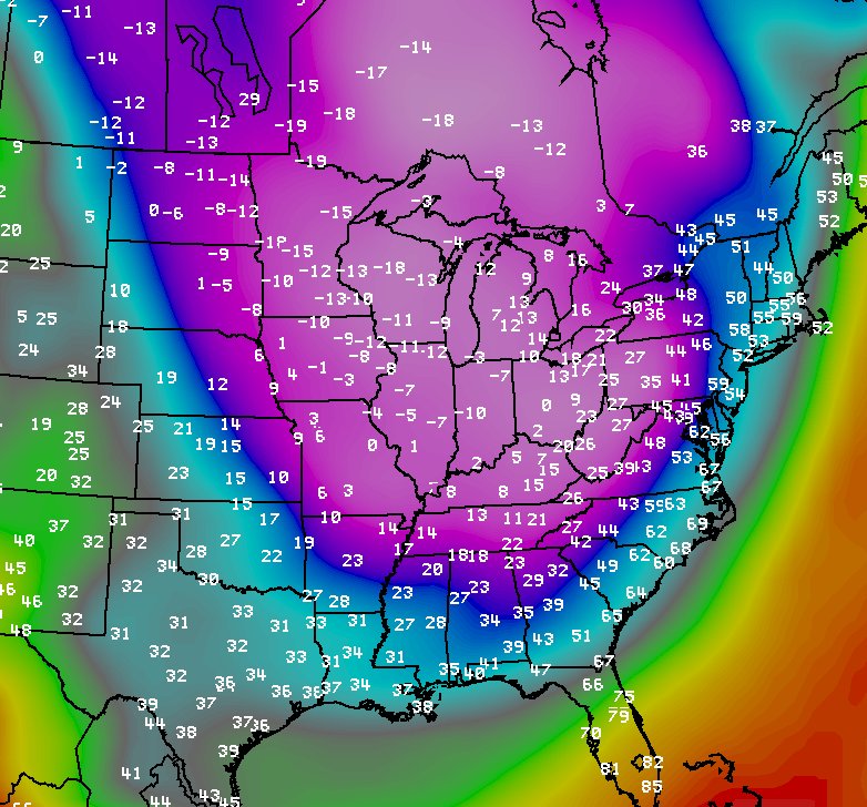
The extremely cold air centered on January 6th was caused by several factors. Successive cold fronts throughout the latter part of December into January helped usher the cold air into the region. There was little in the way of modification, besides a brief warm stint on Dec 28th. Each cold front further established the cold air's presence, if not directly over the region, at least "upstream" of the region across southern Canada. This enabled the winter storm of Jan 4-5th to tap very cold air and wrap it southward into the area as it deepened across the Ohio River Valley. This system also was responsible for the strong winds on its back side, which led to low winds chills and blowing snow long after the initial onset of the arctic chill. On the larger scale, a potent jet stream that had been in place for several weeks evolved into a large "buckle" over central North America by Jan 6th. This is known as a trough to meteorologists, and the one that evolved with our cold air outbreak was particularly deep and cold. The depth of the cold air dictated the air mass and fronts at the surface. More on this can be seen below. |
|
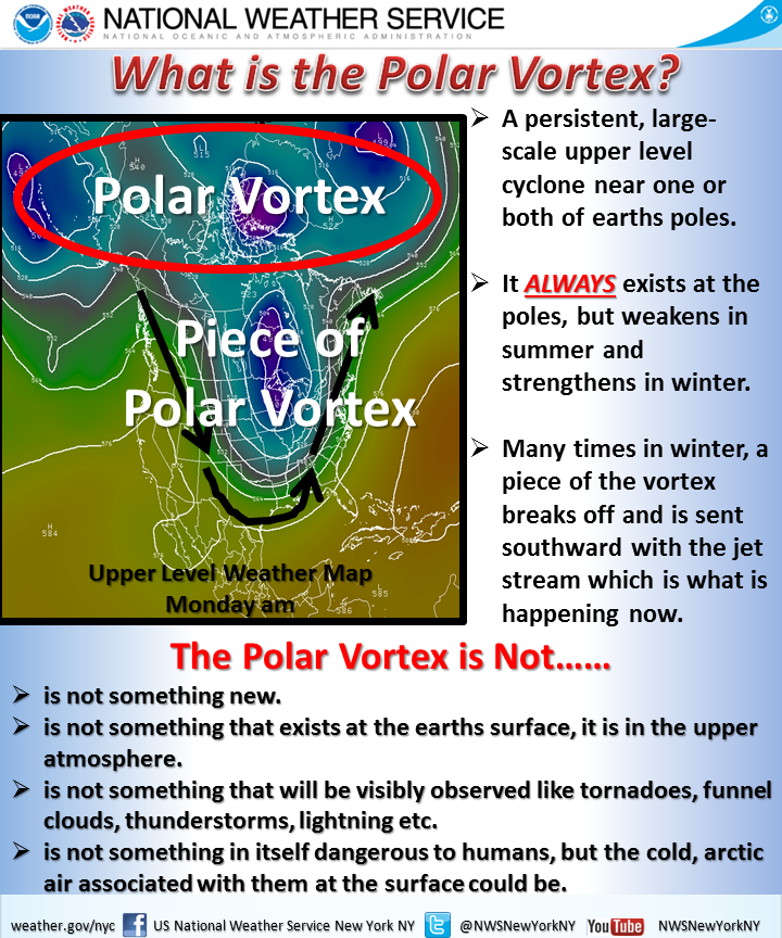 |
| The upper air pattern related to a section of the polar vortex, which became a viral term during this cold air outbreak. For more on this, please see this helpful graphic from our colleagues at the New York NWS office. |
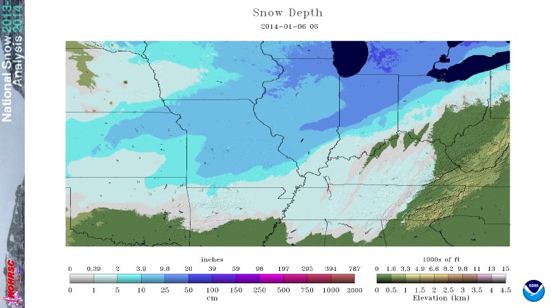
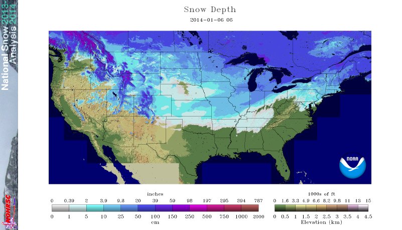
One final factor that helped was snow cover, which we had plenty of over the region due to two consecutive winter storms over New Year's and Jan 4-5th. Snow cover serves as almost a "freezer", preserving the cold air mass as it works southward. During the daytime, it also reflects much of the sun's short wave energy, not allowing for as much heating. Below one can see the substantial amount and depth of snow cover on Jan 6th, not only over the immediate area but "upstream" for northwest winds.
|
January 6th Regional Snow Depth |
|
|
|
January 6th National Snow Depth |
|
|
|
Images courtesy of the National Operational Hydrologic Remote Sensing Center |
|
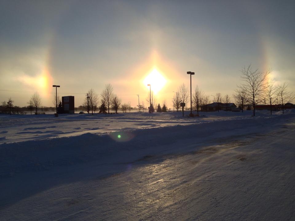
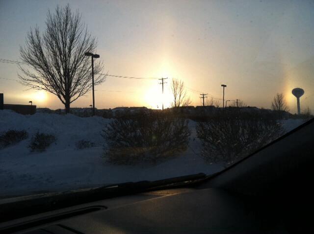
Sundogs |
||
|
Sugar Grove |
Plainfield |
Joliet |
 |
|
|
|
Sundogs are a pair of brightly colored spots on the circumference of the sun halo, often located directly apart from each other. They form as a result of sunlight being refracted by ice crystals. These are most commonly caused by cirrus clouds which are composed of ice crystals. However, crystals were present in the lower atmosphere on January 6th due to both blowing snow as well as light cloud development. Because the lower atmosphere was so cold these lower clouds were composed of ice crystals. This led to frequent sundogs across northern Illinois and northwest Indiana on January 6th! We thank our NWS Chicago Facebook fans for the photos. |
||
|
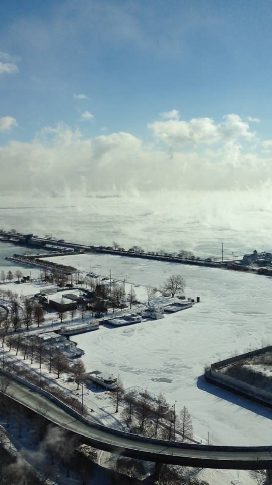
Steam and Clouds Over Lake Michigan A truly impressive and meteorological gee-whiz photo here sent to us by an NWS fan! The arctic air passing over breaks in the ice of Lake Michigan created pockets of quickly rising steam. Quite rare for off the Chicago shore, but picturesque! |
|
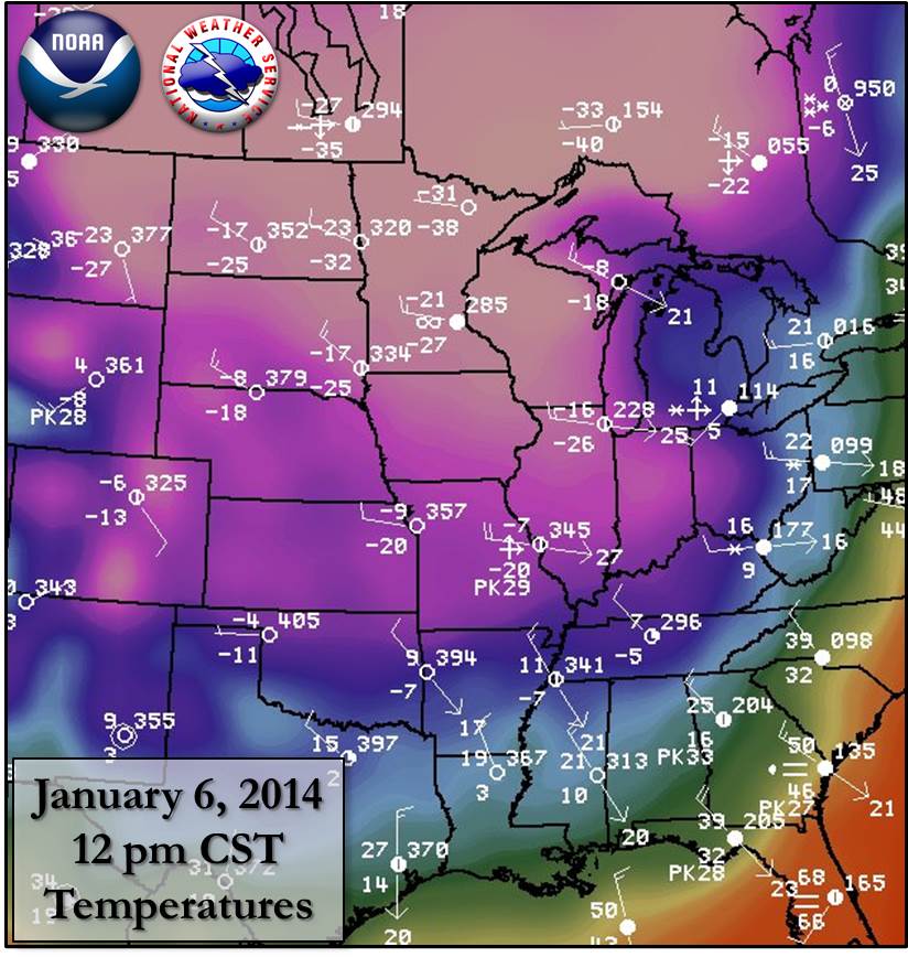
Graphics | Lowest Temperatures | Daytime Temperatures | Below Zero
For a larger high resolution click image
|
|
|
Lowest Temperatures
THE FOLLOWING ARE MINIMUM TEMPERATURES TAKEN AT OFFICIAL NATIONAL WEATHER SERVICE SITES.

LOCATION                        TEMPERATURES

AURORA/SUGAR GROVE AIRPORT..........-17.
DUPAGE AIRPORT......................-17.
CHICAGO-MIDWAY AIRPORT..............-15.
CHICAGO-0'HARE AIRPORT..............-16.
ROCKFORD AIRPORT....................-18.
WHEELING/CHICAGO EXECUTIVE AIRPORT..-15.
WAUKEGAN AIRPORT....................-16.
VALPARAISO INDIANA AIRPORT..........-16.
NWS ROMEOVILLE......................-17.
CHICAGO-NORTHERLY ISLAND............-13.

UNOFFICIAL SUPPLEMENTAL AWOS LOCATIONS
:
DKB: DEKALB                 :   M  /    M  /
JOT: JOLIET                 :  -9  /  -16  /
IKK: KANKAKEE               :  -6  /  -15  /
IGQ: LANSING                :  -5  /  -15  /
C09: MORRIS                 :  -9  /  -15  /
VYS: PERU                   :  -7  /  -14  /
PNT: PONTIAC                :  -8  /  -13  /
RZL: RENSSELAER IN          :  -6  /  -13  /
RPJ: ROCHELLE               :  -11 /  -18  /
ADDITIONAL SUPPLEMENTAL AUTOMATED LOCATIONS

THE FOLLOWING DATA PROVIDED BY NATIONAL WEATHER SERVICE COOPERATIVE
OBSERVERS.

:                                                  SNOW  SNOW
:LOCATION               DATE/TIME  MAX  MIN  PCPN  FALL  DEPTH
:NORTHEAST ILLINOIS...
ARRI2: AURORA         :   DH0700/  -11 / -17 / 0.00 /  0.0/   11
BARI2: BARRINGTON 3SW :   DH0800/  -13 / -19 / 0.00 /  0.0/   14
CBGI2: BOTANIC GARDENS:   DH0800/  -11 / -16 / 0.00 /  0.0/   11
MFWI2: MIDWAY COOP    :   DH0700/   -9 / -15 / 0.00 /  0.0/   12
DEKI2: DEKALB         :   DH0700/  -12 / -19 / 0.00 /  0.0/   10
ELGI2: ELGIN          :   DH0700/  -11 / -18 / 0.00 /  0.0/    6
JOLI2: JOLIET LOCK/DAM:   DH0600/  -10 / -16 / 0.00 /  0.0/   10
MHYI2: MCHENRY        :   DH0800/    M / -20 / 0.00 /  0.0/   10
MOSI2: MORRIS         :   DH    /   -8 / -16 / 0.00 /  0.0/    7
MUNI2: MUNDELEIN      :   DH0700/  -13 / -19 / 0.00 /  0.0/   11
OTTI2: OTTAWA 4SW     :   DH0733/   -9 / -17 / 0.00 /  0.0/    7
PKFI2: PARK FOREST    :   DH0500/    M / -13 / 0.00 /  0.0/    9

:                                                  SNOW  SNOW
:LOCATION               DATE/TIME  MAX  MIN  PCPN  FALL  DEPTH
:NORTHWEST ILLINOIS...
RCHI2: ROCHELLE       :   DH0600/  -12 / -19 / 0.00 /  0.0/    7
:                                                  SNOW  SNOW
:LOCATION               DATE/TIME  MAX  MIN  PCPN  FALL  DEPTH
:NORTHWEST INDIANA...
RZZI3: RENSSELAER     :   DH0730/   -4 /  -8 / 0.00 /  0.0/   12
VPOI3: VALPARAISO 5NNE:   DH0700/  -10 / -16 / 0.00 /  0.0/   15
:                                                  SNOW  SNOW
:LOCATION               DATE/TIME  MAX  MIN  PCPN  FALL  DEPTH
:EASTERN ILLINOIS...
CWWI2: DWIGHT         :   DH0700/   -9 / -16 / 0.00 /  0.0/   12
WATI2: WATSEKA        :   DH0700/   -9 / -16 / 0.00 /  0.0/    7
.END
OTHER ADDITIONAL SUPPLEMENTARY REPORTS
                                                   SNOW  SNOW
:LOCATION               DATE/TIME  MAX  MIN  PCPN  FALL  DEPTH
BATI2: BATAVIA        :   DH0600/  -11 / -17 / 0.00 /  0.0/    9
CTYI2: COAL CITY 4NNW :   DH0600/   -9 / -15 / 0.00 /  0.0/    8
|
January 6th Daytime High Temperatures |
|
|
PUBLIC INFORMATION STATEMENT
NATIONAL WEATHER SERVICE CHICAGO IL
206 PM CST MON JAN 6 2014 /306 PM EST MON JAN 6 2014/

...MONDAY`S RECORD LOW MAX WAS NOT SET BUT NOON TEMPERATURES
WERE AMONGST THE COLDEST ON RECORD...

A TECHNICALITY PREVENTED MONDAY FROM POSSIBLY TYING OR BREAKING
THE COLDEST DAILY HIGH TEMPERATURE EVER IN CHICAGO. THE MIDNIGHT
TEMPERATURE...WHILE BITTERLY COLD AND ALSO SETTING A DAILY RECORD
FOR CHICAGO...WILL BE THE DAILY HIGH MONDAY AND WAS NOT AT OR
BELOW THE ALL-TIME DAILY COLD HIGH TEMPERATURE RECORD OF -11.
NONETHELESS...MONDAY WILL GO DOWN AS ONE OF THE COLDEST DAYS ON
RECORD. HERE IS A RANKING OF THE COLDEST NOON TEMPERATURES ON
RECORD DATING BACK TO THE 1929-30 WINTERS IN CHICAGO AND ROCKFORD.

        CHICAGO
        -------
    TEMP       DATE
1)  -21     JAN 10 1982
2)  -17     JAN 20 1985
3)  -16     DEC 24 1985
4)  -15     FEB  9 1933
    -15     JAN 22 1936
    -15     JAN 16 1982
7)  -14     JAN 18 1994
   *-14     JAN  6 2014*
9)  -13     JAN 16 1977
10) -10     JAN 18 1940
    -10     JAN 28 1977
    -10     JAN  9 1982

        ROCKFORD
        --------
    TEMP       DATE
1)  -21     JAN 22 1936
    -21     JAN 10 1982
3)  -18     JAN 18 1994
4)  -17     JAN 16 1982
5)  -16     DEC 24 1983
    -16     FEB  3 1996
7)  -15     JAN 23 1963
    -15     JAN 16 1977
    -15     JAN 20 1985
    -15     DEC 21 1989
    -15     JAN 15 1994
    -15     FEB  2 1996
   *-15     JAN  6 2014*

$$

IZZI/RC
...LONG STREAK OF HOURS BELOW ZERO COMES TO A CLOSE AT CHICAGO AND
ROCKFORD...
THE LONG STREAK OF HOURS BELOW ZERO CAME TO AN END THIS AFTERNOON
IN CHICAGO AND ROCKFORD. FOR SOME HISTORICAL CONTEXT...HERE IS A
LOOK BACK AT SOME OF THE LONGEST DURATION PERIODS OF CONSECUTIVE
HOURS WITH SUBZERO TEMPERATURES IN CHICAGO AND ROCKFORD DATING
BACK TO THE WINTER OF 1929-30. THE 36 HOURS BELOW ZERO AT CHICAGO
FELL JUST OUTSIDE THE TOP 10.
CHICAGO
RANK # OF HOURS CLIMBED TO COLDEST TEMP
BELOW ZERO ZERO DURING STREAK
1) 98 DEC 26 1983 AT 11 AM -25
2) 66 FEB 4 1996 AT 2 PM -19
3) 60 JAN 11 1982 AT 8 AM -26
4) 48 JAN 21 1985 AT 8 AM -27
5) 45 JAN 19 1994 AT 2 PM -21
6) 44 JAN 6 1988 AT 1 PM -14
44 JAN 16 1994 AT 12 PM -17
8) 43 JAN 17 1977 AT 1 PM -19
9) 42 JAN 17 1982 AT 11 PM -25
10) 39 FEB 10 1933 AT 9 AM -19
** 37 JAN 7 2014 AT 1 PM -16 **
ROCKFORD
RANK # OF HOURS CLIMBED ABOVE COLDEST TEMP
BELOW ZERO ZERO DURING STREAK
1) 128 FEB 5 1996 AT 2 AM -24
2) 102 DEC 26 1983 AT 12 PM -24
3) 84(E) JAN 22 1970 AT 8 AM -22
4) 75(E) JAN 30 1966 AT 1 PM -20
5) 70 JAN 7 1988 AT 1 PM -19
6) 62 DEC 23 1989 AT 1 PM -20
7) 61 JAN 16 1994 AT 1 PM -21
8) 58 JAN 31 1951 AT 11 AM -19
** 40 JAN 7 2014 AT 1 PM -18 **
IN 1970 AND 1966 ROCKFORD TEMPERATURE RECORDS WERE 3 HOURLY...SO
THE DURATION WAS ESTIMATED AND COULD BE OFF BY A COUPLE OF
HOURS...BUT WOULD NOT BE ENOUGH TO IMPACT THE RANKING.
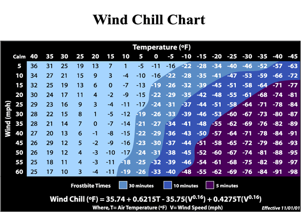
IN ADDITION TO THE BRUTALLY COLD TEMPERATURES...STRONG WINDS
RESULTED IN SOME OF THE COLDEST WIND CHILLS RECORDED IN MANY
YEARS. THESE WIND CHILLS FELL JUST OUTSIDE THE TOP 10 COLDEST
WIND CHILL RANKINGS. HERE IS A RANKING OF THE EVENTS WITH THE
COLDEST RECORDED WIND CHILLS DATING BACK TO THE WINTER OF
1929-30. THESE WIND CHILLS ARE BASED ON THE HOURLY OBSERVATIONS
AND ALL ARE WERE CALCULATED USING THE NEW WIND CHILL FORMULA.
CHICAGO
COLDEST
DATE WIND CHILL
1) JAN 10 1982 -60
2) DEC 24 1983 -59
3) JAN 20 1985 -58
4) JAN 17 1982 -53
5) JAN 22 1936 -52
6) FEB 9 1933 -51
7) JAN 18 1994 -50
8) JAN 16 1977 -48
9) JAN 18 1930 -48
10) JAN 15 1994 -44
** JAN 6 2014 -42 **
ROCKFORD
COLDEST
DATE WIND CHILL
1) JAN 10 1982 -59
2) JAN 22 1936 -58
3) DEC 24 1983 -57
4) JAN 20 1985 -57
5) FEB 9 1933 -55
6) JAN 18 1994 -53
7) JAN 16 1977 -53
8) JAN 16 1982 -51
9) JAN 28 1977 -49
10) JAN 23 1963 -49
** JAN 6 2014 -46 **
|
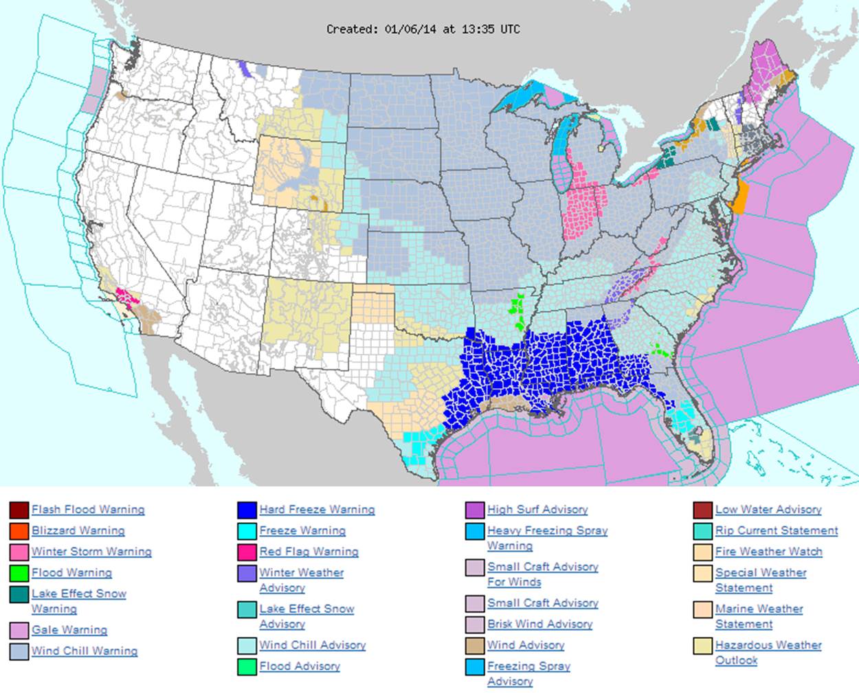
NWS Headlines at 7 am Jan 6th (Massive Areal Coverage of Wind Chill Warnings & Advisories) |
|
|
BELOW IS A LISTING OF THE LOWEST WIND CHILLS OBSERVED THROUGH
THE COLD AIR OUTBREAK. THE WIND CHILL IS A TERM USED TO DESCRIBE
THE HEAT LOSS ON THE HUMAN BODY RESULTING FROM THE COMBINATION OF
TEMPERATURES AND WIND SPEEDS.

OBSERVATIONS ARE COLLECTED FROM A VARIETY OF SOURCES WITH VARYING
EQUIPMENT AND EXPOSURE. NOT ALL DATA LISTED ARE CONSIDERED OFFICIAL.

LOCATION                       TEMP      TIME/DATE

...ILLINOIS...

...COOK...
LANSING                        -44       0935 AM 01/06
CHICAGO OHARE AIRPORT          -42       0951 AM 01/06
CHICAGO MIDWAY AIRPORT         -41       0951 AM 01/06
WHEELING                       -41       0852 AM 01/06

...DUPAGE...
DUPAGE AIRPORT                 -46       0935 AM 01/06

...FORD...
PAXTON                         -42       0932 AM 01/06

...GRUNDY...
MORRIS                         -44       0815 AM 01/06

...KANE...
AURORA MUNICIPAL AIRPORT       -47       0752 AM 01/06

...KANKAKEE...
GREATER KANKAKEE AIRPORT       -43       0915 AM 01/06

...LA SALLE...
PERU                           -41       0515 AM 01/06

...LAKE...
WAUKEGAN REGIONAL AIRPORT      -41       0752 AM 01/06

...LEE...
2 SSE STEWARD                  -50       0930 AM 01/06

...LIVINGSTON...
PONTIAC                        -42       0655 AM 01/06

...OGLE...
ROCHELLE                       -47       0735 AM 01/06

...WILL...
ROMEOVILLE                     -46       0915 AM 01/06
JOLIET PARK DISTRICT AIRPORT   -42       0855 AM 01/06

...WINNEBAGO...
CHICAGO/ROCKFORD INTERNATIONAL -46       0954 AM 01/06

...INDIANA...

...JASPER...
RENSSELAER                     -42       0955 AM 01/06

...PORTER...
VALPARAISO                     -46       0843 AM 01/06


 Follow us on YouTube