|
|
||||||||||||||
| Overview | Timeline | Meteorology | Lessons | Map & Photos | Sources | |||||||||
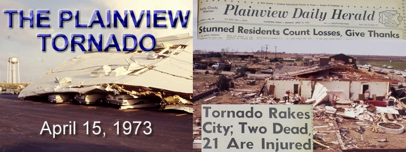
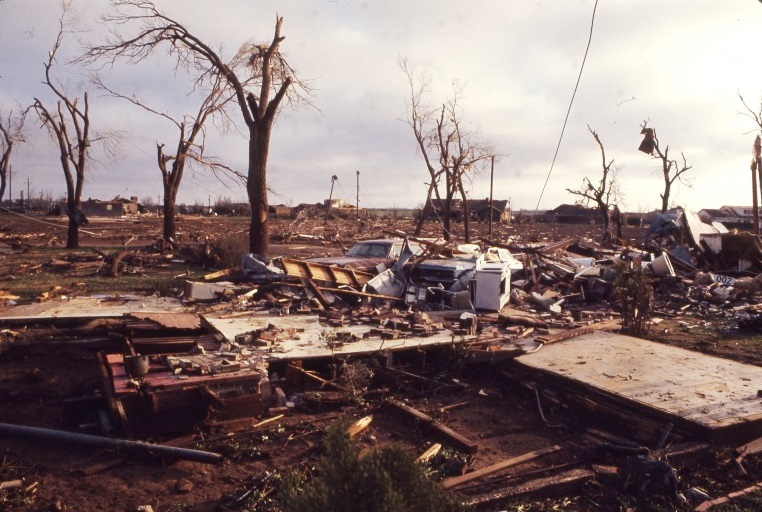 Following a devastating nighttime tornado just three years earlier on April 17, 1970, the city of Plainview, TX was struck again by another significant tornado during the pre-dawn hours on April 15, 1973. Sadly, two persons were killed and at least 21 injured as this F3 tornado churned through the west and northwest sections of Plainview. Approximately $4 million in property damage was sustained and 40 residences destroyed; many of which were located in the newly constructed Westridge Park housing addition. Considering this tornado struck at 4:15 am CST on a Sunday, it is extremely fortunate that more lives were not lost. Much of this fact can be attributed to the proactive efforts of Plainview’s emergency management and dedicated storm spotters. Quickly heeding weather warnings from the National Weather Service in Lubbock, the Plainview Emergency Operations Center (EOC) and dedicated storm spotters were activated shortly after 4 am CST. One of these spotters, 30-year old David Bryant, provided crucial reports of this tornado and its location moments before he was fatally injured by the tornado. In the following days, a NOAA Natural Disaster Survey Team along with members of the Lubbock Weather Service Forecast Office investigated the damage area and met with members of the Plainview EOC. One of the most significant findings by the survey team was the value of communities establishing storm preparedness plans for such significant weather events. For a city of its size, the Plainview EOC at the time was described as among the best equipped and organized units in the nation.
|
||||||||||||||
|
Timeline (in CST)
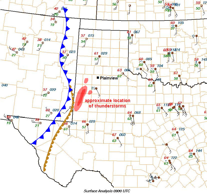
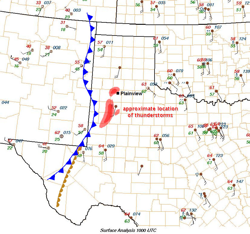
2:15 am: A line of thunderstorms began developing rapidly from west of Brownfield to Seminole, TX. 2:30 am: WSFO Lubbock issued a Severe Thunderstorm Warning for Yoakum and Gaines Counties valid until 4:00 am. 2:50 am: WSFO Lubbock extended the Severe Thunderstorm Warning to include Terry and Hockley Counties. 3:10 am: Tornado Watch Number 118 was issued by the National Severe Storms Forecast Center for a large portion of West Texas. The watch was effective from 4:00 am until 10:00 am. The Weather Wire State Relay Center at WSFO Fort Worth, TX appended the watch to specifically list Hale County. 3:30 am: WSFO Lubbock issued a Severe Thunderstorm Warning specifically for Hale County which was valid till 4:30 am. At this time, a line of severe thunderstorms was indicated by the WSR-1 radar in Lubbock from 10 miles southeast to 10 miles east of Littlefield. These storms were moving northeastward at 30 mph. 3:45 am: WSFO Lubbock issued a Severe Thunderstorm Warning for Lubbock County which was valid until 6:00 am. The warnings for Terry, Hockley, and Hale Counties were also extended to 6:00 am at this time. The warning also stated that a Tornado Watch was in effect also for these counties. 3:55 am: Radar indicated very strong echoes near Carlisle, 10 miles west-southwest of the Lubbock Airport. This area was near the north end of a Line Echo Wave Pattern (LEWP). 4:10 am: Tornado sirens were sounded in Plainview after two Plainview police officers radioed the police station that a tornado was on the ground southwest of the Westridge addition. Visual confirmation was made possible by power flashes from failing transformers. The police officers were later injured by the tornado while in their patrol car. 4:10-4:15 am: Large hail and fierce wind howls were reported in southwest Lubbock from the LEWP. 4:15 am: Tornado moves through Plainview. Also during this time, WSFO Lubbock issued a Severe Weather Statement stating that a line of heavy thunderstorms at 4:10 am was located from 10 miles north of Plainview to the western edge of Lubbock to 10 miles north of Brownfield. Several reports of heavy rain and small hail were reported in the western portion of Lubbock, and one report of golf ball size hail was received from the southern edge of Lubbock. 4:25 am: Plainview police reports to WSO Amarillo that a tornado has hit the city. 4:33 am: WSFO Lubbock receives the initial report of the Plainview Tornado from WSO Amarillo. 4:35 am: WSFO Lubbock issued a Tornado Warning for the northeastern portion of Hale County. |
||||||||||||||
|
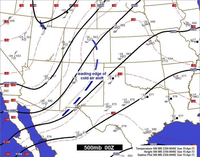
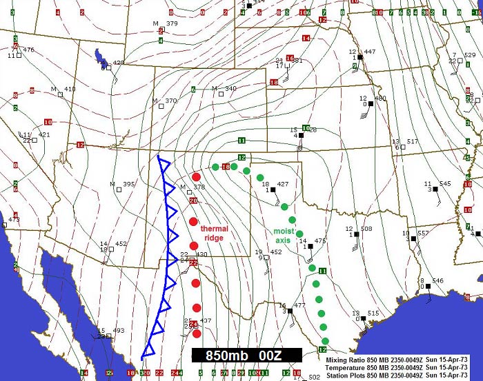
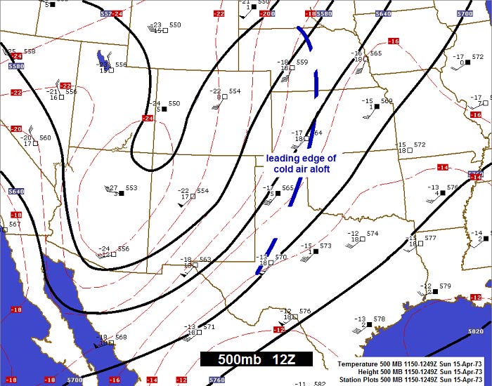
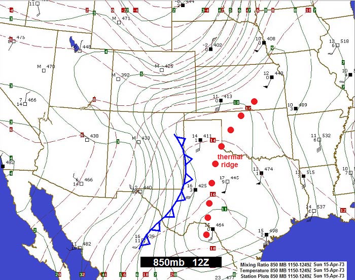
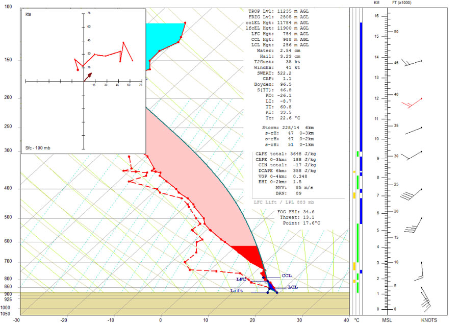
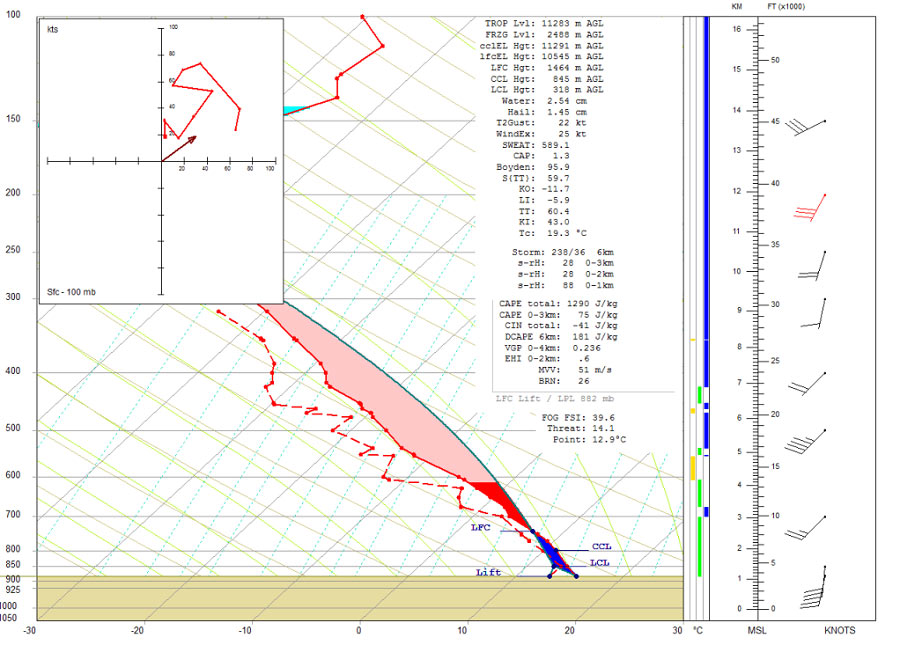
The evening prior to the Plainview tornado was already active with scattered severe thunderstorms over portions of the Texas South Plains and the Texas Panhandle. By midnight, these thunderstorms diminished greatly in coverage and intensity leading many residents to believe that a quiet night was ahead. However, farther west in New Mexico, a Pacific cold front and cooler air aloft in advance of a sharpening upper-level trough were quickly marching eastward. Shortly after 2 am CST, the cold front collided with a dryline poised from near Morton, TX southwest to Hobbs, NM. The result was explosive thunderstorm development in the form of a squall line. Using a WSR-1 local radar, meteorologists at the NWS office in Lubbock began issuing severe thunderstorm warnings for this squall line. Immediately north of the line of thunderstorms, radar began detecting a distinctly singular and particularly intense storm approaching Hale County. NWS meteorologists recognized this storm's potential for severe weather and immediately issued a severe thunderstorm warning for Hale County. Unfortunately, weather radars at the time were not capable of detecting rotation within storms. Instead, thunderstorm rotation had to be inferred using reflectivity patterns such as hook echoes or even the presence of a bounded weak echo region. The only archived radar data from this event were routine radar observations created by hand from meteorologists at WSO Midland. Although crude in detail, the Midland WSR-57 radar did indicate a discrete and intense storm in Hale County directly north of the LEWP.
|
||||||||||||||
|
Due in large part to a significant nighttime tornado three years earlier, the city of Plainview was highly proactive about severe weather preparedeness and emergency response operations. This is a relatively common trait observed in communities for several years following such natural disasters; however, the city of Plainview excelled in their level of preparation and training for future disasters. The degree of resources and efficient communication was found to be exemplary by a national NWS survey team in the days following the 1973 tornado. Considering this tornado struck before dawn on a Sunday, it is amazing (even by today's standards) that storm spotters willingly manned their stations to serve their community with timely severe weather reports. These reports proved valuable in giving residents advance notice of the approaching tornado. A detailed survey of area residents after the tornado indicated that many people were made aware of the threat after being awakened by the city's tornado sirens. This prompted some to leave their homes for outdoor shelters; however, at the same time this action increased their risk of exposure to flying debris. Other residents chose not to act until the winds became so fierce that they sought any means of shelter in the rooms they occupied when the tornado struck. Both of the fatalities occurred outdoors. In the case of the storm spotter that died, he was aware of the personal risk, but decided to put service before self and help protect his community by providing crucial storm reports. However, the other fatality was a child who perished from falling tornado debris while being rushed to an outdoor storm shelter. Some of the 21 people injured were also caught outdoors in pursuit of shelter. A study of this event proposed that the number of injuries and fatalities could have been reduced had the tornado sirens not been activated. While certainly plausible, had the Plainview tornado been any stronger and not received advance warning via tornado sirens, the tolls would likely have been far worse as residents would stand less chance of survival not being in their basements or storm shelters. |
||||||||||||||
|
||||||||||||||
|
|
||||||||||||||
|
|
||||||||||||||


 Follow us on YouTube