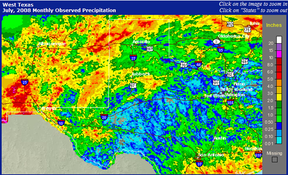
After a relatively dry stretch, much of West Texas received some beneficial rainfall during a 10 day period in mid July. The weather pattern shifted with a large ridge of high pressure aloft becoming established from the lower Mississippi valley into east Texas - with a weaker ridge across Arizona and New Mexico. West Texas was located between these two ridges. The flow of winds around the systems brought a plume of rich sub tropical moisture into the area from the Pacific and the Gulf of Mexico. Weak upper-level disturbances moved across the Rockies and into the high plains - helping to trigger shower and thunderstorm activity. Also, a weak vertical wind profile, typical across the southern U.S. during mid/late summer, caused the thunderstorms to move slowly, which, when coupled to the abundant moisture, brought at least the potential for heavy rain. This potential was realized mainly on a local basis. Much of the activity occurred at night - as a series of thunderstorm complexes developed and tracked across the region. Due to the weak weak winds aloft, the thunderstorms were generally not very strong, but on July 12th, a upper-level disturbance and a seasonally strong cold front combined to produce some severe weather. There were several hail reports up to the size of golf balls in Lubbock and Hockley Counties, and severe wind gusts up to 60 mph were reported across Garza County. In addition, on July 15th, street flooding was reported in Brownfield when a strong storm passed over the town.
Compare the image above to the one below which shows the rainfall for the month of July (updated through the 24th). The data in the image below includes both rain gauges and radar-derived rainfall. In general, you can see the same rainfall pattern across the South Plains and Rolling Plains but also of interest is the abundant rainfall which fell across the western and northern Texas Panhandle, which has helped to raise the level at the Lake Meredith Reservoir near Amarillo slightly.
|
|||
|
|


 Follow us on YouTube