|
|
2009:
WEATHER OF WEST TEXAS
|
|
|
Plane crash at Lubbock Airport -
27 January 2009
|
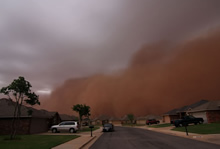
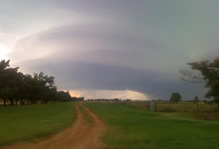
Haboob moving across southwest Lubbock -
27 May 2009 |
|
As usual, 2009 brought a wide variety of weather to the South Plains area. The year started off with an ongoing drought across much of the Rolling Plains. Rainfall was very spotty through the first half of the year which caused drought conditions to intensify to extreme levels (D3) over the southern Rolling Plains of West Texas by the end of May. The economic loss due to the drought was estimated at $24 million dollars.
April and May brought several outbreaks of severe weather, including hail storms to both Lubbock and Tulia on April 16th. The hail damaged many roofs across the respective cities. Thirteen tornadoes were also reported that day, although the impacts from the hail and heavy rain were much more widespread.
By June, beneficial rains began to ease the drought across the Rolling Plains. On June 18th, a haboob (dust storm) created by a thunderstorm contributed to a small plane crash in Floyd County. On July 17th, a cluster of thunderstorms - including a long-lived supercell - moved south through the western South Plains causing widespread hail and wind damage. On July 29th, a complex of thunderstorms resulted in the partial collapse of a brick structure in Estelline (Hall County). More significant damage occurred as the winds spread into Childress (Childress County), where a number of buildings were heavily damaged, including three local hotels, a hospital, and the high school as measured wind gusts reached 102 mph. Three people were injured and economic losses across this area exceeded $2.2 million.
The remainder of the year we did not see much severe storm activity across the region. Winter arrived a little earlier than usual across parts of the Caprock as a storm system on October 29th brought a wintry mix over much of the western and central South Plains, and light snow over the extreme southwestern Texas Panhandle. December brought a snowstorm and very cold temperatures just in time for the Christmas holiday.
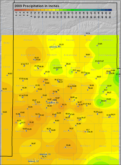
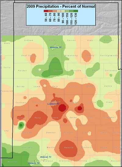
For the year, above average rainfall fell across the far southern Texas Panhandle, through the Childress area (see the maps below). Elsewhere, yearly rainfall totals were anywhere from 30 to 50 percent below normal across much of the South Plains and Rolling Plains. The relative bulls-eye of moisture across far southern Yoakum County was due to spotty but heavy rainfall which hit the Co-op station in Denver City.
|
|
|
|
This map displays the 2009 year precipitation totals. The map was created with data gathered from the NWS Cooperative observers and the West Texas Mesonet. Click on the map to view a full-sized version.
|
|
|
| This map shows the 2009 rainfall as a percent of the 30-year normal rainfall (1971-2000). Please click on the map to view a full-sized version. If you would like to see the precipitation as a departure from normal please click here. |
Below are some statistics from 2009 for Lubbock:
Overall, 2009 was a relatively dry year with 9 of the 12 months recording below average precipitation. The only months to record above average precipitation were February (+0.02 inches), April (+0.22 inches) and December (+0.67 inches). Lubbock finished the year with 12.87 inches - 5.82 inches short of the average.
Lubbock recorded 14 100-degree days in 2009, four of which occurred successively from July 8th-11th. The highest temperature of the year was 107 degrees, recorded on July 9th. On the other extreme, the coldest temperature recorded for the year was 5 degrees on December 25th. Additionally, 11 record highs were set or tied in 2009: 77 on January 2nd (tie); 79 degrees on January 22nd (tie); 80 degrees on February 6th; 85 degrees on February 23rd (tie); 88 degrees on March 3rd; 89 degrees on March 4th; 84 degrees on March 23rd (tie); 100 degrees on May 7th; 106 degrees on July 8th; 107 degrees on July 9th (tie); and 93 degrees on October 14th. Four record lows were set or tied in 2009: 41 degrees on September 23rd; 40 degrees on October 2nd (tie); 37 degrees on October 10th; and 34 degrees on Oct 11th.
|
LUBBOCK
|
Average High
|
Average Low
|
Precip (inches)
|
|
January
|
59.7
|
24.5
|
0.13
|
|
February
|
65.8
|
33.0
|
0.73
|
|
March
|
72.0
|
39.5
|
0.37
|
|
April
|
|
45.6
|
1.51
|
|
May
|
82.7
|
55.7
|
0.68
|
|
June
|
92.9
|
66.2
|
2.44
|
|
July
|
93.7
|
68.5
|
1.69
|
|
August
|
94.6
|
67.2
|
0.47
|
|
September
|
83.3
|
57.5
|
2.46
|
|
October
|
72.0
|
44.3
|
0.78
|
|
November
|
69.2
|
36.2
|
0.13
|
|
December
|
48.4
|
23.6
|
1.48
|
|
Annual
|
75.9
|
46.8
|
12.87
|
|
Normal
|
73.2
|
46.2
|
18.69
|
|
Departure
|
+2.7
|
+0.6
|
-5.82
|
The two graphs below show the daily high and low temperature distribution throughout the year at the Lubbock Airport. Temperatures were generally slightly above average, except in December, where a cold period at the first of the month and during Christmas led to the month being below average.
|
|
| Plot of the maximum (top) and minimum temperatures (bottom) observed at the Lubbock airport in 2009. Also plotted are the respective normals and records for each date. Units are in degrees Fahrenheit. Click on the images for a larger view. |
|
|
The graph below shows the yearly distribution of precipitation for 2009. Only three times did greater than 0.7 inches of rain fall in a day at Lubbock: Feb 8th, April 16th, and Sept. 8th. 1.56 inches on Sept. 8th was the highest amount.
|
|
| Plot of the cumulative and daily precipitation (in inches) recorded at the Lubbock airport in 2009. Also plotted is the 30-year average precipitation. Click on the image for a larger view. |
|
|
2009 TORNADOES AND OTHER SEVERE WEATHER
|
|
|
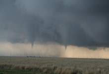
Photograph of two tornadoes across northeast Floyd County, 29 April 2009
|
Supercell thunderstorm approaching Paducah - 14 June 2009
|
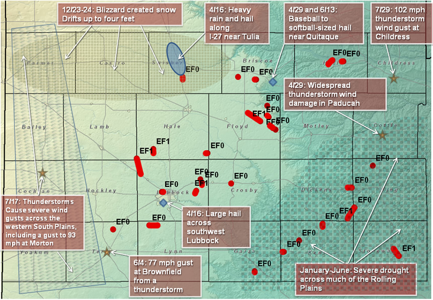
29 tornadoes were reported across the Lubbock forecast area in 2009. While this number is higher than average, the majority (24) of these tornadoes were short-lived and relatively weak (EF0 - damage corresponding to wind speeds of 65-85 mph). Five EF1 tornadoes were reported (damage corresponding to wind speeds of 86–110 mph).
The tornadoes and other noteworthy weather events are plotted on the below map. If you would like more detailed information about the events plotted on the below map, or a more comprehensive summary of significant weather events in 2009, please refer to the following section.
|
|
|
Map displaying the 29 reported tornadoes that impacted the Lubbock forecast area in 2009. Also plotted are a few of the other significant weather events of the year. Click on the image for a larger view.
|
|
|
5th: A quick burst of sleet moved across parts of the South Plains and Rolling Plains during the early morning hours. To learn more about this event CLICK HERE.
26-27th: A variety of light wintry weather visited much of the region. Although amounts were minor, they created travel troubles. To read more about the event CLICK HERE.
8th: Thunderstorms erupted along a dryline in eastern New Mexico and then formed into a squall line as they raced eastward into Texas. The squall line produced severe wind gusts at a number of locations across the western South Plains and southwest Texas Panhandle, including a wind gust to 69 mph near Denver City.
13th: A passing storm system brought rain, freezing rain and snow to parts of the area. Anywhere from a trace to over 4 inches of snow fell across the southern Texas Panhandle and northeast South Plains. Silverton reported 4 inches of snow, with Friona and Floydada reporting 3 and 2.5 inches, respectively. To read more about this event CLICK HERE.
27th: A dangerous blizzard struck portions of the southern plains, with as much as 25 to 30 inches of wind blown snow. Although the greatest impacts from this storm system remainded to the north, from the central Texas Panhandle into northwest Oklahoma, southwest Kansas and southeast Colorado, lesser amounts of snow and winds did affect the South Plains area. Anywhere from 1 to 4 inches of snow fell, including 4 inches at Bovina and Silverton and 3 inches at Farwell, Happy, Turkey, and Vigo Park. The snow, coupled with wind gusts over 40 mph, created hazardous driving conditions across portions of the southern Texas Panhandle, including near white out conditions and snow drifts up to 2 to 3 feet in depth in Parmer County.
4th: A dynamic storm system brought strong to severe wind gusts and blowing dust to West Texas. The windy conditions combined with warm and very dry air to support a number of wind-driven wildfires. The strongest winds and largest wildfires occurred across the Texas Panhandle. Bushland recorded a wind gust to 74 mph, with Friona and Dimmitt both experiencing gusts to 65 mph. The reduced visibilities in blowing dust caused numerous traffic accidents and at least one fatality near Amarillo. To read a more detailed report on this day CLICK HERE.
11-12th: Easter weekend was a wet one, with most of the South Plains region seeing anywhere from a third of an inch to an inch of liquid. In addition, a couple of severe thunderstorms impacted areas around Denver City and Childress. For details on this wet holiday weekend CLICK HERE.
16th: A strong storm system produced an outbreak of severe thunderstorms across the region. The severe storms produced large hail, several tornadoes, and locally flooding rains. One storm brought copious amounts of rain and hail to Tulia, and resulted in a portion of I-27 being closed for an extended time. Another storm brought an lengthy period of large hail to the southern parts of Lubbock. To learn more about this event CLICK HERE.
29th: Severe thunderstorms developed and affected the northeast South Plains, southeast Texas Panhandle, and portions of the Rolling Plains. Strong instability coupled with a residual outflow boundary conspired to produce a couple of tornadic storms. One storm produced a tornado west of Estelline, with several tornadoes touching down with another storm in eastern Floyd county (near Cedar Hill). Additionally, tennis ball to baseball sized hail fell at a number of locations. For more information on this day CLICK HERE.
12th: Scattered severe thunderstorms tracked across the southern Texas Panhandle during the early evening hours, with large hail and gusty winds. One storm produced golf ball sized hail near Turkey and a wind gust to 65 mph near Childress. A second cluster of strong to severe thunderstorms then developed and moved across the Rolling Plains later in the evening with more strong winds and large hail, including hail to the size of golf balls near Cee Vee. To learn more about this event CLICK HERE.
24th: A couple of brief landspout-type tornadoes occurred, one near Petersburg and another near Dougherty. No damage was reported with either tornado.
26th: A lone severe thunderstorm tracked across the central South Plains during the evening hours. Quarter-sized hail and wind gusts to 62 mph were reported near Idalou.
1st: Scattered afternoon thunderstorms across the Texas Panhandle congealed into a small complex and moved southeast across the Rolling Plains during the evening hours. Although instablity was rather limitted, the storms did occassionally eclipse severe thresholds producing a 62 mph wind gust near Turkey and 1-inch hail in Ralls. Additional strong thunderstorms developed that night and tracked from near Plainview into the Rolling Plains. To read more about this thunderstorm activity CLICK HERE.
2nd: An outflow boundary provided the focus for widespread severe thunderstorms across the South Plains and Rolling Plains during the afternoon and evening hours. Numerous reports of golf ball-sized hail were received, with baseball-sized hail observed at Clairemont and east of Post. Additionally, a wind gust to 72 mph occurred near Lake Alan Henry. A summary of this days weather can be found HERE.
4th: A complex of thunderstorms produced strong to severe wind gusts across much of the Caprock, with localized hail and heavy rain. A peak wind gust of 74 mph was recorded at Reese Center and 77 mph at Brownfield. More information on this event can be garnered HERE.
13-14th: This weekend brought a couple of rounds of wild weather to the region. The majority of the severe weather occurred across the Rolling Plains on the 13th, with the most intense cell tracking across Aspermont and producing a 100 mph wind gust just northeast of town. Severe storms redeveloped farther westward on the 14th, with strong winds and hail affecting Brownfield and Idalou, and a supercell thunderstorm tracking over Cottle County with large hail. For more detailed information on this weekend CLICK HERE.
18th: Gusty thunderstorm outflow winds produced a haboob that rolled across portions of the southern and central South Plains during the evening hours. Rainfall amounts were light, but a few locations did clock wind speeds in excess of 58 mph. Read more about this haboob HERE.
19-20th: A large batch of showers and thunderstorms, thanks in part to moisture from the remnants of a tropical storm in the eastern Pacific, produced heavy rain across the western and central South Plains and southwest Texas Panhandle. Many locations recorded 2 to 3+ inches. Read more about this heavy rain event HERE.
17th: Thunderstorms congealed into a complex that raced southward across the southwest Texas Panhandle and western South Plains. The storms brought widespread strong winds of 60 to 75 mph, along with a swath of large hail. An extreme wind gust of 93 mph was recorded near Morton. Learn more about this event HERE.
22nd: A large complex of showers and thunderstorms brought moderate to heavy rain to the western South Plains. A number of locations received 2+ inches of rain. Read more about the mid-July rain HERE.
29th: Several clusters of thunderstorms brought strong winds to much of the region. However, one storm produced an extreme wind gust of 103 mph in Childress, resulting in damage at a number of places. Read more HERE.
26th: A thunderstorm produced a non-mesocyclonic tornado over the Rawls Golf Course in northern Lubbock. No damage was reported.
11-13th: A slow moving upper level storm system brought moderate to heavy rain to locations off the Caprock. Many locations recorded 1 to 2 inches, with locally higher amounts, including over 3 inches near Paducah. To learn more about the rainy weekend CLICK HERE.
8th: A severe thunderstorm produced quarter size hail at Guthrie. The hail delayed the release of school in Guthrie.
29th: Light snow developed across the southwest Texas Panhandle, with up to an inch falling around Rhea.
1-30th: The weather was generally warm and dry. The high temperature at Lubbock exceeded 70 degrees on 16 days - with a high of 83 degrees on the 6th.
8th: After a prolonged period of freezing fog and freezing drizzle, and a brief period of snow and/or sleet and/or rain, the region was greeted by a round of strong winds and blowing dust. Learn more about the variable weather early this December day HERE.
23-24th: A powerful winter storm brought widespread snow, blowing snow and strong northerly winds. Many locations received 3-6 inches of snow, with locally higher amounts. The cold weather and strong winds also created hazardous travel conditions. To read a story about this event CLICK HERE.
29th: Another winter storm system brought widespread light snow to the region.


 Follow us on YouTube