 |
2010:
WEATHER OF WEST TEXAS |
 |
|
Snow in southern Lubbock -
23 February 2010 |
Flooding at Huneke Park in Lubbock - 4 July 2010 |
|
|
Late April, May and parts of June brought several outbreaks of severe weather, including a storm on the 22nd of April that became tornadic and produced significant damage near Cee Vee in Cottle County. Storms on the 25th of May brought up to softball sized hail near Progress, with a couple of brief tornadoes close to Dimmitt. An early morning thunderstorm complex produced a strong macroburst, with a 101 mph wind gust measured near Turkey on the 14th of June, which resulted in damage to several rural structures. June was a hot one, but the heat was quickly thwarted in early July as very heavy rain washed out the 4th of July weekend. Many locations recorded in excess of 5 inches of rain, with over 9 inches across parts of the central and southern South Plains. An astounding 14.20 inches of rain was measured at Draw, in southeast Lynn County, over the first 4 days of July. The heavy rain resulted in flooding, flash flooding and river flooding with millions of dollars in damage done. After all the heavy rain in the first part of July, and the abundant precipitation during the first half of the year, rainfall became scarcer to close out the year. Isolated to scattered storms did visit much of the area through the middle of August and on into September, but the rainfall was not as widespread or as intense as earlier in the year. One final round of fairly widespread heavy rain and severe weather struck on October 21st. Locations from Brownfield to Meadow were hardest hit with over 4 inches of rain and golf ball sized hail. Much of the remainder of the year was relatively quiet, though a strong storm system did bring a brief shot of rain and even a little snow to the southwest Texas Panhandle on November 12th. The end of the 2010 was characterized by strong winds, though little precipitation, as a large and potent storm system tracked by. |
||
|
|
|
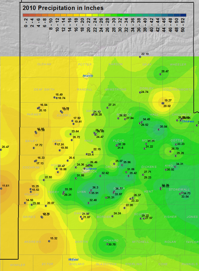
This map displays the 2010 year precipitation totals. The map was created with data gathered from the NWS Cooperative observers and the West Texas Mesonet. Click on the map to view a full-sized version.
|
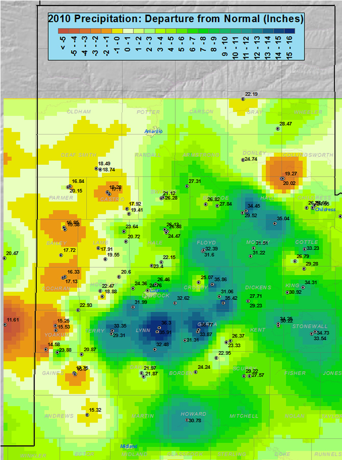
The above map shows that 15-20 inches of total rainfall was rather common for the year across western sections of the South Plains and southwest Texas Panhandle, which was close to or just below average. A tight rainfall gradient then exists further east, with much of the central and eastern sections getting 25-30+ inches, except around Memphis where only around 20 inches fell. The highest yearly total in the area was 36.77 inches, recorded in Post. As the below map illustrates, aside from the western sections and near Memphis, most of the area saw 120 to more than 150 percent of normal precipitation for 2010.
|
|
| This map shows the 2010 rainfall as a percent of the 30-year normal rainfall (1971-2000). Please click on the map to view a full-sized version. If you would like to see the precipitation as a departure from normal please CLICK HERE. |
Below are some statistics from 2010 for Lubbock:
The year of 2010 will go down in the books as being much wetter and slightly warmer than average. The first major winter storm brought a variety of weather including rain, thunderstorms, ice and snow to the region on the 28th of January, with Lubbock officially receiving 1.36 inches of liquid. The large dump of precipitation put Lubbock above average for the year and we never looked back as the first four months of 2010 all finished well above average. Monthly rain totals did fall back below average for May and June, but record rains over the 4th of July weekend pushed the yearly total above the average yearly rainfall by the 4th. However, as is typically for West Texas, the pendulum swung the other way and 4 of the final 5 months finished with less precipitation than average. Even with the relatively dry ending, Lubbock finished the year with 26.46 inches - 7.77 inches above average.
Lubbock recorded only two 100-degree days in 2010 and both of them occurred during the first half of June. The highest temperature of the year was 105 degrees, recorded on June 5th. The other 100-degree day occurred on the 10th, when the mercury hit 102 degrees. On the other extreme, the coldest temperature recorded for the year was 11 degrees on January 8th. Additionally, 5 record highs were set in 2010: 91 degrees on March 30th; 90 degrees on October 30th; 82 degrees on December 3rd; 82 degrees on December 14th; and 80 degrees on December 15th. One record low was set in 2010: 51 degrees on August 26th.
|
LUBBOCK
|
Average High
|
Average Low
|
Precip (inches)
|
|
January
|
53.2
|
25.3
|
1.41
|
|
February
|
49.8
|
28.7
|
1.78
|
|
March
|
65.9
|
36.7
|
2.85
|
|
April
|
73.6
|
48.3
|
4.65
|
|
May
|
82.5
|
56.5
|
1.14
|
|
June
|
93.9
|
68.0
|
2.55
|
|
July
|
86.5
|
68.2
|
7.14
|
|
August
|
93.2
|
67.3
|
1.33
|
|
September
|
87.9
|
61.8
|
0.93
|
|
October
|
79.4
|
47.9
|
2.61
|
|
November
|
66.9
|
34.7
|
0.07
|
|
December
|
60.6
|
30.2
|
T
|
|
Annual
|
74.5
|
47.8
|
26.46
|
|
Normal
|
73.2
|
46.2
|
18.69
|
|
Departure
|
+1.3
|
+1.6
|
+7.77
|
The graph below shows the daily high and low temperature distribution for 2010 at Lubbock Preston Smith International Airport. Temperatures showed pretty common variability throughout much of the year, and were generally slightly above average. However, the variability was notably damped during the first half of February and through much of July, when high temperatures were also below average. These atypical periods correspond to times during and shortly after heavy precipitation events (January 28th and February 3rd rain and snow events and the early July heavy rain event). This makes sense because added moisture, like that provided by the rain and snow events, commonly has the effect of damping diurnal temperature swings, with cooler highs and warmer lows.
 |
| Plot of the maximum and minimum temperatures (connect by the dark blue bars) observed at the Lubbock Preston Smith International Airport in 2010. Also plotted are the respective normals (light orange line - average high; light blue line - average low) and records (thick orange line - record high; thick blue line - record low) for each date. Units are in degrees Fahrenheit. Click on the graph for a larger view. |
The graph below shows the yearly distribution of precipitation for 2010 at Lubbock. The year was punctuated by bouts of heavy precipitation, most frequently during the first half of the year. Over one inch of rain fell on 11 different days, with greater than two inches on four different occasions (April 16th, July 2nd, July 3rd, and October 21st). July 3rd brought the heaviest daily rainfall of the year with 3.27 inches. The large amount of days with heavy precipitation contributed to 2010 finishing nearly 8 inches above average.
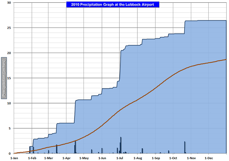 |
| Plot of the cumulative (blue) and daily precipitation (black), in inches, recorded at the Lubbock Preston Smith International Airport in 2010. Also plotted is the 30-year average precipitation (red). Click on the image for a larger view. |
 |
2010 TORNADOES AND OTHER SEVERE WEATHER
|
 |
|
Tornadic thunderstorm near Cee Vee - |
Thunderstorm viewed from South Plains -
21 May 2010 |
Eight tornadoes were reported across the Lubbock forecast area in 2010. While this number is lower than average, two of them that occurred on April 22nd were significant. One tornado, rated at EF2 (damage corresponding to wind speeds of 110-137 mph), developed south of Northfield and crossed the Motley and Cottle County line southwest of Cee Vee. This 3/4 mile wide tornado destroyed windmills and utility poles as it tracked through rural ranchlands. A second tornado from the same parent storm formed a 3/4 mile wide rain-wrapped tornado that track south and southeast of Cee Vee and heavily damaged or destroyed three farmsteads. This tornado was also rated EF3, with damage corresponding to estimated winds of 138-167 mph. Thankfully, no injuries were reported from either of these tornadoes.
The remaining 6 tornadoes observed in 2010 were relatively minor and short-lived and rated as EF0. In addition to the two damaging tornadoes on April 22nd, one weak tornado was noted near Swearingen. Three other brief tornadoes dropped in Castro County, near Dimmitt, on May 25th. The last two weak tornadoes occurred on June 2nd and 14th near New Home and Wilson, respectively.
|
|
|
Map displaying the 8 reported tornadoes that impacted the Lubbock forecast area in 2010. Also plotted are some of the other significant weather events of the year. Click on the image for a larger view |
MONTHLY 2010 HIGHLIGHTS:
| JANUARY: |
| FEBRUARY : |
| MARCH: |
| APRIL: |
| MAY: |
| JUNE: |
| JULY: |
|
AUGUST:
|
| SEPTEMBER: |
| OCTOBER: |
| NOVEMBER: |
| DECEMBER: |


 Follow us on YouTube