|
Welcome Rains Return to the Southern Plains September 14-16, 2011 |
|
|
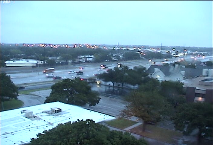
| Dawn breaks over the city of Lubbock to a welcome sight - light to moderate rain showers spreading across the region. The showers generally brought between one half to one inch across the city and surrounding areas, resulting in some minor street flooding. Image taken from the webcam of the NWS Lubbock's webcam on the roof of the Science Spectrum along South Loop 289. |
| After another bout of record high temperatures was observed across the region, a strong cold front pushed through the South Plains during the morning of September 14, bringing a cooler airmass into the area as high temperatures dropped from the upper 90s and lower 100s (on the 12 & 13) into the upper 60s and 70s on the 14th and only into the 50s on the 15th! This front was able to focus some of the low to mid-level moisture across the area to generate several rounds of showers and thunderstorms from the late morning of the 14th through the early morning hours of the 16th. While these showers and storms were able to produce some beneficial rains across most of the area, the overall impact they make on the drought will not be very significant if dry conditions persist through most of the autumn months. |
|
|
| Radar animation valid from 12:18 am to 1:38 am CDT on September 15, 2011. The initial area of storms can be seen pushing eastward across the Rolling Plains into the Red River Valley, while another large area of showers pushed into the South Plains from New Mexico. |
| Initially, convection fired along the front and additional outflow boundaries during the afternoon and evening hours. For the most part, this activity was scattered in nature until the late evening hours when it began congeal into a broad area of light to moderate showers and spread eastward onto the Rolling Plains. Additionally, another large area of moderate to locally heavy showers moved into the western South Plains. It was with this secondary batch of moisture that more widespread heavier rainfall was observed from midnight through midday on Thursday. |
|
|
| Drivers encountered ponding of water along Slide Road south of Loop 289 on the morning of September 15, 2011. The locally heavy rain caused some minor street flooding across the city of Lubbock. Image courtesy of Mark Conder. |
| During the early to late morning hours on Thursday, a swath of moderate to locally heavy showers and thunderstorms spread across the entire region, providing some heavier, sustained bouts rainfall. Though this activity gradually waned as it shifted east by the afternoon, some additional scattered showers redeveloped overnight, bringing another one quarter to one half inch of rainfall to localized areas to the south and west of Lubbock. |
|
|
| Radar animation valid from 6:38 pm to 7:28 pm CDT on September 15, 2011. As the above image shows, many locations across the South Plains region were subjected to moderate to locally heavy rainfall during the early morning hours of Thursday, September 15. |
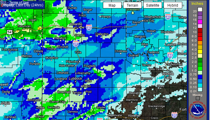
| The maps below show storm rainfall totals as estimated by the NWS Doppler radar at the Lubbock International Airport and as measured by the West Texas Mesonet stations during the event. The maps indicate that the heaviest rains fell to the south and west of Lubbock where between one to two inches of rain fell. The highest amount was observed at the Denver City mesonet where 2.21" of rainfall occurred. Many sites across the South Plains and lower Rolling Plains recorded between one half to one inch of rainfall, while locations along the Southern Panhandle and northern Rolling Plains were slightly lower as between one quarter to one half an inch was generally observed in those areas. The Lubbock Airport officially received 0.73 inches for the event, bringing the yearly total there to 2.74 inches!
|
| Bias adjusted radar estimated 24-hour rainfall totals ending at 5 pm CDT on September 15, 2011. |
|
|
| Storm total rainfall (in inches) ending at 7am CDT on September 16, 2011. The data is courtesy of the West Texas Mesonet. Click on the image for a larger view. |
| Perhaps just as notable as the rainfall, were the very abnormally low temperatures observed in wake of the frontal passage, as much cooler Canadian air oozed into the area thanks to prevailing north to northeasterly winds. In fact, the combination of this cool air and lingering cloud cover through most of Thursday kept temperatures in the 50s - about 25-30 degrees below seasonable averages. This was a definite change from what we have been experiencing for most of the year! In fact, those readings were the lowest high temperatures the area has experienced since the weekend of May 1-2. |
|
|
| Temperatures observed at 3 pm CDT on September 15, 2011. Note that the mercury failed to climb above 60 degrees across a vast majority of the region! These readings represented late autumn-like temperatures, about 25-30 degrees cooler than what the region normally experiences in mid-September! The data is courtesy of the West Texas Mesonet. Click on the image for a larger view. |


.jpg)


 Follow us on YouTube