|
|
2012:
WEATHER OF WEST TEXAS
|
|
|
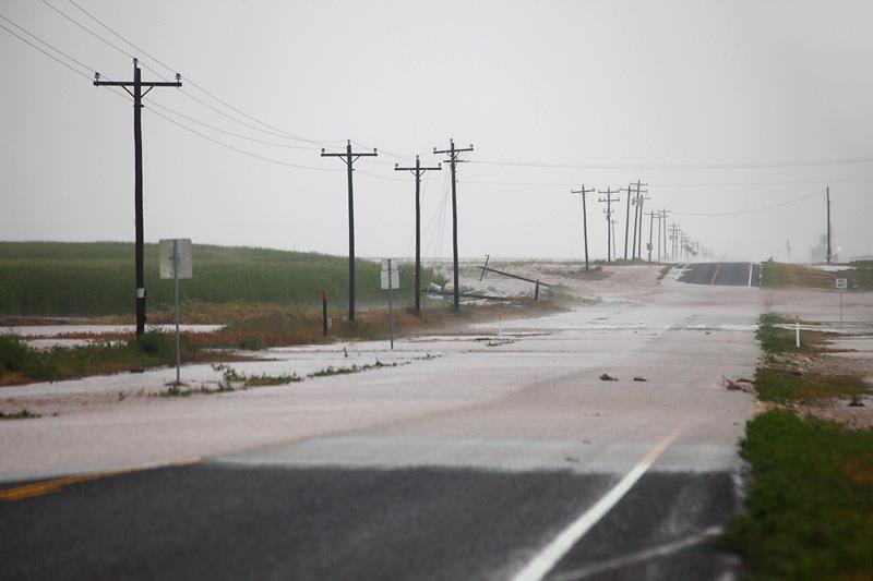
Flooding and damage southwest of Dimmitt-
20 August 2012
|
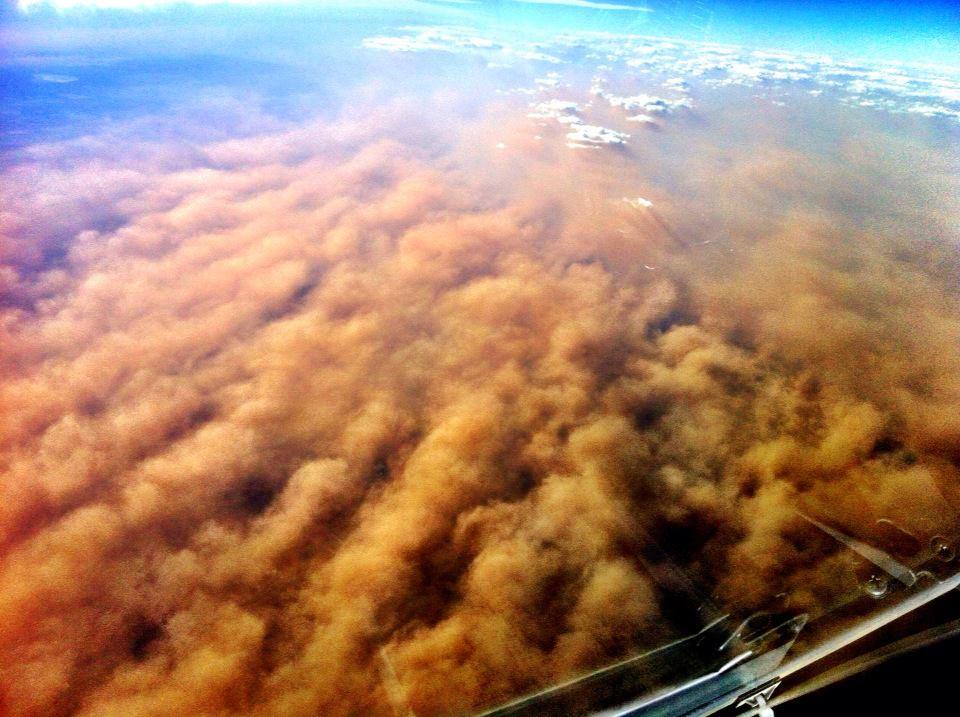
Dust storm as viewed from above (by Chris Manno) -
19 December 2012 |
|
The year of 2012 will go down as one of the warmest and driest years on record in West Texas. In fact, although the summer was not as hot as in 2011, the year in its entirety will go down as the warmest year on record at both Lubbock and Childress. While precipitation amounts improved from 2011, they remained below the long-term average for most locations and were not sufficient to bring an improvement in the drought conditions across the South Plains. The South Plains area was not suffering alone with the warm and dry weather. According to the National Weather Service, the 2012 drought was the most extensive drought to affect the U.S. since the 1930's; drought conditions affected more than half the country for a majority of 2012. Additionally, 2012 was the warmest year on record for the lower 48 states.
Despite the persistent drought, the region saw less wildfires and acres burned than in 2011. This is likely due in part to the reduction in the coverage of vegetation, or "fuel" for fires, due to the dry conditions. However, the area saw an increase in the frequency and intensity of dust storms as the same conditions which reduced the wildfire danger resulted in more exposed topsoil available to be lofted by the wind. The dust storms culminated in the longest duration dust storm in decades (as measured at Lubbock) for the South Plains on December 19th.
Thunderstorm activity and severe weather was sporadic in 2012. The typically active months of April, May and June were on the quiet side, while the fall season was somewhat more active than usual. Although severe weather days were fewer in 2012, we still saw a number of significant episodes, including, for example, a dangerous supercell storm with wind-driven hail across southwest Lubbock County on April 29th, and flooding rains in Caprock Canyons State Park on September 26th. The monthly sections below explore these interesting events and more in greater detail.
Finally, 2012 closed out with an oddity, a back-to-back white Christmas for portions of the South Plains. According to the record book at Lubbock, this was the first such occurrence since 1947/1948.
|
|
|
|
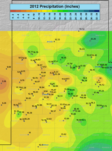
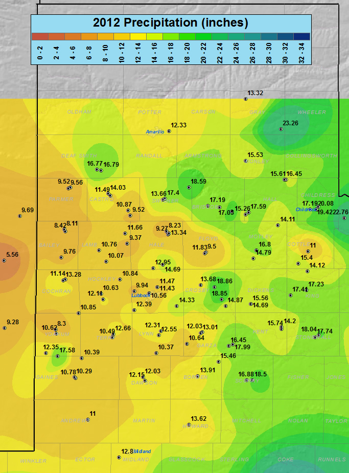
This map displays the 2012 year precipitation totals. The map was created with data gathered from the NWS Cooperative observers and the West Texas Mesonet. Click on the map to view a full-sized version.
|
The above map shows that the 2012 yearly rainfall totals were fairly close to ten inches across much of the Caprock. However, there were a couple of exceptions, including in excess of 16 inches in and around Hereford and over 17 inches in Denver City. Locations off the Caprock generally fared better, with rainfall totals of 15 to 20 inches common. The exception to this was in Paducah where a paltry 11 inches fell. Regional yearly rainfall extremes varied from 5.56 inches at Dora, New Mexico, to 23.26 inches in McLean. The 2012 extremes for the Lubbock NWS area of responsibility ranged from 8.11 inches in Muleshoe to 20.08 inches in Childress.
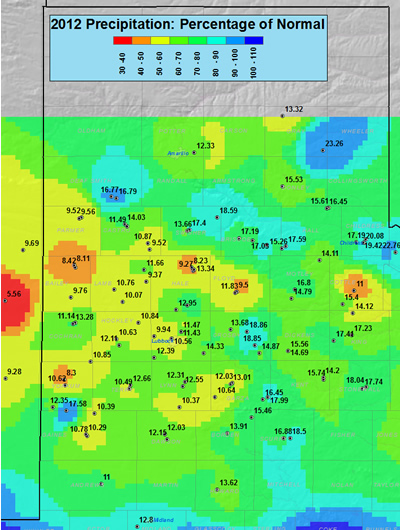
The graphic below displays the percentage of precipitation that fell in 2012 versus an average year. Precipitation on the South Plains generally ranged between 40 and 70 percent of normal in 2012, while totals in the Rolling Plains were mostly between 60 and 90 percent of average.
|
|
| This map shows the 2012 rainfall as a percent of the 30-year normal rainfall (1971-2000). Also plotted is the rainfall observed, in inches, at each collection site. Please click on the map to view a full-sized version. If you would like to see the precipitation as a departure from normal please CLICK HERE. |
Below are some statistics from 2012 for Lubbock:
The year of 2012 will go down in the books as the warmest year on record. This comes on the heels of 2011, which produced the driest and second warmest year on record. The warmth came in a little different form than 2011, starting early, with January averaging 4.2 degrees above average. February briefly interrupted the warmth, finishing 0.6 degrees below average, but much above normal temperatures then developed in March and persisted through the remainder of the spring. The summer was also above average, though not nearly as hot as the summer of 2011. Still, Lubbock did record 24 100-degree days, well above the long term average of 10 days, but considerably under the record of 48 days set the previous year. The fall brought a mixed bag, with September slightly warmer than average, October slightly cooler than average and November much warmer than normal. Much of December was also on the mild side, though it did close out with a chilly last week of the year.
The hottest temperature of 2012 was 105 degrees, recorded on August 2nd. On the other end of the spectrum, the coldest temperature of the year was 11 degrees, observed on December 10th. Given that 2012 was the warmest year on record it may not be a surprise that it also brought the earliest last freeze on record, occurring on February 24th. However, Lubbock also had one of the earliest first freezes on record when the mercury dipped to exactly 32°F on October 8th, just one day short of the all-time record (which occurred in 1952).
Precipitation in 2012 was much more consistent than the record dry year of 2011, with each month recording measureable precipitation, and all but four months receiving over 1/2 inch. Still, only two months (August and September) measured over 2 inches of rainfall. The yearly rainfall total was nearly double that of 2011, but it still came up over 7 inches shy of average. These large precipitation shortages allowed the drought that developed in 2011 to persist through 2012, with only minor improvements in some spots.
Fourteen record highs were tied or set in 2012: 91 degrees on March 29th; 104 degrees on April 25th; 96 degrees on May 1st; 97 degrees on May 2nd; 98 degrees on May 3rd; 99 degrees on May 5th; 102 degrees on May 25th; 105 degrees on August 2nd; 99 degrees on September 7th; 93 degrees on October 20th; 85 degrees on November 2nd; 78 degrees on November 29th; 81 degrees on November 30th; and 79 degrees on December 1st. One record low was tied in 2012 when the mercury fell to 26 degrees on October 27th.
|
LUBBOCK
|
Average High
|
Average Low
|
Precip (inches)
|
|
January
|
60.9
|
28.0
|
0.01
|
|
February
|
57.4
|
30.3
|
0.57
|
|
March
|
74.2
|
42.5
|
0.71
|
|
April
|
|
51.4
|
1.03
|
|
May
|
86.9
|
59.5
|
1.33
|
|
June
|
93.9
|
67.1
|
1.60
|
|
July
|
94.8
|
69.2
|
0.26
|
|
August
|
94.0
|
67.8
|
2.91
|
|
September
|
85.0
|
60.3
|
2.04
|
|
October
|
74.8
|
46.5
|
0.28
|
|
November
|
71.2
|
39.0
|
0.01
|
|
December
|
58.0
|
27.9
|
0.68
|
|
Annual
|
77.9 (3rd warmest)
|
49.2 (warmest)
|
11.43
|
|
Normal
|
74.3
|
|
19.12
|
|
Departure
|
+3.6
|
+2.2
|
-7.69
|
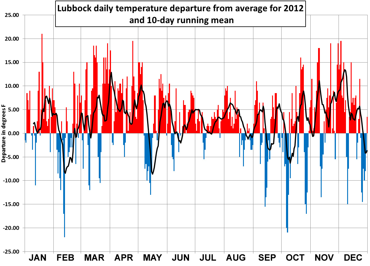
The top portion of the below graph shows the daily high and low temperature distribution for 2012 at Lubbock Preston Smith International Airport. Aside from several short stretches of below average temperatures scattered throughout the year, most of the remainder of the year is marked by temperatures at or well above normal, with many instances of high temperatures near or at record levels. However, the hottest part of the year, from June through August, wasn't exceptional hot like in 2011 and only produced one record high (tying the record high of 105 degrees on August 2nd). Even though the summer wasn't the scorcher that 2011 was, the year, as a whole, did sum to be the warmest on record (which date back to 1911).
|
|
| (Top) Plot of the maximum and minimum temperatures (connected by a black line) observed at the Lubbock Preston Smith International Airport in 2012. Also plotted are the respective normals (green - range of average highs and lows) and record highs (red) and record lows (blue) for each date. Units are in degrees Fahrenheit. (Bottom) Plot of the rain accumulation (green), in inches, observed at the Lubbock Preston Smith International Airport in 2012. Also plotted is the distribution of the average rainfall (brown). Click on the graph for a larger view. |
The lower portion of the above graph shows that precipitation lagged the average throughout the year, though it was fairly consistent (for a semi-arid region). The exceptions to the semi-regular rain in 2012 occurred through the middle of summer, from mid-June through mid-August, and from mid-October through the end of the year, when precipitation was more difficult to come by. The heaviest single day rainfall in the year happened on August 17th, when a thunderstorm brought 1.16 inches. This was the only day the Lubbock Airport recorded an inch or more. Four other days in 2012 measured precipitation totals between 1/2 and 1 inch. The yearly total of 11.43 inches finished as the 9 driest on record.
|
|
| The graph above shows the average daily temperature and 10-day running mean (black line) of at Lubbock as a departure from the 1981-2010 normals. Click on the graph for a larger view. |
The above graph shows the departure of the average daily temperature at Lubbock from the 30-year average. A 10-day running mean is used to smooth out the individual daily fluctuations. This graph clearly illustrates how 2012 ended up being a record-setting year!
|
|
2012 EXTREME WEATHER EVENTS
|
|
Severe hail damage southwest of Lubbock -
29 April 2012
|
Supercell thunderstorm west of Childress -
30 May 2012
|
2012 saw an uptick in severe weather events in comparison to the hot and incredibly dry 2011. In addition to a few bouts of winter weather on the edges of the year, the region did see several rounds of severe weather.
Additionally, 9 tornadoes were observed across the Lubbock County Warning Area (CWA) in 2012. All of these tornadoes were brief and did no known damage. Four of the tornadoes were of the landspout (non-mesocyclone) variety. The first tornadic storm of 2012 occurred on April 28, when a chaser documented a brief tornado about 14 miles southwest of Aspermont. May 30th brought the four brief landspout tornadoes near Paducah, with an additional tornado west of Paducah later that evening. A thunderstorm produced a brief tornado a couple of miles west-northwest of Crosbyton on June 4th. Finally, a supercell thunderstorm produced a couple of brief tornadoes in east-central Hale County on the evening of October 12th.
|
|
|
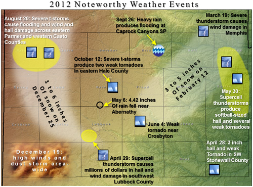
Map displaying many of the more notable weather impacts to the region in 2012. Click on the image for a bigger view.
|
MONTHLY 2012 HIGHLIGHTS:
9th: A winter storm brought heavy snow to extreme southeast New Mexico and the Permian Basin, with lighter snow falling across the southern South Plains. Up to a foot of snow fell from Hobbs to Midland, with lighter amounts further north. Lubbock, Brownfield and Lake Alan Henry recorded between one and two inches, while Plains had 2.2 inches and Denver City recorded 7 inches. To learn more about this event CLICK HERE.
22nd: A dynamic storm system produced strong and severe winds which in turn lofted copious amounts of blowing dust across the region. Wind gusts generally peaked between 60 and 70 mph across the northern South and Rolling Plains into the southern Panhandle. A top wind gust of 77 mph was recorded at Clarendon, where showers further enhanced the already impressive winds. Read more about this windy and dusty day HERE.
2nd: A line of thunderstorms brought hail up to 1 inch in diameter to Dimmitt during the evening hours.
12-13th: An upper-level storm system brought widespread snow to the region for St. Valentine's weekend. Snow totals of 1 to 3 inches were common across most of the area with isolated 4 to 5 inch amounts around Floydada and Crosbyton as well as in and around Childress. To read a more complete summary CLICK HERE.
20th: A strong winter storm generated strong to severe wind gusts and bountiful amounts of blowing dust during the afternoon hours. A peak wind gust of 63 mph was recorded east of Silverton, though most places saw wind gusts between 50 and 60 mph. A summary of this wind event can be FOUND HERE.
28th: Another round of strong winds and blowing dust visited West Texas. The strongest winds, from 55 to 60 mph, were focused across the central and western South Plains and southwest Texas Panhandle. The warm, dry and windy conditions also supported a couple of wildfires including one that burned 375 acres near Sudan. A detailed explanation of this event is AVAILABLE HERE.
8th: A cold front brought strong to severe wind gusts in its wake during the morning, including a gust to 60 mph in Cochran County. Heavy sleet then developed behind the front during the afternoon across the central and eastern South Plains. Up to 2 inches of sleet fell in Garza County on U.S. Highway 84, causing numerous traffic accidents.
16th: Isolated strong and severe thunderstorms developed late in the afternoon. Hail to the size of quarters was reported 6 miles north of Abernathy near Petersburg.
18-19th: Several severe thunderstorms developed along the dryline in the Rolling Plains during the afternoon hours. Golf ball size hail was reported 10 miles north of Childress and a rapidly rotating wall cloud was observed south of Guthrie. The dryline rapidly retreated during the evening and was then the focus for a line of late night thunderstorms that brought rain to the entire region. Rain totals for the day were heaviest off the Caprock where several spots recorded over an inch. In addition, the squall line generated downburst winds in excess of 70 mph across Memphis which in turn produced numerous instances of mostly minor structural damage there. For details on this severe thunderstorm event VISIT THIS PAGE.
9th: A thunderstorm damaged power poles as it moved across northeast Childress County.
14th: A powerful storm system brought strong winds and blowing dust during the day. A line of thunderstorms then erupted when a retreating dryline collided with an advancing Pacific cold front. The storms dumped up to golf ball size hail across parts of Lubbock. To learn more about this day CLICK HERE.
24th: Isolated very high-based thunderstorms generated several instances of severe downburst winds and blowing dust between Muleshoe and Spade. The winds damages three power poles in southeast Lamb County.
28th: A supercell thunderstorm developed and tracked across the southern Rolling Plains through the evening hours. The storm dumped copious amounts of hail, mostly small, but up to 3 inch diameter in southwest Stonewall County. In addition, the storm produced a brief tornado over open land in southwest Stonewall County near sunset. Later that night new storm development brought golf ball size hail near Memphis.
29th: A particularly intense supercell thunderstorm produced baseball to softball size hail, winds in excess of 80 mph, and torrential rains across parts of southern Lubbock County. The combination of wind and hail caused extensive damage to vehicles and structures. A full summary of this event can be found HERE.
30th: Another round of severe thunderstorms developed, this time affecting the southeast South Plains into the Rolling Plains. Hail as large as baseballs was observed near Dickens and Post.
3rd: A severe thunderstorm developed along the dryline over Stonewall County during the early evening hours. This storm dropped golf ball size hail in Aspermont before moving east.
7-14th: After a toasty start to the month, the second week of May brought cooler and wetter weather to the region. Many spots on the Caprock record 1-2+ inches over the week long period, with generally lighter amounts in the Rolling Plains. A summary of this week can be found HERE.
20th: An isolated thunderstorm dumped hail up to the size of tennis balls along U.S. Highway 83 south of Guthrie during the evening.
30th: Several intense rotating thunderstorms developed across the southeast Panhandle during the late afternoon and moved into the Rolling Plains through the evening hours. These storms generated very large hail, damaging winds, and isolated tornadoes. Spots north and northeast of Paducah saw golf ball to baseball size hail. Severe downburst winds damaged barns, trailers and a home near Plaska and knocked down trees and power lines and damaged homes and vehicles around Paducah. In addition, four brief non-mesocyclonic tornadoes were observed near Paducah, while another tornado tracked over open country west of Paducah. CLICK HERE for a complete summary of this severe weather event.
early June: Rounds of showers and thunderstorms dumped heavy rain in spots. The heaviest rains fell in a north-northwest to south-southeast swath across parts of the South Plains on the 6th, when a few locations received over 4 inches of rain. In addition, severe storms on the 4th dumped golf ball size hail west of Floydada and produced a brief tornado just west of Crosbyton. To read more CLICK HERE.
12-17th: Mid-June brought active weather in the form of periods of showers and thunderstorms. Many locations recorded 1-3 inches of rain over the week, with a few spots from near Memphis to Childress getting nearly 5 inches. In addition, an isolated supercell brought baseball size hail near Whiteface during the evening of the 12th. A summary of this week of weather can be found HERE.
8-10th: A rare summer cold front dropped temperatures into the 70s and 80s and was the focus for a few rounds of spotty, though locally heavy, rain. Read more about this cool and wet mid-summer reprieve HERE.
23rd: Scattered strong, slow-moving thunderstorms developed during the afternoon across the South and Rolling Plains. One storm produced a peak wind of 69 mph southwest of Guthrie, while other storms brought heavy rain, from 2-4 inches south of Dougherty and east-northeast of Roaring Springs.
25th: Scattered thunderstorms developed across the area. Although most of the activity was sub-severe, one storm generated a wind gust to 60 mph near Brownfield. Lightning from another storm started a wildfire in Motely County.
20th: Scattered strong and severe thunderstorms unleashed heavy rains, damaging downburst winds and large hail across the southwest Texas Panhandle during the early evening hours. One particularly intense storm snapped power poles and dropped torrential rain southwest of Dimmitt. Another storm produced a wind gust measured to 88 mph near Friona. A large area of thunderstorms then consumed these initial storms and raced southeast, bringing welcome heavy rains for a good portion of the southern Panhandle into northern parts of the South and Rolling Plains. A full write-up on this event can be accessed HERE.
24th: Severe downburst winds from a thunderstorm caused moderate damage to a greenhouse located at Lowe's Home Improvement store in Lubbock during the late evening. Other generally minor damage was observed through parts of Lubbock. Lightning from the storm did strike a corrugated steel natural gas line of a house in south Lubbock. Unfortunately, the ensuing explosion killed one man and caused a second man to be sent to the hospital for smoke inhalation.
5th: Scattered thunderstorms developed across the entire region during the afternoon and evening hours. One storm grew severe and produced a wind gust to 69 mph near Turkey.
12-13th: A cold front and upper level disturbance combined to bring widespread rains to the South Plains region. Many spots saw 1/2-1 inch of rain with localized amounts approaching 2 inches. Details on this rain event can be found CLICK HERE.
26th: A line of thunderstorms swept across much of the South Plains and Rolling Plains during the afternoon and evening hours. These storms produced heavy rain and strong to severe wind gusts. Scattered damage was noted through Lubbock, including at the Panhandle-South Plains Fair, where several vendor tents were torn and bent. Torrential rain caused flash flooding in Caprock Canyons State Park and a rogue wind gust to 96 mph was measured 10 miles southwest of Paducah. To read about this wild weather CLICK HERE.
27th-29th: Tropical Pacific moisture from once Hurricane Miriam joined forces with Gulf of Mexico moisture and upper level storm system to bring widespread rain to the entire state of Texas. The heaviest, flooding rain fell from the Permian Basin in the Concho Valley and points east. However, the South and Rolling Plains did pick up beneficial rains with many spots measuring 1-2+ inches over the course of a few days. Read more about these tropical rains HERE.
8th: A strong cold front brought much below normal temperatures to the region. Lubbock officially recorded a low of 32 degrees, resulting in the second earliest first freeze on record (record is October, set in 1952).
12th: Scattered severe thunderstorms developed across the central South Plains during the late afternoon hours. The most intense supercell thunderstorm produced a couple of brief tornadoes in central Hale County. The tornadic storm also dropped baseball size hail south of Hale Center. A complete story on this event can be VIEWED HERE.
entire month: November was a relatively quiet month weather-wise. The month was marked by unseasonably warmth, finishing over 5 degrees above average. In addition, November was dry, with most spots receiving less than a tenth of an inch of rain for the entire month.
9-10th: An intense but quick moving band of snow dropped a half inch to inch of snow across much for the southwest Texas Panhandle into the South Plains during the late evening hours of the 9th into the early morning hours of the 10th. To read more about the first snow of the season CLICK HERE.
14th: A line of strong and severe thunderstorms raced across the area during the afternoon hours. The squall line generated wind gusts of 50 to 60 mph over a large swath, with several wind gusts over 65 mph, including a gust to 77 mph in Lubbock. Additionally, the line of storms brought brief heavy rains to the entire area, though overall rain totals were rather low given the fast storm motion. Details on this severe squall line can be found by CLICKING HERE.
19th: A strong upper-level storm system brought widespread strong winds (gusts peaking between 50 and 66 mph) and prolonged and suffocating blowing dust to West Texas during the afternoon and evening hours. Read more about this unpleasant day HERE.
25th: A cold front ushered in chilly air just in time for Christmas. In addition, a band of snow developed early Christmas morning and gave many people across the southwest Panhandle into the western and Central South Plains a white Christmas. Snow was more limited in other spots though most locations saw at least a little light snow. Read more the cool and snowy (for some) Christmas HERE.
30-31st: A chilly rain closed out the year, with many spots across the central South Plains receiving around a half an inch of rain late on the 30th into early on the 31st. Details on the cool and wet end to 2012 can be FOUND HERE.


 Follow us on YouTube