|
Winter Storm hits West Texas
21-25 November 2013 |
|||||
 |
|||||
|
Photograph of moderate sleet and snow falling at the Science Spectrum at Lubbock around 1:30 am early Sunday morning.
|
|||||
| After a warm middle stretch of November with afternoon highs in the 60s and 70s common, a strong cold front raced through the South Plains Thursday afternoon (November 21st). The front was accompanied by blowing dust and gusty north winds. Temperatures plummeted behind the front with winter making an abrupt visit to West Texas. Temperatures quickly fell below freezing Thursday night. This shallow front lifted relatively warm and moist air over it and this resulted in the development of scattered freezing rain and sleet showers by early Friday morning. This activity resulted in some slick roadways for the Friday morning commute. In addition, a heavier band of freezing rain developed over parts of the eastern South Plains into the Rolling Plains, with significant amounts of icing occurring there during the day. The heavier wintry precipitation then subsided late Friday, but areas of freezing drizzle continued through much of the night, causing additional travel difficulties as temperatures held in the 20s. Additional sleet and snow showers then developed during the day Saturday, with areas of freezing drizzle also continuing. The photographs below show two different views of blowing dust concentrated along the leading edge of the cold front as it sweeps south Thursday afternoon. | |||||
 |
 |
||||
|
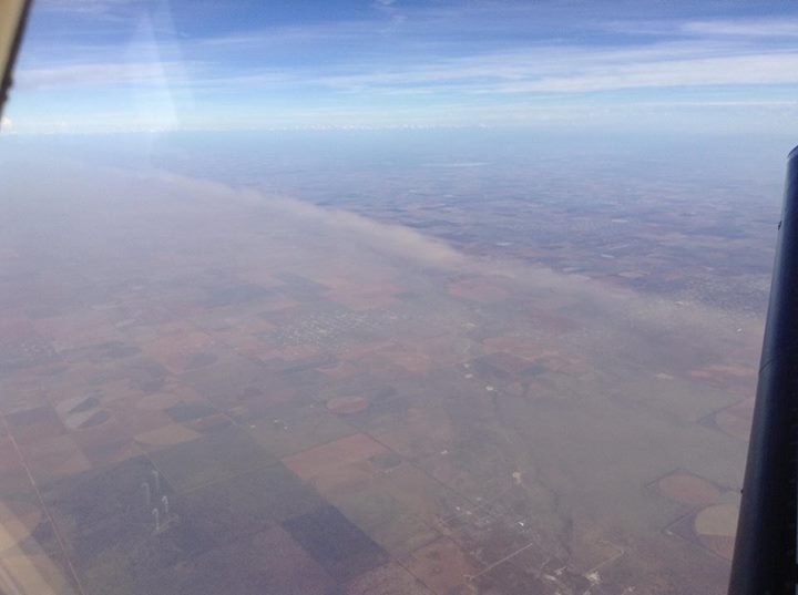
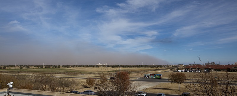
Blowing dust concentrated along the cold front as it passes through the South Plains Thursday afternoon. The left photograph was taken from and plane and is courtesy Louie Hillard. The right image was taken in Lubbock and is courtesy of John Stout. Click on the photos for larger views.
|
|||||
An upper-level storm system then began to approach from the Desert Southwest late on Saturday. Although the center of the storm system was still centered over Arizona, it drew much deeper moisture and lift over West Texas, which resulted in the blossoming of precipitation. A large swath of sleet and snow spread from eastern New Mexico into the western South Plains and southwest Texas Panhandle Saturday evening. The precipitation fell primarily as snow over the higher terrain of northwest Texas, from Happy to Muleshoe and Morton. However, a layer of warm air aloft kept a mixture of sleet and even freezing rain falling at some lower elevations further to the east, from the central South Plains into the Rolling Plains. About a tenth of an inch of ice accumulated in Lubbock, with greater icing in several other spots into the Rolling Plains. The image below shows a snapshot of the upper-level storm system approaching the area. |
|||||
 |
|||||
| Satellite and upper-air map showing the weather pattern responsible for the winter weather. | |||||
| As the precipitation intensified and the warm layer aloft cooled, freezing rain transitioned to sleet and snow. At Lubbock, moderate to heavy snow fell early Sunday morning, with 1.5-3 inches accumulating. The below radar animation shows the large shield of precipitation, mostly in the form of snow and sleet, expanding across northwest Texas late Saturday evening. | |||||
 |
|||||
|
Radar animation valid from 8:58 to 10:08 pm on Saturday, 23 November 2013. |
|||||
| Snowfall amounts were generally lighter to the south and east of Lubbock, but increased significantly to the north and west of Lubbock. A large swath of a half a foot or more of snow fell over the northwest South Plains and southern Texas Panhandle. Happy recorded 10.5 inches, with Friona, Dimmit, Muleshoe and Caprock Canyons reporting 8-9 inches. The image below shows the snow and ice accumulations that we received across the area. | |||||
 |
|||||
|
Map of snowfall totals we've collected from cooperative program observers, city and county officials, and public reports. |
|||||
| The heaviest snow and sleet quickly diminished and shifted to the east Sunday morning, but additional lighter pockets of sleet and snow showers, along with areas of freezing drizzle, persisted. This activity finally tapered off late Sunday, but sub-freezing temperatures provided another morning with slick roadways to kick off the new work week. | |||||
|
|||||
|
Finally, to conclude the prolonged period of winter weather, the parent upper level storm system that provided a lot of the wintry weather moved directly overhead Monday afternoon and evening. By this time the system was lacking in upper level moisture and lift, but it did have just enough low-level moisture to provide one last round of freezing drizzle and flurries Monday evening before accelerating off into central Texas. Here are a few more photographs from around the region during this event: |
|||||
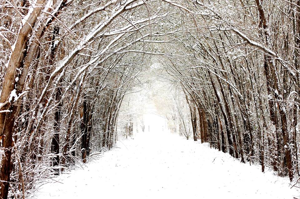 |
| Photograph of snow-covered trees lining a trail at Caprock Canyons State Park and Trailway. About eight inches of snow fell in the park. |
 |
| Photograph of a snow-covered back porch from our Co-op observer in Muleshoe. About eight inches of snow fell in Muleshoe. |
 |
|
Picture of the snow cover, as seen from space, over New Mexico, West Texas, and southwestern Oklahoma. The image was taken by the polar orbiting Aqua satellite on 26 November 2013. The heaviest swath of snow and Palo Duro Canyon are clearly visible.
|
|
|


 Follow us on YouTube