 |
|||||||
 |
|||||||
| Mammatus clouds in advance of strong to severe thunderstorms on Friday evening, 6 June 2014. This picture was captured near Denver City and is courtesy of KCBD. | |||||||
| [Updated June 10th for damage survey in the Muleshoe and Sudan area] Early June brought more typical spring-like weather to the South Plains of West Texas, including several rounds of severe weather along with locally heavy rainfall. This active stretch of weather was aided by plentiful amounts of Gulf of Mexico moisture along with several weak passing upper level disturbances. Unfortunately, the more intense storms did produce very large hail and damaging winds in some spots, but many locations did receive beneficial rainfall too. |
|||||||
 |
|||||||
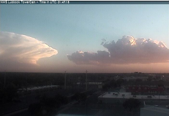
| Storm near Denver City on the evening of June 5th (Thursday), as viewed from Lubbock. Developing clouds are also visible just west of Lubbock | |||||||
|
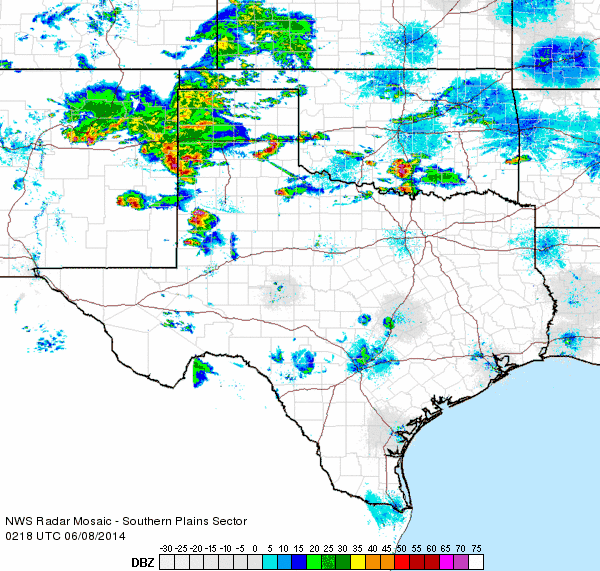
The active stretch of weather began modestly, on June 5th, we one lone thunderstorm moved into the extreme southwest South Plains during the evening hours (seen above). This storm brought lightning and a little bit of rain around the Denver City area, but then quickly collapsed, producing a wind gust as high as 77 mph near Brownfield. These strong winds did down a few power poles near Brownfield. More widespread severe thunderstorms then developed across the higher terrain of eastern New Mexico the next afternoon. This activity then merged into a complex and tracked eastward into the South Plains and Texas Panhandle Friday evening and overnight (seen below). This round of storms brought with it large hail and damaging outflow winds. Hail as large as golf balls was observed near Farwell, and a wind gust to 72 mph was measured by the West Texas Mesonet site 2 miles northeast of Dimmitt. Strong to severe winds raced across much of the southern Texas Panhandle and northern South Plains. These intense winds did down power poles and trees in several locations, including in and around Muleshoe, Levelland and Caprock Canyons State Park. |
|||||||
 |
|||||||
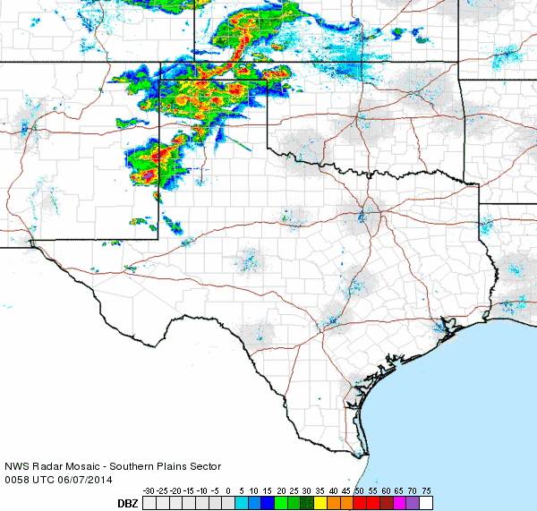
| Regional radar animation valid from 7:58 to 9:08 pm on 6 June 2014. | |||||||
|
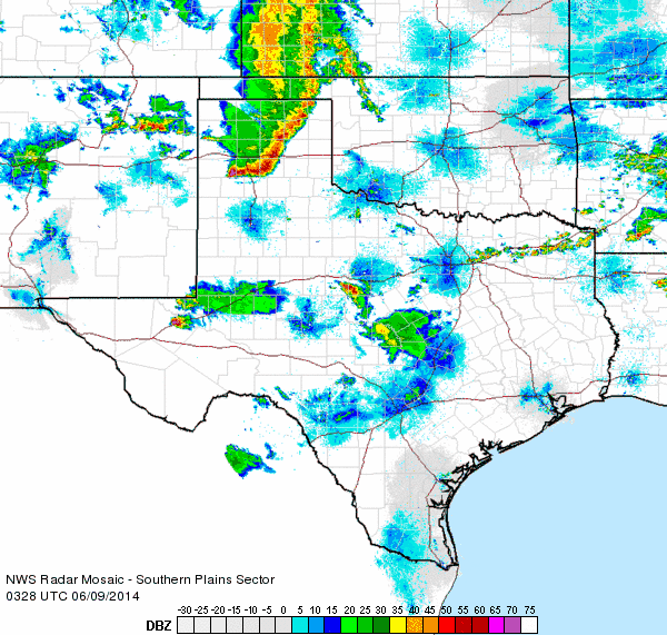
The episodes of severe weather peaked on Saturday (7 June 2014). A lone severe supercell (rotating) storm developed during the afternoon hours across the northeast South Plains and tracked slowly eastward into the Rolling Plains. This first storm of the day was a proficient hail producer, with many spots from near the community of South Plains to Matador receiving golf ball sized hail. Hail as large as baseballs was reported in Cedar Hill. This initial storm eventually diminished during the mid-evening hours, but it was only a precursor of things to come. Much more widespread thunderstorm activity then developed to the west and moved into the South Plains region. Many of these storms were rotating and produced very large hail, along with strong winds and torrential rainfall. Hail from golf ball to baseball size fell in many locations, and in combination with winds of 60 to 80+ mph, this caused significant damage. |
|||||||
 |
|||||||
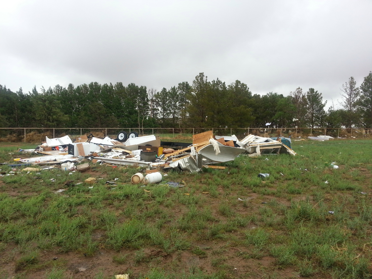
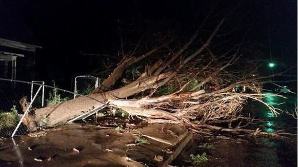
| Trailer that was rolled and destroyed southwest of Wolfforth during the late evening hours of 7 June 2014. | |||||||
| A peak wind gust of 96 mph was measured with one storm as it moved over a West Texas Mesonet site 6 miles south-southwest of Wolfforth at 11:30 pm. These winds damaged or destroyed several trailers, including the one pictured above. The large hail also damaged many vehicles, including the one pictured below that was smashed near Sundown. | |||||||
 |
 |
||||||
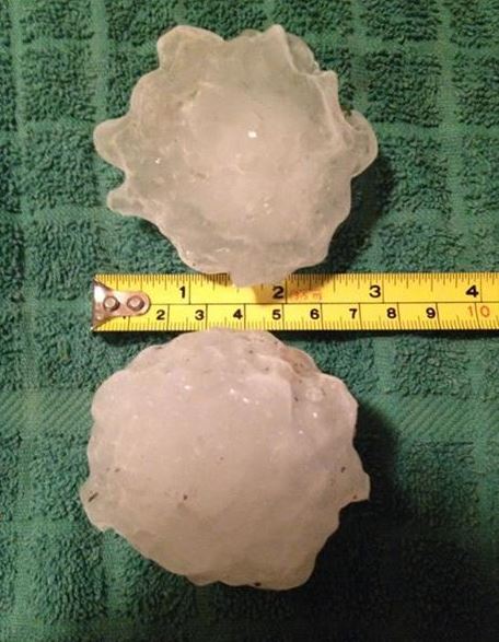
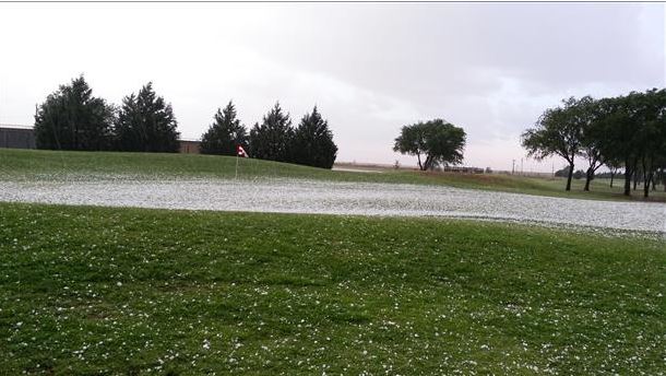
| Images of hail (left) and hail damage (right) near Sundown that occurred on the evening of 7 June 2014. The pictures are courtesy of KCBD. | |||||||
| The following radar animation shows how the thunderstorm activity evolved Saturday evening. The various storm motions are due to several factors, including the strength and direction of rotation of the individual storms. Because of the differential motions, several storms interacted with each other, often resulting in very heavy rainfall in addition to the severe weather. | |||||||
 |
|||||||
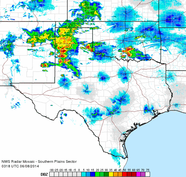
| Regional radar animation valid from 9:18 to 10:28 pm on 7 June 2014. To view an additional radar animation valid from 10:18 to 11:28 pm CLICK HERE. | |||||||
| Below are several images captured during or after all of the wild weather Saturday evening/night. Unfortunately a lot of minor to moderate damage did occur around the region, mostly a result of wind driven hail. We did also receive one report of a tornado near Sudan around 10 pm. Although this tornado has not been verified, a very intense storm did produce damage between Muleshoe and Sudan, as the final series of images below shows. | |||||||
|
|||||||
| (Left) Baseball sized hail that fell south of Lubbock on 7 June 2014. The picture is courtesy of J.R. Tate and KCBD. (Center) Wind driven hail damage to a home located southwest of Lubbock. (Right) Wind driven hail damage that occurred on 7 June 2014. The exact location of this damage is unknown. The picture is courtesy of KCBD. | |||||||
|
|||||||
| (Left) Hail falling in Denver City during the evening of 7 June 2014. (Center) Tree that was uprooted in Lockney. (Right) A picture of lightning captured Saturday night (7 June). The above images are courtesy of KCBD. | |||||||
|
|||||||
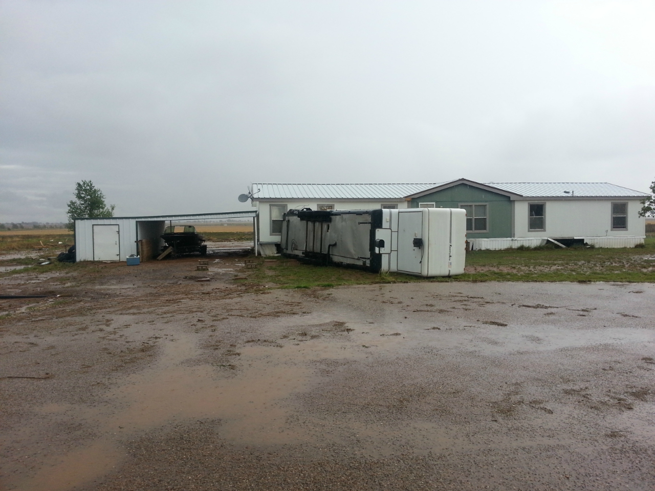
| (Left) Power poles knocked down near FM 784 in Hale County. Picture courtesy of KCBD. (Center & Right) Trailers that were flipped by strong thunderstorm winds southwest of Lubbock on 7 June 2014. | |||||||
|
|||||||
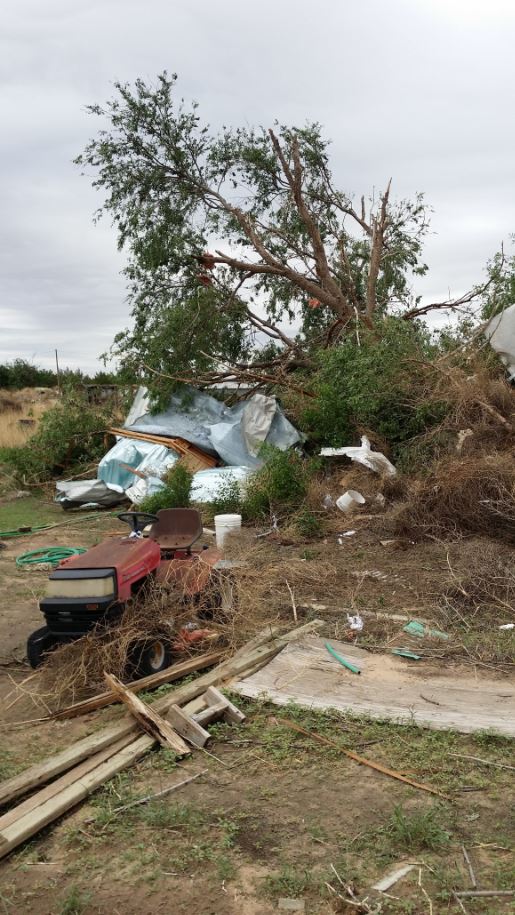
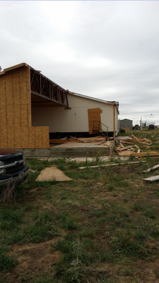
| Damage that occurred near Highway 84 between Muleshoe and Sudan late Saturday evening (7 June 2014). The images are courtesy of Roy Rice. | |||||||
| Scattered non-severe thunderstorms then redeveloped over portions of the South and Rolling Plains Sunday morning and early afternoon. This activity brought additional light to moderate rainfall at several locations. Then, one final round of strong to occasionally severe thunderstorms developed late Sunday night (8 June 2014) and plunge southeastward over much of the region through early Monday morning. This activity was less intense than the previous nights, but did drop quarter size hail west of Floydada and produced several wind gusts of 50-60+ mph as it rolled through. | |||||||
 |
|||||||
| Regional radar animation valid from 10:28 to 11:38 pm on 8 June 2014. | |||||||
| As is often the case, the extended bouts of severe weather were not all bad. In fact, over the course of the 4+ day stretch from Thursday through early Monday (5-9 June), most locations received beneficial rainfall. As the below map shows, many spots picked up an inch or more of rainfall, with 2+ inches measured in many rain gauges. Mackenzie Reservoir, near Silverton, even rose almost 10 feet thanks to the runoff from the heavy rain. | |||||||
 |
|||||||
| Radar estimated 5-day precipitation totals for the South Plains region, ending midday on Monday 9 June 2014. | |||||||
|
The preliminary storm reports for this active stretch of early June weather can be found by clicking on the below links: |
|||||||
| Friday, 6 June 2014 | Saturday, 7 June 2014 | Sunday, 8 June 2014 | |||||
|
Plots of a storm survey, conducted by the NWS in Lubbock, as well as rainfall totals and preliminary storm reports, can be viewed in the map below. June 10th Update: A storm survey was also conducted for damage in the vicinity of U.S. Highway 84 near Muleshoe. Click HERE to view the results of this survey. |
|||||||
|
|
|||
|
Toggle storm survey for June 7, 2014, storms. Click on each point for details and pictures.
|
Toggle 4-day rainfall totals (inches) ending midday Monday (June 9, 2014)
|
Toggle 24-hour rainfall totals (inches) ending at 7 am Sunday (June 8, 2014)
|
|
|
Toggle Preliminary Storm Reports for Friday, June 6, 2014
|
Toggle Preliminary Storm Reports for Saturday, June 7, 2014
|
Toggle Preliminary Storm Reports for Sunday, June 8, 2014
|
|


 Follow us on YouTube