|
National Weather Service Lubbock Significant Weather Events
May 22-23, 2016: Severe storms bring tornadoes,
huge hail and torrential rainfall |
|
|
|
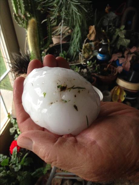
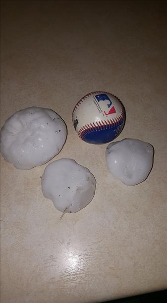
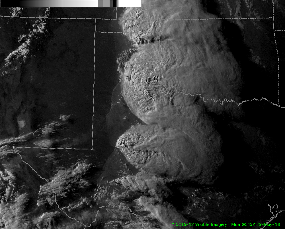
As though on cue, the weather over West Texas took a violent turn as we moved toward the historical peak of severe weather season for the region. Isolated severe storms developed as early as Saturday evening (May 21st) when the dryline sparked a few thunderstorms over the region, though the South Plains was largely unscathed. That changed dramatically the next day as storms again erupted along and ahead of the dryline, but became much more widespread as they spread across portions of the Rolling Plains and eastern Texas Panhandle. One particular intense storm moved near Grassland and Post, dropping baseball to softball sized hail as it did so. Below you can view a few of the pictures of the very large hail that fell in parts of Garza County on the evening of the 22nd. |
|
  |
|
The storms generally moved northeastward dropping large hail and heavy rains as they did so. The exception to this was an intense storm that dropped anchor over portions of Hall County and just sat there much of the evening. In addition to dropping very large hail, this nearly stationary storm produced torrential rainfall that resulted in flash flooding. |
|
|
|
The storms were not only hail and rain producers, but they generated strong to severe winds. The West Texas Mesonet site in Ralls recorded at wind gust to 65 mph, which toppled several power poles just west of town. Severe wind gusts also blew over a number of trees in in Floydada and blew a roof off a barn south of Turkey. |
|
|
|
Even west of where the storms tracked, strong outflow winds pushed into the central South Plains, complete with blowing dust too. The above images show what the blowing dust looked like (at ground level and from space) as the strong outflow pushed through the Lubbock area. |
|

|
|
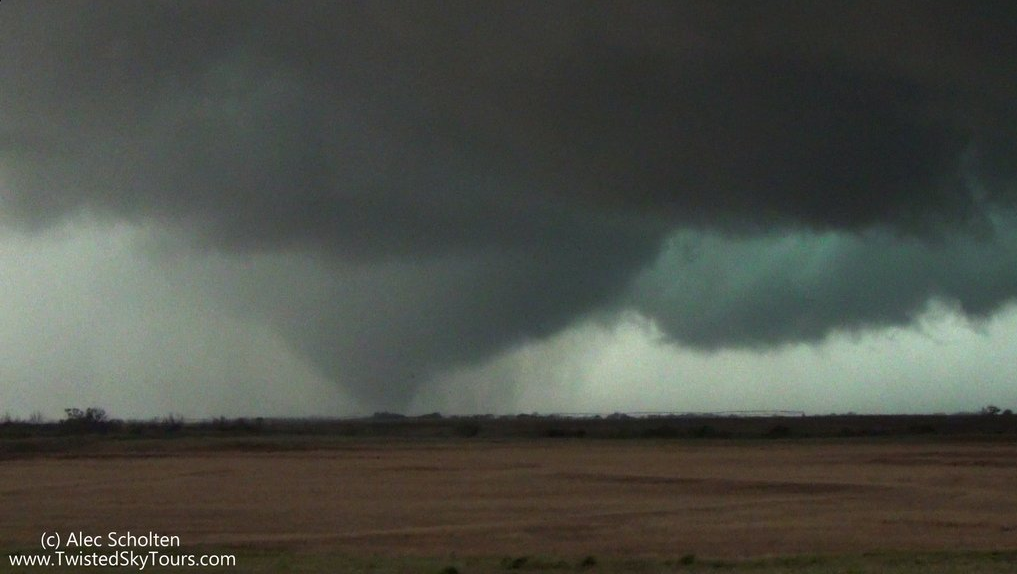
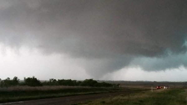
Not to be outdone, the nearly stationary and strongly rotating storm in Hall County further intensified and produced a tornado just south of Lakeview around 6:44 pm. The tornadic storm continued in some form or fashion until shortly after 7 pm on the 22nd. |
|
|
|
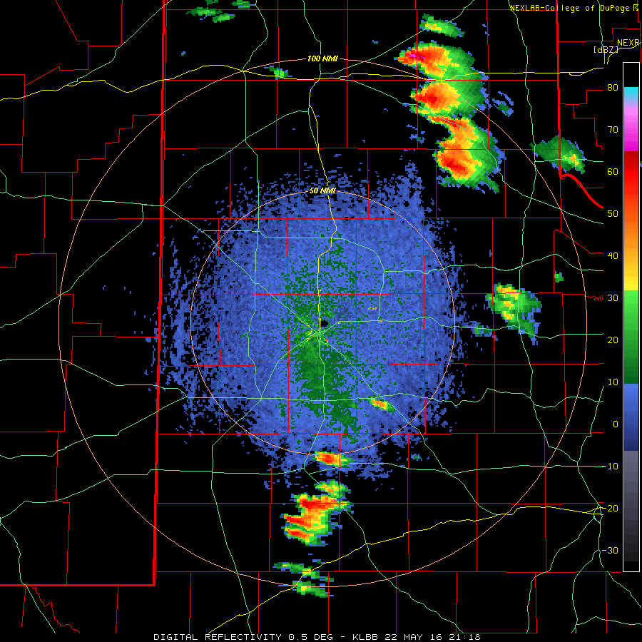
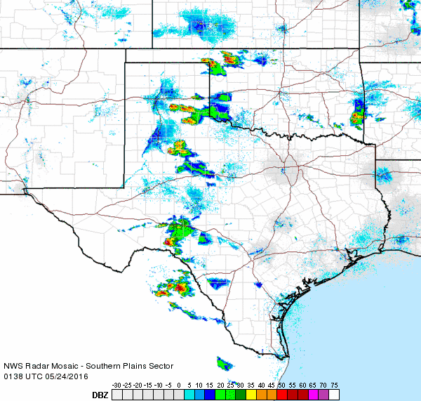
The below radar animation shows the tornadic storm in the far southeast Texas Panhandle, with other strong and severe storms increased in coverage as they approached the tornadic storm from the south. |
|

|
|
Most of the damage from the tornadic storm occurred to center pivots and trees. Although difficult to ascertain due to limited damage indicators over relatively open terrain, a damage survey concluded that the tornado travelled roughly from near Plaska to about 8 miles west of Estelline. The survey team also concluded that the damage was likely caused by several tornadoes that would develop, touchdown and then dissipate rather than one long-track tornado. |
|
|
|
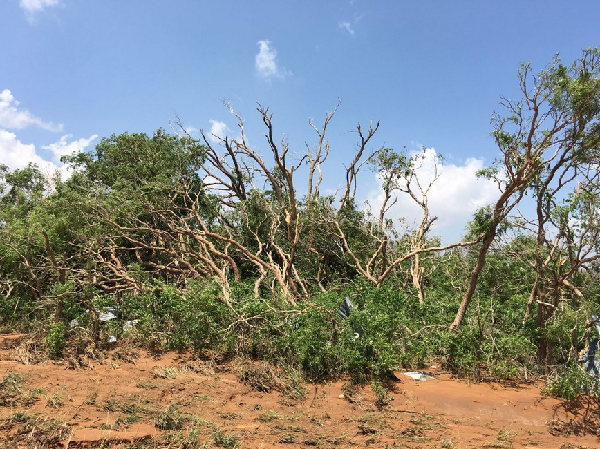
Thankfully, the tornado(es) remained over open land and did not cause any injuries or fatalities. Straight line winds associated with the tornadic storm did down around a dozen utility poles and destroy a barn west of Estelline. |
|
|
|
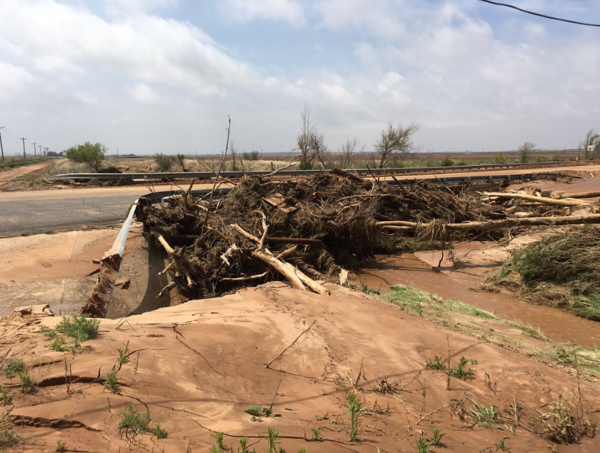
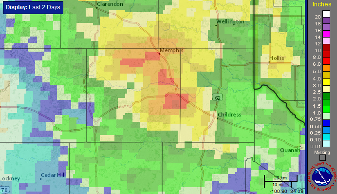
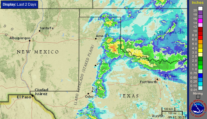
The most widespread and destructive impact from this slow-moving severe thunderstorm was the flooding rains it produced. Rainfall totals of 3 to 5+ inches were common over a large portion of Hall and western Childress Counties (see the below map), with one report up to 8 inches of rain received from just south of Estelline. The extreme runoff flowed down normally dry washes and swelled streams and creeks. The floods damaged or destroyed several bridges and roadways, and led to high-water rescues near Lakeview (west of Memphis). |
|
|
|
A tremendous amount of runoff quickly fed into the Prairie Dog Town Fork of the Red River which flows north of Childress. The river gauge located 10 miles north of Childress (seen below) showed a rapid rise to just above minor flood stage by early the next morning (23 Monday 2016), though the river level fell nearly as fast and was close to base flow by late Monday. |
|

|
|
After a brief reprieve Monday morning and early afternoon, scattered severe thunderstorms redeveloped during the afternoon and evening hours. The thunderstorm coverage on Monday was less than the previous day, but the most intense storms affected some of the same locations in and near Hall County. |
|
|
|
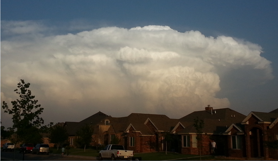
The storms that did form fed on strong instability and grew to be quite tall and picturesque, at least from a distance. These storms dropped large hail in spots including golf ball size hail in Petersburg and Silverton. |
|
|
|
One particularly intense and slow-moving storm again developed in the southeast Texas Panhandle, this time across northern Motley into southern Hall Counties. Initially this storm generated large hail and very heavy rain through the mid-evening hours. |
|

|
|
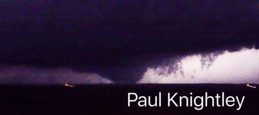
Things then changed during the late evening hours as the storm interacted with another that approached from the southeast and eventually merged with it. Rotation quickly increased and intensified and a tornado formed around or shortly after 9:30 pm. Even with limited lighting after dark, several storm spotters were able to confirm a large tornado over rural country. The tornado, which was initially nearly stationary for a few minutes about 10 miles west of Northfield, then moved slowly northwestward toward Turkey before finally dissipating about 2 miles east of Turkey shortly after 10 pm. |
|
|
|
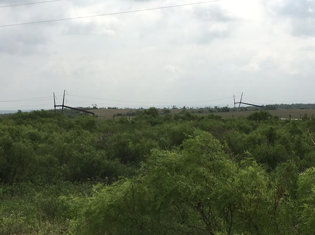
Damage indicators were sparse in this part of Hall County as it affected open ranch and canyon land to the southeast of Turkey. However, several large steel pylons supporting electrical lines were bent to the ground by the tornadic winds, as seen below. This damage was used to conclude that the tornado had winds in the 135 to 140 mph range which puts it in the lower end of the EF-3 range. A complete report of the preliminary damage survey results for the 23 May 2016 tornado event near Turkey, Texas, can be VIEWED HERE. |
|
|
|
In addition, a text listing of the preliminary storm reports for the active couple of days can be viewed at: May 22, 2016 and May 23, 2016. |
|


 Follow us on YouTube