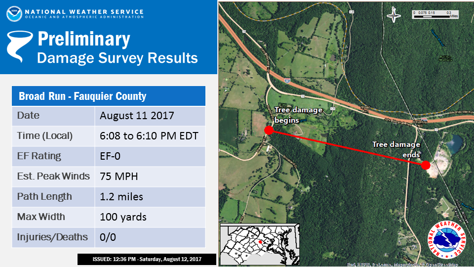
...Brief Tornado Confirmed Near Broad Run in Fauquier County
Virginia...

Location...Broad Run in Fauquier County Virginia
Date...August 11 2017
Estimated Time...608 to 610 PM
Maximum EF-Scale Rating...EF0
Estimated Maximum Wind Speed...75 MPH
Maximum Path Width...100 YARDS
Path Length...1.2 MILES
Beginning Lat/Lon...38.8222 N / 77.7330 W
Ending lat/Lon...38.8183 N / 77.7079 W
* Fatalities...0
* Injuries...0

* The information in this statement is preliminary and subject to
change pending final review of the event(s) and publication in
NWS Storm Data.

...Summary...
The National Weather Service in Baltimore MD/Washington DC has
confirmed a brief tornado near Broad Run in Fauquier County Virginia on
August 11 2017.

Numerous trees were uprooted and large branches snapped along a
1.2-mile long path that paralleled John Marshall Highway just to
its south. Some trees fell on power lines and homes. The tornado
touched down as the circulation crossed Blantyre Road between
Trapp Branch Road and Georgetown Road, then tracked east and
lifted two minutes later shortly after crossing Beverly's Mill
Road a quarter mile south of John Marshall Highway.

KLWX Doppler Radar and FAA Terminal Doppler Radars showed a
rotating supercell with a classic hook echo signature crossing
these areas between 608 and 610 PM. Tree damage showed a
convergent signature, implying rotation reached the ground.

Appreciation is extended to Fauquier County and the Virginia
Department of Emergency Management for assistance in conducting
this survey.

This information can also be found on our website at
weather.gov/lwx.

For reference...the Enhanced Fujita Scale classifies tornadoes
into the following categories:

EF0...wind speeds 65 to 85 mph.
EF1...wind speeds 86 to 110 mph.
EF2...wind speeds 111 to 135 mph.
EF3...wind speeds 136 to 165 mph.
EF4...wind speeds 166 to 200 mph.
EF5...wind speeds greater than 200 mph.

$$

DH


 Coastal Flood
 FAQ
FAQ Follow us on YouTube