National Weather Service United States Department of Commerce
Click a location below for detailed forecast.

Last Map Update: Wed, Apr. 24, 2024 at 6:11:54 pm CDT

National Weather Service Tulsa, OKNational Weather Service Springfield, MONational Weather Service Paducah, KY
National Weather Service Norman, OKZoom
Out

National Weather Service Memphis, TN
National Weather Service Fort Worth/Dallas, TXNational Weather Service Shreveport, LANational Weather Service Jackson, Mississippi

Here is a regional radar view.
Parts of western Arkansas could see severe weather on Friday and some of those storms could produce significant severe weather. What is significant weather? Check out the graphic for all the details.
Chances for showers and a few thunderstorms will continue tonight into Thursday morning. The best chances will be across the far northwest near sunrise Thursday.
Forecast lows tonight into Thursday morning will be in the low 50s to low 60s.
Forecast highs on Thursday will be in the low 60s across the north, to the low 70s to low 80s across central to southern Arkansas.
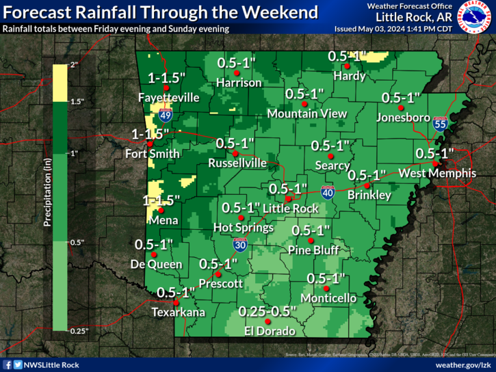
Rain will become plentiful across much of the state over the next week or so, with rainfall amounts over 4 inches possible across western and portions of central sections of Arkansas. Most of the rain will fall on Friday and Sunday into Monday.
On this day in Arkansas Weather History, 90 years ago, impacts from the Dust Bowl were felt across the state. Specifically, in Little Rock, the Weather Bureau noted reduced visibility from the blowing dust to as low as three miles lasting throughout the day.
 
Hourly Weather Roundup ( )
Location Sky/Weather Temp Dewpt RH Wind Baro Remarks
Fayetteville
N/A
N/A
N/A
N/A
N/A
N/A
N/A
Harrison
N/A
N/A
N/A
N/A
N/A
N/A
N/A
Mountain Home
N/A
N/A
N/A
N/A
N/A
N/A
N/A
Jonesboro
N/A
N/A
N/A
N/A
N/A
N/A
N/A
Fort Smith
N/A
N/A
N/A
N/A
N/A
N/A
N/A
Russellville
N/A
N/A
N/A
N/A
N/A
N/A
N/A
Mount Ida
N/A
N/A
N/A
N/A
N/A
N/A
N/A
Hot Springs
N/A
N/A
N/A
N/A
N/A
N/A
N/A
Little Rock
N/A
N/A
N/A
N/A
N/A
N/A
N/A
North Little Rock
N/A
N/A
N/A
N/A
N/A
N/A
N/A
West Memphis
N/A
N/A
N/A
N/A
N/A
N/A
N/A
Texarkana
N/A
N/A
N/A
N/A
N/A
N/A
N/A
El Dorado
N/A
N/A
N/A
N/A
N/A
N/A
N/A
Pine Bluff
N/A
N/A
N/A
N/A
N/A
N/A
N/A
Monticello
N/A
N/A
N/A
N/A
N/A
N/A
N/A
Note: "N/A" or "MISG" will be displayed if values are not available. In the LOCATION column, click on links for a list of recent observations at sites of interest. In the WIND column, VRB is "variable" and G is "gust". Wind speeds are in MPH. In the BARO (pressure) column, values are in inches. In the REMARKS column, HX is "heat index", WCI is "wind chill index", and VSB is "visibility" (if shown).
 
 
Point Forecasts
Cities in Arkansas Coordinates (make sure "Lon" is negative)
Lat:   Lon:
 
Local Hazards
Local Hazards
Decision Support
Decision Support
Submit Storm Report
Submit Storm Report
Local Forecast Page
Local Forecast Page
Radar Links
Radar Links
Local Climate Page
Local Climate Page
Local Observations Page
Local Satellite Page
Local Drought Page
Local Drought Page
Local Hydrology Page
Local Fire Page
Local Fire Page
Text Product Viewer
Text Product Viewer