National Weather Service United States Department of Commerce
Click a location below for detailed forecast.

Last Map Update: Thu, Apr. 18, 2024 at 5:19:55 pm CDT

National Weather Service Tulsa, OKNational Weather Service Springfield, MONational Weather Service Paducah, KY
National Weather Service Norman, OKZoom
Out

National Weather Service Memphis, TN
National Weather Service Fort Worth/Dallas, TXNational Weather Service Shreveport, LANational Weather Service Jackson, Mississippi

Here is a regional radar view.
Thursday into Thursday night will present the opportunity for severe weather across Arkansas. The main threats will be damaging winds and large hail. A non-zero tornado risk does exist, but the primary threats remain large hail and damaging winds.
Severe weather threats for Thursday afternoon into Thursday evening remain focused on large hail and damaging winds as the primary threats, especially across northwest Arkansas which could see 2+ inch diameter hail. A non-zero, but very low tornado risk does exist for a large portion of the state.
Friday morning temperatures will be varying across the state as a cold front will be moving through the state Thursday night ushering in cooler air behind the state. Expect mid 40s across northwest Arkansas, to mid 50s across central Arkansas, to lower 60s across southern and southeastern Arkansas.
Friday afternoon high temperatures will range from the mid 60s to low 70s.
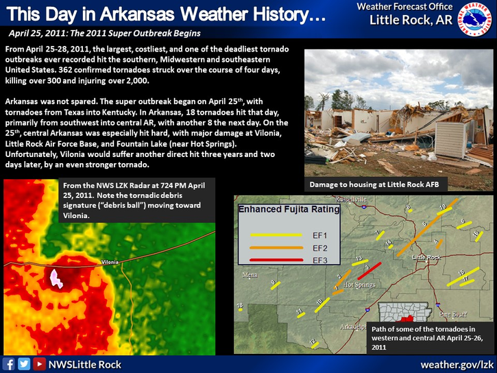
On this day in 1880, a tornado outbreak hit the mid western US, extending into the Mid-South. Seven tornadoes touched down across central and northwestern parts of the state. There were seven fatalities in Arkansas, with most being south of Fort Smith.
 
Hourly Weather Roundup ( )
Location Sky/Weather Temp Dewpt RH Wind Baro Remarks
Fayetteville
N/A
N/A
N/A
N/A
N/A
N/A
N/A
Harrison
N/A
N/A
N/A
N/A
N/A
N/A
N/A
Mountain Home
N/A
N/A
N/A
N/A
N/A
N/A
N/A
Jonesboro
N/A
N/A
N/A
N/A
N/A
N/A
N/A
Fort Smith
N/A
N/A
N/A
N/A
N/A
N/A
N/A
Russellville
N/A
N/A
N/A
N/A
N/A
N/A
N/A
Mount Ida
N/A
N/A
N/A
N/A
N/A
N/A
N/A
Hot Springs
N/A
N/A
N/A
N/A
N/A
N/A
N/A
Little Rock
N/A
N/A
N/A
N/A
N/A
N/A
N/A
North Little Rock
N/A
N/A
N/A
N/A
N/A
N/A
N/A
West Memphis
N/A
N/A
N/A
N/A
N/A
N/A
N/A
Texarkana
N/A
N/A
N/A
N/A
N/A
N/A
N/A
El Dorado
N/A
N/A
N/A
N/A
N/A
N/A
N/A
Pine Bluff
N/A
N/A
N/A
N/A
N/A
N/A
N/A
Monticello
N/A
N/A
N/A
N/A
N/A
N/A
N/A
Note: "N/A" or "MISG" will be displayed if values are not available. In the LOCATION column, click on links for a list of recent observations at sites of interest. In the WIND column, VRB is "variable" and G is "gust". Wind speeds are in MPH. In the BARO (pressure) column, values are in inches. In the REMARKS column, HX is "heat index", WCI is "wind chill index", and VSB is "visibility" (if shown).
 
 
Point Forecasts
Cities in Arkansas Coordinates (make sure "Lon" is negative)
Lat:   Lon:
 
Local Hazards
Local Hazards
Decision Support
Decision Support
Submit Storm Report
Submit Storm Report
Local Forecast Page
Local Forecast Page
Radar Links
Radar Links
Local Climate Page
Local Climate Page
Local Observations Page
Local Satellite Page
Local Drought Page
Local Drought Page
Local Hydrology Page
Local Fire Page
Local Fire Page
Text Product Viewer
Text Product Viewer