 |
| For Your Information |
| If there is something that may be of interest to you, we will try to make that information available. |
|
|
 |
Launching Balloons |
 |
| |
 |
Early in the morning and toward evening (twice a day), the local National Weather Service (NWS) office is one of over 100 sites in North America, the Pacific islands and the Caribbean that launches a weather balloon. Forecasting future conditions depends heavily on what is going on aloft. Balloons are used to gather data to make forecasting easier. |
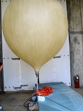
| In the picture: A balloon is about ready for launch inside the inflation shelter at NWS Little Rock (Pulaski County). |
| Each flight, a radiosonde and parachute are attached to the balloon with 120 feet of string. As the balloon goes up, decreasing pressure causes it to expand and eventually break. By the time that happens, the balloon is often at an altitude of 100,000 feet or more! |
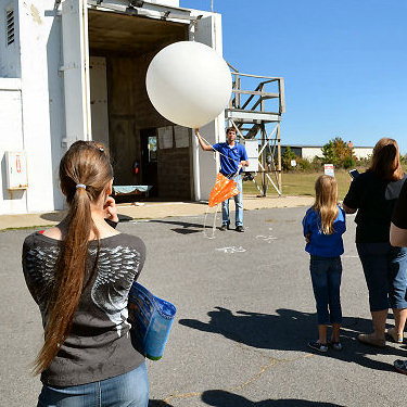 |
| In the picture: This balloon was launched during a tour of NWS Little Rock (Pulaski County) at an open house in October, 2012. |
|
Once the balloon explodes, the radiosonde is carried back to the ground by the parachute. On summer days, winds aloft are usually weak, and the radiosonde may land within a few miles of the office. When the weather becomes more changeable (such as during the fall and spring), winds overhead pick up, and the radiosonde may end up more than 100 miles away.
|
 |
The radiosonde is the most valuable component of the flight. It transmits temperature and relative humidity data at each pressure level (i.e. 850 millibars or 5000 feet, 700 millibars or 10000 feet, 500 millibars or 18000 feet, etc). Wind speed and direction are calculated based on the position of the device with time.
|
| In the picture: A radiosonde (attached to a weather balloon) is shown during a tour of NWS Little Rock (Pulaski County) at an open house held in October, 2012. |
|
All of this information is sent to a receiver at the office. Using the data, forecasters have a better handle of where storms systems and fronts are at the time of the flight, the strength of these features and moisture available to make precipitation. The features can be tracked through time as data is processed and plugged into weather prediction models.
There are times when special releases are necessary. Quite often, when significant tropical systems are threatening to make landfall somewhere in the country, select offices will be asked to launch balloons every 6 hours or so. Special flights are also performed when severe weather outbreaks (including tornadoes) are expected.
By the way, if you happen to find a radiosonde after it has landed, the NWS would appreciate you returning it. There is a notice on the side of the radiosonde that informs you of the mail pouch inside the device, and the postage is prepaid. Unfortunately, the NWS recovers less than 20 percent of the radiosondes released each year.
|
|
|


 Follow us on YouTube