 |
| About This Page |
| Arkansas has had its share of historic events, many of which will be in our memories for years to come. |
|
|
 |
Tornadoes/Flooding on April 27-28, 2014 |
 |
| |
| One to Remember |
| |
| 2014 was considered slow for severe weather. There were only 20 tornadoes in Arkansas, and a minuscule 7 tornadoes in the spring (March, April and May). One of these was a monster that claimed more lives than any other tornado nationwide during the year. This horror show lasted 56 minutes (706 pm to 802 pm CST) and wiped away years of memories. It is something that will never be forgotten. |
| What Happened |
| |
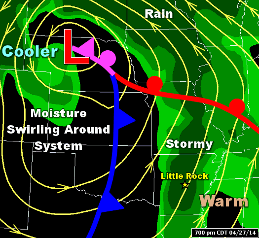 |
| In the picture: It became stormy in Arkansas ahead of a storm system ("L") and cold front on 04/27/2014. |
|
| |
|
A powerful storm system entered the Plains from the Rockies early on April 27th. The system dragged a cold front toward the region, and thunderstorms became likely.
|
|
|
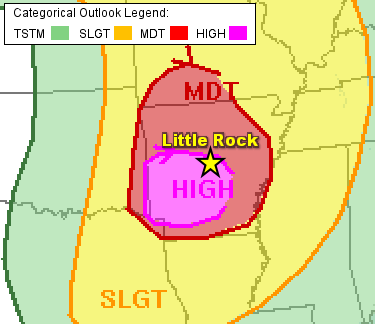
This event looked ominous, and was expected to become the largest severe weather episode of the spring. Strong tornadoes (at least EF2) and very large hail (bigger than golf balls) were anticipated.
|
| In the picture: The Day 1 categorical outlook for 04/27/2014 called for a moderate to high risk of severe weather over much of Arkansas. The forecast was courtesy of the Storm Prediction Center. |
| The Human Element |
|
This website has numerous event pages filled with explanations, facts and figures. This is one of those pages, but there is a very important aspect that must be covered. Any event like this is about the people. It is about personal experiences, miracles and tragedies. There are stories out there that catch your attention. As one television meteorologist put it on Twitter after finding a story: "You should read this blog. This is reality. This is not numbers and radar images. This is what happened." Absolutely right.
Around Mayflower (Faulkner County), there was a story about a family with a basement on Lake Conway, and they shared their space with a lot of local residents. While the house took a direct hit from the tornado, they all made it. Then there was the story about the Air Force airman in Vilonia (Faulkner County) who shielded his daughter from the monster we all know about now. His mission was successful, but he lost his life. Today, his daughter calls her daddy a hero. Not far away, a college student knew it was going to be bad, and he was scared. But even in a time of crisis, he thought to send a text: "Goodbye, mama." Those were his last words, but what a gift to his mother. Another local resident got a call from his father, and was told a tornado was coming. The man took his sons to an interior room, but thought it might not be enough protection. They ran to their truck and headed to a community safe room. It was a wise decision. When they returned, the house was gone. And then there was the woman in the same area that tried frantically to reach her friend following the storm. No luck. She sent her husband to find out what happened. When she texted him, there was no answer at first. According to her blog, her texts became frantic: "Are they hurt? Are they alive? Miah (her husband), please tell me they are alive." His response: "I can't." Her friend survived (with extensive injuries), but her two boys did not.
The stories of people living the events greatly affect those covering the events. Even here at the National Weather Service, there is a feeling of helplessness when a tornado is tearing up the countryside. The mission of protecting life and property is the focus, and we hope people are getting the warnings and finding shelter. But when the reports roll in, and the words are filled with suffering, that's hard to deal with at times. As one of our local forecasters wrote, "I'll never be the same again. I’ve worked many severe weather days - and a few tornadoes. But this one was different. The only thing I can think of is that I have more years as a husband and father under my belt. You really have an understanding of how precious and fragile life is and can be. And you try to take it less for granted."
This is the human element. It is emotions, feelings, and coping. It is not a bunch of statistics. Now you have the whole story.
|
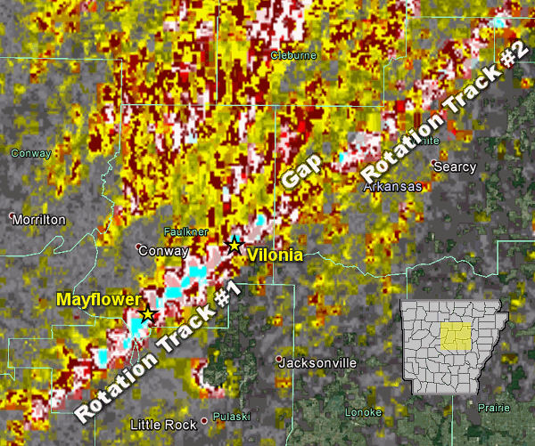 |
| In the picture: Rotation associated with the parent storm on 04/27/2014 was persistent for roughly 40 miles (Rotation Track #1) before weakening (where the gap is indicated). Other smaller tornadoes (Rotation Track #2) were spawned by the same storm and tracked through White, Jackson, and Independence Counties. The graphic is courtesy of the National Severe Storms Laboratory. |
|
| |
|
While this did not turn into an outbreak of severe weather, the ferocity of at least one storm was realized. Just after 700 pm CDT, a supercell (storm with rotating updrafts) rapidly intensified northwest of the Little Rock (Pulaski County) area.
|
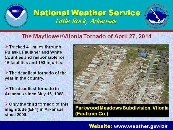
| A destructive tornado was produced, and tracked 41 miles through Mayflower and Vilonia (both in Faulkner County) before dissipating near El Paso (White County). Tornado Emergencies were issued for these towns by the National Weather Service. The tornado was given a rating of EF4 (166-200 mph winds). |
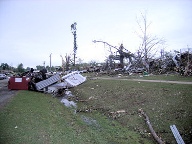 |
| In the picture: Everything was torn up by tornado (rated EF4) along Highway 365 in Mayflower (Faulkner County) on 04/27/2014. Click to enlarge. |
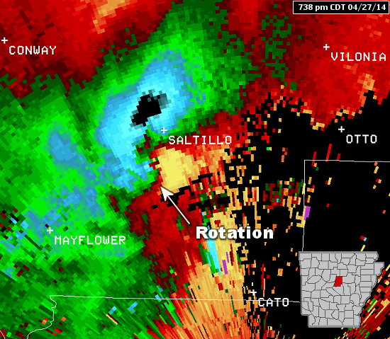 |
| Rotation | Debris Ball | Radar Loop | More About Rotation |
| In the pictures: The WSR-88D (Doppler Weather Radar) showed strong rotation between Mayflower and Vilonia (both in Faulkner County) at 738 pm CDT on 04/27/2014. There was also a debris ball present, which is a very good indicator of a tornado causing damage. |
|
| |
|
Along the way, houses and businesses were heavily damaged or reduced to rubble. An estimated 400 to 500 homes were destroyed. There were 16 fatalities reported (12 in Faulkner County, 3 in Pulaski County and 1 in White County), which makes this the deadliest single tornado in Arkansas since the Jonesboro (Craighead County) twister (rated EF4) of May 15, 1968 (35 fatalities).
|
| Some Tornado Facts |
| 1. |
The last time Vilonia (Faulkner County) was devastated by a tornado was April 25, 2011. On that day, a long-track (just over 51 miles) EF2 tornado killed four people on the southwest side of town. |
| 2. |
Since reliable records began in 1950, Vilonia (Faulkner County) has had five tornadoes track through present day city limits. Aside from the April 27, 2014 and April 25, 2011 events, the other episodes happened on December 24, 1982 (rated F3), December 23, 1982 (rated F2) and March 12, 1961 (rated F2). |
| 3. |
There had not been a tornado this strong (at least EF4) locally since May 25th in 2011 (a 1,068 day lag). This tornado tracked 46 miles through Franklin, Logan and Johnson Counties. After that, no other tornado was rated higher than EF3. |
| 4. |
This was the first EF4 or stronger tornado in the United States in 2014, and only the third such tornado in Arkansas since 2000. |
| 5. |
This tornado was more deadly than other fairly recent historic events. This includes the Interstate 30 twister (rated F4) of March 1, 1997 that caused 15 fatalities in Saline and Pulaski Counties. Also, there was the Super Tuesday (February 5th), 2008 tornado (rated EF4) that cut a 122 mile swath through seven counties across the north and killed 13 people. |
| 6. |
Since 2000 (including this event), there were 610 tornadoes and 68 tornado related fatalities in the state. Only 4 percent of the tornadoes (27 of them) were F3/EF3 or stronger, but they caused 79 percent of the tornado related fatalities (54 of them). |
|
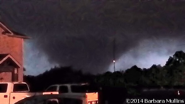 |
| In the picture: A wedge tornado was witnessed at Vilonia (Faulkner County) during the evening of 04/27/2014. The photo is courtesy of Barbara Mullins via Twitter. |
|
| |
|
Farther northeast, the parent storm dropped four more tornadoes (rated EF0 to EF2) as it headed toward Center Hill (White County), Steprock (White County), Denmark (White/Jackson County line) and Thida (Independence County).
|
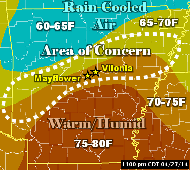 |
What determined where the parent storm would ignite? Quite often, there is a boundary in play. In this case, clouds and thunderstorms earlier in the day kept areas to the north cool, with much warmer conditions and more humidity to the south. The dividing line between these air masses is where the parent storm focused. |
| In the picture: The pattern at 1100 pm CDT on 04/27/2014. Temperatures were only in the 60s across the Ozark Mountains (of northern Arkansas), and well into the 70s with higher moisture levels in the south. The environment was the most unstable between these very different air masses (the area of concern), and this is where the tornadic storm flourished. |
|
Interestingly, the terrain can play an important role in determining where these boundaries set up. Cool air in the hills (the Ozark and Ouachita Mountains of the north/west) is hard to displace at times (it gets trapped), so the boundaries are frequently aligned along the eastern edge of the terrain, or close to the Interstate 30 and U.S. 67/167 corridors. This is considered "tornado alley" locally.
Before the tornadoes, a few storms unloaded very large hail in the northern half of the state. Tennis ball size hail hit Henderson (Baxter County), with ping pong to golf ball size hail at Dover (Pope County), near Waldron (Scott County) and south of Marshall (Searcy County). This happened between 400 pm and 700 pm CDT.
|
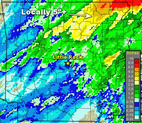 |
| In the picture: Twenty four hour rainfall through 700 am CDT on 04/28/2014. |
|
| |
|
The other significant part of this story was the rain. There was a lot of it in northeast Arkansas. Locally more than five inches of water was measured in the twenty four hour period ending at 700 am CDT on the 28th. This included a whopping 7.60 inches at Batesville Lock and Dam (Independence County) and Beedeville (Jackson County), 6.10 inches at Calamine (Sharp County), 6.03 inches at Corning (Clay County), 5.34 inches at Evening Shade (Sharp County), 5.30 inches at Ravenden Springs (Randolph County), 5.20 inches at Pocahontas (Randolph County) and 5.05 inches at Melbourne (Izard County).
The 7.60 inches at Batesville Lock and Dam (Independence County) was the most for one day since records were established in 1904. This helped pushed the monthly total to 12.33 inches, making it the third wettest April locally.
This much rain caused extensive flash flooding, with numerous roads under water. There was a mudslide on Highway 25 southwest of Desha (Independence County). A bridge was submerged (likely by a creek) along Highway 25 between Batesville and Moorefield (Independence County). Highway 69 was flooded at Mount Pleasant (Izard County). The price tag on road and bridge repair (due to water) was an estimated $1.5 million in Lawrence and Sharp Counties.
|
| Federal Disaster Declaration |
|
Twelve (12) counties were declared federal disaster areas following this event. Infrastructure damage and debris removal was estimated around $14 million in these counties, and does not include destruction to private property. Counties declared for mainly high water/flooding included Clay, Cleburne, Fulton, Independence, Izard, Lawrence, Randolph and Sharp. These counties are in northeast Arkansas. Toward central sections of the state, Faulkner, Pulaski and White Counties were declared for tornado related costs. Jackson County was declared for tornado/flood damage.
|
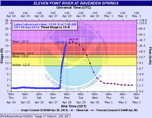 |
| In the picture: The hydrograph for the Eleven Point River at Ravenden Springs (Randolph County) projected moderate to major flooding by the afternoon of 04/28/2014. |
|
| |
|
Small rivers and streams were on the rise in the northeast, with moderate to major flooding along the Spring River at Hardy (Sharp County) and Imboden (Lawrence County), and the Eleven Point River at Ravenden Springs (Randolph County). In the days to follow, flooding was generally minor along the Black and lower White Rivers.
|
| There were reports of tornadoes, large hail, damaging winds and flooding on April 27th and 28th (early), 2014. For a look at some reports, click here.
|
|
| In the picture: Preliminary reports of severe weather and flooding in the Little Rock County Warning Area on April 27-28, 2014 (in red). |
|


 Follow us on YouTube