 |
| About This Page |
| Arkansas has had its share of historic events, many of which will be in our memories for years to come. |
|
|
 |
Severe Weather on June 12, 2009 |
 |
| |
|
|
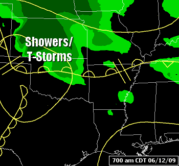
A front in southern Missouri wobbled into northern Arkansas on the 12th before becoming nearly stationary. |
| In the pictures: Showers and thunderstorms tracked along a nearly stationary front into Arkansas on 06/12/2009. |
| An MCS (Mesoscale Convective System...or large cluster of thunderstorms) developed in Kansas and Oklahoma early in the day. The MCS followed the front into Arkansas by the afternoon. |
|
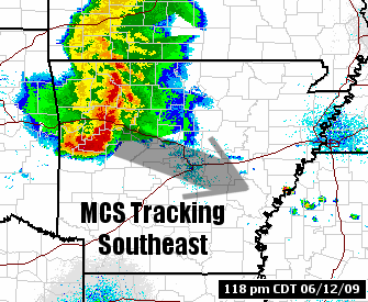
| In the picture: The WSR-88D (Doppler Weather Radar) showed an MCS (Mesoscale Convective System...or a large cluster of thunderstorms) surging from western into central Arkansas at 118 pm CDT on 06/12/2009. |
 |
The leading edge of the MCS, a bow echo, produced 60 to 80 mph winds...with locally higher gusts (more than hurricane force) as it raced from northwest into central and east central sections of the state.
|
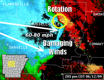
| In the picture: The WSR-88D (Doppler Weather Radar) showed 60 to 80 mph inbound (toward the radar) winds surging toward central Arkansas at 205 pm CDT on 06/12/2009. The winds were associated with a fast moving bow echo. On the north end of the bow, there were several instances of rotation...and Tornado Warnings issued. |
| The bow echo entered the state around 12 pm CDT and reached the Mississippi River around 430 pm CDT. |
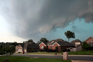 |
| In the picture: Severe thunderstorms rolled into the Little Rock (Pulaski County) area between 230 pm and 300 pm CDT on 06/12/2009. Click to enlarge. |
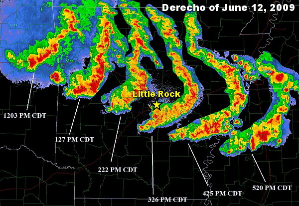 |
| In the picture: A long-lived bow echo, or "derecho" (Spanish for "straight", or in this case, straight-line winds), rocketed eastward across Arkansas in four to five hours during the afternoon of 06/12/2009. |
|
| |
|
A bow echo is a backwards "C" shaped line of storms. Strong to damaging winds often punch through the rear of the storms, causing them to bulge forward (which explains the bowing).
|
|
|
There were numerous trees and powerlines downed, and spotty structural damage. At least 70,000 homes were left without power. |
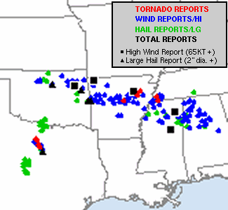
| In the picture: Severe weather reports on 06/12/2009. The graphic is courtesy of the Storm Prediction Center in Norman, OK. |
| There were also some tornado and funnel cloud reports. One tornado (rated EF1) was spawned from just south of St. Vincent to around Solgohachia (both in Conway County). |
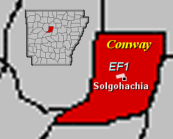 |
| In the picture: A weak (EF1) tornado was noted in Conway County on 06/12/2009. |
| The bow echo continued through Mississippi and Alabama before weakening during the evening. Because it traveled for several hundred miles, caused extensive wind damage and followed a boundary (stalled front)...it can be classified as a progressive derecho (Spanish for "straight", or in this case, straight-line winds). |
|
|
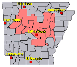
There was widespread wind damage and a tornado on the 12th. To check out the reports, click here. |
| In the picture: Preliminary reports of severe weather in the Little Rock County Warning Area on June 12, 2009 (in red). |
|
|


 Follow us on YouTube