National Weather Service United States Department of Commerce
Historic Weather Events
About This Page
Arkansas has had its share of historic events, many of which will be in our memories for years to come.
 
Tornado Outbreak (November 27, 2005)
 
Twenty four tornadoes were spawned on November 27, 2005. In most of 2005, there was not much severe weather. In fact, through the Summer, there were only four tornadoes statewide. The remnants of Hurricane Rita added eleven more tornadoes to the total in September... but it was nothing like the tornado outbreak that followed on November 27th.
In the picture: Twenty four tornadoes were spawned on November 27, 2005.


Link of Interest
More Detailed Track Map


On that day, severe storms tracked through mainly northern and central Arkansas during the afternoon and evening hours. The storms spawned two dozen tornadoes...mostly mostly between 3 pm and 9 pm CST. The WSR-88D (Doppler Weather Radar) showed areas of strong rotation with tornadoes produced on 11/27/2005.
In the picture: The WSR-88D (Doppler Weather Radar) showed areas of strong rotation with tornadoes produced on 11/27/2005. Tor #1tracked through Blackwell (Conway County), Tor #2 hit Cherry Hill (Perry County) and Plumerville (Conway County) and Tor #3 affected areas near Pearcy (Garland County).


The WSR-88D (Doppler Weather Radar) indicated a hook echo approaching Cherry Hill (Perry County) from the southwest around 550 pm CST on 11/27/2005. The strongest tornadoes occurred in Perry and Conway Counties. There were two F3 tornadoes (158-206 mph winds) spawned in this two county area, with 1 fatality reported. The fatality occurred near Plumerville (Conway County)...when one of the tornadoes crossed Interstate 40 and threw several vehicles.
In the picture: The WSR-88D (Doppler Weather Radar) indicated a hook echo approaching Cherry Hill (Perry County) from the southwest around 550 pm CST on 11/27/2005. To sample the storm, the radar sends energy...which is reflected back if there is precipitation. In this case, the radar detected a high level of reflectivity in the hook, which often means that debris is present.


Other Prominent Tornadoes
 

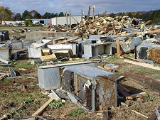
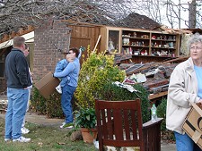
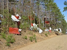
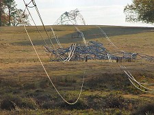
A tornado (rated F2) tracked through the Blackwell and Saint Vincent (both in Conway County) areas. A liquor store at Blackwell (Conway County) was destroyed, and several chicken houses were damaged.

Other tornadoes (rated F2) affected areas from Springfield (Conway County) to Bee Branch (Van Buren County), and from almost 10 miles southeast of Bee Branch (Van Buren County) to a few miles northwest of Pearson (Cleburne County). An auto repair shop (a two bay garage) was destroyed, with roofs removed from several homes. Numerous barns and outbuildings were damaged or destroyed.

Farther southwest, a tornado (rated F2) hit areas from near Bonnerdale (Hot Spring County) to around Mountain Pine (Garland County). A mobile home was destroyed (and a man was injured)just south of Pearcy (Garland County), with a brick home heavily damaged north of Hempwallace (Garland County) in the Sunshine community.


Damage Pictures
A strong (F2) tornado heavily damaged a liquor store in Blackwell (Conway County) on 11/27/2005.
In the picture: A strong (F2) tornado heavily damaged a liquor store in Blackwell (Conway County) on 11/27/2005. Click to enlarge.
A recreational vehicle and refrigeration shop was destroyed near the Sardis Community (about 2 miles southeast of Morrilton in Conway County) by a strong (F3) tornado on 11/27/2005.
In the picture: A recreational vehicle and refrigeration shop was destroyed near the Sardis Community (about 2 miles southeast of Morrilton in Conway County) by a strong (F3) tornado on 11/27/2005. Click to enlarge.
 
A brick home was ripped open by a strong (F2) tornado near Sunshine (Garland County) on 11/27/2005.
In the picture: A brick home was ripped open by a strong (F2) tornado near Sunshine (Garland County) on 11/27/2005. A tree also fell through the house. Click to enlarge.
Tin from a barn was strewn through the trees near Bee Branch (Van Buren County) following a strong (F2) tornado on 11/27/2005.
In the picture: Tin from a barn was strewn through the trees near Bee Branch (Van Buren County) following a strong (F2) tornado on 11/27/2005. Click to enlarge.
 
Transmission towers were mangled by a strong (F3) tornado near Cherry Hill (Perry County) on 11/27/2005.
In the picture: Transmission towers were mangled by a strong (F3) tornado near Cherry Hill (Perry County) on 11/27/2005. Click to enlarge.