
A few strong to marginally severe thunderstorms are possible across the Southeast U.S. Friday. A Marginal Risk (Level 1 of 5) outlook has been issued. Strong winds and hail will be the main threats. Elevated to locally critical fire weather conditions will persist across south-central Colorado today due to dry conditions and gusty winds. Read More >
On Sunday, April 12, the National Weather Service in Midland conducted a damage survey of a high wind event that occurred across the northern portions of the city of Odessa on the evening of Saturday, April 11.
The damage survey showed a damage path approximately 1.25 miles long and 25 yards wide, running from just west of the intersection of Skyline Drive and 83rd Street to the eastern extent of Edgeport Drive. Residents at several locations within the damage area witnessed a tornado-like feature in association with this damage.
Eyewitness descriptions combined with damage trajectories and radar imagery suggest that the tornado-like feature was likely outflow-related and will be classified as a gustnado. It is likely that this gustnado enhanced wind speeds in its path. Damage across the area was typical of events with wind speeds in the 80-90 mph range. While this event will not be categorized as as tornado with a formal intensity rating, damage that occurred was significant and similar to that of high end EF0 or lower end EF1 damage.
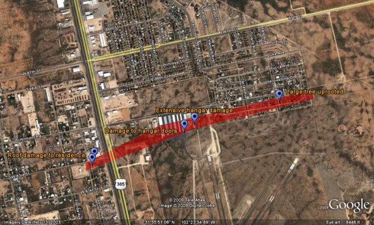
Click the image above to explore the damage further using Google Earth.

This residence sustained major damage. The design of the roof, with a portion if it having a pitch perpendicular to the damaging wind, resulted in a large portion of the roof lifting off the home. The roof was blown towards the east northeast. Portions of the roof came to rest across 83rd street, as well as across Andrews Highway adjacent to Schlemeyer Airport. Residents also confirmed the existence of a tornado-like feature approximately 25 yards wide. The image above is taken from the front bedroom.
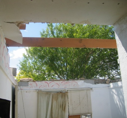
The image above is taken from the living room of the damaged residence.
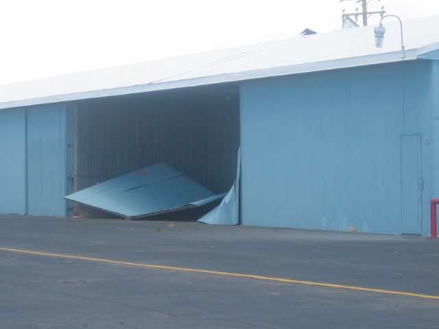
Extensive damage also occured to the hangars located at Eagle Aire. The following image is an example of hangar door damage that occurred to the majority of the hangars at this location.
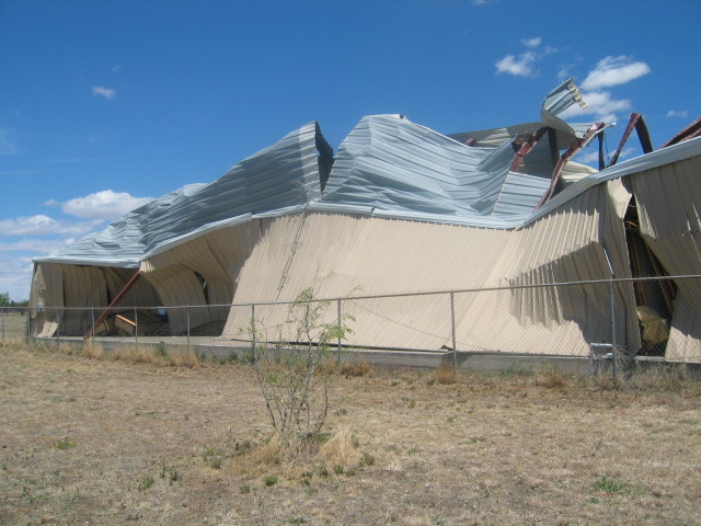
Strong west southwest winds resulted in the caving in of the entire west side of the hangar. In addition, a building on the inside of the hangar was moved approximately 12 feet as the west wall of the hangar was pushed inward. In addition, eyewitnesses reported a tornado-like feature between 20 and 30 yards wide approaching rapidly from the west southwest. See the image link below.
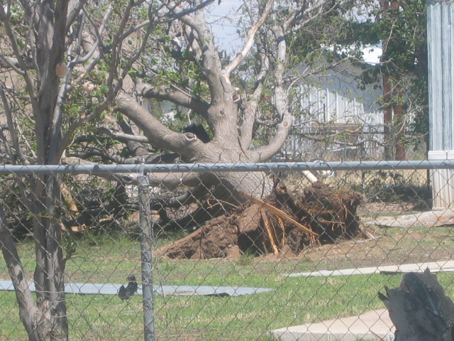
Several large trees were uprooted along Edgeport Road. This large and mature tree was uprooted due to the high winds.
On Monday, April 13, the National Weather Service in Midland also conducted a damage survey of eastern Midland County and western portions of Glasscock County to investigate potential damage from a supercell thunderstorm that occurred Saturday evening.
The damage survey team found a snapped power pole 1.5 miles east of the Midland and Glasscock county line. This pole was snapped approximately 8 feet above ground level. Another nearby power pole sustained slight damage near the top of the pole. An area of mesquite trees slightly farther to the east northeast also showed slight damage. These observations all suggest the presence of a brief tornado touchdown just to the south of Highway 158, with the tornado crossing the highway prior to lifting.
While areas of potential high winds were noted along Farm to Market Road in Midland County, there was not enough evidience to suggest that tornado formation had occurred in Midland County. Thus, the damage path for this tornado touchdown in Glasscock County will be estimated at approximately 3/4 mile. The tornado width will be estimated at 50 yards, which is consistent with the eye witness report received by the National Weather Service.
Based on visible damage, the tornado will be classified as a weak EF0 tornado.
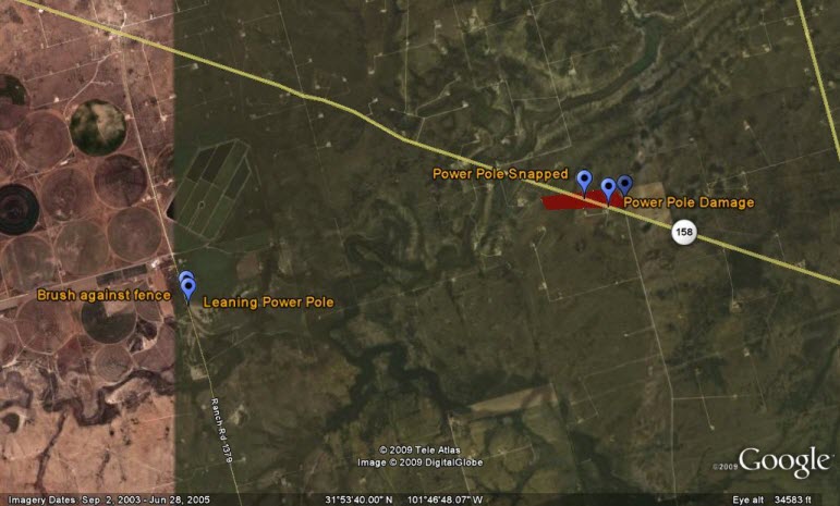
Click the image above to explore the damage further using Google Earth.
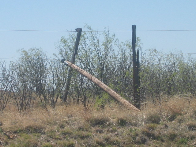
This power pole was snapped approximately 8 feet above the ground and represents the primary location where the tornado crossed Highway 158.
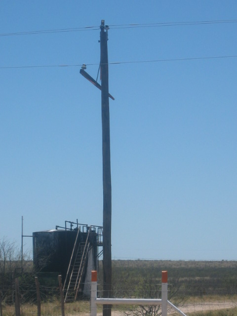
Power pole damage was noted along Highway 158. The image above shows slight wind damage to the upper portions of the pole.
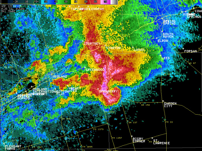
The image above shows a "hook" echo associated with the tornadic supercell.
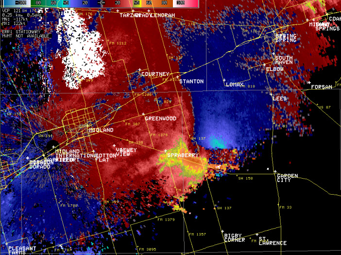
In the image above, the National Weather Service Doppler radar is located on the left side of the image near the point labeled "Midland International Airport". The light blue and cyan colors represent winds flowing toward the radar and the yellow and orange colors represent winds flowing away from the radar. Strong, cyclonic rotation is shown in this tornadic supercell.
PRELIMINARY LOCAL STORM REPORT...SUMMARY
NATIONAL WEATHER SERVICE MIDLAND/ODESSA TX
1243 PM CDT SUN APR 12 2009

..TIME...   ...EVENT...      ...CITY LOCATION...     ...LAT.LON...
..DATE...   ....MAG....      ..COUNTY LOCATION..ST.. ...SOURCE....
            ..REMARKS..

0356 PM     HAIL             HOBBS                   32.73N 103.16W
04/11/2009  E1.00 INCH       LEA                NM   TRAINED SPOTTER

0358 PM     HAIL             HOBBS                   32.73N 103.16W
04/11/2009  E1.75 INCH       LEA                NM   LAW ENFORCEMENT

0400 PM     FUNNEL CLOUD     LOVINGTON               32.95N 103.35W
04/11/2009                   LEA                NM   LAW ENFORCEMENT

            UNKNOWN IF IT TOUCHED GROUND

0400 PM     HAIL             LOVINGTON               32.95N 103.35W
04/11/2009  E1.00 INCH       LEA                NM   LAW ENFORCEMENT

0400 PM     HAIL             2 S LOVINGTON           32.92N 103.35W
04/11/2009  E1.75 INCH       LEA                NM   LAW ENFORCEMENT

0430 PM     HAIL             7 SE HOBBS              32.66N 103.08W
04/11/2009  E1.00 INCH       LEA                NM   TRAINED SPOTTER

            NICKEL TO QUARTER SIZE HAIL REPORTED.

0431 PM     HAIL             HIGGINBOTHAM            32.90N 102.99W
04/11/2009  E1.75 INCH       GAINES             TX   TRAINED SPOTTER

0450 PM     HAIL             HIGGINBOTHAM            32.90N 102.99W
04/11/2009  E1.75 INCH       GAINES             TX   PUBLIC

0517 PM     HAIL             PECOS                   31.41N 103.50W
04/11/2009  E0.88 INCH       REEVES             TX   PUBLIC

0522 PM     HAIL             HOBBS                   32.73N 103.16W
04/11/2009  E0.75 INCH       LEA                NM   AMATEUR RADIO

0522 PM     TSTM WND GST     HOBBS                   32.73N 103.16W
04/11/2009  E75.00 MPH       LEA                NM   AMATEUR RADIO

            ESTIMATED WIND GUST OF 60 TO 75 MPH.

0530 PM     HAIL             EUNICE                  32.44N 103.19W
04/11/2009  E1.75 INCH       LEA                NM   LAW ENFORCEMENT

            EUNICE PD - SMALL TO GOLF BALL HAIL

0538 PM     HAIL             S KERMIT                31.85N 103.09W
04/11/2009  E0.88 INCH       WINKLER            TX   TRAINED SPOTTER

0538 PM     HAIL             HIGGINBOTHAM            32.90N 102.99W
04/11/2009  E0.75 INCH       GAINES             TX   TRAINED SPOTTER

0540 PM     HAIL             S KERMIT                31.85N 103.09W
04/11/2009  E1.00 INCH       WINKLER            TX   TRAINED SPOTTER

0618 PM     HAIL             26 WNW ODESSA           32.00N 102.78W
04/11/2009  E1.00 INCH       ECTOR              TX   PUBLIC

0628 PM     HAIL             SEMINOLE                32.72N 102.65W
04/11/2009  E1.00 INCH       GAINES             TX   PUBLIC

0647 PM     HAIL             ODESSA                  31.85N 102.37W
04/11/2009  E1.00 INCH       ECTOR              TX   PUBLIC

0648 PM     HAIL             5 E GOLDSMITH           31.98N 102.53W
04/11/2009  E1.00 INCH       ECTOR              TX   TRAINED SPOTTER

0650 PM     HAIL             ODESSA                  31.85N 102.37W
04/11/2009  E1.00 INCH       ECTOR              TX   PUBLIC

0650 PM     TSTM WND DMG     ODESSA                  31.85N 102.37W
04/11/2009                   ECTOR              TX   BROADCAST MEDIA

            ROOFS RIPPED OF BUILDINGS AND DAMAGE TO TREES AND CARS IN
            NORTH ODESSA.

0653 PM     HAIL             ODESSA                  31.85N 102.37W
04/11/2009  E0.88 INCH       ECTOR              TX   PUBLIC

0653 PM     HAIL             5 ENE ODESSA            31.88N 102.29W
04/11/2009  E1.75 INCH       MIDLAND            TX   TRAINED SPOTTER

            GOLF BALL SIZED HAIL AT 191 AND FAUDREE DR.

0657 PM     TSTM WND GST     6 W LAMESA              32.73N 102.06W
04/11/2009  E70.00 MPH       DAWSON             TX   TRAINED SPOTTER

            ESTIMATED WIND GUST OF 60 TO 70 MPH ALONG HIGHWAY 62/180
            SIX MILES WEST OF LAMESA.

0700 PM     HAIL             MIDLAND INTERNATIONAL A 31.94N 102.19W
04/11/2009  E2.50 INCH       MIDLAND            TX   NWS EMPLOYEE

            TWO AND A HALF INCH HAIL REPORTED AT THE MIDLAND NATIONAL
            WEATHER SERVICE OFFICE.

0702 PM     HAIL             3 SW WARFIELD           31.89N 102.26W
04/11/2009  E1.25 INCH       MIDLAND            TX   TRAINED SPOTTER

0710 PM     HAIL             MIDLAND                 32.00N 102.08W
04/11/2009  E2.00 INCH       MIDLAND            TX   LAW ENFORCEMENT

            TWO INCH HAIL REPORTED AT LOOP 250 AND WADLEY DRIVE IN
            MIDLAND.

0712 PM     HAIL             MIDLAND                 32.00N 102.08W
04/11/2009  E2.00 INCH       MIDLAND            TX   PUBLIC

            TWO INCH HAIL REPORTED AT ILLINOIS AND MIDLAND DR IN
            MIDLAND. TWO INCH HAIL REPORTED AT LOOP 250 AND ANDREWS
            HIGHWAY.

0730 PM     HAIL             LAMESA                  32.73N 101.96W
04/11/2009  E1.00 INCH       DAWSON             TX   LAW ENFORCEMENT

0756 PM     TORNADO          6 SE SPRABERRY          31.87N 101.76W
04/11/2009                   GLASSCOCK          TX   TRAINED SPOTTER

            APPROX 5 TO 8 MILES SE OF INTERSECTION OF 1379 AND 158

0804 PM     TSTM WND GST     MIDLAND                 32.00N 102.08W
04/11/2009  M64.00 MPH       MIDLAND            TX   AWOS

0811 PM     HAIL             16 SE MIDLAND           31.84N 101.89W
04/11/2009  E1.50 INCH       MIDLAND            TX   PUBLIC

            GOLF BALL TO PING PONG SIZE HAIL REPORTED.

0815 PM     HAIL             17 W MIDKIFF            31.63N 102.13W
04/11/2009  E0.88 INCH       UPTON              TX   PUBLIC

0834 PM     HAIL             11 S BIG SPRING         32.09N 101.48W
04/11/2009  E1.00 INCH       GLASSCOCK          TX   TRAINED SPOTTER

            DIME TO QUARTER SIZE HAIL REPORTED 11 MILES SOUTH OF BIG
            SPRING.

0930 PM     HAIL             GARDEN CITY             31.87N 101.48W
04/11/2009  E1.00 INCH       GLASSCOCK          TX   LAW ENFORCEMENT

0931 PM     HAIL             BIG SPRING              32.25N 101.48W
04/11/2009  E0.88 INCH       HOWARD             TX   TRAINED SPOTTER

            PEA TO NICKEL SIZE HAIL AT THE AIRPORT IN BIG SPRING.

1145 PM     HAIL             33 NNE DRYDEN           30.49N 101.91W
04/11/2009  E0.88 INCH       TERRELL            TX   PUBLIC

            DIME TO NICKEL HAIL

0856 PM     FLASH FLOOD      MIDLAND                 32.00N 102.08W
04/11/2009                   MIDLAND            TX   AMATEUR RADIO

            3 TO 6 INCHES OF WATER AT INTERSECTION OF I-20 AND TX 158
            AND SIGNIFICANT FLOODING IN OTHER AREAS.

0820 PM     FLASH FLOOD      MIDLAND                 32.00N 102.08W
04/11/2009                   MIDLAND            TX   LAW ENFORCEMENT

            FLOODING AT 10TH ST AND FM 1936, DUNN ST

0805 PM     FLASH FLOOD      MIDLAND                 32.00N 102.08W
04/11/2009                   MIDLAND            TX   TRAINED SPOTTER

            FLOODING ACROSS FAIRGROUNDS

0825 PM     FLASH FLOOD      SEMINOLE                32.72N 102.65W
04/11/2009                   GAINES             TX   LAW ENFORCEMENT

            FLOODING IN SEMINOLE NEAR PIZZA HUT

0645 PM     HAIL             ODESSA                  31.85N 102.37W
04/11/2009  E1.00 INCH       ECTOR              TX   TRAINED SPOTTER

            QUARTER HAIL AT INTERSECTION OF ANDREWS AND 42ND.

