Showers and thunderstorms capable of producing widespread heavy rainfall will be possible across much of Puerto Rico today. Heavy rainfall will likely lead to flash, urban and small stream flooding. Some areas may face life-threatening flooding. In the Southeast U.S., strong to marginally severe thunderstorms will be possible this afternoon. Read More >
On Monday, March 19, 2012, the National Weather Service in Midland conducted a damage survey near the community of Gardendale, located over northern portions of Ector County.
Damage was a result of severe thunderstorms that occurred late Sunday night into early Monday morning. The following is a summary of findings from the NWS Midland damage survey team.
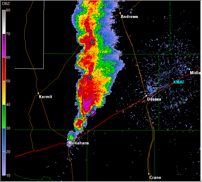
On Sunday night at 11:27 pm CDT, the National Weather Service in Midland issued a severe thunderstorm warning effective until Monday morning at 12:30 am CDT. The warning included much of Ector County including the Gardendale area. The following radar image shows severe thunderstorms moving to Ector County.
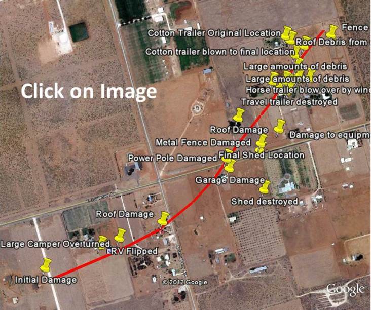
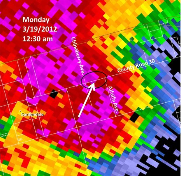
Based on interviews from residents in the Gardendale area, this warning provided as much as 63 minutes lead time for the event. The following is a closeup image of the radar at 12:30 am Monday morning. The damage area is also highlighted in the image. Damage occurred along County Road 30 (Goldenrod Drive), primarily between Chinaberry Ave. and Alfalfa Ave.
After viewing and plotting the damage, the NWS Midland damage survey team found sufficent reason to believe that the damage that occurred in the Gardendale area was the result of a short-lived, tornado. Radar imagery did detect a minor circulation with the supercell thunderstorm that moved across Ector County and the Gardendale area. However, radar data did not support the upgrade of the severe thunderstorm warning already in effect to a tornado warning for the affected area.
The tornado path was extremely narrow - perhaps 30-50 yards wide at its widest - and the tornado track was approximately one mile long. Based on the rapid movement of the thunderstorms, it is estimated that the tornado lasted approximately 2 minutes - from 12:28 am to 12:30 am. Debris trajectories were consistent throughout the damage path with that of a narrow, but relatively intense tornado. The event also presented a good example of how inflow winds outside of the actual tornado can reach severe levels. Due to the rapid movement of the thunderstorms, debris fields at times presented the look similar to a straight line wind event. Radar supported this observation, as velocities moving towards the radar were much stronger than those moving back towards the west. However, the damage survey team felt there was sufficient evidence between the brief circulation noted on radar and the information gathered from the primary area of damage north of County Road 30 and west of Alfalfa Ave. to call this event a tornado event.
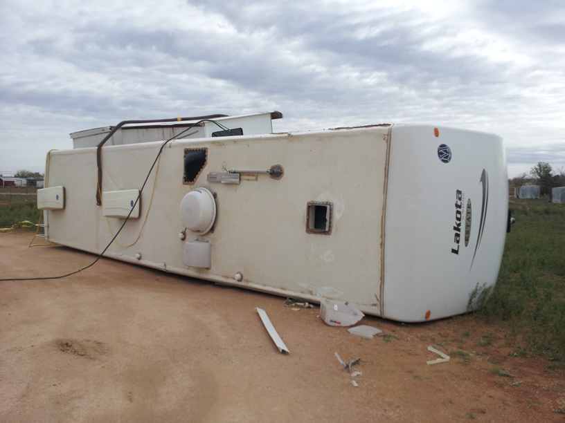
As the tornado developed, it moved just south of an RV Park located near the intersection of County Road 30 China Berry Ave. This resulted in a large camper being toppled by severe northwest winds flowing into the tornado. One minor injury was noted at this location.
As the tornado intensified and progressed northeastward, strong inflow winds from the south resulted in a cinder block fence being blown over to the north.
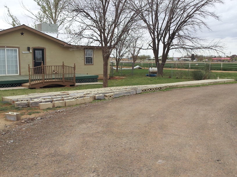
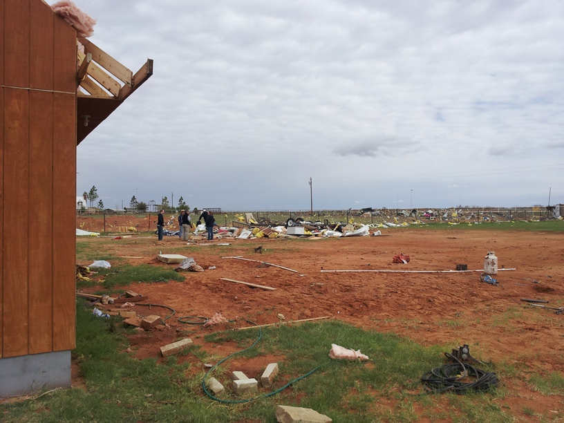
Finally, as the tornado crossed County Road 30 (Goldenrod Drive), it reached its peak intensity. This resulted in significant damage to a residential home, along with a 20' x 30' travel trailer and a barn being destroyed. Widespread damage was noted in this area, which also served as a collection point for a great amount of debris from other locations upwind back to the southwest.
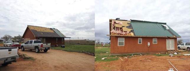
South of County Road 30, power poles with broken cross members were noted. This is indicative of EF1 tornado damage. However, the tornado intensified after crossing to the north side of County Road 30 (Goldenrod Drive). The team noted that the home in the image above shifted slightly off its foundation. Also, there was significant loss of roof decking and major shingle loss. Some small pieces of debris became projectiles, sticking into the walls of the home. Based on this information, winds for this event are estimated by the team at 90-110 mph. The Gardendale tornado at its most intense - north of County Road 30 - will be rated as a low end EF-2 tornado.
The following Google map shows the damage path for the Gardendale tornado: