
A few strong to marginally severe thunderstorms are possible across the Southeast U.S. Friday. A Marginal Risk (Level 1 of 5) outlook has been issued. Strong winds and hail will be the main threats. Elevated to locally critical fire weather conditions will persist across south-central Colorado today due to dry conditions and gusty winds. Read More >
Douglas Cain and Greg Murdoch
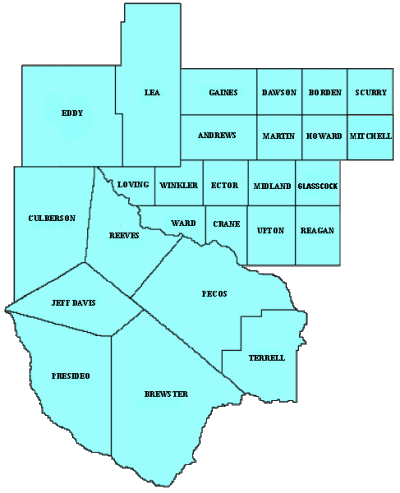
The Weather Forecast Office at Midland has one of the largest County Warning Areas (CWA) in the National Weather Service. Midland's CWA is over 51,000 square miles, encompasses a variety of topographic features and climates, and covers portions of two states. The CWA is made up of a total of 25 counties, 23 counties in west Texas, and 2 counties in southeast New Mexico Figure 1. To put the size of the CWA in perspective, it is larger than 23 U.S. states, and just slightly larger than the state of Alabama. Brewster county, at 6,193 square miles, is the largest county in the CWA, and is larger than several states.
 |
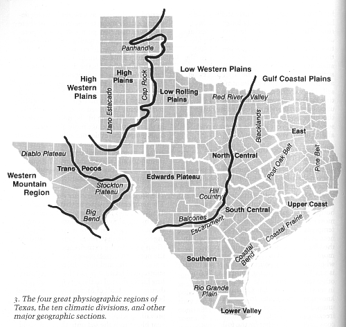
Texas has four great physiographic regions and ten climatic divisions. Although geographers do not always agree where one region or division stops and another region starts, it can be agreed that the Midland CWA has three of these regions: the High Western Plains, Low Western Plains, and the Western Mountain Region. The Midland CWA also has four climatic divisions: the Low Rolling Plains, the High Plains, the Edwards Plateau, and the Trans-Pecos. Within these divisions are major geological features that include the Permian Basin, the Cap Rock Escarpment, the Big Bend, the Stockton Plateau, and a small part of the Diablo Plateau Figure 2.
 |
1. The High Western Plains Region
The High Western Plains Region contains the High Plains division, and is separated from the Low Western Plains Region by the Cap Rock Escarpment. The southern portion of the High Plains contains parts or all of Andrews, Dawson, Ector, Gaines, Lea, Martin, and Midland counties.
a. The High Plains
The Texas/New Mexico High Plains are especially noted for their flatness. There are few areas in the United States that are as level as the High Plains, which extend from the Permian Basin northward into the Dakotas. This area is also known as the Cap Rock, or Llano Estacado (Staked Plains). Supposedly, the High Plains were so featureless that Spanish explorers had to drive stakes in the ground to find their way back. The High Plains are higher in elevation than most of Texas, and the coldest temperature ever recorded in Texas was observed on the High Plains at Seminole with -30.3C ( -23F) on 8 February 1933. This flat, treeless landscape was originally grassland, but is now primarily used for farming and ranching.
Much of the farming done on the Texas/New Mexico High Plains is cotton, with the planting season for this crop being the early spring, the windiest time of year. The combination of strong winds, plowed fields, and a dry winter/early spring result in dust storms. Most dust storms occur with the passage of strong spring cold fronts. The favored wind direction for dust storms is northwest to north; however, during below normal precipitation, dust storms will occur with winds from the west through northeast.
b. The Cap Rock Escarpment
One of the most recognizable features of the West Texas landscape is the Cap Rock Escarpment. The eastern portion of this dramatic rise in elevation runs from the Permian Basin northward through the Panhandle into Oklahoma, dividing the Texas High Plains from the Low Rolling Plains. The eastern face of the Cap Rock Escarpment is also the most pronounced face. This is partly due to erosion from a dominate southeast wind. Low level moisture can pack up against the escarpment and become a focus for thunderstorm development or intensification. The western portion of the Cap Rock Escarpment extends through much of eastern New Mexico, while the southern extension separates the Edwards Plateau from the High Plains.
c. The Permian Basin
There are few geographical features to distinguish this from the surrounding area, as the Permian Basin is a geological feature. The Permian Basin extends across a deeply buried prehistoric sea and is one of the two richest oil fields in the world. Some geographers argue that the Permian Basin is part of the Edwards Plateau, while others say it is divided between the High and Low Rolling Plains. Both southwest and northwest winds in the Permian Basin are warm winds. Southwest winds come off of the Chihuahua desert in Mexico, are hot and dry, and can result in a quick warm up. Northwest winds are downslope winds, and can help local warming by several degrees. The Permian Basin includes part or all of the counties of Andrews, Crane, Ector, Glasscock, Howard, Lea, Loving, Martin, Midland, Reagan, Ward, Winkler, and Upton.
2. The Low Western Plains Region
The Low Western Plains Region includes the Low Rolling Plains division, and the Edwards Plateau division. The Low Western Plains are separated from the High Western Plains by the Cap Rock Escarpment.
a. The Low Rolling Plains
This region is characterized by small waves in the land with some relatively flat areas. The wind direction in this area plays a significant factor in determining the type of weather. A large east through southeast fetch in the wind component is a moist and typically cooler flow. This is due to the moisture source being the Gulf of Mexico, and the cooling effect of upslope flow as the terrain increases in elevation from east to west. In the winter, this upslope flow can bring prolonged periods of low clouds, drizzle, and fog. In the spring, southeast flow can aid in the convergence of moisture along and ahead of the dryline, a boundary dividing dry air to the west from moist air to the east. The dryline enhances the potential for thunderstorm development. Summertime high temperatures are typically a few degrees warmer in the southern part of the Low Rolling Plains and in the Edwards Plateau versus the southern High Plains, due to the adiabatic cooling associated with upslope flow. The counties of Borden, Scurry, and Mitchell lie within the Low Rolling Plains.
b. The Edwards Plateau
This area is generally characterized by a slow increase in elevation from east to west, and lie within the transition boundary between the Continental Steppe, the Subtropical Steppe, and the Subtropical Arid climates. The surrounding topography of the Edwards Plateau plays a direct role in this regions climate as mountain ranges lie to the south and west. Reagan and Upton counties are included in the Edwards Plateau. Some geographers also include parts or all of Crane, Ector, Loving, Ward, and Winkler counties. An interesting feature of the landscape in this part of the area is the sand dunes, mainly in northern Crane, extreme southwest Ector, northeast Ward, and east Winkler county. Monahans Sand Hills State Park is located in northeast Ward county. In the winter and spring, this area is frequented by gusty west through north winds associated with the passage of Polar cold fronts, and to a lesser extent, Arctic cold fronts, resulting in localized blowing sand. In some areas, such as northern Crane county, sand will actually hide the roadways, while sand dunes grow tens of feet high covering property lines!
3. The Western Mountain Region (or the Mountain/Basin Region)
The Western Mountain Region includes the Trans-Pecos division, and the areas of the Big Bend, Diablo Plateau, and the Stockton Plateau.
a. The Trans-Pecos
Literally Trans-Pecos means, "Across the Pecos," and this historically refers to that part of Texas west of the Pecos River. It was in this area that the famous Judge Roy Bean held court and became the " Law west of the Pecos." Some geographers include both sides of the Pecos, the Pecos River Valley, in this description. Most geographers agree that the Trans-Pecos falls under the Western Mountain Region, but some believe that the basin part of the Trans-Pecos should be included with the Low Rolling Plains. Locally the Trans-Pecos usually refers to the Pecos River Valley and is divided into the Upper Trans-Pecos, and the Lower Trans-Pecos. The narrow description of the Trans-Pecos would include Pecos, Reeves, and Terrell counties, while the larger description would also include parts or all of Brewster, Crane, Culberson, Jeff Davis, Loving, Presidio, Ward, and Winkler counties.
b. The Mountains
The Western Mountain Region runs from the Mexican border along the Rio Grande River, up into Southeast New Mexico and is known for its rugged beauty. This region is home to several national and state parks including Big Bend National Park, Davis Mountains State Park, Guadalupe Mountains National Park, and Carlsbad National Park. The largest, and best know of these mountains, includes the Chisos, Davis, and Guadalupe Mountains.
The counties of Brewster and Presidio make up the area known as the Big Bend. Early settlers gave this area its name because the Rio Grande river makes an approximately 90 degree turn back to the northeast. Brewster county contains the Big Bend National Park which includes the Chisos Mountains. The Chisos Mountains have several peaks over 7000 feet in elevation with the highest being Emory Peak at 7825 feet. Presidio county contains the Chinati Mountains and the Southern extension of the Davis Mountains, with the majority of the Davis Mountains being located in Jeff Davis county. Davis Mountains State Park is located here and also has several peaks over 7000 feet in elevation. Mount Livermore is the highest of these peaks at 8382 feet.
North of Jeff Davis county is Culberson county, where the Guadalupe Mountain Range begins. Guadalupe Mountains National Park, in Northwest Culberson county, has the highest point in Texas, with Guadalupe Peak rising 8751 feet above sea level. These mountains extend northward into Eddy county, New Mexico, the home of Carlsbad Caverns National Park. The Guadalupe Pass, located at Guadalupe Mountains National Park, creates a localized channeling effect of west and east winds. West winds in excess of 74 kts (85 mph) are not uncommon, especially when a tight pressure gradient associated with a fast moving pacific front moves across the mountains. During spring, the winds of Guadalupe Pass are one factor that a forecaster can use in determining the potential for eastward movement of the dryline during the day. Other mountain ranges include the Del Burro, Del Norte, Glass, Santiago, Serranias, Sierra Vieja, and the Woods Hollow Mountains.
With regard to rainfall, the Chisos and Davis Mountains have the highest annual rainfall west of an Amarillo to Sanderson line, with 16 and 18 inches respectively.
c. The Basins
The climate of the Trans-Pecos Basins is of a Subtropical Arid nature, as some of the hottest temperatures in Texas as well as some of the driest condition occur here. This would include the Stockton Plateau which is made up of much of Pecos and Terrell counties, and the Diablo Plateau, which runs from western Culberson county to El Paso. The Presidio Valley is located on the west side of the Sierra Vieja and Chinati Mountains and parallels the Rio Grande River. Some of the hottest summer temperatures in Texas are found in the Presidio Valley. July's high temperatures average 37.5C (100F)!
Downslope winds from the mountains result in a 2-4C (3-5F) increase in the temperature of the basins, assuming no change in the airmass. The highest temperature ever recorded in Texas occurred in the basin area of the Trans-Pecos at Monahans with a reading of 48.7C (120F) on 28 June 1994.
4. Acknowledgment
The authors would greatly like to thank Brian Francis, SOO at NWS Midland/Odessa, for whose recommendations and reviews made this paper possible. Thanks also go to Webmaster Robert Boyd for putting this article on-line.
REFERENCES
Bomar, G.W. Texas Weather, Austin: University of Texas Press, 1995.
Dallas Morning News. 1998-1999 Texas Almanac, College Station: Texas A &M Press Consortium, 1997.
Larkin, T.J. and G.W. Bomar. Climatic Atlas of Texas, Austin: Texas Department of Water Resources, 1983.
Orton, R.B., The Climate of Texas and the Adjacent Gulf Waters, Washington: U.S. Department of Commerce, Weather Bureau, 1964.
Texas A & M University. The Roads of Texas, Fredericksburg: Shearer Publishing, 1995.

