Marine, Tropical and Tsunami Services Branch
National Program
Coastal Waters Forecast which includes the synopsis and all these zones
Special Marine Warning(s) and Marine Weather Statement(s) for these zones
Marine Weather Message for these zones
Graphical Marine Forecasts are available here. Choose the map background and forecast element and zoom in to your area of interest.
Predicted Tides and Currents for these areas
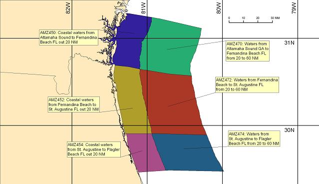
Coastal Waters Forecasts are subdivided by zone, each identified by text description and a Universal Generic Code (UGC). The different colors used in the map above have no meaning and are only intended to assist in differentiating the zones.
These forecasts are also available via e-mail
NOTICE - Check time and date of forecasts. Linked data may not represent the latest forecast.
NWS Internet is available 24 hours a day, seven days a week . Timely delivery of data and products through the Internet is not guaranteed. Official NWS dissemination systems which can provide timely delivery of data and products are listed in our DISCLAIMER.
Visit the Jacksonville, FL Forecast Office which provides links to additional products as well as regionally focused information such as point-specific marine forecasts, predicted tides and buoy observations.
Text Interface Version of this page.
US Dept of Commerce
National Oceanic and Atmospheric Administration
National Weather Service
Marine, Tropical and Tsunami Services Branch
1325 East-West Hwy, 13th floor
Communications Office
Silver Spring, MD 20910
Comments? Questions? Please Contact Us.

