National Weather Service United States Department of Commerce
Click a location below for detailed forecast.

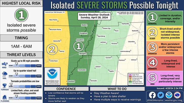
Last Map Update: Thu, Apr. 18, 2024 at 11:14:55 am CDT

National Weather Service Springfield, MONational Weather Service Paducah, KYNational Weather Service Louisville, KY
National Weather Service Little Rock, ARZoom
Out

National Weather Service Nashville, TN
National Weather Service Shreveport, LANational Weather Service Jackson, MississippiNational Weather Service Huntsville, AL


Numerous severe storms possible this afternoon and evening. Damaging winds are the primary threat. Please check back for latest details.
Showers and thunderstorms possible today. Discrete thunderstorms may develop early this afternoon ahead of a line of storms later this evening. Highs will be in the 80s.
A line of thunderstorms will approach the region tonight. Lows will be in the 50s and 60s.
A few lingering showers are possible, but most of the region will experience dry and cooler conditions. Highs will be in the upper 60s and 70s.

graphical hazard
Graphical Hazards
probabilistic
Probabilistic
current weather
Current Weather
be prepard
Being Prepared
estar preparado
Estar Preparado
safety
Weather Safety

Text Product Selector (Selected product opens in current window)

 Current Weather Observations...
Location Time
(CDT)
Weather Vsby.
(SM)
Temp.
(ºF)
Dewpt.
(ºF)
Hum.
(%)
Wind
(mph)
Wind Chill / Heat Index
(ºF)
Pres.
(in)
Memphis TN10:54Mostly Cloudy7777078SSE 10-30.01
Jackson TN10:53Overcast10766568SSE 6-30.05
Jonesboro AR10:53Mostly Cloudy9756878SSE 10-29.98
Tupelo MS10:53Mist5726990S 6-30.07
West Memphis, AR10:53Overcast9756981S 14G22-29.99
Blytheville, AR10:53Mostly Cloudy10796664S 12-30.00
Dyersburg, TN10:56Overcast10757187S 7-30.03
Olive Branch, MS10:50Overcast10756983S 9-30.02
Oxford, MS10:55Mostly Cloudy9716888VRB 6-30.07