
Showers and thunderstorms capable of producing widespread heavy rainfall will be possible across much of Puerto Rico today. Heavy rainfall will likely lead to flash, urban and small stream flooding. Some areas may face life-threatening flooding. In the Southeast U.S., strong to marginally severe thunderstorms will be possible this afternoon. Read More >
Tropical Cyclone Wind Speed Probabilities - Best Viewed with IE
|
||||||||||||||||||||||||||||||||||
|
||||||||||||||||||||||||||||||||||
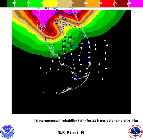
Product Description: Tropical Cyclone Wind Speed Probabilities from the National Hurricane Center (NHC) are considered an official product. They are issued with each advisory. For detailed information, you can visit NHC Tropical Cyclone Wind Speed Probabilities Products page. In this page, we provide a local scale version of the three tropical cyclone wind speed probability products available from NHC, namely, the Incremental Wind Speed Probabilities, the Onset Wind Speed Probabilities, and the Cumulative Wind Speed Probabilities. In addition to the explanation below, you should look at these also in the context of how they are trending from advisory to advisory, are they holding steady, trending up, or trending down? 1.) What are the chances that tropical storm or hurricane conditions will be experienced during a particular period at my location? - This is the question that the incremental wind speed probabilities shown above can answer. The incremental wind speed probabilities (as shown above) for tropical storms or hurricanes represent the chances that wind speeds will equal or exceed 34 knots/39 mph or 64 knots/74 mph, respectively, during a 12 hour forecast period. You can access them by clicking on TS Incremental Wind Speed Probabilities or HR Incremental Wind Speed Probabilities above. As shown above the 12 hour forecast periods end at 8/7 AM (EDT/EST) for night time and 8/7 PM (EDT/EST) for day time periods. Since NHC forecasts go out 5 days, these probabilities are available for ten 12 hours forecast periods. The first loop that loads above by default is the incremental wind speed probabilities for tropical storms from period 1 to period 9 or 10 depending on the advisory. For information purposes, you might ask yourself how do I know the significance of the incremental wind speed probabilities? Verification studies have shown that the following incremental wind speed thresholds are critical values to look for as a function of forecast period (image number in the loop above goes from period 1 being the first to the last period which chould be period 9 or 10 depending on the advisory. The thresholds for each forecast period are shown below:
2.) What are the chances that tropical storm or hurricane conditions will begin during a particular time period at my location? And given that, what is the most likely period of onset of these conditions? - These are the questions that the onset wind speed probabilities shown above can answer. The onset wind speed probabilities (as shown above) for tropical storms or hurricanes represent the chance that wind speeds equal to or greater than 34 knots/39 mph or 64 knots/74 mph, respectively, will begin during a given 6 hours time period. You can access them by clicking on TS Onset Wind Speed Probabilities or HR Onset Wind Speed Probabilities above. The 6 hours forecast periods end at 2/1 AM (EDT/EST), 8/7 AM (EDT/EST), 2/1 PM (EDT/EST), 8/7 PM (EDT/EST), etc, out to 120 hours or the 5 days period of NHC forecasts. Important to note is that near zero onset probabilities does not mean little chance of the said conditions being experienced. Again, these probabilities simply mean the chances that said conditions will begin during a given period. 3.) What are the chances that tropical storm or hurricane conditions will occur during the next 5 days with this event at my location? - This is the question that the cumulative wind spped probabilities shown above can answer. The cumulative wind speed probabilities (as shown above) for tropical storms or hurricanes represent the chance of wind speeds equal to or greater than 34 knots/39 mph or 64 knots/74 mph, respectively, during the next 120 hours or 5 days period of NHC forecasts. THEREFORE, THERE IS ONLY ONE TIME FRAME FOR THESE PROBABILITIES (NO LOOPING). They DO NOT provide any information about the timing of the event. You can access them by clicking on TS Cumulative Wind Speed Probabilities or HR Cumulative Wind Speed Probabilities above. These are the same probabilities that NHC posts on their graphics page with each advisory. |
||||||||||||||||||||||||||||||||||


 Follow us on YouTube