Event Overview
Hurricane Irene was a large and powerful Atlantic hurricane that left extensive flood and wind damage along its path through the Caribbean, the United States East Coast and as far north as Canada (Figure 1). Irene made landfall near Cape Lookout, North Carolina at around 7:30 AM EDT on August 27, 2011 as a strong category 1 storm (Figure 2). Irene caused 5 deaths in North Carolina. On the evening of August 26, well ahead of landfall, Hurricane Irene also spawned several tornadoes. One EF-2 tornado near Columbia in Tyrrell County demolished at least 4 homes and overturned cars.
Precipitation totals associated with Irene were particularly high (Figure 3) with totals ranging from around 5 inches over the Northern Outer Banks, to around 15 inches in Beaufort County. Bunyan in Beaufort County reported 15.66 inches. Doppler Radar estimated totals of over 17 inches in portions of Beaufort, Craven and Pamlico Counties (Figure 4). Extensive storm surge and wind damage also occurred with Irene. The peak wind gust recorded was 115 mph at the Cedar Island Ferry Terminal in Carteret County as the eye was moving ashore (Figure 5). Trees were down throughout eastern North Carolina and thousands were left without electricity. Ocean and Sound overwash created numerous breaches of Highway 12 along the Outer Banks.
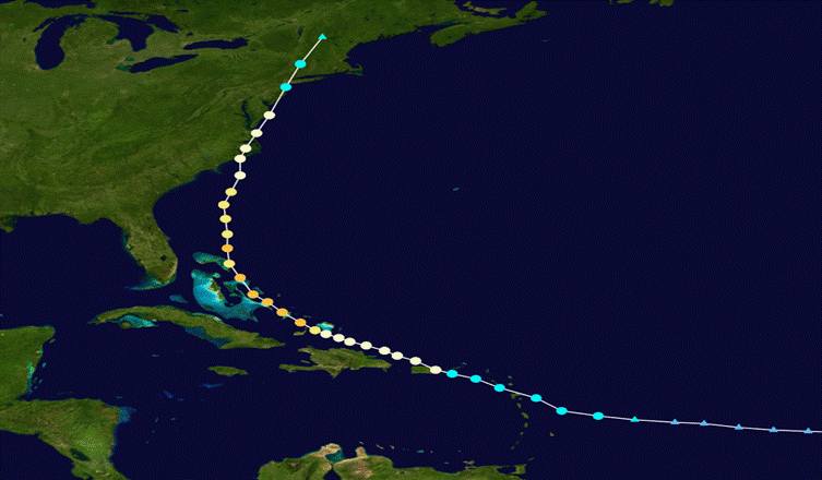
Figure 1. Track of Hurricane Irene, August 20 through 29, 2011. (Source: National Hurricane Center)
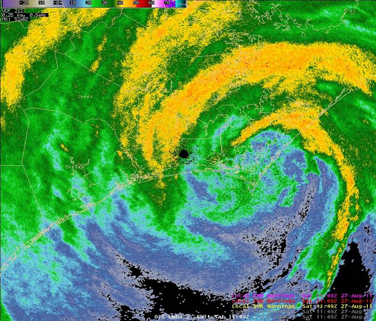
Figure 2. Eye of Hurricane Irene making landfall near Cape Lookout, NC at 749 AM EDT, August 27, 2011
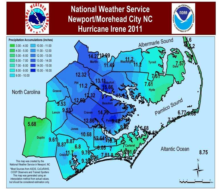
Figure 3. Rainfall Totals from Hurricane Irene, August 26-27, 2011
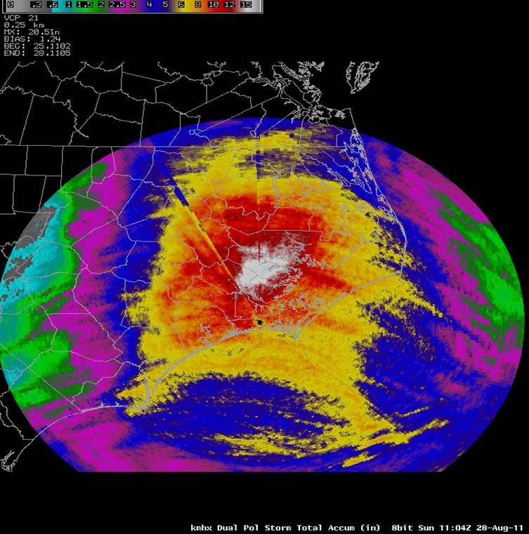
Figure 4. Newport/Morehead City Doppler Radar Estimated Rainfall for Hurricane Irene. Note the large white area of over 17 inches over Beaufort, Craven and Pamlico Counties.
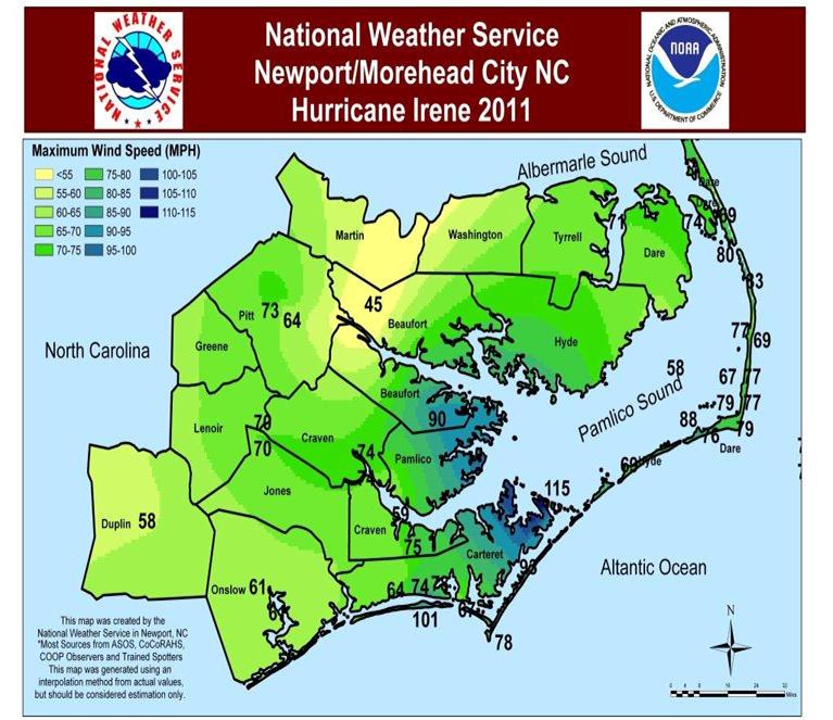
Figure 5. Peak Wind Gusts from Hurricane Irene, August 27, 2011.The peak wind gust recorded was 115 mph at the Cedar Island Ferry Terminal in Carteret County.
Evolution and Impacts
Hurricane Irene evolved from a tropical wave that exited the African coast on August 15, 2011. With a favorable environment ahead of the wave, a Tropical Depression formed on August 20 as the wave approached the Lesser Antilles. By 23Z on August 20, the depression was upgraded to Tropical Storm Irene. On August 21, the surface center reformed closer to the deepest convection, as an anticyclone aloft provided supportive outflow over the cyclone. With the improved structure, as well as light wind shear and high sea surface temperatures, Irene was forecast to strengthen to near hurricane force prior to landfall in Hispaniola. Over the subsequent day (August 22), while passing near the island of Saint Croix in the U.S. Virgin Islands, Irene moved toward Puerto Rico, more northward than initially expected, where it underwent a considerable increase in strength and organization. Hours later, Irene moved ashore, approaching from the southeast at landfall near Punta Santiago, Puerto Rico, with estimated sustained winds of 70 mph. Despite the storm's interaction with land, radar imagery showed a ragged eye-like feature, and Doppler radar data indicated wind speeds in excess of hurricane force. Just after its initial landfall, Irene was accordingly upgraded to a Category 1 hurricane, the first of the 2011 Atlantic hurricane season.
After briefly weakening on August 23, Irene began to develop a distinct eye encircled by an area of deepening convection the next morning. Moving erratically through the southeast Bahamas over very warm waters, Irene quickly expanded as its outflow aloft became very well established. The hurricane intensified into a Category 3 major hurricane as it recurved toward the northwest along a weakness in the subtropical ridge. Irene would gradually weaken to a strong Category 1 storm as it approached the North Carolina coast as dry air wrapped into the hurricane.
Tropical-storm force winds began to affect the Outer Banks and Crystal Coast during the early evening hours of August 26. Additionally, Irene spawned several tornadoes during the late evening hours of August 26, producing significant damage in Tyrrell, Washington and Beaufort Counties. Figure 6 shows the strong rotational couplet associated with an EF-1 tornado near Creswell, North Carolina around 1055 pm August 26.
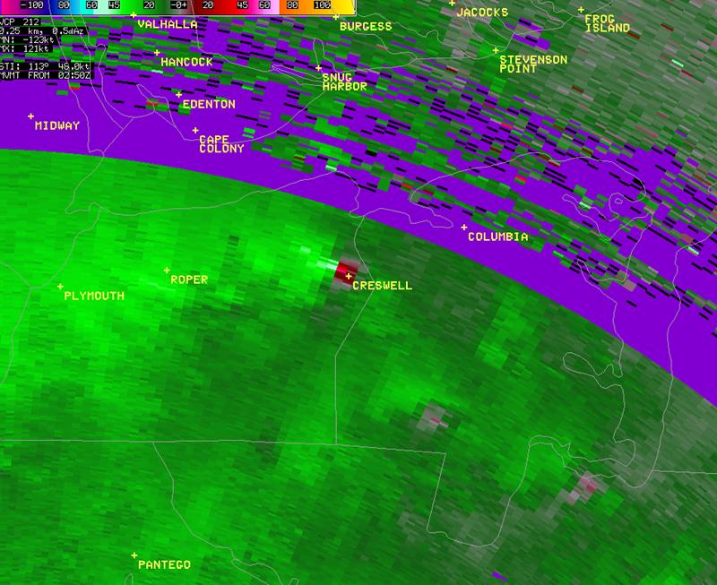
Figure 6. Strong Rotational Couplet in the Doppler velocities from Creswell, NC around 1055 pm August 26. This couplet produced an EF-1 tornado.
Irene made landfall between 7:30 and 8 AM EDT Saturday August 27 near Cape Lookout, North Carolina. As the eye wall moved ashore, wind gusts to 115 mph were observed at the Cedar Island Ferry Terminal. The lowest pressure observed with the landfall of Irene was at Beaufort (Figure 7) with 28.11 inches of mercury or around 951 millibars at 8:56 AM. Strong winds and driving rains pounded most of Eastern North Carolina into the mid-afternoon hours on Saturday. As the eye moved inland, strong westerly winds on the backside of the storm gusted to near 100 mph at Atlantic Beach around 10:30 AM. Torrential rainfall amounts in excess of 10 inches were widespread. Storm surge levels of over 10 feet were observed at Ocracoke and several breaches of Highway 12 were noted all along the Outer Banks. A total of 5 people were killed in North Carolina as the result of Irene.
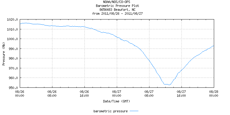
Figure 7. Barometric Pressure Graph from Beaufort, NC August 26-27, 2011. (Courtesy: National Ocean Service)
PUBLIC INFORMATION STATEMENT
NATIONAL WEATHER SERVICE NEWPORT/MOREHEAD CITY NC
550 PM EDT SUN AUG 28 2011
...PUBLIC INFORMATION STATEMENT...
THE FOLLOWING ARE UNOFFICIAL OBSERVATIONS TAKEN DURING HURRICANE IRENE.
APPRECIATION IS EXTENDED TO HIGHWAY DEPARTMENTS...COOPERATIVE
OBSERVERS...SKYWARN SPOTTERS...COCORAHS OBSERVERS AND MEDIA FOR
THESE REPORTS. THIS SUMMARY IS ALSO AVAILABLE ON OUR HOME PAGE AT
WEATHER.GOV/NEWPORT/
***********************PEAK WIND GUST***********************
LOCATION MAX WIND TIME/DATE COMMENTS
GUST OF
MPH MEASUREMENT
NORTH CAROLINA
...BEAUFORT COUNTY...
WASHINGTON 45 435 AM 8/27 KOCW-DOWN AT 455 AM (8/27)
AURORA 90 845 AM 8/27 PCS PHOSPHATE
...CARTERET COUNTY...
CEDAR ISLAND 115 750 AM 8/27 CEDAR ISLAND FERRY TERM
BEAUFORT 70 1003 AM 8/27 KMRH-DOWN AT 1003 AM(8/27)
FORT MACON 92 1110 AM 8/27 WEATHERFLOW
CAPE LOOKOUT 78 400 AM 8/27 WEATHERFLOW
MOREHEAD CITY 78 329 AM 8/27 MHC POLICE DEPT
MOREHEAD CITY 70 1130 AM 8/27 WEATHERFLOW-DOWN AT 1103 AM(8/27)
NEWPORT 64 849 AM 8/27 NWS NEWPORT
STACY 93 408 AM 8/27 TRAINED SPOTTER
BEAUFORT 77 641 AM 8/27 TRAINED SPOTTER
NEWPORT 74 1015 AM 8/27 TRAINED SPOTTER
BEAUFORT 76 1101 AM 8/27 TRAINED SPOTTER
ATLANTIC BEACH 101 1035 AM 8/27 TRAINED SPOTTER
...CRAVEN COUNTY...
CHERRY POINT 75 1154 PM 8/27 KNKT
NEUSE RIVER 59 125 AM 8/27 WEATHERFLOW-DOWN AT 135 AM (8/27)
NEW BERN 74 751 AM 8/27 KEWN-DOWN AT 849 AM (8/27)
...DARE COUNTY...
MANTEO 74 755 AM 8/27 KMQI
FRISCO WOODS 76 610 AM 8/27 WEATHERFLOW-DOWN AT 1010 PM(8/28)
HATTERAS HIGH 68 710 AM 8/27 WEATHERFLOW-DOWN AT 1020 PM(8/27)
HATTERAS 88 851 AM 8/27 KHSE
BUXTON 79 930 AM 8/27 WEATHERFLOW-DOWN AT 920 PM (8/27)
MANTEO CSWY 69 1118 AM 8/27 WEATHERFLOW
ALLIGATOR BRIDGE 66 847 AM 8/27 WEATHERFLOW
OREGON INLET 78 856 AM 8/27 WEATHERFLOW
AVON (OCEAN SIDE) 77 725 AM 8/27 WEATHERFLOW-DOWN AT 903 AM (8/26)
AVON (SOUND SIDE) 67 635 AM 8/27 WEATHERFLOW-DOWN AT 836 AM (8/27)
WAVES 57 713 AM 8/27 WEATHERFLOW
SALVO 69 755 AM 8/27 WEATHERFLOW
BUXTON 79 600 AM 8/27 WEATHERFLOW
PAMLICO SOUND 58 1050 AM 8/27 WEATHERFLOW-DOWN AT 1130 PM(8/26)
REAL SLICK 77 1020 AM 8/27 WEATHERFLOW-DOWN AT 654 PM (8/27)
WAVES 63 725 AM 8/27 WEATHERFLOW-DOWN AT 921 AM (8/27)
OREGON INLET 77 210 PM 8/27 WEATHERFLOW-DOWN AT 618 PM (8/27)
MANTEO 74 435 PM 8/27 WEATHERFLOW-DOWN AT 537 PM (8/27)
MANTEO CSWY 68 1015 AM 8/27 WEATHERFLOW-DOWN AT 537 PM (8/27)
JOCKEYS RIDGE 69 400 PM 8/27 WEATHERFLOW-DOWN AT 646 PM (8/27)
PEA ISLAND 83 950 AM 8/27 KPEI
DUCK 85 1036 AM 8/27 DUCK COE PIER
...DUPLIN COUNTY...
2 N KENANSVILLE 58 915 AM 8/27 KDPL
...HYDE COUNTY...
OCRACOKE 69 439 AM 8/27 WEATHERFLOW-DOWN AT 616 AM (8/27)
...JONES COUNTY...
WYSE FORKS 70 1131 AM 8/27 TRAINED SPOTTER
...ONSLOW COUNTY...
JACKSONVILLE 50 355 AM 8/27 KOAJ-DOWN AT 415 AM (8/27)
NEW RIVER 61 356 AM 8/27 KNCA-DOWN AT 429 AM (8/27)
JACKSONVILLE 94 615 AM 8/27 TRAINED SPOTTER
...PITT COUNTY...
GREENVILLE 64 835 AM 8/27 KPGV
GREENVILLE 73 700 AM 8/27 PITT EOC
...TYRRELL COUNTY...
ALLIGATOR BRIDGE 71 1050 AM 8/27 WEATHERFLOW-DOWN AT 328 PM (8/27)
...NDBC BUOY...
DUCK PIER 79 512 PM 8/27 DUKN7
OREGON INLET MARINA 80 400 PM 8/27
HATTERAS 79 536 AM 8/27
CAPE LOOKOUT 78 400 AM 8/27 CLKN7
BEAUFORT 67 612 AM 8/27 BFTN7
41036 69 820 AM 8/27
***********************BAROMETRIC PRESSURE***********************
LOCATION LOWEST PRESSURE DATE/ COMMENTS
INCHES TIME
HATTERAS 28.65 8/27 135 PM KHSE
BEAUFORT 28.11 8/27 856 AM KMRH
CHERRY POINT 28.18 8/27 854 AM KNKT
GREENVILLE 28.84 8/27 1235 PM KPGV
...NDBC BUOYS...
41036 28.25 8/27 620 AM
44014 29.20 8/27 1150 AM
CLKN7 28.15 8/27 800 AM
ORIN7 28.80 8/27 1218 PM
*******************STORM TOTAL RAINFALL REPORTS***********************
LOCATION TOTAL PRECIP COMMENTS
...BEAUFORT...
BUNYAN 15.66 RAWS - BNYN7
WASHINGTON 13.11 HYDRO - TRAN7
...CARTERET COUNTY...
CROATAN FOREST 11.13 RAWS - NPTN7
NEWPORT 10.41 WFO MHX
NEWPORT 9.41 NEWPORT 0.2 SW
MOREHEAD CITY 8.11 MOREHEAD CITY 6.0 WNW
NEWPORT 7.81 NEWPORT 2.0 WSW
BEAUFORT 7.00 BEAUFORT 5.3 N
CEDAR ISLAND 6.68 RAWS - TS788
MOREHEAD CITY 6.65 MOREHEAD CITY 0.6 NW
BEAUFORT 6.31 ASOS - KMRH
...CRAVEN COUNTY...
NEW BERN 14.79 NEW BERN 1.3 NNE
NEW BERN 12.86 RAWS - NBRN7
HAVELOCK 10.70 HAVELOCK 1.4 SW
NEW BERN 7.79 ASOS - KEWN
TRENT WOODS 5.94 TRENT WOODS 1.3 SSE
PERRYTOWN 5.04 COOP - PYTN7 (8/27)
...DARE COUNTY...
DARE BOMB RANGE 7.57 RAWS - STCN7
HATTERAS 6.77 ASOS - KHSE
KILL DEVIL HILLS 2.43 KILL DEVIL HILLS 0.9 WNW
...DUPLIN COUNTY...
BEAULAVILLE 9.61 BEAULAVILLE 0.5 NE
MOUNT OLIVE 5.68 COOP - MTON7
MOUNT OLIVE 4.66 MOUNT OLIVE 2.4 SW
...HYDE COUNTY...
FAIRFIELD 7.61 RAWS - TS161
OCRACOKE 2.72 COOP - OCRN7 (8/27)
...LENOIR COUNTY...
KINSTON 9.53 KINSTON 3.7 WNW
...MARTIN COUNTY...
WILLIAMSTON 14.27 WILLIAMSTON 0.9 SSW
...ONSLOW COUNTY...
JACKSONVILLE 11.70 JACKSONVILLE 5.5 WSW
SWANSBORO 9.76 SWANSBORO 3.3 NW
CAMP LEJUENE 9.57 HYDRO - CLJN7
HUBERT 9.36 HUBERT 4.3 SE
HUBERT 9.12 HUBERT 4.9 SE
RICHLANDS 8.87 RICHLANDS 2.8 SSE
JACKSONVILLE 8.36 JACKSONVILLE 1.7 W
HOFMANN FOREST 7.95 RAWS - HFMN7
JACKSONVILLE 6.80 COOP - JEON7
...PAMLICO COUNTY...
BAYBORO 15.74 COOP - BAYN7
...PITT COUNTY...
GRIFTON 12.69 HYDRO - GRTN7
GREENVILLE 12.32 GREENVILLE 7.1 SSE
GREENVILLE 11.64 COOP - GREN7
GREENVILLE 10.57 GREENVILLE 8.2 SSE
GREENVILLE 10.50 HYDRO - PGVN7
GREENVILLE 10.25 GREENVILLE 1.1 S
WINTERVILLE 9.74 WINTERVILLE 3.5 W
GREENVILLE 8.69 GREENVILLE 1.4 SE
GREENVILLE 7.23 AWOS - KPGV
...WASHINGTON COUNTY...
POCOSIN LAKES 11.20 HYDRO - POCN7
$$
Sources –
National Hurricane Center
National Ocean Service
WITN TV
WCTI TV
Wikipedia
GR2 Analyst Software
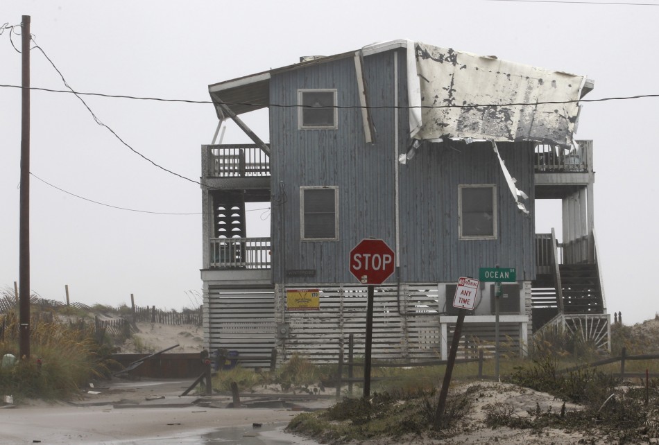
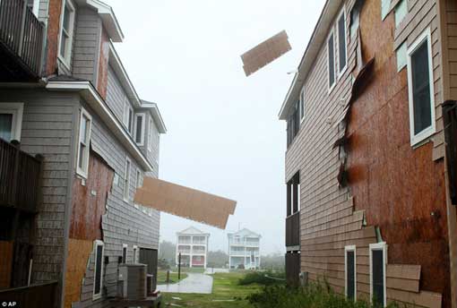
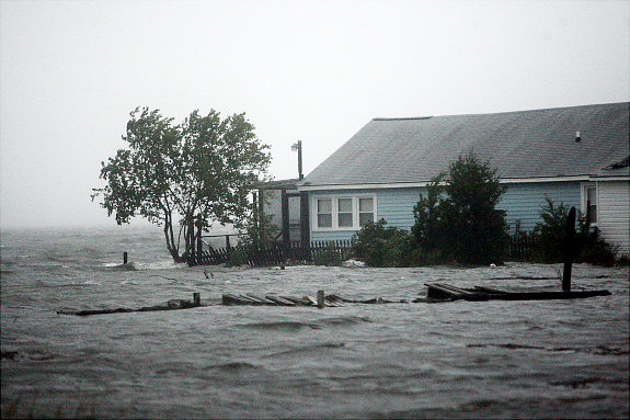
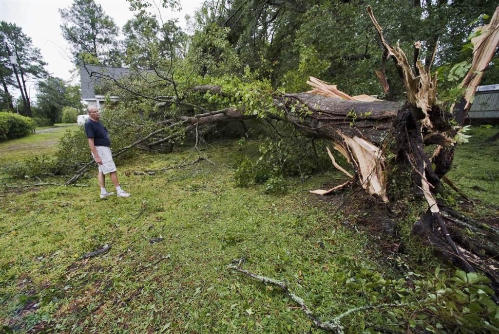
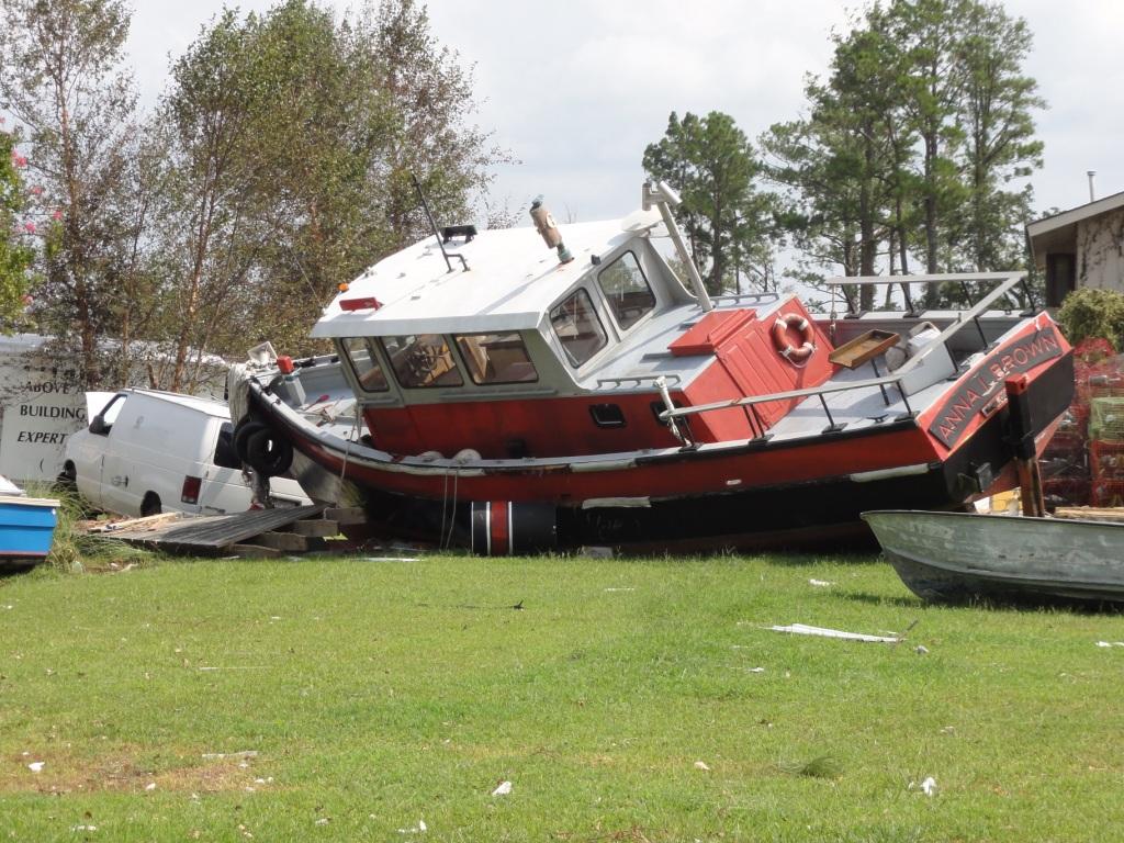
Damage Pictures from Eastern North Carolina
Photos courtesy of: Storm Survey Team

Case Study Team:
MHX Case Study Team


.png) Surf Forecast/Rip Currents
Surf Forecast/Rip Currents Map View
 Weather Hazard Briefing (when applicable)
 Forecaster Discussion
 Marine
 Text Products
.png) Skywarn
Skywarn Submit Storm Reports
 Coastal Flood
 Follow us on YouTube