TROPICAL STORM HERMINE, SEPTEMBER 2-3, 2016
Overview
Hermine was the first hurricane to make landfall in Florida since Hurricane Wilma in 2005. It was the ninth tropical depression, and fourth hurricane of the 2016 season. Hermine developed from a tropical wave in the Caribbean. On August 29, Hermine intensified to a Category 1 hurricane in the south central Gulf of Mexico before making landfall in the northeast Florida Panhandle near Cedar Key on September 2. The storm weakened quickly and transitioned to a post-tropical cyclone before moving off the coast over the Outer Banks on September 3. The system produced very heavy rainfall, rip currents and three tornadoes in eastern North Carolina.
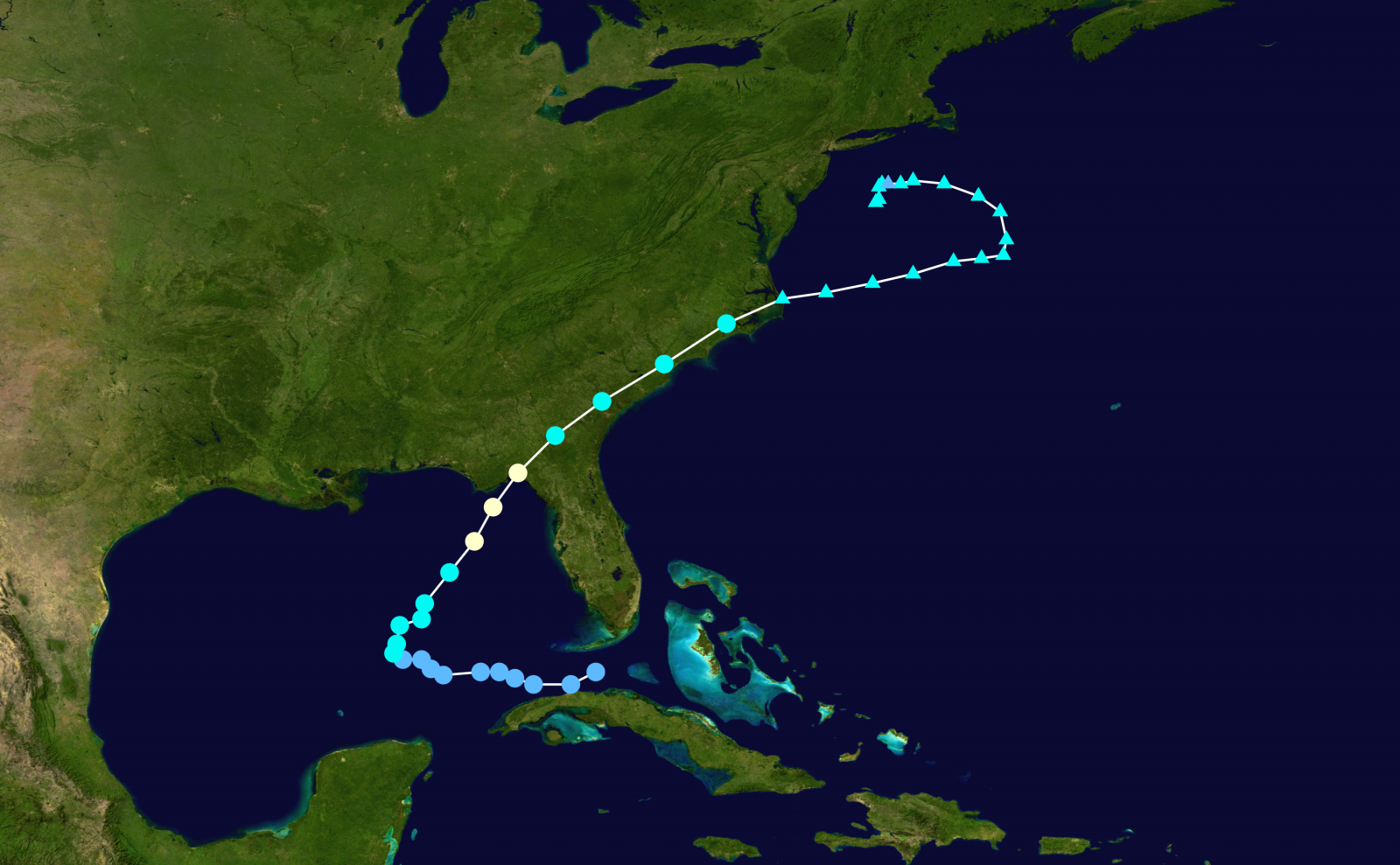
Track of Hermine, August 28 to September 6, 2016
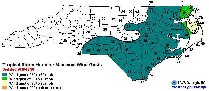
Peak Wind Gusts Associated with Tropical Storm Hermine (Courtesy NWS Raleigh, NC.
...Rainfall and Peak Wind Gust reports from Hermine...

Location                     Amount    Time/Date       Provider

...North Carolina...

...Beaufort County...
Bath 0.7 N                   5.85 in   0700 AM 09/03   COCORAHS
Bunyan Raws                  4.60 in   0818 AM 09/03   RAWS
2 ESE River Road             2.05 in   0930 PM 09/02   COCORAHS

...Carteret County...
Marshallberg                 8.59 in   0730 AM 09/03   COCORAHS
Morehead City 1.4 NNW        7.48 in   0730 AM 09/03   COCORAHS
Morehead City                6.99 in   0800 AM 09/03   COCORAHS
Newport 2.5 W                6.66 in   0730 AM 09/03   COCORAHS
Cape Carteret                6.05 in   0700 AM 09/03   COCORAHS
6 WNW Otway                  6.00 in   0800 AM 09/03   COCORAHS
2 N Beaufort                 5.77 in   0700 AM 09/03   COCORAHS
Beaufort (mrh Asos)          5.59 in   0758 AM 09/03   ASOS
1 NNW Beaufort               5.45 in   0645 AM 09/03   COCORAHS
3 WNW Morehead City          5.38 in   0700 AM 09/03   COCORAHS
1 E Pine Knoll Shores        5.25 in   0700 AM 09/03   COCORAHS
Croatan Raws                 5.23 in   0905 AM 09/03   RAWS
1 NE Cape Carteret           5.09 in   0700 AM 09/03   COCORAHS
2 SSE Cedar Point            4.95 in   0600 AM 09/03   COCORAHS
Newport/morehead City Wfo    4.90 in   1200 AM 09/03   COOP
2 NNW Pine Knoll Shores      4.84 in   0700 AM 09/03   COCORAHS
2 NNW Pine Knoll Shores      4.33 in   0700 AM 09/03   COCORAHS
Cedar Island Raws            13.34 in  0825 AM 09/03   RAWS

...Craven County...
6 ESE Cove City              7.57 in   0700 AM 09/03   COCORAHS
Trent Woods                  6.96 in   0649 AM 09/03   COCORAHS
Trent Woods                  6.67 in   0700 AM 09/03   COCORAHS
1 NNE New Bern               6.49 in   0700 AM 09/03   COCORAHS
New Bern 8.9 SSE             6.03 in   0800 AM 09/03   COCORAHS
1 SSE Trent Woods            5.94 in   0700 AM 09/03   COCORAHS
Perrytown (coop)             5.94 in   0800 AM 09/03   COOP
River Bend                   5.83 in   0700 AM 09/03   COCORAHS
1 SE Trent Woods             5.76 in   0700 AM 09/03   COCORAHS
3 ENE James City             5.67 in   0700 AM 09/03   COCORAHS
New Bern 7.7 NE              5.62 in   0700 AM 09/03   COCORAHS
3 E Bridgeton                5.60 in   0700 AM 09/03   COCORAHS
Cherry Point (nkt Asos)      5.45 in   0754 AM 09/03   ASOS
2 ENE James City             5.18 in   0600 AM 09/03   COCORAHS
2 S James City               5.13 in   0700 AM 09/03   COCORAHS
4 SSE Minnesott Beach        5.10 in   0800 AM 09/03   COCORAHS
New Bern (ewn Asos)          4.72 in   0754 AM 09/03   ASOS
2 S James City               3.96 in   0700 AM 09/03   COCORAHS

...Dare County...
1 WNW Manteo                 7.62 in   0700 AM 09/03   COCORAHS
Frisco (hse Asos)            6.05 in   0759 AM 09/03   ASOS
Frisco 2nne (coop)           5.98 in   0730 AM 09/03   COOP
Dare Bomb Range Raws         5.41 in   0828 AM 09/03   RAWS
Dare Co Gnry Ran (2dp Awos)  0.11 in   0756 AM 09/03   AWOS

...Hyde County...
Fairfield Raws               7.34 in   0817 AM 09/03   RAWS

...Jones County...
1 E River Bend               5.18 in   0625 AM 09/03   COCORAHS

...Lenoir County...
1 NW Kinston                 7.00 in   0800 AM 09/03   COCORAHS
Kinston 7 Se (coop)          5.76 in   0730 AM 09/03   COOP
4 W Kinston                  5.73 in   0700 AM 09/03   COCORAHS
3 WNW Kinston                5.30 in   0700 AM 09/03   COCORAHS

...Martin County...
6 SW Jamesville              6.30 in   0700 AM 09/03   COCORAHS

...Onslow County...
7 NE Maple Hill              7.65 in   0700 AM 09/03   COCORAHS
3 NW Swansboro               7.00 in   0700 AM 09/03   COCORAHS
Sandy Run Raws               6.99 in   0819 AM 09/03   RAWS
Richlands (oaj Awos)         6.83 in   0756 AM 09/03   AWOS
1 ENE Jacksonville           6.62 in   0700 AM 09/03   COCORAHS
Richlands                    6.46 in   0700 AM 09/03   COCORAHS
Richlands 2.8 NW             6.44 in   0800 AM 09/03   COCORAHS
1 N Swansboro                6.35 in   0830 AM 09/03   COCORAHS
4 WSW Swansboro              6.32 in   0730 AM 09/03   COCORAHS
Hoffman Raws                 6.32 in   0910 AM 09/03   RAWS
5 SSW Richlands              6.26 in   0630 AM 09/03   COCORAHS
Jacksonville (nca Asos)      6.16 in   0756 AM 09/03   ASOS
Jacksonville (coop)          6.00 in   0800 AM 09/03   COOP

...Pamlico County...
Lowland                      7.12 in   0700 AM 09/03   COCORAHS
2 WSW Oriental               6.10 in   0800 AM 09/03   COCORAHS
3 SSE Stonewall              5.73 in   0700 AM 09/03   COCORAHS
5 NW Arapahoe                5.69 in   0806 AM 09/03   COCORAHS
5 NE Oriental                5.30 in   0700 AM 09/03   COCORAHS

...Pitt County...
4 WNW Greenville             7.27 in   0700 AM 09/03   COCORAHS
3 W Greenville               7.14 in   0800 AM 09/03   COCORAHS
1 ENE Greenville             7.06 in   0800 AM 09/03   COCORAHS
2 WSW Greenville             6.74 in   0600 AM 09/03   COCORAHS
2 SE Greenville              6.73 in   0800 AM 09/03   COCORAHS
2 NW Winterville             6.47 in   0700 AM 09/03   COCORAHS
1 N Greenville               6.44 in   0845 AM 09/03   HADS
4 SE Falkland                6.40 in   0700 AM 09/03   COCORAHS
2 ENE Winterville            6.34 in   0800 AM 09/03   COCORAHS
Greenville (coop)            5.87 in   1200 AM 09/03   COOP
3 W Winterville              5.81 in   0700 AM 09/03   COCORAHS
4 ESE Winterville            5.08 in   0700 AM 09/03   COCORAHS
Winterville 1.0 ENE          4.95 in   0700 AM 09/03   COCORAHS
Fountain                     3.72 in   0700 AM 09/03   COCORAHS

...Tyrrell County...
Gum Neck Coop                8.35 in   0600 AM 09/03   COOP

...Washington County...
Pocosin Lakes Raws           6.42 in   0817 AM 09/03   RAWS

...Maritime Stations...
2 NNW Marshallberg           7.17 in   0800 AM 09/03   COCORAHS
2 W Buxton                   5.18 in   0730 AM 09/03   COCORAHS
3 E Bayboro                  4.52 in   0700 AM 09/03   COOP


----------------------------------------------------------------


Location                     Speed     Time/Date       Provider

...North Carolina...

...Beaufort County...
Washington (ocw Awos)        44 MPH    0600 AM 09/03   AWOS
Bunyan Raws                  44 MPH    0818 AM 09/03   RAWS
5 NE Aurora (nc Econet)      25 MPH    0700 AM 09/03   NC-ECONET

...Carteret County...
Fort Macon (wxflow)          40 MPH    1243 AM 09/03   WXFLOW
Cedar Island Raws            40 MPH    1125 PM 09/02   RAWS
Beaufort (mrh Asos)          36 MPH    0843 AM 09/03   ASOS

...Craven County...
Cherry Point (nkt Asos)      41 MPH    0942 PM 09/02   ASOS
New Bern (ewn Asos)          38 MPH    1002 PM 09/02   ASOS

...Dare County...
Stumpy Point (wxflow)        62 MPH    0123 AM 09/03   WXFLOW
Buxton (wxflow)              61 MPH    0131 AM 09/03   WXFLOW
Manteo (mqi Awos)            59 MPH    0420 AM 09/03   AWOS
Oregon Inlet (wxflow)        56 MPH    0303 AM 09/03   WXFLOW
Frisco (hse Asos)            56 MPH    0125 AM 09/03   ASOS
Dare Co Gnry Ran (2dp Awos)  55 MPH    0206 AM 09/03   AWOS
5 ESE Wanchese               54 MPH    0222 AM 09/03   WXFLOW
Kill Devil Hills (ffa Awos)  52 MPH    0520 AM 09/03   AWOS
Khk Resort (wxflow)          52 MPH    0210 AM 09/03   WXFLOW
Dare Bomb Range Raws         47 MPH    0328 AM 09/03   RAWS
Avon (wxflow)                46 MPH    0138 AM 09/03   WXFLOW
Hatteras High (wxflow)       45 MPH    0930 PM 09/02   WXFLOW
Nags Head (wxflow)           36 MPH    0503 AM 09/03   WXFLOW

...Duplin County...
Kenansville (dpl Awos)       33 MPH    1200 AM 09/03   AWOS
5 W Teachey                  29 MPH    1100 PM 09/02   NC-ECONET

...Hyde County...
Fairfield Raws               38 MPH    1117 PM 09/02   RAWS

...Lenoir County...
Kinston (iso Awos)           41 MPH    1220 AM 09/03   AWOS
2 NNE Kinston                35 MPH    0200 AM 09/03   NC-ECONET

...Martin County...
Williamston (nc Econet)      23 MPH    0300 AM 09/03   NC-ECONET

...Onslow County...
Jacksonville (nca Asos)      44 MPH    0708 PM 09/02   ASOS
Richlands (oaj Awos)         33 MPH    0841 PM 09/02   AWOS
Hoffman Raws                 28 MPH    0910 PM 09/02   RAWS

...Pitt County...
Greenville (pgv Awos)        43 MPH    0450 AM 09/03   AWOS

...Washington County...
Pocosin Lakes Raws           43 MPH    0117 AM 09/03   RAWS
2 SW Roper (nc Econet)       37 MPH    0700 AM 09/03   NC-ECONET

...Maritime Stations...
Duck Frf Research Pier       79 MPH    0630 AM 09/03   NWLON
Alligator River Br (wxflow)  74 MPH    0834 AM 09/03   WXFLOW
Real Slick (wxflow)          65 MPH    0210 AM 09/03   WXFLOW
Jennettes Pier (wxflow)      64 MPH    0330 AM 09/03   WXFLOW
Pamlico Sound (wxflow)       63 MPH    0934 PM 09/02   WXFLOW
Diamond Shoals Buoy          54 MPH    0450 AM 09/03   MARITIME
Ocracoke (wxflow)            54 MPH    0910 PM 09/02   WXFLOW
Oregon Inlet                 52 MPH    0230 AM 09/03   NWLON
Buoy 30se New River Inlet    47 MPH    0608 AM 09/03   MARITIME
Avon Sound (wxflow)          46 MPH    0121 AM 09/03   WXFLOW
Frisco Woods (wxflow)        45 MPH    1240 AM 09/03   WXFLOW
Cape Lookout                 43 MPH    0100 AM 09/03   MARITIME
Beaufort                     41 MPH    1206 AM 09/03   NOS-NWLON
3 W Otway                    36 MPH    1207 AM 09/03   WXFLOW

Observations are collected from a variety of sources with varying
equipment and exposures. Not all data listed are considered official.

$$
|
...Multiple Tornadoes Confirmed on Sept 2, 2016...

...Tornado Confirmed Near Straits in Carteret County North
Carolina...

Location...Straits in Carteret County North Carolina
Date...September 2, 2016
Estimated Time...920 PM EDT
Maximum EF-Scale Rating...EF1
Estimated Maximum Wind Speed...95 MPH
Maximum Path Width...50 yards
Path Length...240 yards
Beginning Lat/Lon...34.724N / 76.573W
Ending lat/Lon...34.726N / 76.574W
* Fatalities...0
* Injuries...0

* The information in this statement is preliminary and subject to
  change pending final review of the event(s) and publication in
  NWS Storm Data.

...Summary...
The National Weather Service in Newport/Morehead City NC has
confirmed a tornado near Straits in Carteret County North
Carolina on September 2, 2016.

The tornado briefly touched down near Harkers Island Road just
north of Harkers Island bridge causing significant damage to a
small boat storage facility, minor siding and window damage to a
mobile home, and collapsed the garage door and caused moderate
roof damage to a small business. In addition, several trees had
their trunks snapped or had large branches broken.

This information can also be found on our website at
www.weather.gov/mhx.

For reference...the Enhanced Fujita Scale classifies tornadoes
into the following categories:

EF0...wind speeds 65 to 85 mph.
EF1...wind speeds 86 to 110 mph.
EF2...wind speeds 111 to 135 mph.
EF3...wind speeds 136 to 165 mph.
EF4...wind speeds 166 to 200 mph.
EF5...wind speeds greater than 200 mph.

&&

...Tornado Confirmed Near Marshallberg in Carteret County North
Carolina...

Location...Marshallberg in Carteret County North Carolina
Date...September 2, 2016
Estimated Time...923 PM EDT
Maximum EF-Scale Rating...EF1
Estimated Maximum Wind Speed...95 MPH
Maximum Path Width...50 yards
Path Length...600 yards
Beginning Lat/Lon...34.725N / 76.508W
Ending lat/Lon...34.730N / 76.507W
* Fatalities...0
* Injuries...0

* The information in this statement is preliminary and subject to
  change pending final review of the event(s) and publication in
  NWS Storm Data.

...Summary...
The National Weather Service in Newport/Morehead City NC has
confirmed a tornado near Marshallberg in Carteret County North
Carolina on September 2, 2016.

The tornado briefly touched down near MacBry Road and Through the
Woods Road causing significant roof and porch damage to one home
and knocking down 5 nearby power poles. One mobile home had minor
damage to its siding. Several boats were blown off their trailer
with one being tossed approximately 100 yards. In addition,
several trees had their trunks snapped or had large branches
broken.

This information can also be found on our website at
www.weather.gov/mhx.

For reference...the Enhanced Fujita Scale classifies tornadoes
into the following categories:

EF0...wind speeds 65 to 85 mph.
EF1...wind speeds 86 to 110 mph.
EF2...wind speeds 111 to 135 mph.
EF3...wind speeds 136 to 165 mph.
EF4...wind speeds 166 to 200 mph.
EF5...wind speeds greater than 200 mph.

$$
|


.png) Surf Forecast/Rip Currents
Surf Forecast/Rip Currents Map View
 Weather Hazard Briefing (when applicable)
 Forecaster Discussion
 Marine
 Text Products
.png) Skywarn
Skywarn Submit Storm Reports
 Coastal Flood
 Follow us on YouTube