Hurricane Diane - August 15-19, 1955
Overview
Hurricane Diane was one of three hurricanes to hit the North Carolina coast during the 1955 Atlantic hurricane season (Figure 1). The system began as a tropical wave over the Atlantic Ocean, which developed into a tropical depression on August 7, 1955. Moving west-northwest, the depression became Tropical Storm Diane two days later. The storm turned north-northeast on August 11 and quickly developed into a hurricane about 400 miles northeast of San Juan, Puerto Rico. The hurricane reached its peak intensity at Category 3 status on August 12 with 120 mph sustained winds. It remained at Category 3 status for three days until cooler air behind Hurricane Connie, a Category 1 hurricane that struck the Outer Banks of North Carolina on August 12, became entrained in Diane’s circulation. As a result, Hurricane Diane weakened to Category 1 strength with winds of 74 mph before making landfall near Wilmington, NC (Figure 2) on August 17, 1955 with estimated pressure at landfall (Figure 3) of 986 millibars (29.10 inches). At the time of landfall, Diane had sustained wind speeds of 50 mph, and the only areas that were experiencing hurricane force winds were a few exposed points on the coast between Cape Hatteras and Cape Fear, NC. Diane’s landfall occurred just 150 miles southwest from Hurricane Connie’s point of landfall near Cape Lookout five days earlier, leaving residents of these areas with little time to prepare due to the close proximity of the two storms.
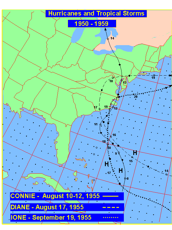
Figure 1. Tracks of 1955 Hurricanes over eastern North Carolina
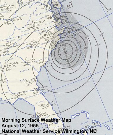
Figure 2. Surface Map of Hurricane Diane nearing Landfall.
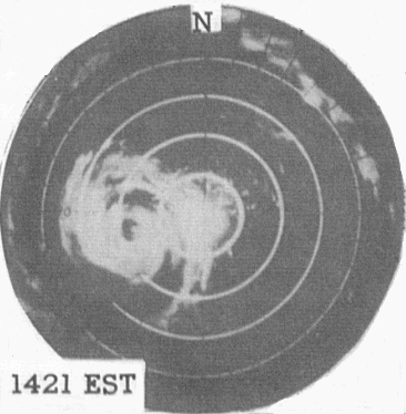
Figure 3. Radar depiction from Cape Hatteras Radar of Diane making landfall near Wilmington, August 12, 1955.
IMPACTS
Tides ran 6 to 8 feet above normal near Wilmington, and waves of up to 12 feet struck the southeast North Carolina coast. The resultant storm surge damaged beach houses, flooded coastal roads, and destroyed seawalls partially damaged by Hurricane Connie a few days earlier. Precipitation was most significant inland, peaking at 7.04 inches in New Bern (Figure 4). Rainfall from Hurricane Connie had saturated the ground and significantly raised water levels as it moved along the central North Carolina coast five days prior to the arrival of Hurricane Diane.
Nationally, although Connie did not produce significant flooding, it set the stage for Hurricane Diane to create some of the most destructive floods the river valleys of eastern Pennsylvania, northwest New Jersey, southeast New York and southern New England had ever seen. Rainfall amounted to 20 inches in New England over the two-day period when Diane was a tropical storm off the Northeast coast. The state of Connecticut received the most rainfall, especially in areas north and west of Hartford, with up to 12 inches of rainfall in 24 hours. As a result, losses from Hurricane Diane were greatest in Connecticut (Figure 5), where damages amounted to $350 million (1955 USD) in Connecticut alone and 77 lives were lost. The city of Woonsocket, Rhode Island was heavily damaged as a dam broke to the north west of the city, pushing a 20 foot wall of water down the Blackstone River.
Overall, between 180 and 200 total fatalities were estimated to be a result of Hurricane Diane. Although it was difficult to estimate total damages stemming from Hurricane Diane, it was determined that the floods and other impacts from the hurricane caused between $832 million and $1 billion (1955 USD) in damage, making it the costliest hurricane in U.S. history at the time (until it was surpassed by Hurricane Betsy in 1965).
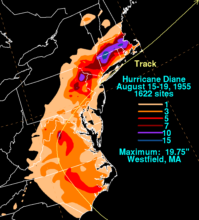
Figure 4. Rainfall totals from Hurricane (Courtesy David Roth, Weather Prediction Center)

Figure 5. New England flooding from Diane, August 1955.
SOURCES
National Hurricane Center
Monthly Weather Review
Weather Prediction Center


.png) Surf Forecast/Rip Currents
Surf Forecast/Rip Currents Map View
 Weather Hazard Briefing (when applicable)
 Forecaster Discussion
 Marine
 Text Products
.png) Skywarn
Skywarn Submit Storm Reports
 Coastal Flood
 Follow us on YouTube