
Huff Drive off Western Boulevard in Jacksonville. (11/12/2020). Credit WITN-TV.
Heavy rain fell across much of North Carolina on Wednesday November 11th through late into the night of Thursday November 12th. The rain was caused by a combination of a slow moving cold front along with a moist flow of air ahead of Tropical Storm Eta. As this moist flow combined with the cold front, very heavy rain began on Wednesday the 11th especially across Central North Carolina or mainly northwest of our forecast area. With rainfall amounts of more than 6", these heavier rainfall amounts upstream of our major rivers would eventually help to lead to rising water levels in our area.
Gradually as the cold front mentioned above slid south, heavier rain move into and through our area. Storm total rainfall amounts of 3" to 6" were common, with more than 6" falling near areas such as Snow Hill, Kinston and northern Duplin County. Although the rain was steady for quite some time, torrential rain fell with the passage of the front Thursday, which led to numerous reports of flash flooding in our area. In addition to the heavy rain, in the heavier showers it was quite breezy with winds of 30 to 40 MPH quite common. In exposed areas near or over the water the wind was much stronger, with Alligator River Bridge gusting to 74 MPH Thursday afternoon.
Widespread rain led to minor flooding on some of our smaller creeks, with moderate to near major flooding on the larger creeks and mainstem rivers. Minor river flooding occurred as early as Friday morning the 13th, with the larger rivers not cresting until Sunday the 15th to early the following week (16th - 18th). Some of the larger rivers that take awhile to crest such as the Neuse at Kinston did not crest until late the following week (20th) and remained high the following weekend, more than a week later.
Using the tabs below scroll through for more information and graphics.
Heavy Rain
The image below shows that most of Eastern North Carolina saw between 3" and 6" of rain. Much less fell over portions of the Outer Banks, with more than 6" over the western half of our area. Scroll down for an image of the rainfall along with some of the individual text reports. Be sure to click on the "MISC" tab to see some images of the total rainfall over much of North Carolina. Unfortunately some areas were hit much harder than us.

48 Hour Precipitation Reports (11/11/20 - 11/13/2020)
000 NOUS42 KMHX 131506 PNSMHX NCZ029-044>047-079>081-090>092-094-193>196-198-199-203>205-140306- Public Information Statement National Weather Service Newport/Morehead City NC 1006 AM EST Fri Nov 13 2020 ... STORM TOTAL PRECIPITATION REPORTS PAST 48 HOURS... Location Amount Time/Date Provider ...North Carolina... ...Beaufort County... Pcs Phosphat (COOP) 6.02 in 0800 AM 11/13 COOP Washington 1.0 SSW 5.45 in 0800 AM 11/13 COCORAHS Washington 3.1 ESE 5.34 in 0700 AM 11/13 COCORAHS Chocowinity 0.2 W 5.34 in 0800 AM 11/13 COCORAHS Belhaven 5.07 in 0932 AM 11/13 CWOP Bunyan RAWS 4.58 in 0813 AM 11/13 RAWS Bunyan 4.25 in 0813 AM 11/13 HADS ...Carteret County... Cedar Point 0.9 WSW 4.38 in 0453 AM 11/13 COCORAHS Cape Carteret 1.5 NE 4.36 in 0800 AM 11/13 COCORAHS Newport 10.3 SW 4.08 in 0800 AM 11/13 COCORAHS Cape Carteret 3.97 in 0930 AM 11/13 CWOP Cape Carteret 0.8 NE 3.97 in 0700 AM 11/13 COCORAHS Emerald Isle 0.2 ENE 3.82 in 0700 AM 11/13 COCORAHS Newport 3.75 in 0931 AM 11/13 CWOP Newport 3.60 in 0931 AM 11/13 CWOP Newport 5.6 SW 3.51 in 0630 AM 11/13 COCORAHS Newport 2.5 W 3.37 in 0700 AM 11/13 COCORAHS Newport 1.0 N 3.27 in 0700 AM 11/13 COCORAHS Emerald Isle 2.1 E 3.12 in 0700 AM 11/13 COCORAHS 0.2 SW Newport 3.06 in 0930 AM 11/13 CWOP Newport 2.96 in 1158 PM 11/12 COOP Newport 0.2 SW 2.91 in 0700 AM 11/13 COCORAHS Newport 1.7 SSE 2.73 in 0800 AM 11/13 COCORAHS Morehead City 2.70 in 0930 AM 11/13 CWOP Beaufort 15.1 N 2.69 in 0700 AM 11/13 COCORAHS Harkers Island 3.2 NE 2.56 in 0700 AM 11/13 COCORAHS Morehead City 1.4 NNW 2.52 in 0700 AM 11/13 COCORAHS Atlantic Beach 0.6 W 2.47 in 0732 AM 11/13 COCORAHS Beaufort 5.3 N 2.42 in 0700 AM 11/13 COCORAHS Pine Knoll Shores 1.4 E 2.37 in 0700 AM 11/13 COCORAHS Beaufort 1.4 N 2.34 in 0800 AM 11/13 COCORAHS Beaufort 6.3 NNW 2.34 in 0700 AM 11/13 COCORAHS Morehead City 0.6 NW 2.31 in 0700 AM 11/13 COCORAHS Beaufort 2.27 in 0937 AM 11/13 CWOP Beaufort 3.8 N 2.27 in 0700 AM 11/13 COCORAHS Newport 2.23 in 0930 AM 11/13 CWOP Cedar Island 0.6 SSE 2.19 in 0700 AM 11/13 COCORAHS Beaufort (MRH ASOS) 2.17 in 0858 AM 11/13 ASOS Atlantic Beach 2.16 in 0931 AM 11/13 CWOP Beaufort 0.5 W 2.10 in 0800 AM 11/13 COCORAHS Beaufort 1.5 NNW 2.08 in 0645 AM 11/13 COCORAHS Cedar Island RAWS 2.05 in 0925 AM 11/13 RAWS 7 W Cedar Island 2.02 in 0904 AM 11/13 AWOS Cedar Island RAWS 2.01 in 0825 AM 11/13 HADS Morehead City 6.0 WNW 1.86 in 0700 AM 11/13 COCORAHS Indian Beach 1.71 in 0930 AM 11/13 CWOP Croatan RAWS 1.62 in 0905 AM 11/13 RAWS Cedar Island 0.3 SSE 1.26 in 0643 AM 11/13 COCORAHS ...Craven County... New Bern 2.6 SW 7.20 in 0700 AM 11/13 COCORAHS New Bern 1.3 NNE 7.01 in 0700 AM 11/13 COCORAHS River Bend 0.8 ENE 6.98 in 0700 AM 11/13 COCORAHS New Bern 4.9 SW 6.91 in 0700 AM 11/13 COCORAHS New Bern 5.3 SW 6.84 in 0645 AM 11/13 COCORAHS New Bern 4.6 SW 6.80 in 0800 AM 11/13 COCORAHS New Bern 1.4 WSW 6.69 in 0800 AM 11/13 COCORAHS New Bern RAWS 6.48 in 0817 AM 11/13 RAWS Trent Woods 0.9 WNW 6.48 in 0700 AM 11/13 COCORAHS James City 2.5 S 6.19 in 0700 AM 11/13 COCORAHS 1 SSW James City 5.94 in 0935 AM 11/13 AWS Trent Woods 1.2 ENE 5.72 in 0600 AM 11/13 COCORAHS New Bern 7.3 ESE 5.35 in 0640 AM 11/13 COCORAHS New Bern 7.5 ESE 5.24 in 0700 AM 11/13 COCORAHS Trent Woods 1.3 SSE 5.21 in 0700 AM 11/13 COCORAHS Perrytown (COOP) 5.21 in 0800 AM 11/13 COOP Trent Woods 1.0 NNE 5.12 in 0635 AM 11/13 COCORAHS New Bern 3.8 S 5.05 in 0800 AM 11/13 COCORAHS New Bern 4.2 S 5.03 in 0700 AM 11/13 COCORAHS New Bern 5.2 SE 4.83 in 0650 AM 11/13 COCORAHS New Bern 8.8 W 4.70 in 0700 AM 11/13 COCORAHS New Bern (EWN ASOS) 4.45 in 0854 AM 11/13 ASOS Geneseo 4.21 in 0930 AM 11/13 CWOP 3 S Havelock 3.83 in 0935 AM 11/13 AWS Havelock 3.75 in 0935 AM 11/13 CWOP 3.6 E Jasper 2.65 in 0900 AM 11/13 HADS ...Dare County... Dare Bomb Range RAWS 3.41 in 0928 AM 11/13 RAWS Kill Devil Hills 3.34 in 0938 AM 11/13 CWOP Kill Devil Hills 2.2 NNW 2.94 in 0645 AM 11/13 COCORAHS Manteo 1.3 E 2.57 in 0800 AM 11/13 COCORAHS Dare Co Gnry Ran (2DP AWOS) 2.46 in 0856 AM 11/13 AWOS Nags Head 2.44 in 0935 AM 11/13 AWS Nags Head 2.01 in 0939 AM 11/13 CWOP Manteo (MQI AWOS) 1.80 in 0935 AM 11/13 AWOS Frisco (HSE ASOS) 1.10 in 0851 AM 11/13 ASOS Rodanthe 1.0 SSE 0.88 in 0700 AM 11/13 COCORAHS Buxton 0.62 in 0930 AM 11/13 CWOP ...Duplin County... Albertson 1.2 WNW 7.25 in 0600 AM 11/13 COCORAHS Mount Olive 2.4 SW 7.15 in 0700 AM 11/13 COCORAHS Rose Hill 0.1 NNW 6.70 in 0700 AM 11/13 COCORAHS Beautancus 3.0 ENE 6.12 in 0700 AM 11/13 TRAINED SPOTTER Warsaw 5.53 in 0230 AM 11/13 CWOP Wallace 6.2 ENE 4.71 in 0629 AM 11/13 COCORAHS ...Greene County... Snow Hill 3.1 NNE 7.80 in 0800 AM 11/13 COCORAHS ...Hyde County... Fairfield RAWS 3.47 in 0817 AM 11/13 RAWS Swanquarter 0.4 NNE 2.88 in 0700 AM 11/13 COCORAHS Engelhard 0.8 NW 2.50 in 0700 AM 11/13 COCORAHS Ocracoke Lighthouse 1.34 in 0900 AM 11/13 HADS ...Jones County... Trenton 4.67 in 0840 AM 11/13 HADS ...Lenoir County... Kinston 4.4 WNW 6.13 in 0700 AM 11/13 COCORAHS Kinston 7.0 SW 6.11 in 0700 AM 11/13 COCORAHS Seven Springs 5.44 in 0930 AM 11/13 CWOP Kinston 5.1 WNW 5.35 in 0700 AM 11/13 COCORAHS ...Martin County... Robersonville 0.0 NNW 5.50 in 0700 AM 11/13 COCORAHS Williamston 8.9 SSE 4.33 in 0620 AM 11/13 COCORAHS Jamesville 6.1 SW 3.63 in 0700 AM 11/13 COCORAHS ...Onslow County... Half Moon 3.0 SSW 6.91 in 0800 AM 11/13 SPOTTER Jacksonville 5.7 WSW 6.49 in 0700 AM 11/13 COCORAHS Hoffman RAWS 6.35 in 0810 AM 11/13 RAWS Sneads Ferry 1.2 SSW 6.19 in 0600 AM 11/13 COCORAHS Jacksonville 3.3 W 6.18 in 0800 AM 11/13 COCORAHS Sneads Ferry 6.17 in 0930 AM 11/13 CWOP Jacksonville 7.0 W 6.17 in 0931 AM 11/13 CWOP Holly Ridge 4.9 ENE 6.05 in 0700 AM 11/13 COCORAHS Camp Lejeune 1.4 NW 5.84 in 0700 AM 11/13 COCORAHS Jacksonville 1.2 NE 5.84 in 0700 AM 11/13 COCORAHS Holly Ridge 5.64 in 0940 AM 11/13 CWOP Jacksonville 5.60 in 0936 AM 11/13 CWOP Jacksonville 6.8 NW 5.52 in 0700 AM 11/13 COCORAHS Jacksonville 4.5 NW 5.50 in 0700 AM 11/13 COCORAHS Richlands 2.8 NW 5.47 in 0800 AM 11/13 COCORAHS Jacksonville 5.33 in 0939 AM 11/13 CWOP Sandy Run RAWS 4.88 in 0819 AM 11/13 RAWS Jacksonville (NCA ASOS) 4.81 in 0856 AM 11/13 AWOS Swansboro 3.3 NW 4.31 in 0700 AM 11/13 COCORAHS Hubert 4.9 SE 4.25 in 0609 AM 11/13 COCORAHS Richlands (OAJ AWOS) 3.84 in 0856 AM 11/13 AWOS ...Pamlico County... Bayboro 4.36 in 0935 AM 11/13 AWS Grantsboro 4.6 SSW 3.85 in 0803 AM 11/13 COCORAHS Merritt 1.5 WSW 3.34 in 0600 AM 11/13 COCORAHS Lowland 0.2 SE 3.29 in 0700 AM 11/13 COCORAHS Oriental 4.3 NNW 3.28 in 0700 AM 11/13 COCORAHS 0.8 SW Oriental 2.81 in 0900 AM 11/13 HADS Oriental 2.67 in 0938 AM 11/13 CWOP ...Pitt County... Greenville 5.7 NW 6.88 in 0700 AM 11/13 COCORAHS 2.5 W Pitt-Greenville Airpor 5.82 in 0815 AM 11/13 HADS Greenville 4.7 WNW 5.78 in 0650 AM 11/13 COCORAHS Fountain 0.1 NE 5.37 in 0700 AM 11/13 COCORAHS Greenville (COOP) 5.18 in 1158 PM 11/12 COOP Winterville 4.3 ESE 4.41 in 0700 AM 11/13 COCORAHS Greenville 4.3 SSE 4.38 in 0800 AM 11/13 COCORAHS Greenville 4.4 SSE 4.37 in 0800 AM 11/13 COCORAHS Winterville 2.8 WNW 4.33 in 0700 AM 11/13 COCORAHS Greenville 7.1 SSE 4.31 in 0700 AM 11/13 COCORAHS Greenville 2.8 ESE 4.20 in 0830 AM 11/13 COCORAHS Greenville 4.18 in 0930 AM 11/13 CWOP Winterville 1.0 ENE 4.16 in 0700 AM 11/13 COCORAHS Greenville 2.0 SE 4.07 in 0800 AM 11/13 COCORAHS Winterville 2.6 ENE 4.07 in 0730 AM 11/13 COCORAHS Greenville 1.4 SE 3.96 in 0700 AM 11/13 COCORAHS Winterville 3.5 W 3.89 in 0700 AM 11/13 COCORAHS ...Tyrrell County... Columbia 5.87 in 0900 AM 11/13 HADS Gum Neck (COOP) 4.31 in 0600 AM 11/13 COOP ...Washington County... Pocosin Lakes RAWS 5.26 in 0817 AM 11/13 RAWS Creswell 2.98 in 0930 AM 11/13 CWOP ...Maritime Stations... 1.9 SW Jacksonville 5.22 in 0740 AM 11/13 HADS Southern Shores 2.67 in 0937 AM 11/13 CWOP Oriental 1.58 in 0935 AM 11/13 CWOP Frisco 3.3 NE 0.86 in 0700 AM 11/13 COCORAHS && && |
River Flooding
As we mentioned above heavy rain upstream of our area and then eventually over our area caused widespread flooding especially on our larger creeks and streams. Below are some graphs of both the river levels and forecasts that captured the height of the cresting rivers. Use the dates on the bottom of the graphs for reference.

The image above is the river level (in blue) and forecast (in purple) of the Neuse River at Kinston. Notice how the crest
was a full WEEK after the heavy rain or on November 20th, 2020.

The image above is the river level (in blue) and forecast (in purple) of the Tar River at Greenville showing the crest of just under 20 feet on November 17th.

The image above is the river level (in blue) and forecast (in purple) of the Contentnea Creek at Hookerton showing the crest in major flood stage around midnight on the 16th.

The image above is the river level (in blue) and forecast (in purple) of the N.E Cape Fear River near Chinquapin showing the crest.
Strong Winds
Wind gusts between 30 and 40 MPH were common with the heavier rain Thursday the 12th. In some areas that were close to water or had a marine exposure, the gusts were quite higher. Scroll down for a list of the highest observations.
Wind Reports (11/12/2020)
000
NOUS42 KMHX 122227
PNSMHX
NCZ029-044>047-079>081-090>092-094-193>196-198-199-203>205-131027-

Public Information Statement
National Weather Service Newport/Morehead City NC
527 PM EST Thu Nov 12 2020

...HIGHEST WIND REPORTS OVER THE LAST 24 HOURS...

Location                     Speed     Time/Date       Provider

...North Carolina...

...Beaufort County...
Washington (OCW AWOS)        41 MPH    1155 AM 11/12   AWOS
Bunyan RAWS                  27 MPH    1213 PM 11/12   RAWS

...Carteret County...
7 W Cedar Island             51 MPH    0205 PM 11/12   AWOS
Beaufort (MRH ASOS)          46 MPH    0217 PM 11/12   ASOS
Morehead City                42 MPH    0200 PM 11/12   CWOP
Cape Lookout                 38 MPH    0300 PM 11/12   NDBC
Bogue Field (NJM ASOS)       37 MPH    0143 PM 11/12   AWOS
Atlantic Beach               35 MPH    0216 PM 11/12   CWOP
Newport                      32 MPH    0154 PM 11/12   CWOP
7 W Cedar Island             32 MPH    1255 PM 11/12   AWOS
Cedar Island RAWS            31 MPH    0325 PM 11/12   RAWS
Newport                      30 MPH    0146 PM 11/12   CWOP
Indian Beach                 26 MPH    1100 AM 11/12   CWOP
Cape Lookout                 26 MPH    1100 AM 11/12   NDBC
Croatan RAWS                 25 MPH    0305 PM 11/12   RAWS
Newport                      25 MPH    1100 AM 11/12   CWOP

...Craven County...
Cherry Point (NKT ASOS)      49 MPH    0136 PM 11/12   AWOS
Havelock                     38 MPH    0131 PM 11/12   CWOP
New Bern (EWN ASOS)          35 MPH    1250 PM 11/12   ASOS
New Bern RAWS                26 MPH    0117 PM 11/12   RAWS

...Dare County...
Rodanthe                     45 MPH    0243 PM 11/12   CWOP
Dare Co Gnry Ran (2DP AWOS)  43 MPH    0130 PM 11/12   AWOS
Dare Bomb Range RAWS         39 MPH    0228 PM 11/12   RAWS
Manteo (MQI AWOS)            38 MPH    0135 PM 11/12   AWOS
Frisco                       37 MPH    0231 PM 11/12   CWOP
Nags Head                    31 MPH    0208 PM 11/12   CWOP
Frisco (HSE ASOS)            31 MPH    0128 PM 11/12   ASOS
Buxton                       30 MPH    0246 PM 11/12   CWOP
Kill Devil Hills (FFA AWOS)  29 MPH    0155 PM 11/12   AWOS
Nags Head                    28 MPH    1008 AM 11/12   CWOP
Kill Devil Hills             27 MPH    0131 PM 11/12   CWOP

...Hyde County...
4 NE Engelhard               44 MPH    0135 PM 11/12   AWOS

...Lenoir County...
Kinston (ISO AWOS)           32 MPH    1124 AM 11/12   AWOS

...Onslow County...
Jacksonville (NCA ASOS)      43 MPH    0116 PM 11/12   AWOS
Sneads Ferry                 37 MPH    0146 PM 11/12   CWOP
Richlands (OAJ AWOS)         32 MPH    1122 PM 11/11   AWOS
Hoffman RAWS                 25 MPH    0210 PM 11/12   RAWS

...Pamlico County...
Oriental                     32 MPH    0157 PM 11/12   CWOP

...Washington County...
Roper                        28 MPH    1016 AM 11/12   CWOP

...Maritime Stations...
Diamond Shoals Buoy          58 MPH    0320 PM 11/12   NDBC
Duck Pier                    49 MPH    0106 PM 11/12   NOS-NWLON
31 S Bogue Inlet Pier        43 MPH    0308 PM 11/12   NDBC
Beaufort                     40 MPH    0212 PM 11/12   NOS-NWLON
Southern Shores              38 MPH    0110 PM 11/12   CWOP
Oregon Inlet Marina          37 MPH    0212 PM 11/12   NOS-NWLON

&&


0202 PM     MARINE TSTM WIND OREGON INLET            35.80N 75.56W
11/12/2020  M43 MPH          DARE               NC   MESONET

            WXFLOW SITE AT OREGON INLET REPORTED A 37
            KNOT (43 MPH) MARINE THUNDERSTORM WIND GUST.

0210 PM     MARINE TSTM WIND FORT MACON              34.70N 76.69W
11/12/2020  M54 MPH          CARTERET           NC   MESONET

            WXFLOW SITE IN FORT MACON OBSERVED A 47 KNOT
            (54 MPH) MARINE THUNDERSTORM WIND GUST.

0315 PM     MARINE TSTM WIND DIAMOND SHOALS          35.01N 75.40W
11/12/2020  M58 MPH          AMZ154             NC   BUOY

            NDBC BUOY AT DIAMOND SHOALS REPORTED A 51
            KNOT (58 MPH) MARINE THUNDERSTORM WIND GUST.

0100 PM     MARINE TSTM WIND ALLIGATOR RIVER BRIDGE  35.90N 76.01W
11/12/2020  M74 MPH          AMZ131             NC   PUBLIC

            WXFLOW SITE ON THE ALLIGATOR RIVER BRIDGE
            OBSERVED A 64 KNOT (74 MPH) MARINE
            THUNDERSTORM WIND GUST.

0201 PM     MARINE TSTM WIND NORTH CENTRAL PAMLICO S 35.42N 75.83W
11/12/2020  M56 MPH          AMZ135             NC   MESONET

            WXFLOW SITE IN THE NORTH CENTRAL PAMLICO
            SOUND REPORTED A 49 KNOT (56 MPH) MARINE
            THUNDERSTORM WIND GUST.

0141 PM     MARINE TSTM WIND 2 W NAGS HEAD           35.94N 75.66W
11/12/2020  M45 MPH          AMZ231             NC   MESONET

            WXFLOW SITE IN THE NORTHERN ROANOKE SOUND
            OBSERVED A 39 KNOT (45 MPH) MARINE
            THUNDERSTORM WIND GUST.


&&


&&
&&
|
Cape Carteret Heavy Rain/Wind November 12th, 2020
Pictures
Flooding Pictures November 12th, 2020 (flash flooding and small creeks)
|
Jacksonville, NC (Blue Creek) Credit: Greg DiCarlo |

Greenville, NC (Evans Street and Arlington Blvd.) Credit: WITN-TV |

Farmville, NC Credit: NCDOT. |
|
Jacksonville, NC (Pony Farm Road Area of 1313) Credit: Onslow County EMA |
.jpg)
Jacksonville, NC (Pony Farm Road Area of 2053) Credit: Onslow County EMA |
.jpg)
Jacksonville, NC (Old Maplehurst Area of 1300) Credit: Onslow County EMA |
|
Jacksonville, NC (Walnut Drive (off Firetower)) Credit: Onslow County EMA |
.jpg)
Jacksonville, NC (Greystone Ave. (off Pony Farm)) Credit: Onslow County EMA |
.jpg)
Jacksonville, NC (Vandergrift Drive (off Maplehurst)) Credit: Onslow County EMA |
|
Jacksonville, NC (Holly Shelter Road (Area of 660)) Credit: Onslow County EMA |

Jacksonville, NC (McDaniel Drive) Credit: Onslow County EMA |
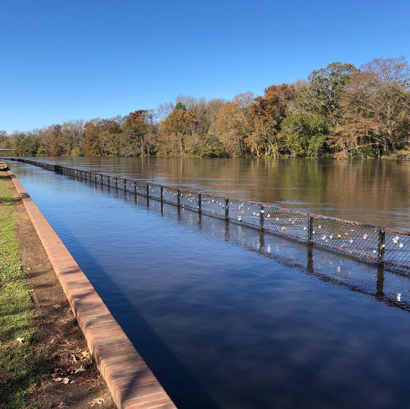
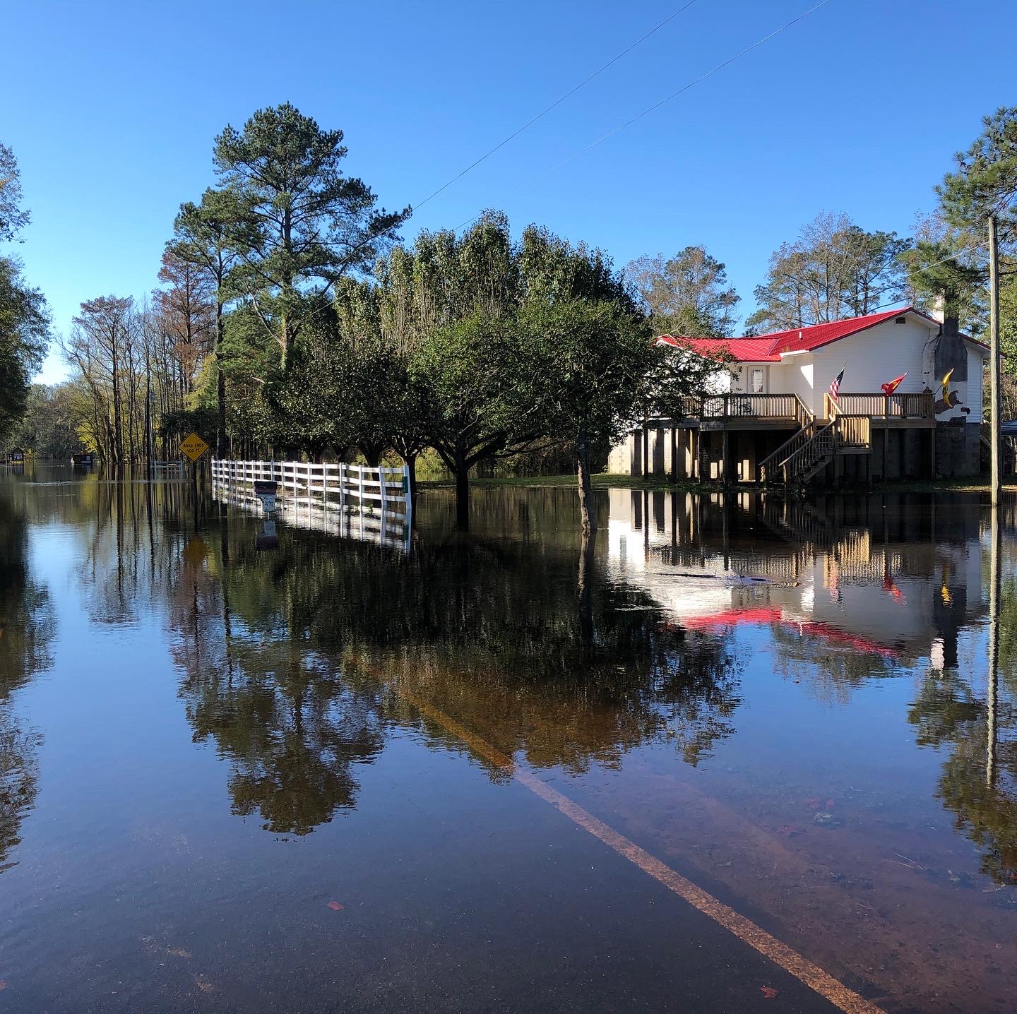
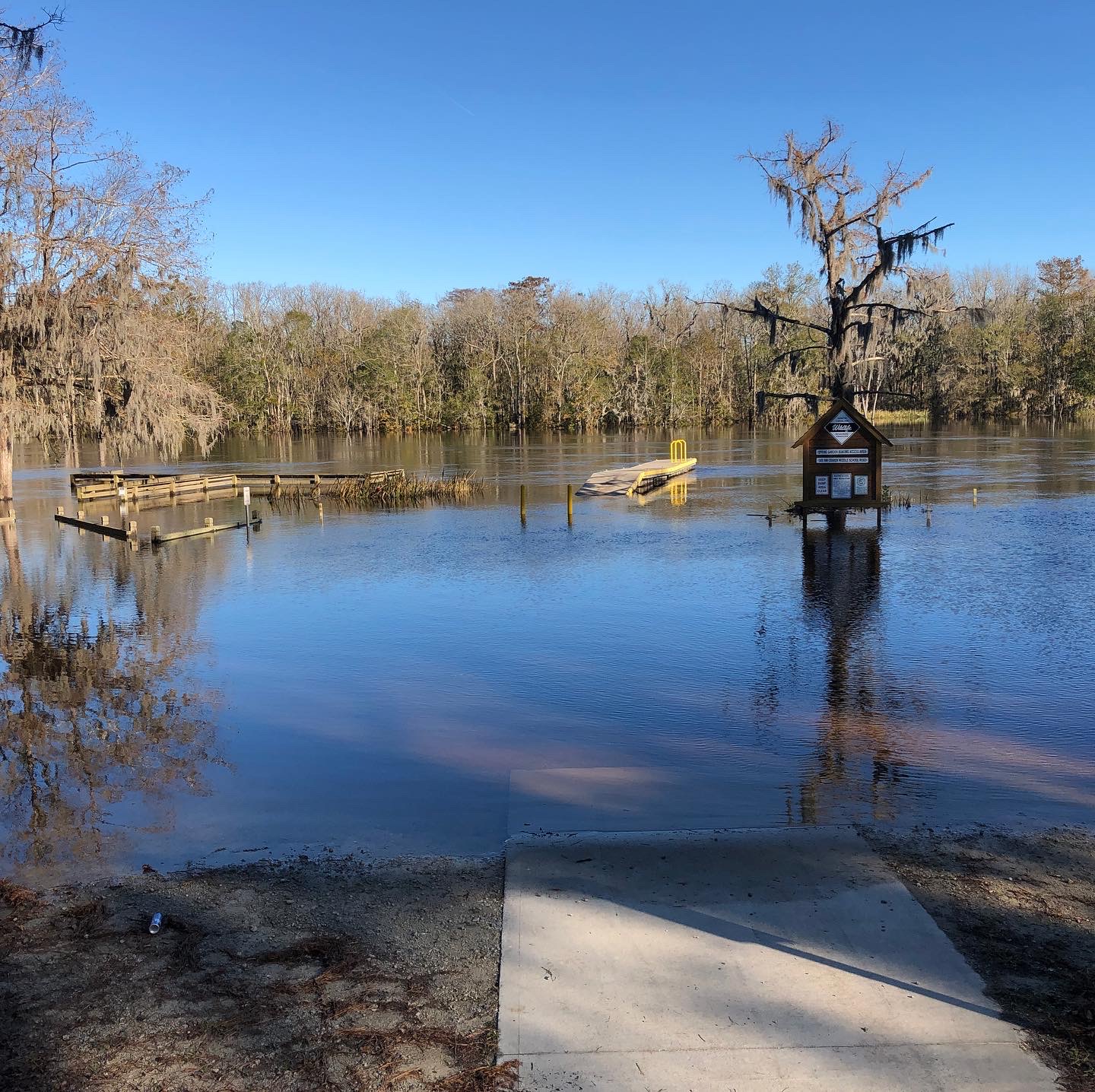
Flooding Pictures November 19th, 2020 (larger rivers/longer term flooding)
|
Credit: NWS Flood Survey |
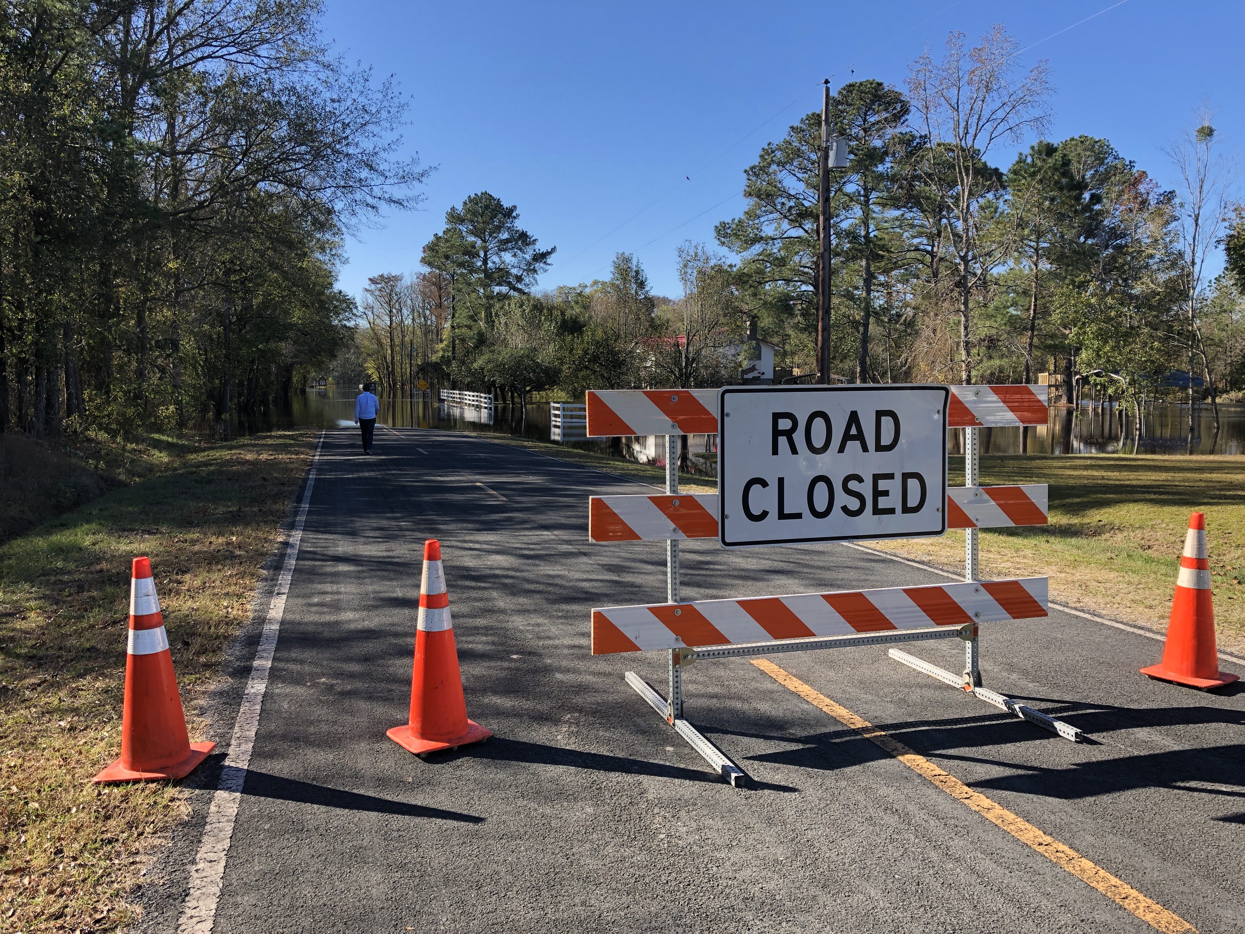
Credit: NWS Flood Survey |

Credit: NWS Flood Survey |
|
Credit: NWS Flood Survey |
Credit: NWS Flood Survey |
Credit: NWS Flood Survey |
Videos
National Weather Service Office (Newport, NC) Heavy Rain/Wind November 12th, 2020
Misc
The images below show that heavy rain fell across much of North Carolina into southern Virginia. While the heaviest rain was initially across the Central and Western part of the state Wednesday (first image), the heavier rain shifted east by Thursday (second image).
November 12th, 2020 1-Day Rainfall Observed

November 13th, 2020 1-Day Rainfall Observed
.png)


.jpg)
.jpg)
.jpg)

.png) Surf Forecast/Rip Currents
Surf Forecast/Rip Currents Map View
 Weather Hazard Briefing (when applicable)
 Forecaster Discussion
 Marine
 Text Products
.png) Skywarn
Skywarn Submit Storm Reports
 Coastal Flood
 Follow us on YouTube