Please join us in promoting severe weather safety during this year's "Severe Weather Preparedness Week". The National Weather Service asks emergency management, public safety officials, local media and Weather-Ready Nation Ambassadors to help join forces in improving the nation's readiness, responsiveness, and overall resilience against severe weather during the upcoming season.
Each day this week, a different topic will be covered. Remember that preparedness is something we do all year long!
Sunday
Severe Weather Preparedness Week Overview
Statewide Tornado Drill scheduled for Wednesday, March 9th at 9:30 AM
This week is North Carolina’s annual Severe Weather Preparedness Week. This week the National Weather Service and the North Carolina Department of Public Safety are teaming up to bring this severe weather safety campaign to all of North Carolina’s residents. With warmer weather quickly approaching, now is the time to prepare for the severe weather season. If each North Carolina resident would take a few moments this week to learn about severe weather safety and implement a safety plan, then we would all be better off when severe thunderstorms and tornadoes inevitably strike our state and the likelihood of injury and fatalities caused by severe weather could be minimized.
Severe weather and severe weather preparedness takes many forms, so each day this week we will highlight a different preparedness topic. This week’s topics will include…
| Day of The Week | Topics |
|---|---|
| Sunday | Overview of the week |
| Monday | Severe thunderstorms and tornadoes |
| Tuesday | Ways to receive severe weather alerts, and information about the Statewide Tornado Drill |
| Wednesday | Staying safe when high winds, hail, and tornadoes strike |
| Thursday | Lightning safety |
| Friday | Flash flood safety |
| Saturday | Make a plan and encourage others to do the same |
On Wednesday, March 9th at 9:30 AM, the National Weather Service in cooperation with local broadcasters will conduct a statewide tornado drill. The alarm test, which will come in the form of a Required Monthly Test, will activate the State Emergency Alert System and be carried by local radio broadcasters. Every school, business, and residence is encouraged to participate in this drill. It’s really easy: at 9:30 AM on Wednesday, take a few moments to practice your severe weather safety plan, and seek shelter for a few minutes as if a tornado was headed your way. Practicing this when the weather is good will allow you to react more quickly when the weather turns bad.
Please visit the North Carolina Department of Public Safety’s preparedness website readync.org. On this web page you will find an abundance of information, and links to a free cell phone app, that will help you plan and prepare for the severe weather season.
Monday
Severe Thunderstorms and Tornadoes
A thunderstorm is a local storm that produces lightning and thunder. Thunderstorms are often accompanied by showery rain and gusty winds, and may also bring hail or snow. Thunderstorms occur most frequently during the spring and summer, but they are also possible in the fall and winter. North Carolina experiences about 40 to 50 thunderstorm days per year. About 10 percent of thunderstorms are classified as severe – one that produces hail at least an inch in diameter, has winds of 58 miles per hour or stronger, or produces a tornado.
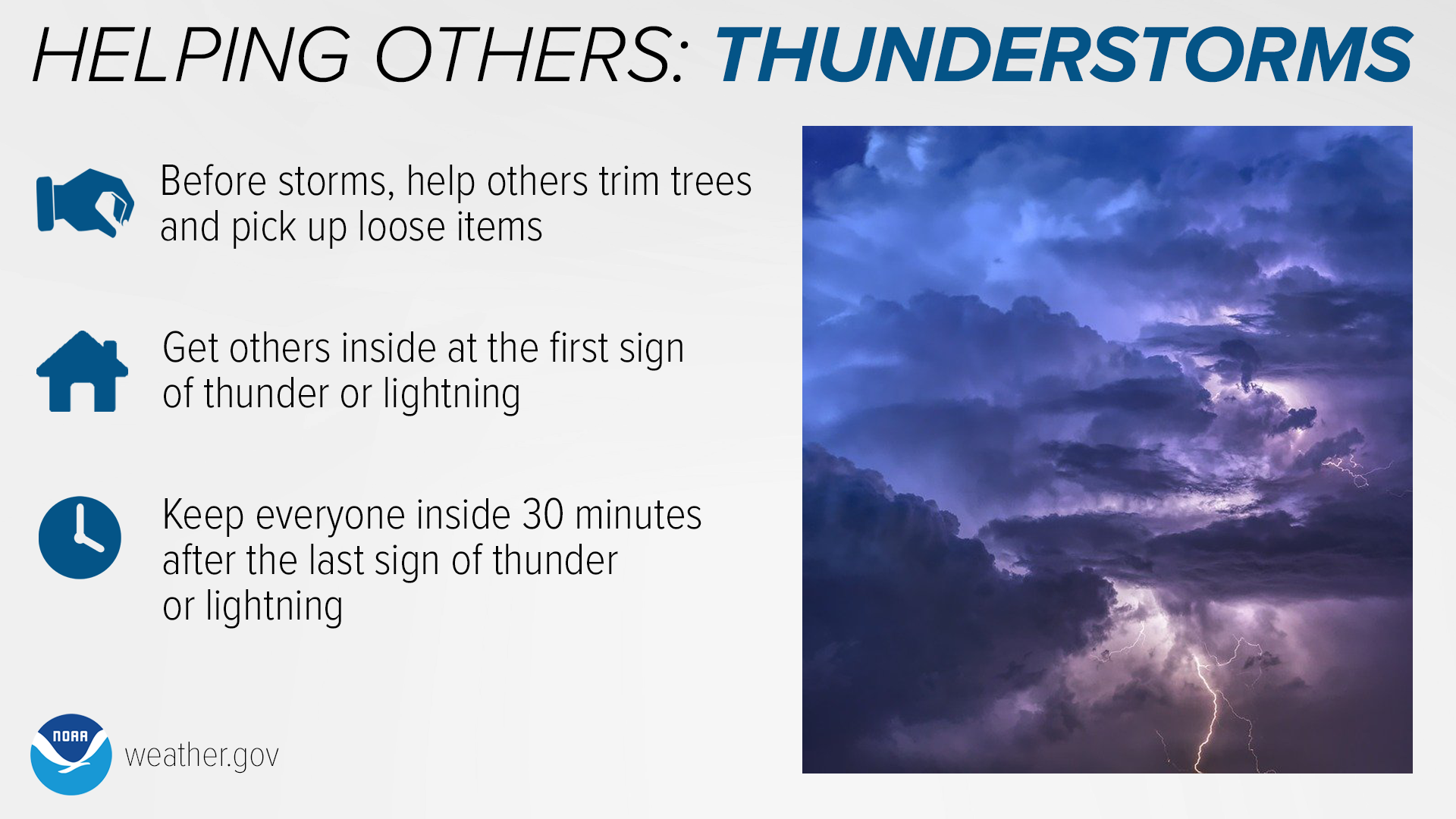
Thunderstorms are sometimes underestimated as a serious weather threat, but they can be deadly. Strong winds can turn tree branches and ordinary loose objects into dangerous projectiles — help your community stay safe by trimming trees and picking up loose items.
Lightning can strike up to 10 miles away from a storm. Make sure to get everyone inside at the first sign of thunder or lightning, and keep them inside until at least 30 minutes after the last sign of thunder or lightning.
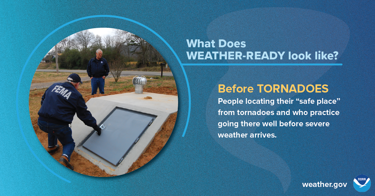
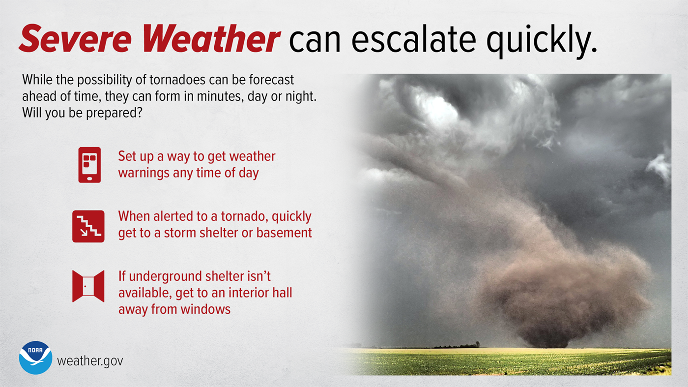
Tornadoes are nature’s most violent storms. Spawned from powerful thunderstorms, tornadoes can cause fatalities and devastate a neighborhood in seconds. A tornado appears as a rotating, funnel-shaped cloud that extends from a thunderstorm to the ground with whirling winds that can reach 300 miles per hour. Damage paths can be in excess of one mile wide and 50 miles long. Some tornadoes are clearly visible, while rain or nearby low-hanging clouds obscure others. Sometimes, tornadoes develop so rapidly that little, if any, advance warning is possible.
Severe Thunderstorms and Tornadoes Infographics
(click to enlarge)
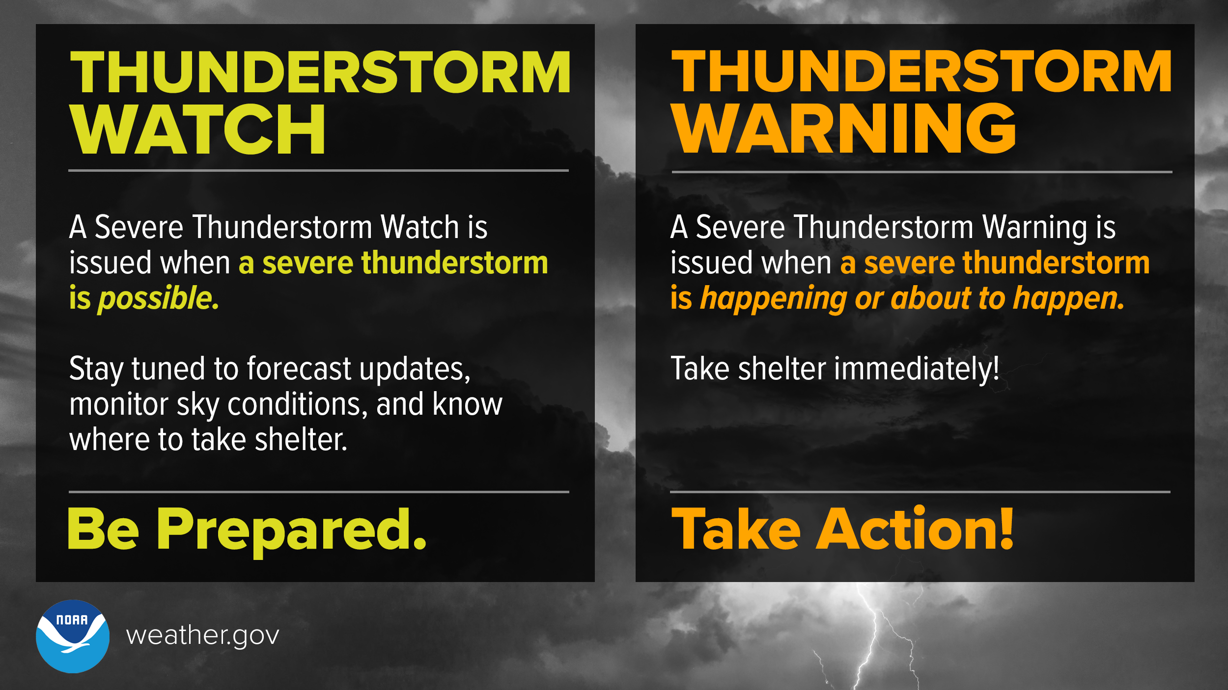
A Severe Thunderstorm WATCH means Be Prepared. Stay informed and be ready to act, because severe thunderstorms are possible.
A Severe Thunderstorm WARNING means Take Action! Take shelter in a strong building, because severe weather is occurring or will occur shortly.
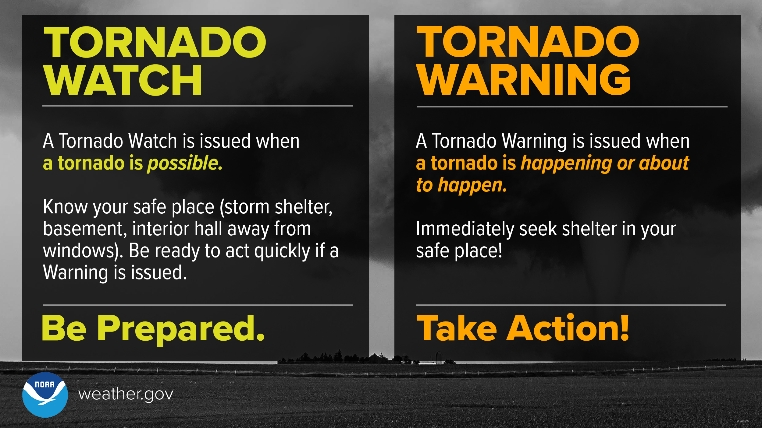
A Tornado WATCH means Be Prepared.
A Tornado WARNING means Take Action!
 |
 |
 |
 |
 |
 |
Did You Know Their Are Different Types of Tornadoes?

Tuesday
Receiving Severe Weather Alerts/Tornado Drill Information
***On Wednesday, March 9th at 9:30 AM, the National Weather Service will conduct a statewide tornado drill***
The alarm test, which will come in the form of a Required Monthly Test, will activate the State Emergency Alert System and be carried by local radio broadcasters. Every school, business, and residence is encouraged to participate in this drill. It’s really easy: at 9:30 AM on Wednesday, take a few moments to practice your severe weather safety plan, and seek shelter for a few minutes as if a tornado was headed your way.
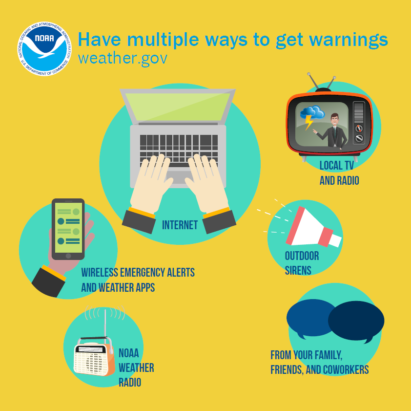
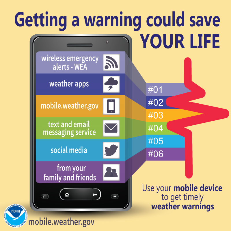
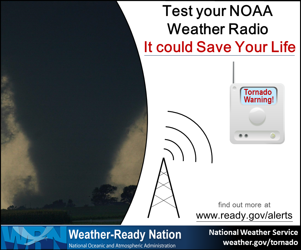
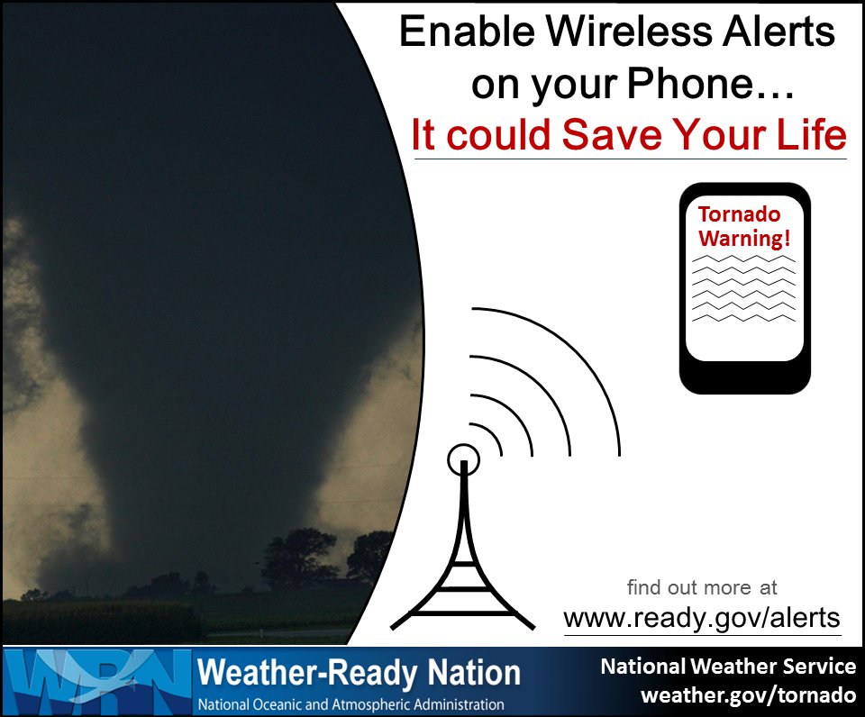
One of the keys to staying safe during the severe weather season is making sure that you have a way to receive lifesaving severe weather watches and warnings. There are many methods and tools, some of which are available with no cost or fees, that you can use to receive these important lifesaving alerts no matter where you are - at home, at school, or at work.
| Day of The Week | Topics |
|---|---|
| NOAA Weather Radio (NWR) | NWR is a nationwide network of radio stations broadcasting continuous weather information from the nearest National Weather Service office. Specially built receivers, which can be purchased at most electronics and large retail stores for less than $40, receive the NWR broadcast 24 hours a day, 7 days a week, and sound an audible alert when official watches and warnings are issued for your area. Think of these radios as a “smoke detector” for severe weather alerts. |
| Wireless Emergency Alerts (WEA) | With WEA, emergency alerts can be sent to your cell phone or mobile device when you may be in harm's way, without need to download an app or subscribe to a service. In addition to other alert types such as AMBER Alerts, this free service will transmit extreme weather warnings such as Tornado and Flash Flood warnings to your cell phone. The alerts will look like a text message, and will typically show the type and time of the alert, any action you should take. WEA messages include a special tone and vibration. If you receive a WEA message, you should follow any action advised by the emergency message. Seek more details from your favorite TV or radio station, NOAA Weather Radio, news website, desktop application, mobile application, or other trusted source of information. |
| Cell phone apps | There are many great cell phone apps that provide real-time NWS warnings and alerts, some of which are free to download and use, and others that may charge a small fee. A simple search of your app provider will reveal many of these apps. |
| Emergency Alert System (EAS) and your favorite TV and radio stations | EAS is the message dissemination pathway that sends warnings via broadcast, cable, satellite, and wireline services. EAS may be used by state and local authorities, including the National Weather Service, in cooperation with the broadcast community, to deliver important emergency information such as severe weather information, AMBER alerts, and local incident information targeted to specific areas. In short, when severe weather strikes, it’s a good idea to tune to your favorite local TV or radio station or web site for detailed information about the severe weather threat. |
In addition to the aforementioned alerting system, many communities also offer free emergency alert notifications through their own systems, such as reverse 911 phone systems. Be sure to check with your local emergency management agency to learn what is available in your area.
Receiving warnings for dangerous weather events can save your life. Luckily, there are many different ways to get life-saving warnings. Stay Weather-Ready by knowing your options:
Receiving Severe Weather Alerts Infographics
(click to enlarge)
WEA are emergency messages sent by authorized government alerting authorities through your mobile carrier. America’s wireless industry is helping to build a Weather-Ready Nation through this nationwide text emergency alert system. weather.gov/wrn/wea
 |
 |
 |
 |
Wednesday
High Winds/Hail/Tornadoes
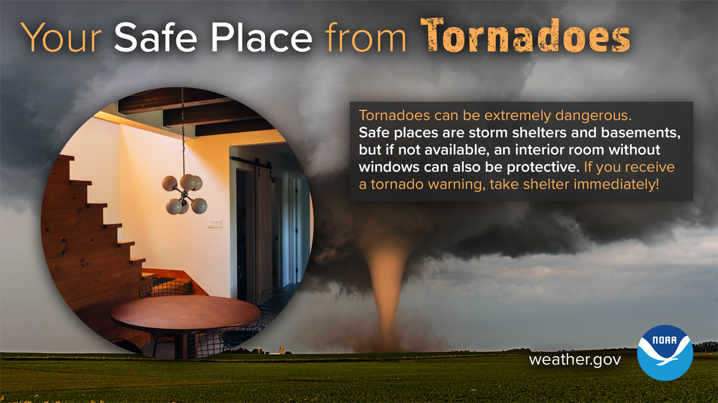
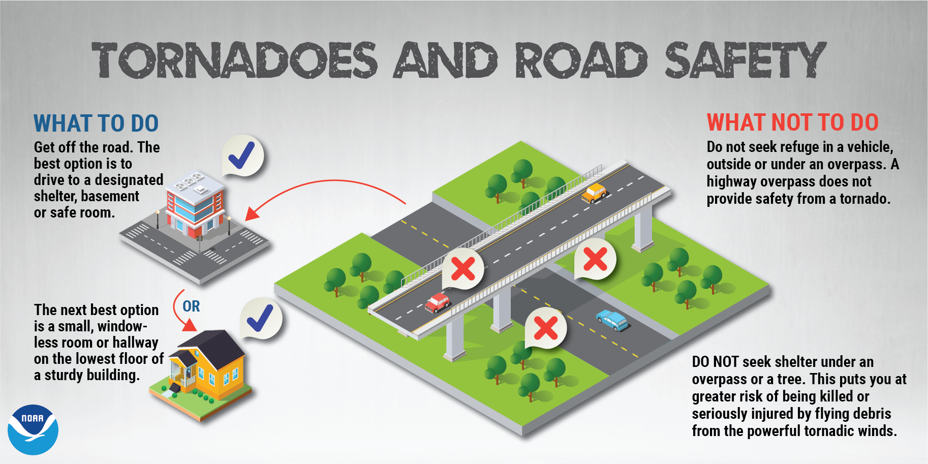
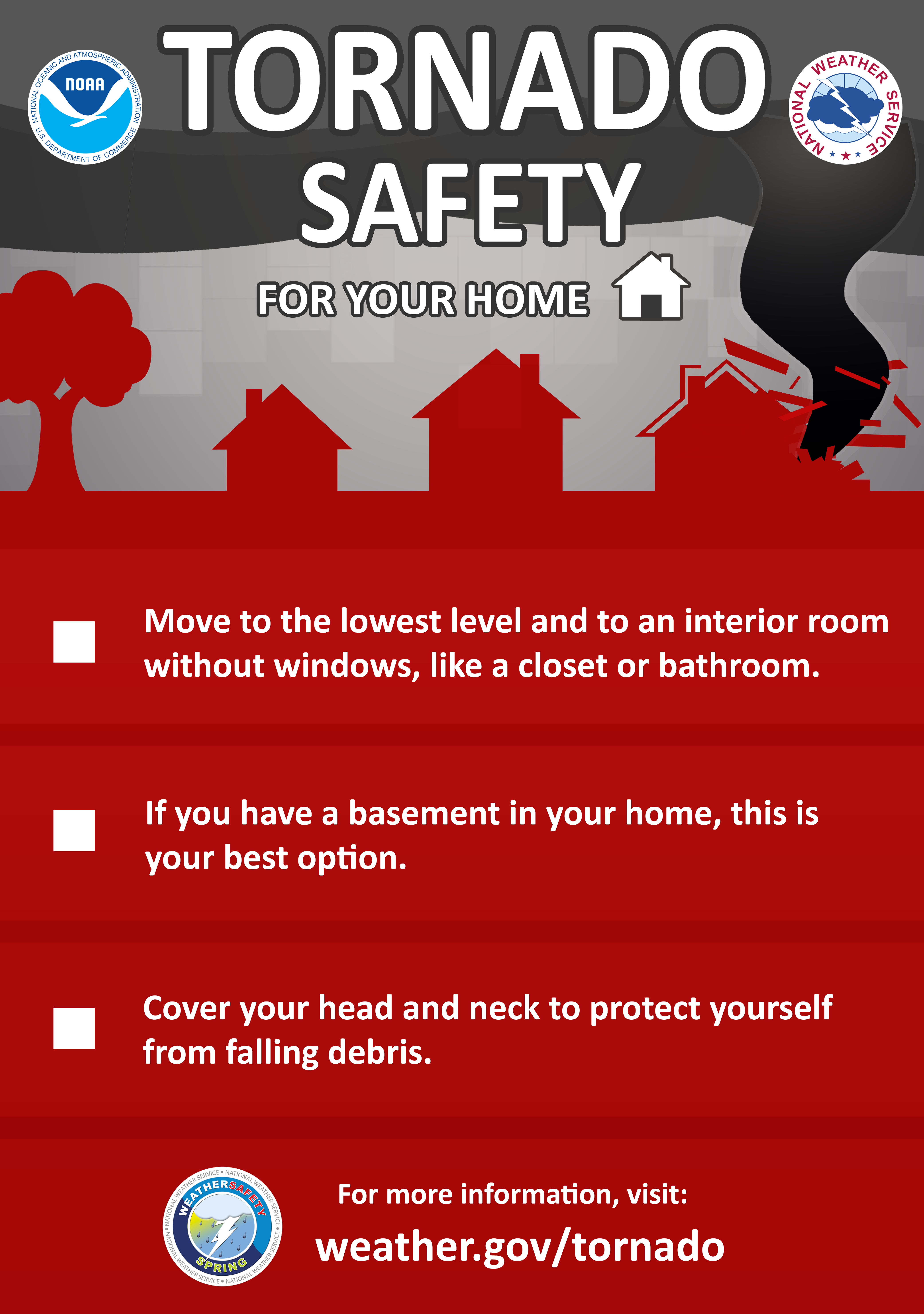
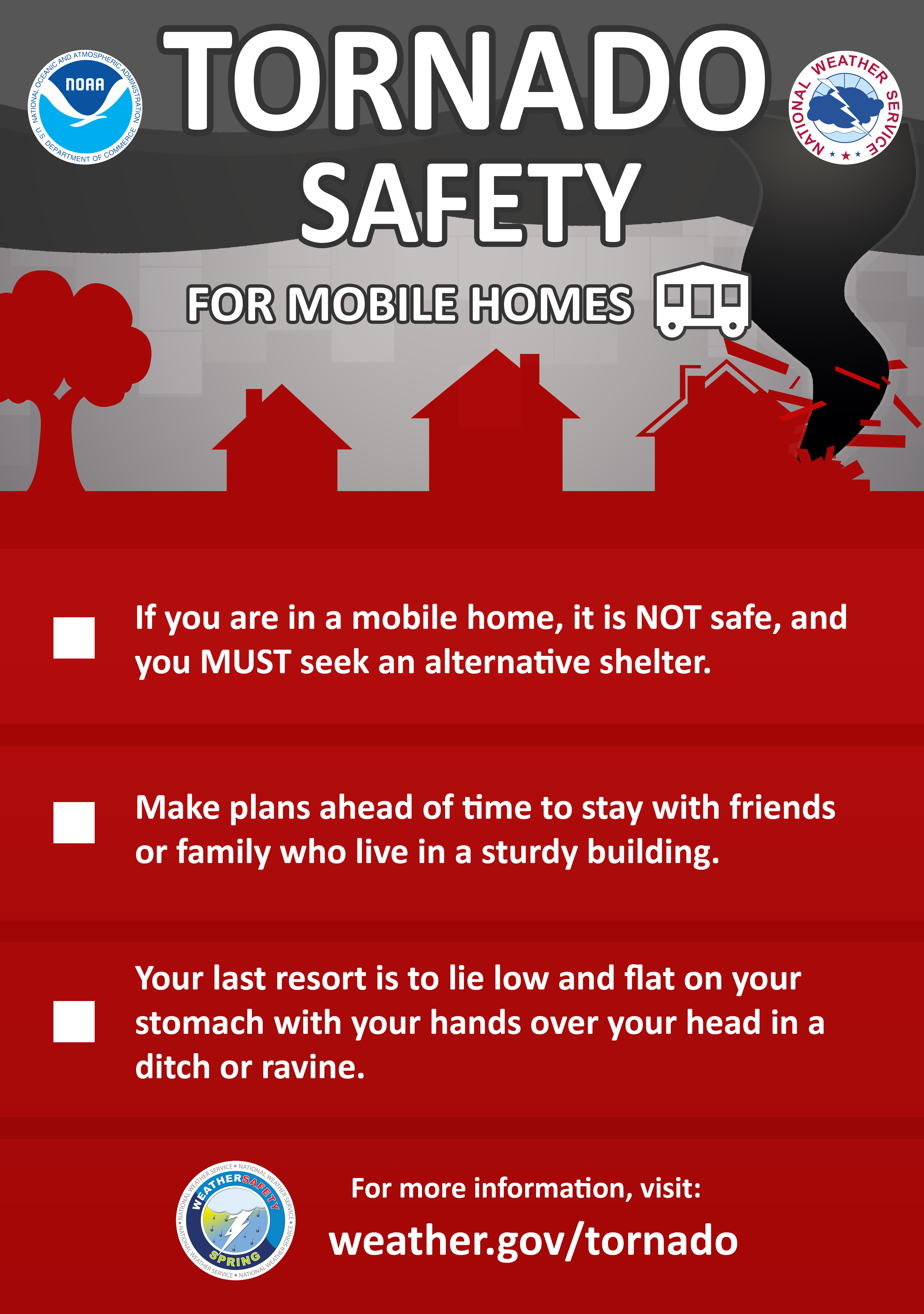
When your area is under a tornado warning, or if you see a tornado approaching, you should seek shelter immediately! Most injuries associated with high winds are from flying debris, so remember to protect your head. The following are safety tips for seeking shelter during high winds and tornadoes.
Tornado Safety Rules:
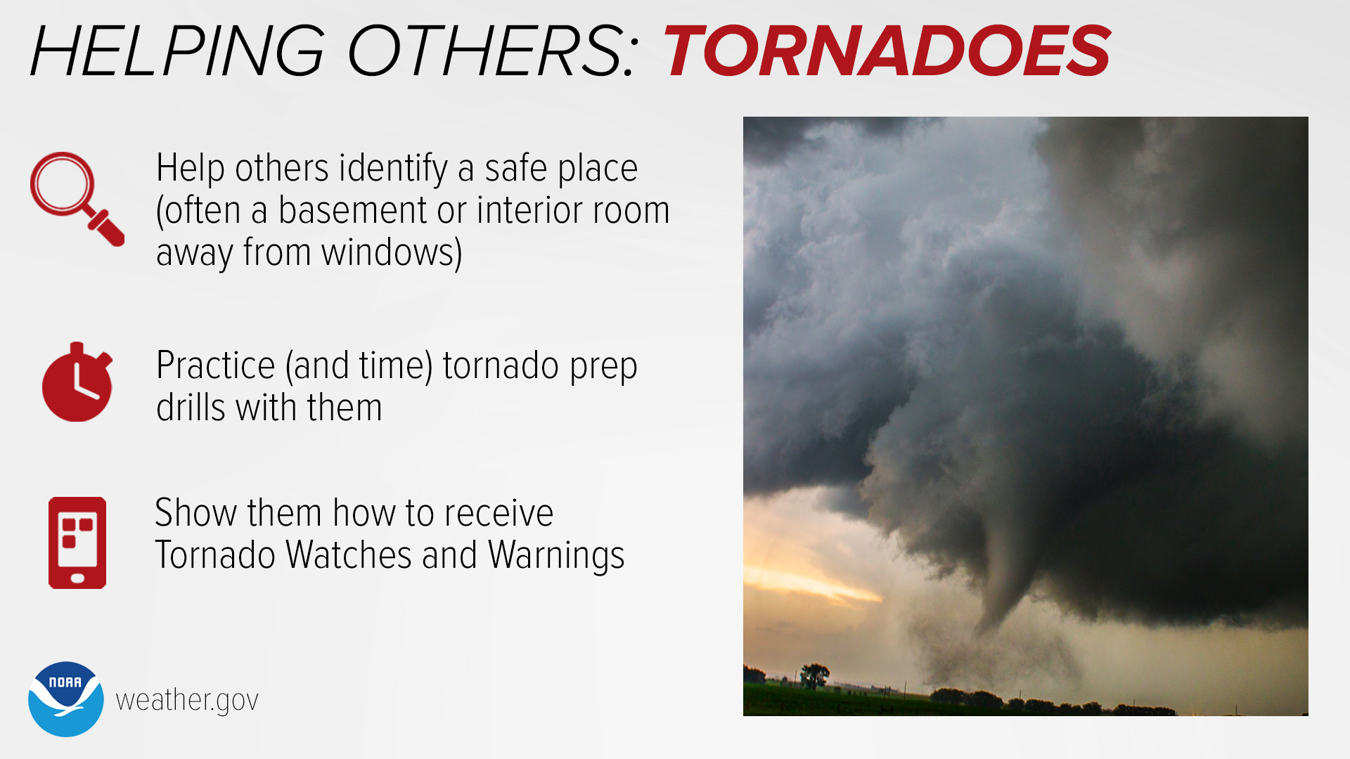
If you are in a home or small business:
Go to the basement or a small interior room such as a closet, bathroom or interior hallway without windows on the lowest level. Put as many walls between yourself and the outside as possible. If possible, get under something sturdy, such as a heavy table, or use a mattress to protect yourself from flying debris. Most injuries associated with high winds are from flying debris, so remember to protect your head. If available, put on a bicycle or motorcycle helmet to protect yourself from head injuries.

If you are in a large business, school, hospital, shopping center or factory:
Go to the designated shelter area. If a shelter area is not available, the best place is to go to an interior hallway on the lowest level. Stay away from the structurally weaker portions of buildings, such as windows and rooms with expansive roofs, which are more likely to collapse when tornadoes strike.

If you are in a mobile home or home on stilts:
Get out and take shelter in a sturdy building or storm shelter. If there is not one nearby, take shelter in the most interior room that has no windows, such as an interior bathroom or closet.
 |
 |
 |
If you are outside with no shelter available, there is no single research-based recommendation for what last-resort action to take, because many factors can affect your decision. Possible actions include:
While hail and straight-line winds generally do not garner the same attention or respect as tornadoes, they can be just as deadly! Hail can exceed the size of softballs and fall at speeds of over 100 mph, seriously injuring or killing anyone in its path. Straight-line winds can topple trees onto cars, houses, and power lines. Many deaths from straight-line winds are the result of trees falling onto the person, whether they are outside, in their house, or driving in their car. Strong straight-line wind events can even destroy buildings, especially mobile homes and manufactured homes.
High Winds, Hail, Tornadoes Infographics
(click to enlarge)
 |
.png) |
 |
 |
 |
 |
Thursday
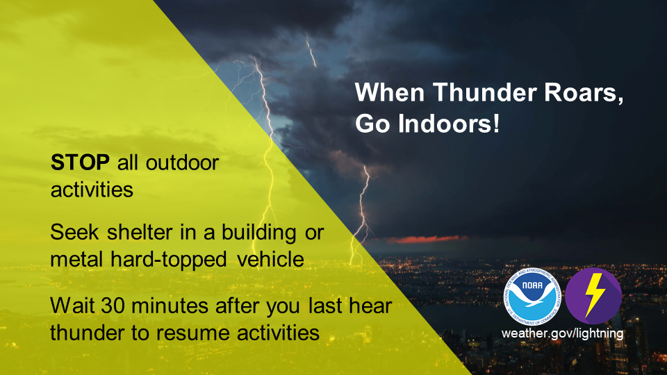
Lightning Safety
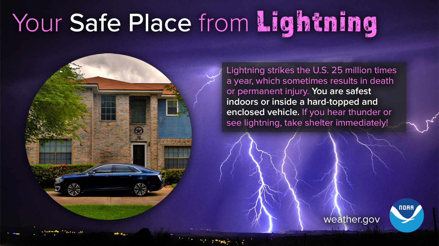
Lightning strikes the U.S. 25 million times a year, which sometimes results in death or permanent injury. You are safest indoors, or inside a hard-topped enclosed vehicle. Most of these tragedies can be avoided with a few simple precautions. When thunderstorms threaten, get to a safe place. Lightning safety is an inconvenience that can save your life.
All thunderstorms produce lightning and are dangerous. Lightning often strikes outside the area of heavy rain and may strike as far as 10 miles from any rainfall. Many lightning deaths occur ahead of storms or after storms have seemingly passed. Keep this simple fact in mind: if you can hear thunder, you are in danger. Also, don’t be fooled by blue skies. There is no such thing as “heat lightning.” All lightning comes as a result of a thunderstorm, and if you hear thunder, lightning is close enough to pose an immediate threat to you.
The most effective lightning safety action can be found in avoiding the lightning threat altogether. Have a lightning safety plan. If you have outdoor plans, know where you’ll go for safety and how much time it will take to get there. Make sure your plan allows enough time to reach safety. Before going outdoors, check the forecast for thunderstorms. If thunderstorms are in the forecast, consider postponing activities to avoid being caught in a dangerous situation. Finally, when outdoors, monitor the weather and be sure to look for signs of a developing thunderstorm such as darkening skies, flashes of lightning, or increasing wind. If you hear thunder, even a distant rumble, immediately activate your lightning safety plan and move to a safe place.
For more information about safety, please visit http://www.lightningsafety.noaa.gov.
The following lightning safety tips could one day save your life:
(click to enlarge)
 |
Lightning Infographics
(click to enlarge)
 |
 |
 |
 |
 |
 |
Did You Know Their Are Different Types of Lightning?
.png)
Friday
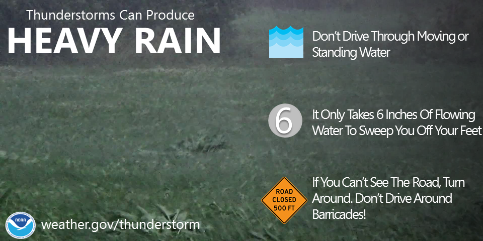
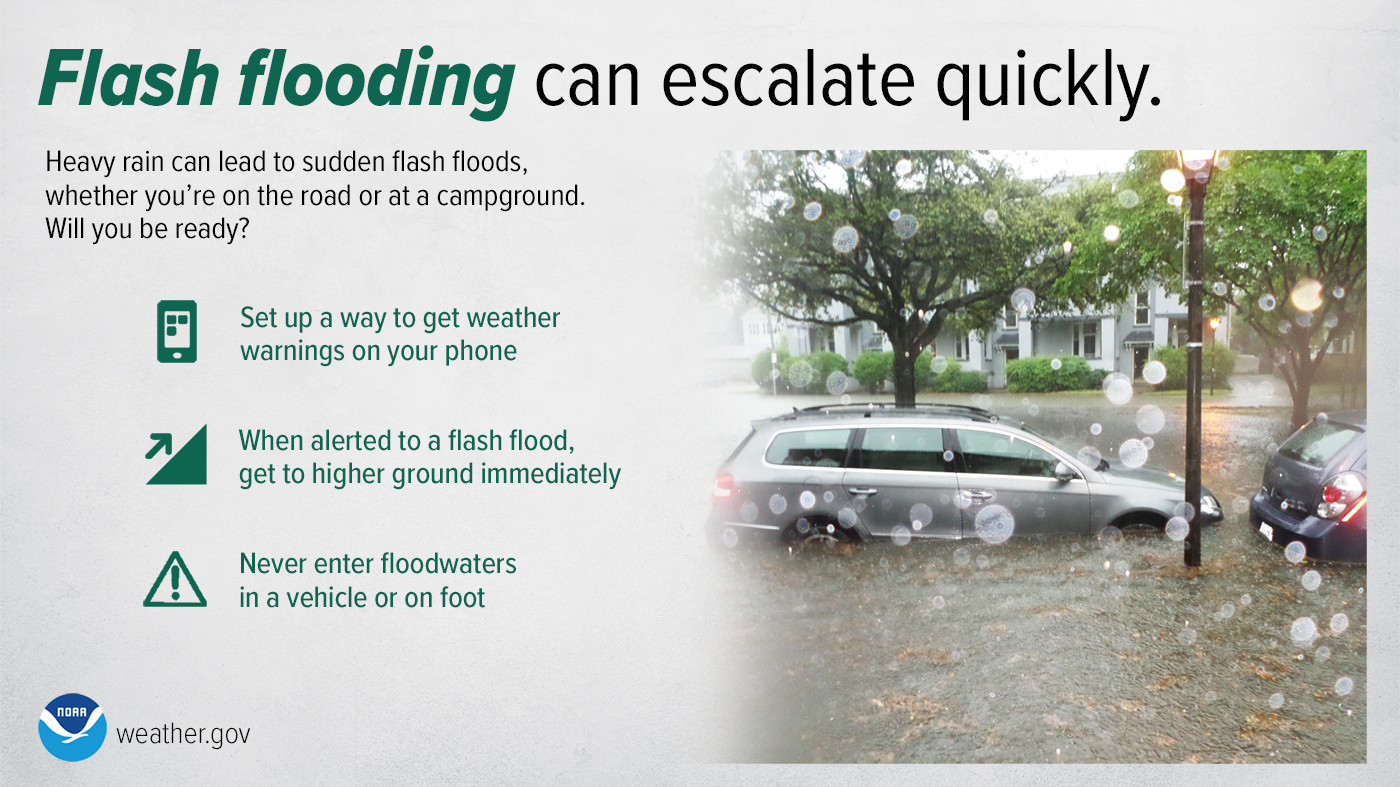
Flash Flood Safety
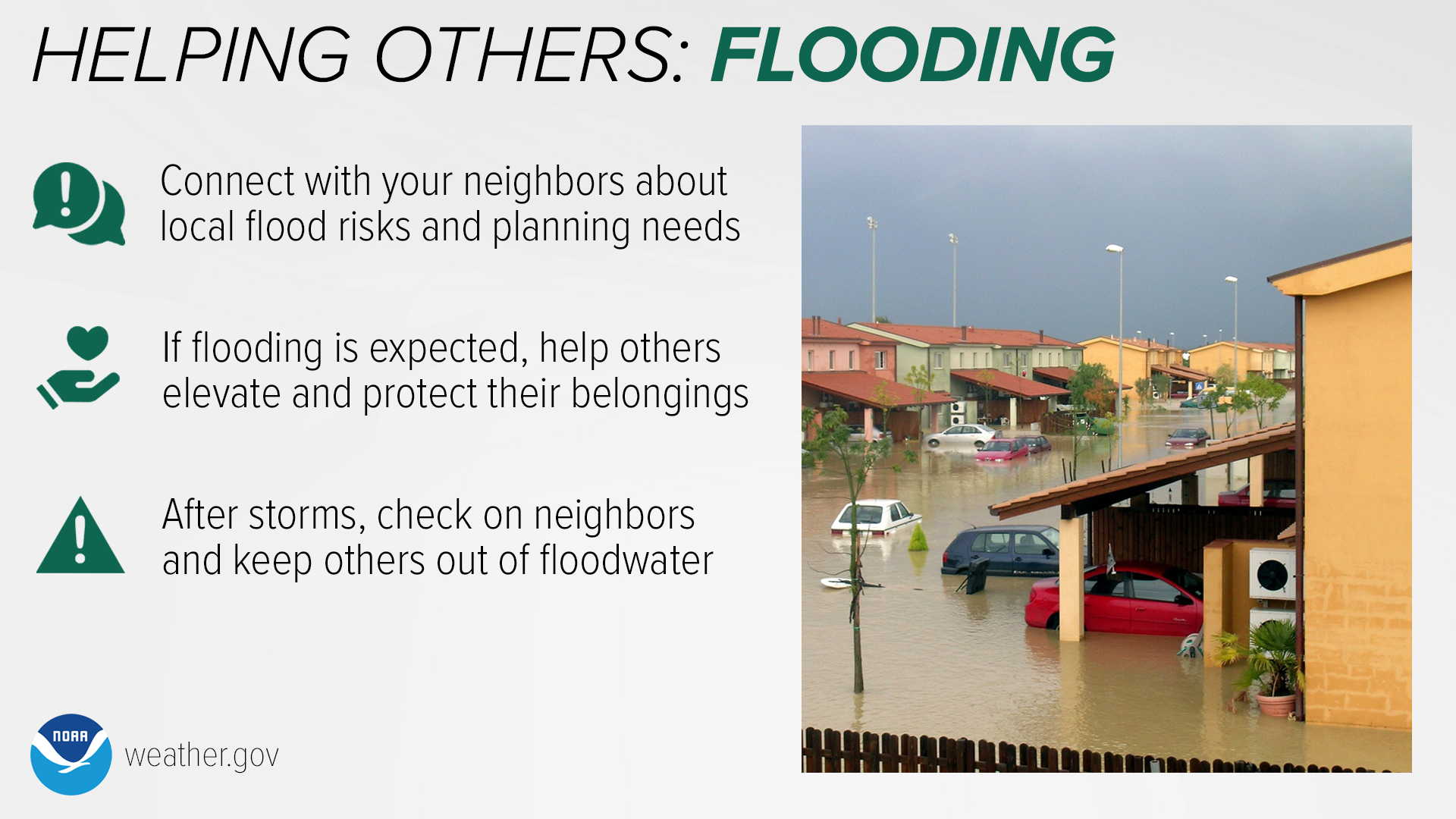
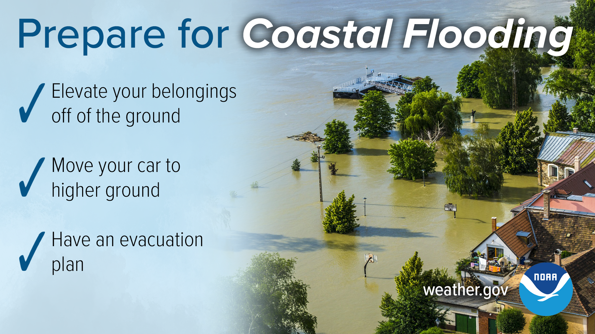
Flash flooding in North Carolina usually occurs when a large amount of rain falls in an area over a short period of time. The ground can only soak up so much water in a given time, and when the rain rate exceeds what can infiltrate into the ground or run off into drainage systems or streams, flooding is likely to occur. Hurricanes, tropical storms, and ordinary thunderstorms can produce flash flooding.
More people die from floods each year than from tornadoes, lightning, or hurricanes. Forecasters can usually predict where flooding will occur when a hurricane or tropical storm affects an area. However, when dealing with thunderstorms, predicting flash floods can be nearly impossible due to their isolated nature. Flash floods usually occur in low-lying areas where water can collect or in cities where water runoff from impermeable surfaces can fill roads or storm drains quickly.
Remember these flash flood safety tips:
Flooding Infographics
(click to enlarge)
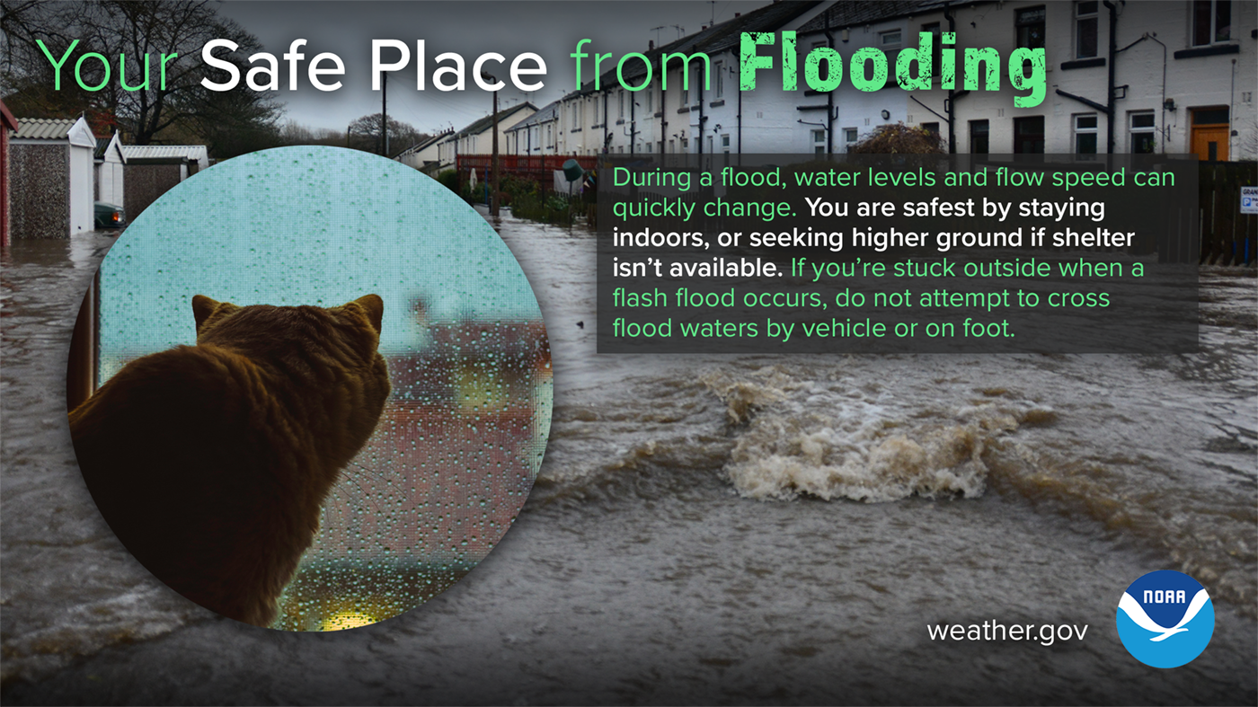
During a flood, water levels and the rate at which water is flowing can quickly change. You are safest by staying indoors, or seeking higher ground if shelter isn’t available. If you’re stuck outside when a flash flood occurs, do not attempt to cross flood waters by vehicle or on foot.
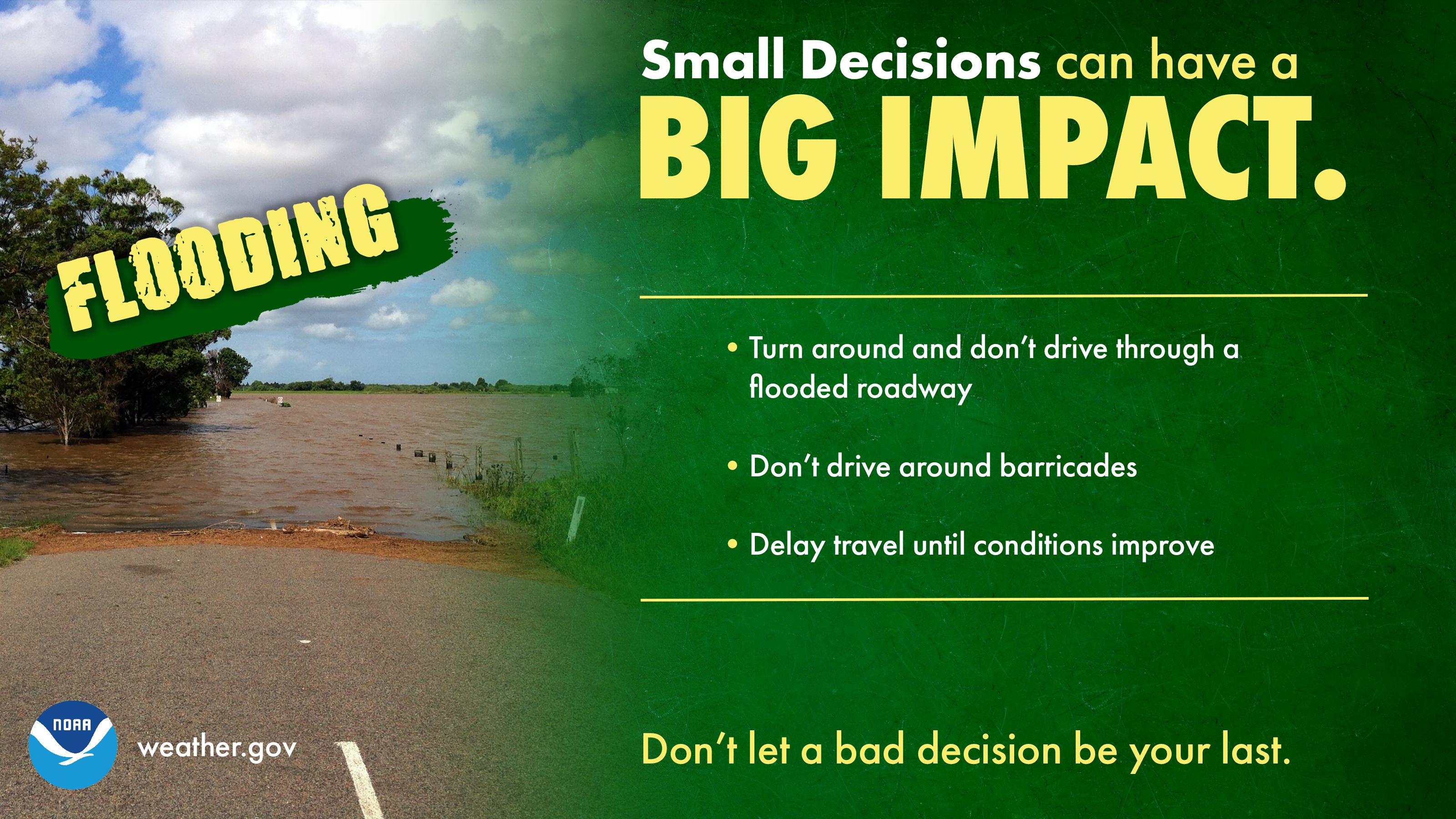
Most flood fatalities occur in vehicles, and it only takes 12 inches of water to sweep a car away. Sometimes the difference between life and death are small decisions. Small decisions like turning around and not driving through a flooded roadway, not driving around barricades, and delaying travel until conditions improve, can make a big impact on whether you keep your car...or even your life. Turn Around, Don’t Drown.
 |
 |
 |
 |
 |
 |
Flooding Infographics
(click to enlarge)
A Flood WATCH means Be Prepared.
A Flood WARNING means Take Action!
 |
.png) |
.png) |
.png) |
.png) |
.png) |
Saturday
Making A Plan
The first step in making sure that you and your family are prepared for severe weather is pledging to prepare. This includes developing a family emergency and communications plan. In short, know what to do before severe weather strikes by creating an emergency plan today. Visit https://www.ready.gov/plan to make your plan today!
Your family may not be together when a disaster strikes, so it is important to plan in advance: how you will get to a safe place; how you will contact one another; how you will get back together; and what you will do in different situations.
Planning for severe weather also includes…
Making A Plan Infographics
(click to enlarge)
 |
 |
 |
.png) |
Deaf & Hard of Hearing
#SeeAFlashDashInside
Severe Thunderstorm Safety (ASL Video)
Do you see a lot of strong thunderstorms in your area?
Check out this video in American Sign Language from the National Weather Service
to learn about what you need to know for the next big storm! youtu.be/V-t-9R2o8No
Tornado Safety (ASL Video)
You may only have seconds to get to your safe place when the next tornado occurs!
Learn where to shelter and how to get warning information from the National Weather Service with this video in American Sign Language!
youtu.be/aEPC5F4Zios
See a Flash, Dash Inside (ASL Video)
If you are outdoors and see a flash of lightning or feel the rumble of thunder, dash inside immediately! Check out our Lightning Safety video in American Sign Language and captioned in English!
Flood Safety Video (ASL Video)
Did you know flooding is the leading cause of death due to storms? Learn more about Flood Safety with this video in American Sign Language and captioned in English! youtu.be/RUf3ErtEbG4
NOAA Weather Radio (ASL Video)
NOAA Weather Radios receive warnings, watches, forecasts, and other hazard information 24 hours a day. Why would Deaf people want a radio? They can be used as a way to alert you or wake you up at night! Some come with flashing lights, vibrating alarm attachments, and color displays with text readouts for use by those with hearing loss. youtu.be/A4izxOnKnug
General Safety and Preparedness Tips (ASL Video)
Having a plan is important in times of emergency, and this includes building an emergency preparedness kit before a disaster. Learn how with this video in American Sign Language.
youtu.be/XWEvqy0e9-0
Severe Weather Safety (Español)
Su Lugar Seguro de Tornados (Your Safe Place from Tornadoes)
Los tornados pueden ser extremadamente peligrosos. Los lugares seguros incluyen refugios para tormentas y sótanos, pero si no están disponibles, una habitación interior sin ventanas también puede protegerle. Si recibe un aviso de tornado, ¡busque refugio de inmediato! weather.gov/safety/tornado

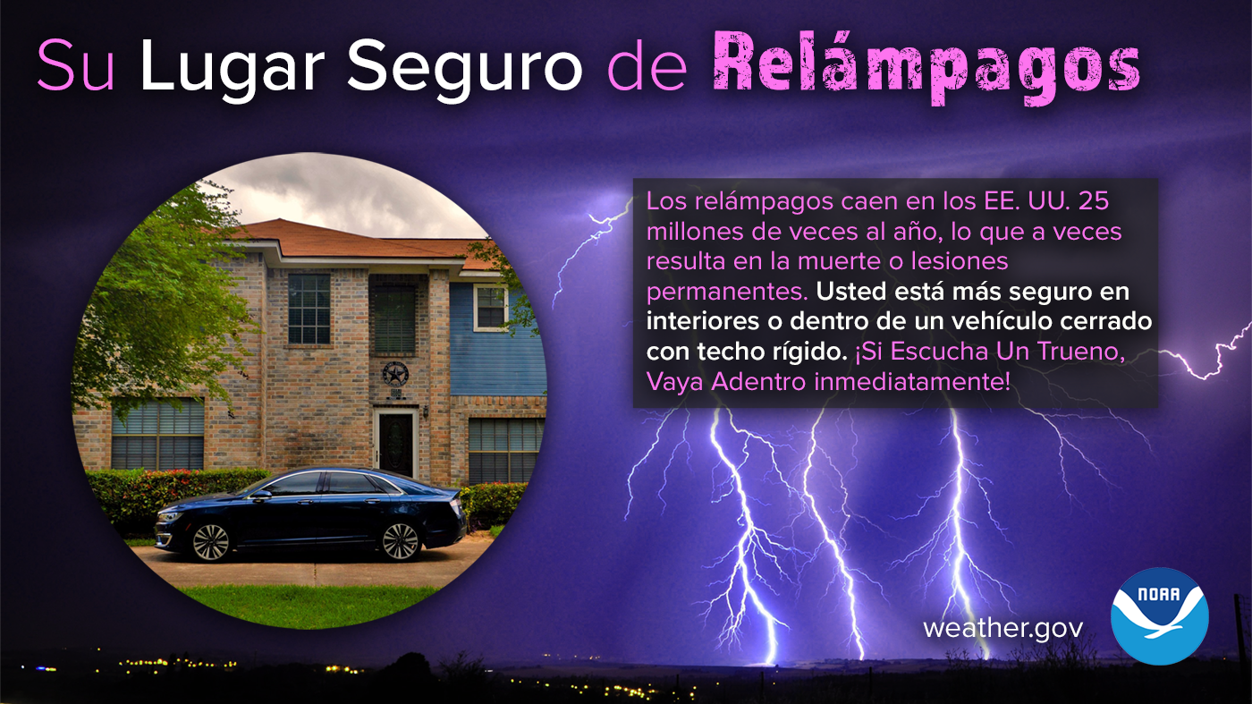
Su Lugar Seguro de Relámpagos (Your Safe Place from Lightning)
Los relámpagos caen en los EE. UU. 25 millones de veces al año, lo que a veces resulta en la muerte o lesiones permanentes. Usted está más seguro en interiores o dentro de un vehículo cerrado con techo rígido. Manténgase preparado para las condiciones del tiempo y obtenga más información sobre la seguridad contra relámpagos: weather.gov/safety/lightning
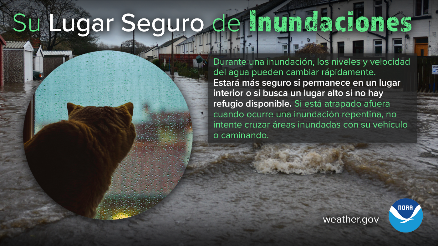
Su Lugar Seguro de Inundaciones (Your Safe Place from Flooding)
Durante una inundación, los niveles y velocidad del agua pueden cambiar rápidamente. Estará más seguro si permanece en un lugar interior o si busca un lugar alto si no hay refugio disponible. Si está atrapado afuera cuando ocurre una inundación repentina, no intente cruzar áreas inundadas con su vehículo o caminando. Obtenga más información sobre la seguridad contra inundaciones en weather.gov/safety/flood
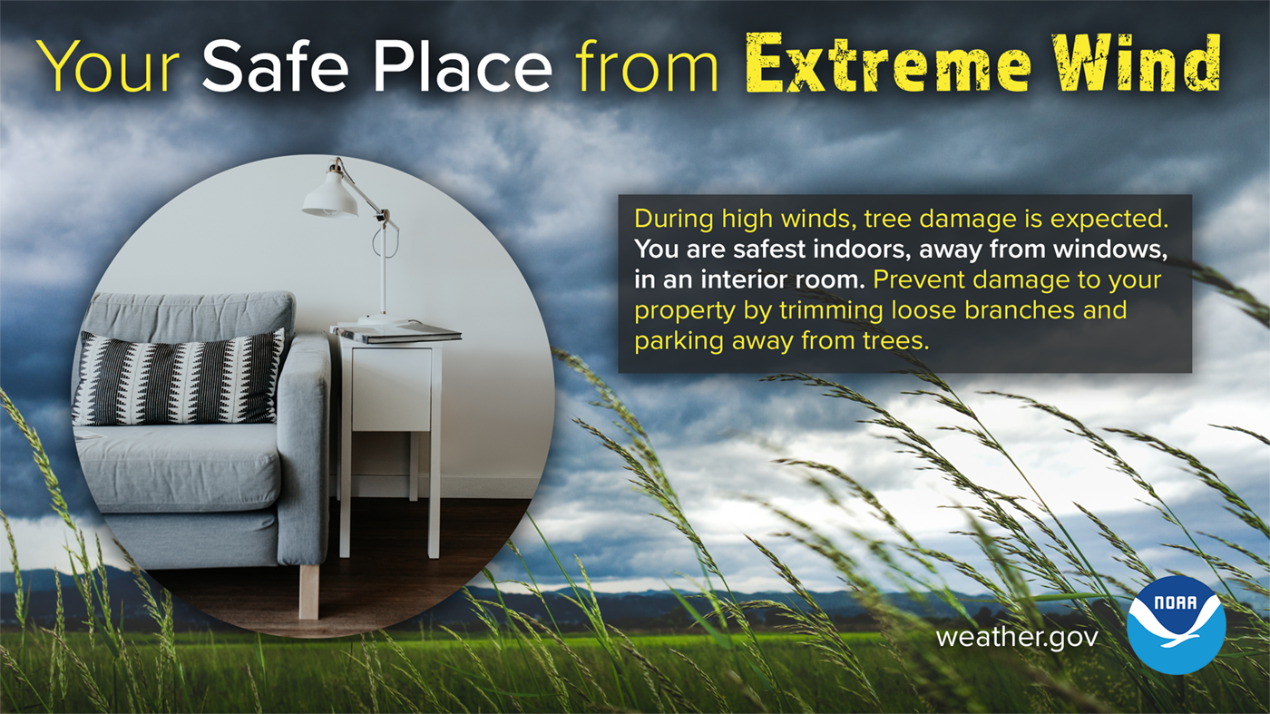
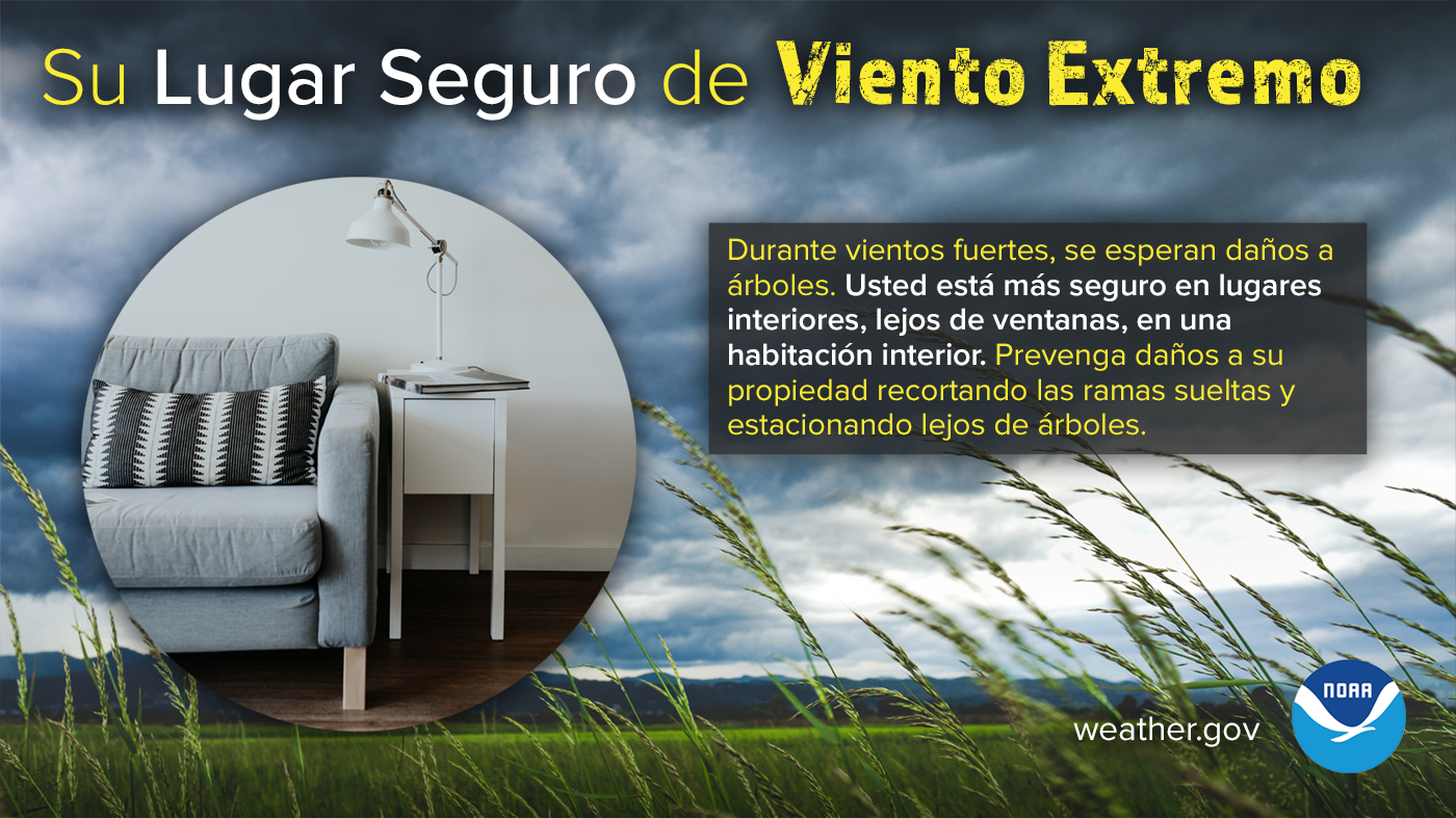
Su Lugar Seguro de Viento Extremo (Your Safe Place from Extreme Wind)
Durante vientos fuertes, se esperan daños a árboles y los objetos sueltos podrían volar por el aire y ser peligrosos. Usted está más seguro en lugares interiores, lejos de ventanas, en una habitación interior. Manténgase preparado para las condiciones del tiempo y obtenga más información sobre la seguridad de vientos fuertes: weather.gov/safety/wind
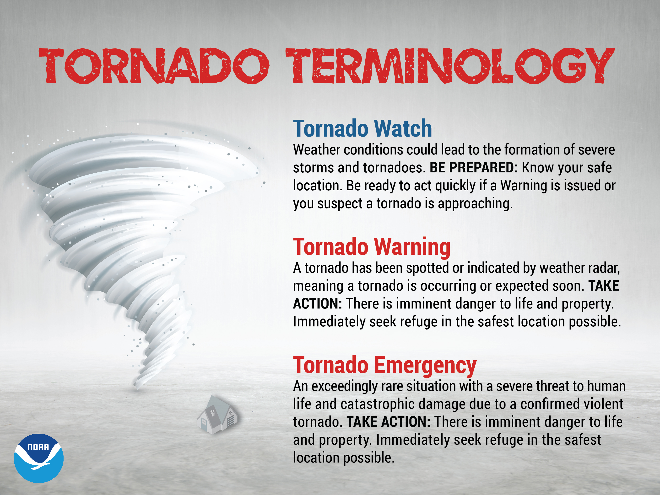
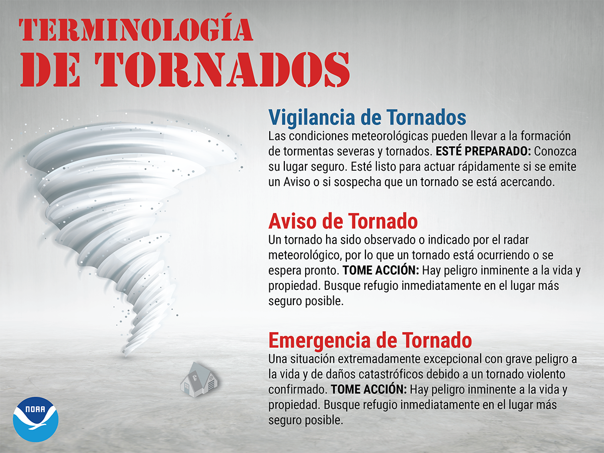
Terminología De Tornados (Tornado Terminology)
Una VIGILANCIA de tornados significa ESTÉ PREPARADO. Un AVISO o una EMERGENCIA de tornado significa TOME ACCIÓN.
En caso de una vigilancia de tornados, preste mucha atención al tiempo y esté listo para actuar, porque existe la posibilidad de tornados. En caso de un aviso de tornado, busque refugio inmediatamente, y diríjase a una habitación interior en la planta más baja de un edificio seguro, porque un tornado está ocurriendo u ocurrirá pronto. Evite las ventanas y cúbrase la cabeza para protegerse de los escombros lanzados por el tornado. ¡Tomar acción de antemano puede ayudar a salvar vidas! weather.gov/safety/tornado-ww
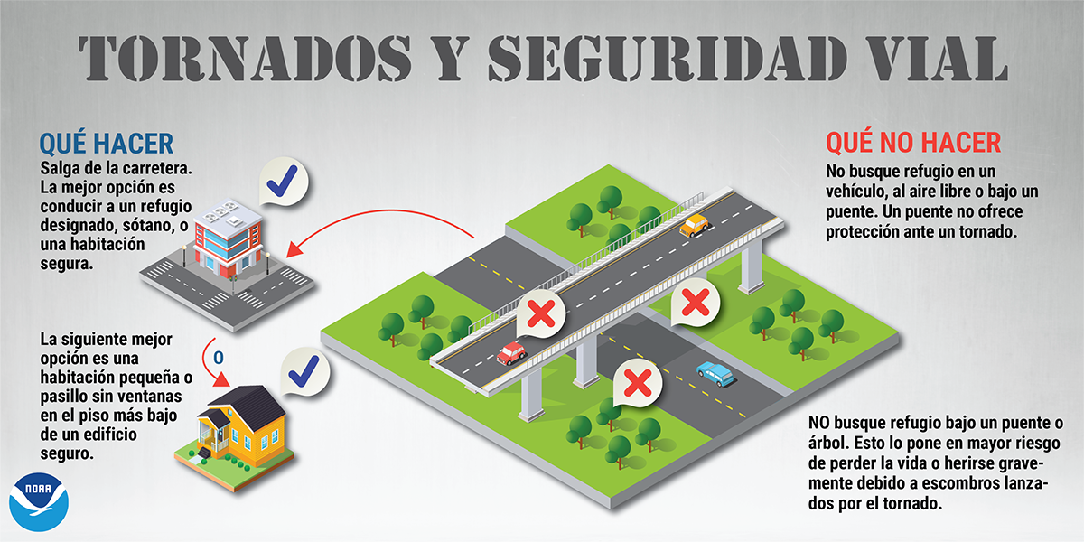
Terminologa De Tornados (Tornadoes and Road Safety)
Durante un tornado, buscar refugio en un vehículo o bajo un puente NO es seguro. Si está al aire libre durante un aviso de tornado, la mejor opción es conducir a un refugio designado, sótano o una habitación segura. weather.gov/safety/tornado #SpringSafety
Vigilancia vs Aviso de Tormentas Severas (Thunderstorm Watch vs. Warning)
Una VIGILANCIA de tormentas severas significa ESTÉ PREPARADO. ¡Un AVISO de tormenta severa significa TOME ACCIÓN! Si hay una vigilancia de tormentas severas en efecto, manténgase informado y esté listo para actuar, porque tormentas severas son posibles. En caso de un aviso de tormenta severa, refúgiese en un edificio seguro. Tiempo severo está ocurriendo u ocurrirá en breve. weather.gov/safety/thunderstorm-ww

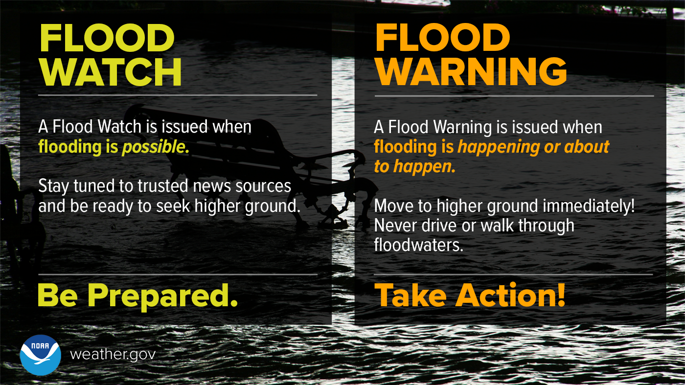
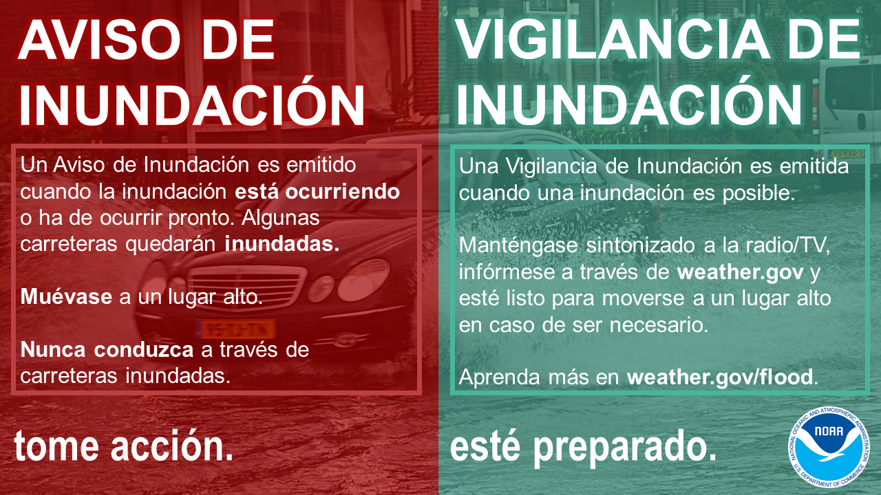
Aviso vs Vigilancia de Inundaciones (Flood Warning vs. Watch)
Un AVISO de inundación significa TOMAR ACCIÓN. Una VIGILANCIA de inundación significa PREPARARSE. Cuando se emite un Aviso, significa que inundaciones son inminentes o que ya están ocurriendo. Cuando una Vigilancia de Inundación está en efecto, significa que es posible que ocurra una inundación en su área. weather.gov/safety/flood-watch-warning #FloodSafety
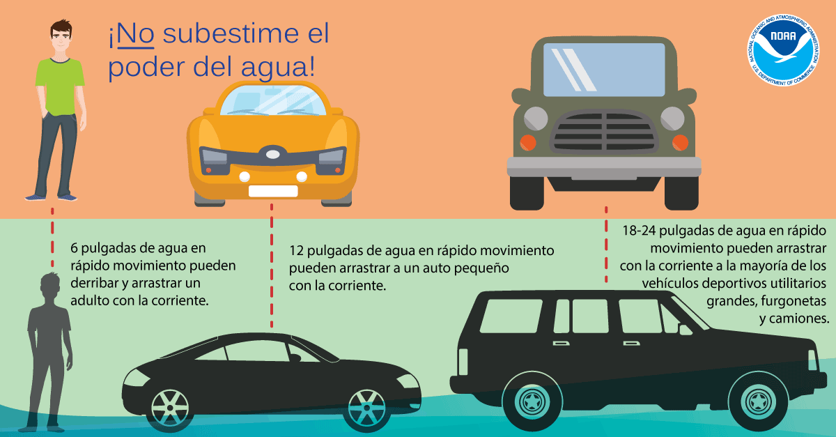
Graifica - El Ponder del Agua (Infographic - Power of Water)
No subestime el poder del agua. Sólo se necesitan 6 pulgadas de agua en rápido movimiento para derribar y arrastrar a un adulto, y 12 pulgadas de agua para arrastrar a un automóvil pequeño. ¡Dé la Vuelta, No Se Ahogue! weather.gov/safety/flood-turn-around-dont-drown
Find us on social media:
You can also contact:
Erik Heden (Erik.Heden@noaa.gov) for additional information about Severe Weather Preparedness.


 Youtube
.png) Surf Forecast/Rip Currents
Surf Forecast/Rip Currents Map View
 Weather Hazard Briefing (when applicable)
 Forecaster Discussion
 Marine
 Text Products
.png) Skywarn
Skywarn Submit Storm Reports
 Coastal Flood