 SMALL BOAT SAFETY SMALL BOAT SAFETY
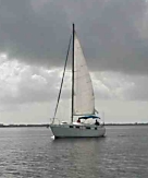
Boating is a favorite pastime in Florida, but sudden changes in the weather can turn an otherwise sunny day into a dark and scary afternoon.
Typical weather across the inland and coastal waters of Florida poses many hazards to small boats. All of the National Weather Service offices in Florida, along with the National Hurricane Center, issue many types of warnings, watches and advisories to inform boaters on Florida waters of the potential weather-related dangers. Smart boating means planning for adverse weather and always wearing a personal flotation device.
 Local weather service offices also issue a short term forecast that covers a period up to six hours so boaters can plan their days on the water. Local weather service offices also issue a short term forecast that covers a period up to six hours so boaters can plan their days on the water.
The NOAA Weather Radio is the best way to receive immediate warnings and other weather forecast information from the local National Weather Service office. Information is broadcasted on different radio frequencies across Florida, 24 hours per day, each day of the year. The weather radios are equipped with alarms that alert people of the warnings, watches and advisories issued by the local weather service office. The Coast Guard also rebroadcasts some of these warnings, advisories and statements across the marine radio emergency channel.
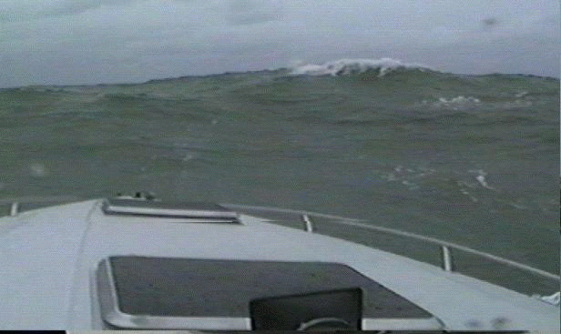
 Boaters need to be warned of any changes to the current weather. Some examples of dangerous weather that can occur include strong winds, rough seas, lightning and waterspouts. Generally, wind gusts of 34 knots (39 mph) or more are often strong enough to capsize small boats, especially when they catch the boater off-guard. Strong winds are usually generated by thunderstorms or fast moving rain showers over the waters of Florida. Strong winds also can cause five-foot or greater seas, which makes it very difficult to control the boat. For the most part, sustained winds of around 18 knots (22 mph) can produce seas of around five feet across most bodies of water in Florida. A special marine warning would be issued if the wind gusts exceed 34 knots (39 mph) producing eight-foot seas in some areas. Boaters need to be warned of any changes to the current weather. Some examples of dangerous weather that can occur include strong winds, rough seas, lightning and waterspouts. Generally, wind gusts of 34 knots (39 mph) or more are often strong enough to capsize small boats, especially when they catch the boater off-guard. Strong winds are usually generated by thunderstorms or fast moving rain showers over the waters of Florida. Strong winds also can cause five-foot or greater seas, which makes it very difficult to control the boat. For the most part, sustained winds of around 18 knots (22 mph) can produce seas of around five feet across most bodies of water in Florida. A special marine warning would be issued if the wind gusts exceed 34 knots (39 mph) producing eight-foot seas in some areas.
 Another danger to boaters is a severe thunderstorm that can turn calm waters into dark and rough seas. Florida is considered the thunderstorm capital of the United States with areas of west-central Florida near Tampa having the highest frequency of days per year with thunderstorms. Another danger to boaters is a severe thunderstorm that can turn calm waters into dark and rough seas. Florida is considered the thunderstorm capital of the United States with areas of west-central Florida near Tampa having the highest frequency of days per year with thunderstorms.
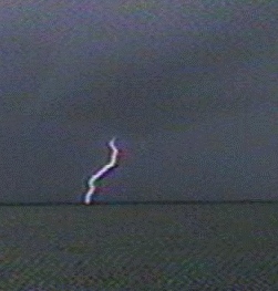
Lightning is also a hazard for boaters. There are no warnings for lightning issued by the National Weather Service but the short term forecast and marine weather statements will most likely mention the possibility of cloud to water lightning strikes. Since lightning is produced by thunderstorms, Florida frequently leads the nation in lightning related deaths and injuries and many of these occur over the water.
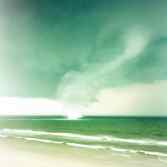 Waterspouts are similar to tornadoes over water. Waterspouts are generally broken into two categories: fair weather waterspouts and tornadic waterspouts. Tornadic waterspouts are simply tornadoes that form over water and they have the same characteristics as a land tornado. Waterspouts are similar to tornadoes over water. Waterspouts are generally broken into two categories: fair weather waterspouts and tornadic waterspouts. Tornadic waterspouts are simply tornadoes that form over water and they have the same characteristics as a land tornado.
Fair Weather waterspouts are usually less dangerous. The term fair weather comes from the fact that these type of waterspouts form during fair and relatively calm weather. Fair weather waterspouts usually form along dark flat bases of a line of developing cumulus clouds. These type of waterspouts generally are not associated with thunderstorms whereas tornadic waterspouts develop in severe thunderstorms. Tornadic waterspouts develop downward in a thunderstorm while a fair weather waterspout begins to develop on the surface of the water and works its way upward. By the time the funnel is visible, a fair weather waterspout is near maturity.
Fair weather waterspouts form in light wind conditions so they normally move little. If a waterspout moves onshore, the National Weather Service issues a tornado warning as some of them can cause significant damages and injuries to people. The best way to avoid a waterspout is to move at a 90-degree angle to its apparent movement. One should never try to move closer to investigate a waterspout as some can be just as dangerous as tornadoes.
|

