
Hard Freeze Grips Central Gulf Coast
December 5, 2006
Late Sunday evening on December 3rd, 2006, surface arctic high pressure developed southeastward and was poised to bring the coldest temperatures of the 2006-2007 Fall-Winter Season thus far to the Deep South. By Tuesday morning, the 5th of December, surface high pressure was in firm control, and under clear skies and relative light wind conditions, surface temperatures fell into the upper teens to upper 20s across a large portion of the Central Gulf Coast Region.
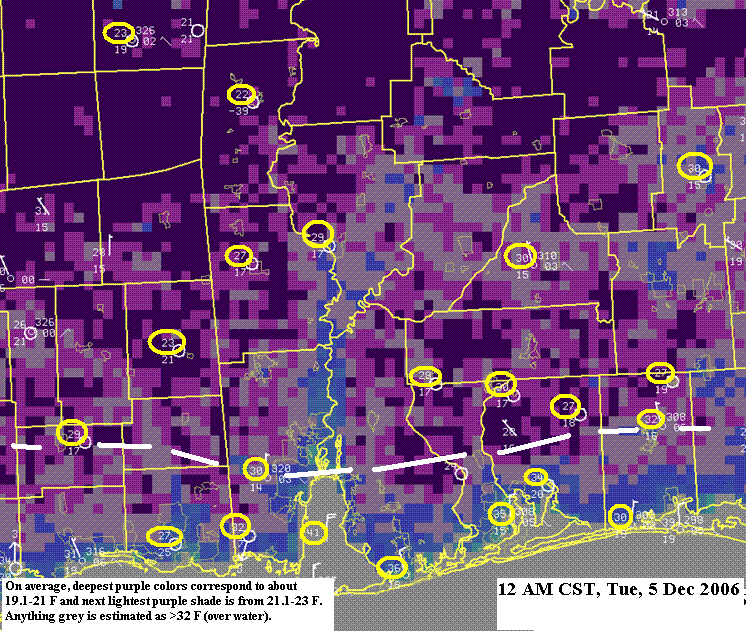
A Hard Freeze Warning was issued early Monday (December 4th, 2006 at 4am) for Tuesday morning's hard freeze event that was forecast to occur north of a line from approximately Wiggins, MS to Mobile, AL to Crestview, FL (see dashed white line in images below).
Definition - Hard Freeze Warning - at least 5 hours of surface temperature below 26°F is expected. People, pets, plants, and pipes need protection from this type of cold weather.
Surface temperatures by midnight on December 5th had fallen into the low 20s over interior portions of our forecast area with temperatures in the mid 30s closer to the coast as seen in the imagery below.
The imagery below shows the sea surface temperature observations and satellite imagery estimates of colder temperatures around the region for various hours.
NOTE: The digital portion of the images below is what is referred to as 'satellite skin temperature' and in this case was found to be about 2°F colder than the actual surface temperature which is measured at 2 meters (or 6 feet) above ground. In this manner, and in the absence of clouds overhead, we can estimate the surface temperature within approximately 1-2°F of the actual for most locations
Typically, in situations like this (characterized by strong arctic-origin surface high pressure with relative light winds and clear sky conditions), if you live near a river valley and very close to the water you will be warmer than surrounding areas (as shown along major river basins like the Alabama, Tombigbee and Pascagoula in the imagery above). Also, if you live on hill tops where winds are a bit higher (i.e., a light wind is defined as less than or equal to 6mph), you may also be a little warmer. However, if you are away form the coast and live within the interior valleys with no water source (such as positions of interior southeast Mississippi, along the Alabama-Florida border and over far inland portions of southwest Alabama), you will experience some of the coldest minimum surface temperatures. This indeed happened in this event! Typically, as surface high pressure builds further east the second night behind a cold (and sometimes even the third night, albeit more rare) will actually be colder than the first night due to the winds dying off and the evaporation of any rainwater that may fallen in association with the cold front.
Additional Monday afternoon (December 4th) maximum and Tuesday morning (December 5th) minimum surface temperatures over portions of interior southeastern Mississippi, southwestern Alabama and the extreme northwestern Florida Panhandle can be viewed here. A Freeze Watch was issued much earlier for this event on Saturday, December 2nd.
Acknowledgements: Page initially created by Jeff Medlin (Meteorologist In Charge). Page updated by Morgan Barry (Forecaster).
LAST UPDATED: October 2016


 Follow us on YouTube