
Gulf Coast Heavy Rain Event
September 27-29, 2015
A complex set of conditions came together to produce extreme amounts of rainfall across the north central Gulf Coast in late September of 2015. Rain totals in some areas approached or exceeded 10 inches, resulting in numerous stalled vehicles, water rescues and reports of flash flooding across coastal portions of the NWS Mobile/Pensacola County Warning Area.
 Atmospheric Ingredients
Several factors set the stage for heavy rains across the north central Gulf Coast. In the mid-levels of the atmosphere, a large closed low pressure system was located over eastern Texas and the western Gulf of Mexico early on September 27th. This system was marked by deep southerly flow over the central Gulf of Mexico, bringing moisture-laden air northward. In addition, the large upper level low pressure system featured an extensive area of diffluence aloft across the northern Gulf Coast. Diffluence is characterized by the spreading out of air; a necessary ingredient in the upper levels of the atmosphere for efficient, long-lived precipitation production at the surface.
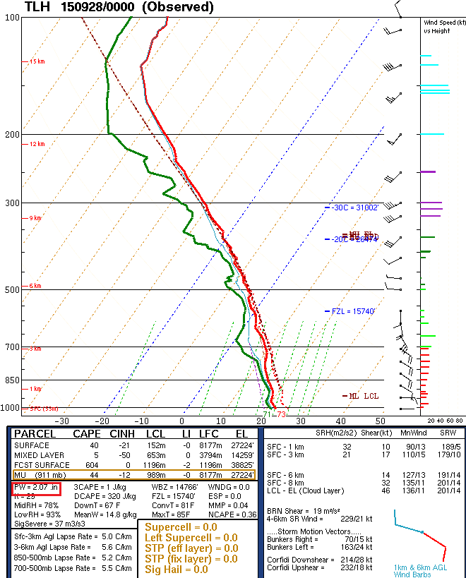
The 00 UTC balloon sounding from Tallahassee (figure to the right; with precipitable water value outlined in red near the bottom left) shows extremely deep moisture in the column with over 2 inches of precipitable water (PWAT) analyzed. This value is nearly two standard deviations above normal for this time of year!
Precipitable water values at 00 UTC on September 28.
Image via SPC Mesoanalysis page.
The lower levels of the atmosphere featured a complex pressure pattern that also contributed to the intense rainfall. Two distinct areas of low pressure were present in the Gulf on the morning of September 27th. The first was an area of disturbed weather in the far southern portions of the Gulf of Mexico, but this area would lift to the north and east and not directly affect our area. The second area of low pressure was the surface reflection of the aforementioned upper low over Texas. This feature progressed slowly east across the northern Gulf Coast during the 27th-29th timeframe and would have the greatest impact on surface boundaries and precipitation totals in our area. Air converging at the surface and diverging aloft are necessary ingredients for sustained heavy precipitation and the influence of both the upper low and surface low set the stage for a prolonged heavy rain event for the area.
Two distinct regimes of surface inflow contributed to heavy rain across the area. Ahead of the surface low there was relatively strong (20-25 knot) east-southeasterly flow feeding into the area of heaviest precipitation. Further to the west, another inflow channel featured deep southerly flow bringing tropical moisture northward from the western Caribbean. The convergence of these two inflow regimes, when coupled with favorable conditions aloft and modest instability, resulted in extremely efficient and long-lived precipitation production.
One factor that certainly mitigated the effects of this heavy rainfall was the dry antecedent conditions found across the region. Prior to this event, the Mobile Regional Airport had an August-September rainfall deficit of nearly 7 inches and, correspondingly, rivers and streams in the area were running well below normal before the heavy rainfall started.
Impacts
Although heavy rain fell across portions of all of our coastal counties (from west to east: Mobile, Baldwin, Escambia FL, Santa Rosa, and Okaloosa Counties) there were two distinct maxima in rainfall where storm totals exceeded 7 inches. The first bullseye occurred over central and southern Mobile County during the day and into the evening hours of September 27th. A relative minimum in rainfall occurred over Baldwin and Escambia (FL) Counties with the exception of areas within about 20 miles of the immediate coast. The second precipitation bullseye occurred further to the east in southern Santa Rosa County and Okaloosa County during the day and into the evening on September 28th.
Mobile County
 The heavy rainfall in Mobile County was largely confined to the southern two thirds of the county with the highest totals found along and just to the west of Interstate 65 and extending down to the south and west. A map of the storm total accumulation from the KMOB radar (Mobile, AL) can be seen to the right.
The Mobile Regional Airport recorded a storm total of 7.79 inches for this event (September 27-28). A 1-day total of 7.5 inches at Mobile Regional Airport on September 27th was the 10th highest 1-day storm total rainfall in Mobile’s exceptionally long period of record (1871 to present).
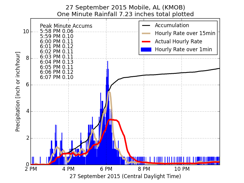
Below is a plot of observed rainfall rates from the Mobile Regional Airport graciously shared Daryl Herzmann from Iowa State University. This graph shows 8 inch per hour rain rates were sampled around 6pm on the evening of September 27th with nearly an hour featuring rain rates above 2 inches per hour. For a few minutes near 6pm we were recording over a tenth of an inch of rain every minute!!
The Mobile Regional Airport was most certainly not the only area to receive flooding rains. A parking lot at New Hall on the campus of the University of South Alabama flooded, leaving numerous stalled cars and a large sinkhole. Another problem area was found near and slightly west of where Airport Blvd meets Interstate 65. Swift water rescues were requested in this area after many vehicles stalled attempting to drive through flooded roadways.


A few miles to the south there was more flooding along Girby Rd. near the Environmental Studies Center, an area that was particularly susceptible to flooding in the late April 2014 heavy rain event.


Flooding along Girby Rd. in Mobile, AL. Images via Scott Elmore
A truly incredible long duration radar loop of the rains affecting Mobile County can be found on our YouTube page.

KMOB radar loop from September 27
List of CoCoraHS storm total rainfall observations for Mobile County, AL can be viewed below.

Florida Panhandle and Baldwin County (AL)
After a relatively quiet overnight period where heavy rains primarily fell very close to the coast in Baldwin County in AL and Escambia County in FL, day two of the event took aim on the western Florida Panhandle counties. CoCoraHS totals from Baldwin County in AL and Escambia County in FL can be seen in figures below respectively.
CoCoraHS rainfall observations for Baldwin County, AL
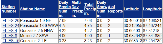
CoCoraHS rainfall observations for Escambia County, FL
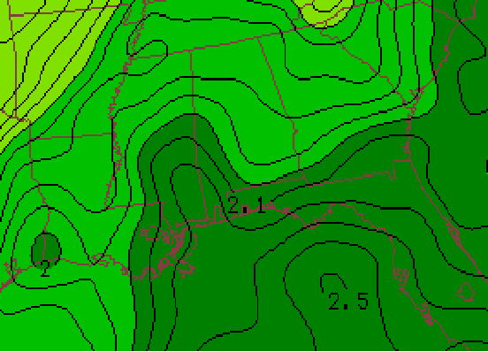
 The atmospheric setup was largely unchanged from the day before with more than adequate moisture (a PWAT near 2 inches), dual inflow channels showing up on radar imagery and continued favorable diffluence aloft, albeit a bit further east than the day before.
After a relative lull in heavy precipitation over most of Baldwin County in AL and Escambia County in FL, we can see a marked increase in total accumulated precipitation over central and southern Santa Rosa County and the majority of Okaloosa County in the storm total accumulation map from KEVX (Eglin AFB) radar to the right. Of note are the incredible radar-indicated totals of over 10 inches across southern Santa Rosa County near Navarre Beach and especially to the east over Fort Walton Beach and Destin where rainfall totals approach 15 inches.
In general, we received fewer reports of flooded roads and stalled cars in these areas which can be attributed to rural inland terrain (vs. urban) over which the rain fell as well as the dry conditions leading up to this event. We certainly did receive reports of flooded roads from the more developed beach areas of the aforementioned counties in northwest Florida and Baldwin County in Alabama.

Flooding near Destin, FL. Image via Tina Harbuck.
Incredible storm total accumulations occurred in southern Santa Rosa and Okaloosa Counties as can be seen in the CoCoraHS total precipitation in the figures below respectively.
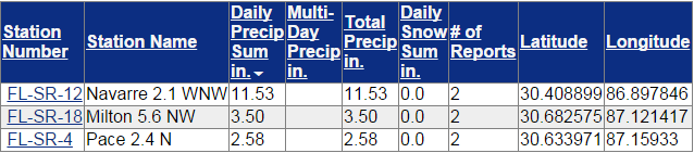
CoCoraHS rainfall observations for Santa Rosa County, FL
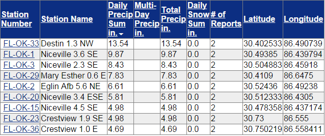
CoCoraHS rainfall observations for Okaloosa County, FL
Another long duration radar loop showing the event over the Florida Panhandle counties can be seen on our YouTube page. Of note is the duration and radar-indicated intensity over the southern portions of both counties.
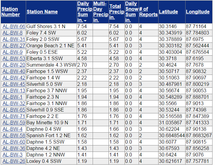
A list of storm total accumulations from selected sites across the area can be seen in the image below. Some of the totals from the Gulf Coast beaches are simply stunning. This event erased the late summer rainfall deficit in many of the affected areas. One can only imagine the impacts had our soil moisture and river levels been running above normal when these rains began to fall.

Selected event total precipitation measurements from NWS Mobile
Acknowledgements: Page created by Morgan Barry (Forecaster) and Ryan Rogers (Forecaster).
LAST UPDATED: December 2017


 Follow us on YouTube