National Weather Service United States Department of Commerce

National Weather Service, Mobile-Pensacola


Late January Gulf Coast Tornado Event
January 21, 2017


Summary of all Local Storm Reports (LSRs) across the area on January 21st and LSRs across the region for this tornado outbreak.


...NWS Damage Survey For The 01/21/2017 Perry County Mississippi Tornado...


  • perry_county_path.jpg

Click to Enlarge

KML Icon Shapefile Icon
  • perry_county1.jpg
  • perry_county2.jpg
  • perry_county3.jpg
  • perry_county4.jpg

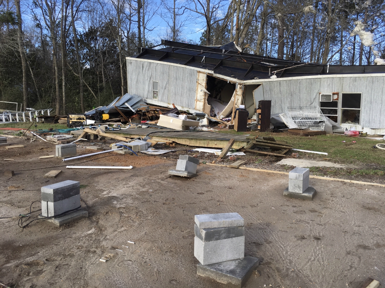
Runnelstown, MS Tornado...

Rating:                 EF-2
Estimated Peak Wind:    125 mph
Path Length /statute/:  7.1 miles
Path Width /maximum/:   600 yards
Fatalities:             0
Injuries:               1

Start Date:             Jan 21 2017
Start Time:             4:05 am CST
Start Location:         1.3 miles WNW of Runnelstown, MS
Start Lat/Lon:          31.38006734, -89.14514009

End Date:               Jan 21 2017
End Time:               4:13 am CST
End Location:           5.5 miles NE of Runnelstown, MS
End Lat/Lon:            31.41937511, -89.03423301

Survey summary: The tornado entered extreme NW Perry County, MS from
NE Forrest County 2 miles WNW of Runnelstown, MS and continued to
move NE at 45 to 50 MPH before lifting 5.5 miles NE of Runnelstown.
Two main areas along the path had significant damage, with EF-2
category winds between 111 to 125 mph. One was located on Pumping
Station Road 1.3 miles NW of Runnelstown, and the other 2.7 miles NE
of Runnelstown along Cole Drive. Significant tree damage and
sporadic power lines were downed along the track of the tornado.

The National Weather Service in Mobile would like to thank the Perry
County Emergency Management Agency for their assistance in the
survey.


  • choctaw_county_path.jpg

Click to Enlarge

KML Icon Shapefile Icon
  • choctaw_county1.jpg
  • choctaw_county2.jpg
  • choctaw_county3.jpg
  • choctaw_county4.jpg

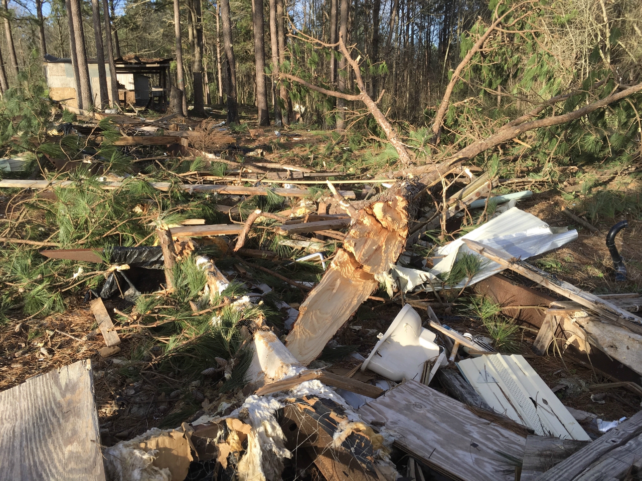
.Choctaw County, AL Tornado...

Rating:                 EF-2
Estimated Peak Wind:    115-120 mph
Path Length /statute/:  15 miles
Path Width /maximum/:   800 yards
Fatalities:             0
Injuries:               4

Start Date:             01 21 2017
Start Time:             5:14 am CST
Start Location:         2.8 miles southeast of Gilbertown, AL
Start Lat/Lon:          31.847599, -88.290451

End Date:               01 21 2017
End Time:               5:29 am CST
End Location:           15 miles northeast of Gilbertown, AL
End Lat/Lon:            31.99628, -88.10702

Survey summary: The tornado first touched down on Clark Road and
continued 15 miles to the northeast to the Choctaw and Marengo County
line. 4 homes were destroyed, including 2 mobile homes. 2 other mobile homes were destroyed by downed trees. Another 18 structures experienced varying degrees of damage, some of which included major roof damage or roof loss. The most significant damage was located on Chapel Hill Road, Wimberly Road, and Pleasant Hill Road.

We would like to thank Choctaw County EMA and the people of Choctaw
County for their time and assistance with this survey.


EF Scale: The Enhanced Fujita Scale classifies tornadoes into the following categories.

EF0...Weak......65 to 85 mph
EF1...Weak......86 to 110 mph
EF2...Strong....111 to 135 mph
EF3...Strong....136 to 165 mph
EF4...Violent...166 to 200 mph
EF5...Violent...>200 mph

Note: The information in this statement is preliminary and subject to change pending final review of the event and publication in NWS Storm Data.


Acknowledgements: Page created by Ray Ball (ITO). Page updated by Morgan Barry (Forecaster).

LAST UPDATED: December 2017