
The National Weather Service in partnership with the Alabama Emergency Management Agency will observe Alabama Winter Weather Awareness Week during the week of November 12-17, 2023.
Winter Weather Awareness Week is intended to draw attention to winter weather hazards including ice, snow, and extreme cold. While the frequency of extreme winter weather events is low in southern Alabama, winter weather can cause death, injury, and property damage.
Preparation is key to lessening the dangers and hazards associated with winter weather.

Jump to - Winter Weather Hazards, Safety & Preparedness, Products & Criteria, Significant Events or Additional Information sections.
Winter Weather Precipitation Terminology
Alabama receives a variety of winter precipitation, even across the southern part of the state. A few degrees can mean the difference between a forecast with snow or a forecast with ice!
Snow
Frozen precipitation that falls through a deep below-freezing atmospheric layer will often reach the ground in the form of soft, white flakes.
Sleet
Frozen precipitation that falls through a shallow layer of warm air (above freezing) will partially melt. It will re-freeze into ice pellets as it re-enters a layer of air that is below freezing. Sleet usually bounces when it hits the surface and does not stick to objects. However, sleet can accumulate like snow and cause hazardous travel conditions.
Freezing Rain
This occurs when frozen precipitation completely melts into rain as it falls through a deep layer of warm air (above freezing). As the rain re-enters the shallow layer of cold air near the surface, it will re-freeze on contact as it reaches the surface. Freezing rain will create a coating of ice on any object it comes into contact with.

Accumulation of snow, sleet, or freezing rain can create hazardous travel conditions. Sleet and freezing rain are VERY DANGEROUS, as the ice creates slick spots on roadways, causing motorists to quickly lose control of their vehicles. Bridges, overpasses, and elevated surfaces are especially susceptible to icing. The weight of accumulating ice can quickly down trees and power lines.
Other Winter Terminology
Frost
Frost is the formation of thin ice crystals on the ground (or other surfaces) in the form of scales, needles, feathers, or fans. Frost develops under conditions similar to dew, except the temperature falls below freezing (32°F). Frost primarily occurs as the result of radiational cooling, thus can occur at temperatures of 35 to 37°F in light wind and clear sky conditions when the wet bulb temperature is near freezing.
Black Ice
Black ice is patchy (clear) ice on roadways or other transportation surfaces that cannot easily be seen. This ice is often a deadly driving hazard that is most prevalent during early morning hours, especially after snowmelt has a chance to refreeze overnight.
Extreme Cold Terminology
Exposure to cold can cause frostbite or hypothermia and can become life-threatening. Infants and the elderly are most susceptible to the impacts of extreme cold. In the Deep South, freezing temperatures can cause severe damage to citrus fruit crops and other sensitive vegetation. Pipes may freeze and burst in poorly-insulated homes or those without heat.
Wind Chill
The combined effect of the air temperature and the wind speed on exposed skin. As wind speed increases, heat is carried away from the body at an accelerated rate, which caused body temperature to decrease. Humans and animals are both impacted by wind chill.

Calculate your windchill temperature here!
Frostbite
This is the damage to body tissue caused by extreme cold. Frostbite causes a loss of feeling and a white or pale appearance to extremities (e.g. fingers, toes, ears, or the tip of the nose). If symptoms are detected, seek medical attention immediately! A wind chill of -20°F will cause frostbite in just 30 minutes.
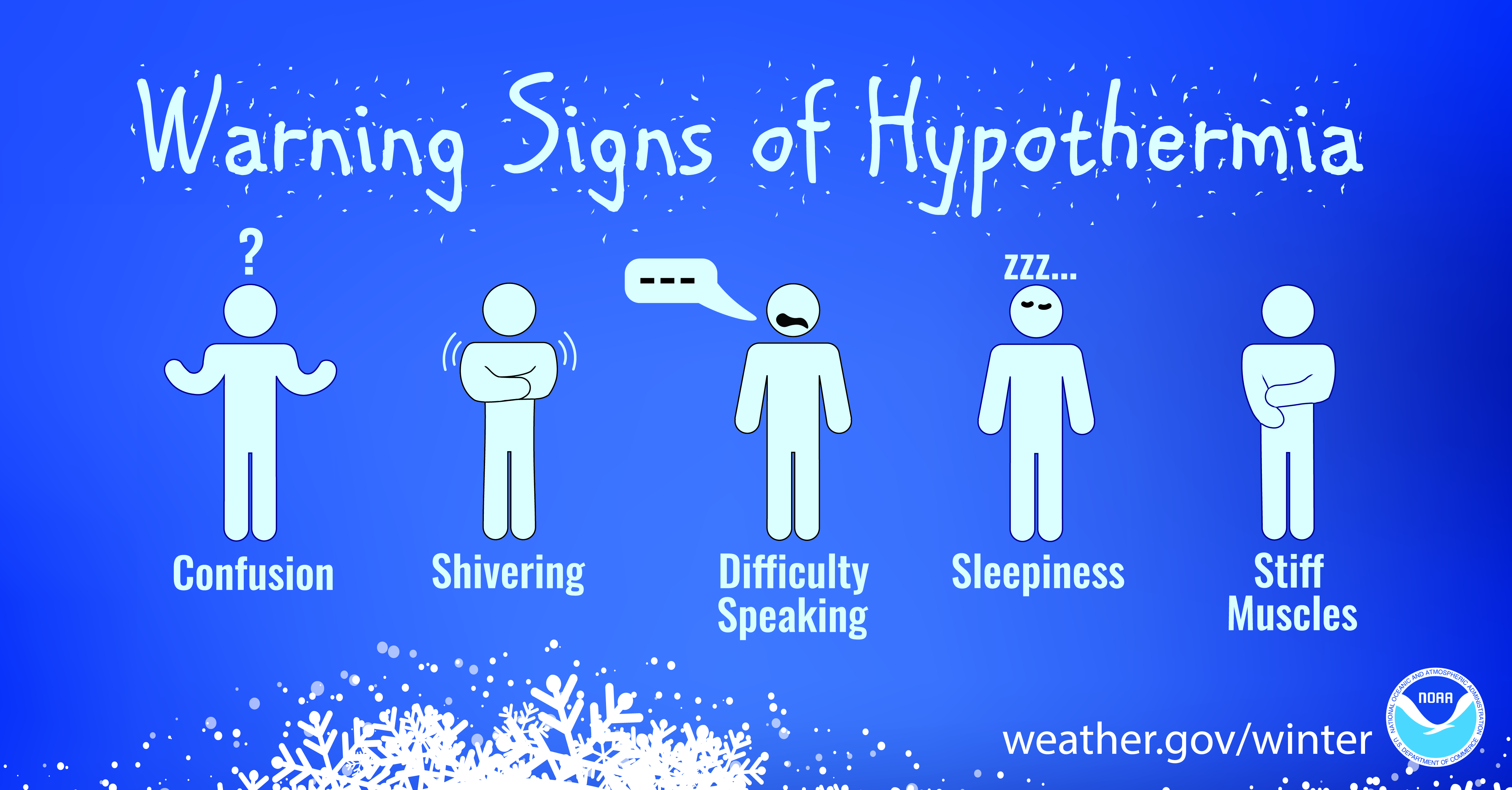
Hypothermia
A condition brought on when the body temperature drops below 95°F (which can cause death). Warning signs include uncontrollable shivering, memory loss, disorientation, incoherence, slurred speech, drowsiness, and exhaustion. Seek immediate medical care!
Winter Weather Safety and Preparedness
Regardless of the severity of the winter weather, you should be prepared in order to remain safe during winter storms.
Travel Safety and Preparedness Tips:
Check the latest weather information to avoid traveling during a winter storm! Minimize, avoid or postpone travel if at all possible. If travel is necessary during winter weather conditions, keep these tips in mind:
1. Let someone know your destination, route/alternate route, and when you expect to arrive.
If your car gets stuck in the snow, help can be sent to your route.
2.  Make sure your cellphone is fully charged.
3. Carry a winter storm emergency kit:
water (1 gallon per person per day for at least 3 days)
food (at least a 3-day supply, non-perishable)
blankets/sleeping bags
flashlight (extra batteries)
first-aid kit
cellphone charger
sand or cat litter for traction
windshield scraper and brush
shovel
tow rope
battery booster cables
4. Winterize your vehicle before traveling.
Ensure your car battery has enough power
Ensure your car is filled with antifreeze
Keep the gas tank full (a full tank will keep the fuel line from freezing)
5. Drive with extreme caution and avoid overpasses and bridges.
Cold Weather Preparedness Tips for Home and/or Work:

The primary concerns at home and work are loss of heat, power, phone service, and a shortage of supplies (if winter storm conditions last for more than a day).
1. Plan ahead and have a winter weather kit available. Suggestions:
flashlight and extra batteries
battery-powered NOAA Weather Radio or portable AM/FM radio
extra food and water (high-energy food such as dried fruit or nuts and granola bars)
extra medicine and baby items
first-aid supplies
heating fuel
fire extinguisher and smoke alarm
2. Make sure pets have plenty of food, water, and shelter during the storm.
3. Make sure pipes are properly insulated and leave cabinet doors open around pipes to ensure they receive warmth.
4. Close off unneeded rooms and place towels or rags in any cracks under the doors.
5. Let faucets drip to prevent freezing water from causing pipes to burst.
6. DO NOT use candles if the electricity goes out since these can become a fire hazard.
7. Learn how to properly use emergency heating sources (e.g. fireplace, wood stove, space heater) to prevent a fire.
Make sure the heating sources are ventilated!

For more winter weather preparedness tips and suggestions, check out these webpages:
Winter Storm and Extreme Cold Tips from FEMA
Winter Storm Preparedness Tips from the Red Cross
Emergency Kit for Pets from Ready.gov
Tips for Protecting Pets from the Cold from the Humane Society and ASPCA

Winter Weather Products and Criteria from NWS Mobile
Winter weather impacts our forecast area (covering southwest Alabama, southeast Mississippi, and northwest Florida) much differently than it does across the northern parts of the United States. Accordingly, the criteria for winter weather products vary at each National Weather Service office.
NEW! The heavy snow criteria for our region will change ahead of the 2023-2024 Winter Season. The map below breaks down the new heavy snow criteria for our local Winter Storm Watches and Warnings.

Here is a look at the wintry criteria for the NWS Mobile area...
• WATCH PRODUCTS •
WATCH = Be Alert!
Winter Storm Watch
Potential for (a 50% or greater chance of)
Snow: accumulation of 2 inches (1 inch) or more across our northernmost (southernmost) counties OR
Sleet/Ice Pellets: accumulation of 1/2 inch or more OR
Freezing Rain/Drizzle: accumulation of 1/4 inch or more of ice OR
Combination of these
in the next 12-48 hours.
Wind Chill Watch
Potential for wind chill values of -10°F or lower in the next 12-48 hours.
Freeze Watch
Potential for light freezing temperatures (generally 28°F to 32°F) to pose a threat to new growth at the start and end of the growing seasons in spring and autumn (or after an extended period of unusually warm weather) within the next 24-48 hours. This product is issued to raise awareness for agricultural and gardening interests.
Hard Freeze Watch
Potential for the minimum temperature to reach 20°F or colder across the area (not just a single/isolated location) within the next 24-48 hours. This type of freeze poses a threat to exposed water pipes, farm equipment, and livestock (as well as automobile engine blocks and radiators if these temperatures persist for long periods).
• ADVISORY PRODUCTS •
ADVISORY = Take Action!
Winter Weather Advisory
Issued when
Snow: accumulation of less than 2 inches (1 inch) across our northernmost (southernmost) counties OR
Sleet/Ice Pellets: accumulation of less than 1/2 inch OR
Freezing Rain/Drizzle: accumulation of less than a 1/4 inch OR
Combination of these.
Issued up to 36 hours in advance of the event.
Wind Chill Advisory
Wind chill values of -9°F to 10°F are expected.
Frost Advisory
A frost is expected at the start and end of the growing seasons in spring and autumn within the next 12-24 hours. The product is issued to alert agricultural interests and growers to the potential of frost burn on sensitive outdoor plants.
• WARNING PRODUCTS •
WARNING = Take Action!
Winter Storm Warning
Issued when there is an 80% or greater chance of
Snow: accumulation of 2 inches (1 inch) or more across our northernmost (southernmost) counties OR
Sleet/Ice Pellets: accumulation of 1/2 inch or more is imminent OR
Combination of these.
Issued up to 36 hours in advance of the event.
Ice Storm Warning
Significant ice accumulations of 1/4 inch or more are expected.
Blizzard Warning
Sustained winds (or frequent gusts) of 35mph or greater are expected to be accompanied by falling and/or blowing snow, reducing visibility to less than 1/4 mile for 3 hours or more.
Wind Chill Warning
Wind chill values of -10°F or lower are expected.
Freeze Warning
Light freezing temperatures (generally 28°F to 32°F) are expected to pose a threat to new growth at the start and end of the growing seasons in spring and autumn (or after an extended period of unusually warm weather) within the next 24 hours.
Hard Freeze Warning
The minimum temperature is expected to reach 20°F or colder across the area (not just a single/isolated location) within the next 24 hours.
1996 - December 18 - Central Gulf Coast Heavy Snow Event
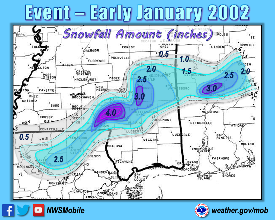
2002 - New Year Snow Event
The year began with a rare event over Southeast Mississippi and Southwest Alabama
2006 - December 5 - Gulf Coast Hard Freeze
2008 - January 19 - Rare Snow Storm
2014 - January 28-29 - Ice Storm Across the Deep South

2017 - December 8-9 - Rare North Central Gulf Coast Snow Event
2018 - January 16-17 - Deep South Wintry Weather
Additional Winter Weather Information
NEW! NWS Winter Storm Warning for Heavy Snow Criteria
NWS Weather-Ready Nation #WinterSafety Campaign
LOCAL ROAD CONDITIONS
Alabama Road Conditions and Webcams
Florida Road Conditions and Webcams
Mississippi Road Conditions
OUTLOOKS and FORECASTS
NWS WPC Winter Storm Severity Index (WSSI)
NWS WPC Winter Weather Outlooks and Forecasts
NOAA NCEI Snow and Ice Products
Red Cross Winter Storm Safety
Check out the Winter Weather Awareness Pages for the state of Alabama:
LAST UPDATED: October 2023


 Follow us on YouTube