
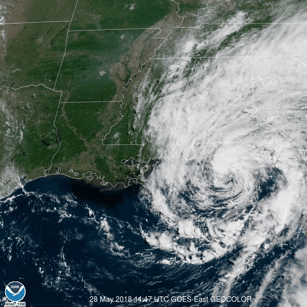
Tropical Storm Alberto (re-analyzed to a tropical storm from its initial subtropical storm categorization) was the first named storm of the 2018 Atlantic Hurricane Season. Alberto was the first of three storms to impact the NWS Mobile/Pensacola county warning area during the active 2018 season.
Alberto formed and made landfall in late May, prior to the start of the typical designated or typical hurricane season for the Atlantic Basin which runs from June 1st through November 30th each year. Pre-season storms like Alberto are not uncommon - in fact, pre-season storms occurred in 2015 (Ana in May), 2016 (Alex in January, Bonnie in May) and 2017 (Arlene in April).
More information will be added in the coming months...
Summary of all Local Storm Reports (LSRs) across the area and LSRs across the region during Tropical Storm Alberto.
Below are some of the regional impacts...
Jump to - Rainfall, Wind, Storm Surge, Tornado, Post-Tropical Cyclone Report, or Additional Information sections.
 Due to where Tropical Storm Alberto made landfall - just east of our county warning area near Laguna Beach, FL - the axis of heaviest rainfall set-up across the eastern half of our county warning area. Meanwhile, locations further to the west of landfall generally received 1" or less of storm total rainfall during Alberto. The graphic to the right, courtesy of NWS Birmingham, shows the drastic gradient in 24-hour storm total rainfall amounts observed closer to the location of landfall versus further to the west (where little if any rain fell in some communities).
The highest storm total rainfall amount of 5.57" was observed near Niceville in Okaloosa County, FL with numerous reports of 4+ inches. The axis of 3-5+" of heavy rain extended north into Covington, Escambia, Conecuh, Crenshaw, Butler, and the far eastern portions of Wilcox and Monroe Counties in Alabama.
Heavy rainfall from the bands of Tropical Storm Alberto led to standing water and flooding in some areas with road closures across parts of Covington (Onycha community) and Butler Counties (Honoraville community).
The combination of saturated soils and gusty wind resulted in several reports of downed trees and power lines, especially across Butler County in AL.
The highest winds observed during Tropical Storm Alberto occurred at the coast with gusts up to 41 mph at Destin, FL and gusts up to 38 mph at the WeatherFlow station in Pensacola Bay.
A list of land and marine wind gusts (converted to mph) can be found in the table below.

STORM SURGE & COASTAL FLOODING
Official NOAA/NOS/CO-OPS tide gauges were used to measure the maximum storm surge and storm tide across the area during Tropical Storm Alberto. Two of the time series plots from the NOAA/NOS/CO-OPS tide gauges across coastal Alabama and northwest Florida can be viewed below.
Wave run-up resulted in flooding along Bienville Blvd on the west end of Dauphin Island (Mobile County) during Tropical Storm Alberto. Splash-over was also observed by one of our forecasters along the Causeway over Mobile Bay, but levels were not high enough for a Coastal Flood Advisory.


POST TROPICAL CYCLONE REPORT...SUBTROPICAL STORM ALBERTO
NATIONAL WEATHER SERVICE MOBILE AL
352 PM CDT FRI JUN 1 2018

NOTE: THE DATA SHOWN HERE ARE PRELIMINARY....AND SUBJECT TO UPDATES
AND CORRECTIONS AS APPROPRIATE.

THIS REPORT INCLUDES EVENTS OCCURRING WHEN WATCHES AND/OR WARNINGS
WERE IN EFFECT...OR WHEN SIGNIFICANT FLOODING ASSOCIATED WITH ALBERTO
OR ITS REMNANTS WAS AFFECTING THE AREA.

COUNTIES INCLUDED...BALDWIN...BUTLER...COVINGTON...CRENSHAW...
ESCAMBIA AL...ESCAMBIA FL...MOBILE...MONROE...OKALOOSA...
SANTA ROSA


A. LOWEST SEA LEVEL PRESSURE/MAXIMUM SUSTAINED WINDS AND PEAK GUSTS
---------------------------------------------------------------------
METAR OBSERVATIONS...
NOTE: ANEMOMETER HEIGHT IS 10 METERS AND WIND AVERAGING IS 2 MINUTES
---------------------------------------------------------------------
LOCATION  ID    MIN    DATE/     MAX      DATE/     PEAK    DATE/
LAT  LON        PRES   TIME      SUST     TIME      GUST    TIME
DEG DECIMAL     (MB)   (UTC)     (KT)     (UTC)     (KT)    (UTC)
---------------------------------------------------------------------
KDTS-DESTIN
30.40 -86.47    997.0 28/2053   330/023  28/2014   350/036 28/2005

KCEW-CRESTVIEW
30.79 -86.52    996.6 29/0003   310/020  29/0014   310/030 29/0012

K0J4-FLORALA
31.04 -86.31    996.7 29/0058   200/020  29/0309   200/029 29/0309

K79J-ANDALUSIA
31.32 -86.41    996.6 29/0356   360/016  29/0015   360/026 28/2335

KPNS-PENSACOLA REGIONAL
30.47 -87.20   1001.4 28/2130   340/019  28/2128   320/029 28/2124

KMOB-MOBILE REGIONAL
30.67 -88.24   1004.1 28/2256   350/020  28/1856   360/024 28/1856

KBFM-MOBILE BROOKLEY
30.64 -88.07   1003.9 28/2153   330/021  28/2005   330/025 28/1910

KPRN-GREENVILLE
31.84 -86.61    995.3 29/0556   020/019  29/0256   050/030 29/0440

REMARKS:


NON-METAR OBSERVATIONS...
NOTE: ANEMOMETER HEIGHT IN METERS AND WIND AVERAGING PERIOD IN
MINUTES INDICATED UNDER MAXIMUM SUSTAINED WIND IF KNOWN
---------------------------------------------------------------------
LOCATION  ID    MIN    DATE/     MAX      DATE/     PEAK    DATE/
LAT  LON        PRES   TIME      SUST     TIME      GUST    TIME
DEG DECIMAL     (MB)   (UTC)     (KT)     (UTC)     (KT)    (UTC)
---------------------------------------------------------------------
XCBS-CRYSTAL BEACH (DESTIN)
30.39 -86.41                  I 360/016  28/1708   010/030 28/1703
                                 10
REMARKS:


B. MARINE OBSERVATIONS...
NOTE: ANEMOMETER HEIGHT IN METERS AND WIND AVERAGING PERIOD IN
MINUTES INDICATED UNDER MAXIMUM SUSTAINED WIND IF KNOWN
---------------------------------------------------------------------
LOCATION  ID    MIN    DATE/     MAX      DATE/     PEAK    DATE/
LAT  LON        PRES   TIME      SUST     TIME      GUST    TIME
DEG DECIMAL     (MB)   (UTC)     (KT)     (UTC)     (KT)    (UTC)
---------------------------------------------------------------------
42012-12NM SOUTH ORANGE BEACH AL
30.06  -87.55  1002.3 28/2040   999/027  28/0153   999/029 28/0000
                                   04/01

XFWB-CHOCTAWHATCHEE BAY (WEATHERFLOW)
30.40  -86.56                 I 320/026  28/2153   320/032 28/2143
                                   07/

XFPL-PENSACOLA BAY (WEATHERFLOW)
30.36  -87.21  1000.9 28/2117   300/027  28/1947   300/033 28/1947
                                   05/

XMLP-PERDIDO BAY (WEATHERFLOW)
30.30  -87.51  1001.4 28/2022   340/023  28/2057   340/032 28/2052
                                   05/

MLBA1-MIDDLE BAY LIGHT
30.43  -88.01  1002.7 28/2123   020/033  28/2353
                                   14/01

DPIA1-DAUPHIN ISLAND AL
30.25  -88.08  1003.4 28/2300   350/021  28/1700   360/024 28/1500
                                   14/08

REMARKS:


C. STORM TOTAL RAINFALL FROM 1200 UTC MAY 28 UNTIL 1200 UTC MAY 29
---------------------------------------------------------------------
CITY/TOWN                    COUNTY               ID         RAINFALL
LAT LON                                                       (IN)
DEG DECIMAL
---------------------------------------------------------------------
2 ENE NICEVILLE              OKALOOSA            FL-OK-20      5.57
30.50  -86.46

1 N SANFORD                  COVINGTON           K79J          4.84
31.31  -86.39

2 SE NICEVILLE               OKALOOSA            FL-OK-3       4.82
30.50  -86.46

1 NE DIXIE                   ESCAMBIA            TT360         4.68
31.14  -86.72

4 SE DEERLAND                OKALOOSA            F0856         4.59
30.71  -86.40

PLEASANT HOME                COVINGTON                         4.50
31.15  -86.62

RED LEVEL                    COVINGTON                         4.44
31.40  -86.61

5 ENE FALCO                  COVINGTON           OPNA1         4.42
31.04  -86.62

9 N GREENVILLE               BUTLER                            4.30
31.96  -86.59

6019 ENE CRESTVIEW           OKALOOSA            KCEW          4.19
30.76  -86.57

NICEVILLE                    OKALOOSA            FL-OK-37      4.04
30.50  -86.46

GEORGIANA                    BUTLER                            4.00
31.63  -86.74

BRATT                        ESCAMBIA                          3.96
30.96  -87.43

VALPARAISO                   OKALOOSA            FL-OK-2       3.42
30.51  -86.50

FLORALA                      COVINGTON           KOJ4          3.28
31.00  -86.33

2 W RUTLEDGE                 CRENSHAW            E2927         2.42
31.73  -86.35

2 ESE EXCEL                  MONROE              AL-MN-4       2.40
31.42  -87.35

REMARKS: RAINFALL REPORTS ARE FROM A COMBINATION OF ASOS, COCORAHS,
OTHER MESONETS, TRAINED SPOTTERS, AND EMERGENCY MANAGEMENT.


D. INLAND FLOODING...
---------------------------------------------------------------------
COVINGTON...FLOODING WAS REPORTED ON DRY CREEK ROAD IN ONYCHA. SOME
CITY STREETS IN ANDALUSIA WERE IMPASSABLE DUE TO THE HEAVY RAIN.

BUTLER...A ROAD WAS CLOSED DUE TO FLOODING FROM THE RAIN BANDS OF
ALBERTO 4 MILES NORTHWEST OF HONORAVILLE.


E. MAXIMUM STORM SURGE AND STORM TIDE...
OFFICIAL TIDE GAUGES NOTED WITH LEADING G
---------------------------------------------------------------------
COUNTY           CITY/TOWN        SURGE   TIDE   DATE/   BEACH
                 OR LOCATION      (FT)    (FT)   TIME    EROSION
---------------------------------------------------------------------
MOBILE         G DAUPHIN ISLAND   9999.00   1.31  28/1324    MINOR  I

ESCAMBIA       G PENSACOLA        9999.00   1.18  28/1600  UNKNOWN  I


STORM TIDE READINGS ARE IN REFERENCE TO MEAN HIGHER HIGH WATER (MHHW)
WHICH IS USED AS AN APPROXIMATION FOR INUNDATION ABOVE NORMALLY DRY
GROUND.


F. TORNADOES...
---------------------------------------------------------------------
(DIST)CITY/TOWN              COUNTY           DATE/         EF SCALE
LAT LON (DEG DECIMAL                          TIME(UTC)    (IF KNOWN)
DESCRIPTION
---------------------------------------------------------------------


G. STORM IMPACTS BY COUNTY...
---------------------------------------------------------------------
COUNTY            DEATHS           INJURIES             EVACUATIONS
DESCRIPTION
---------------------------------------------------------------------
MOBILE               0                 0                     0

WAVE RUN-UP RESULTED IN MINOR FLOODING ON BIENVILLE BLVD ON THE FAR
WEST END OF DAUPHIN ISLAND.

COVINGTON            0                 0                     0

THE COMBINATION OF SATURATED SOILS AND GUSTY WINDS RESULTED IN THE
DOWNING OF MULTIPLE TREES ACROSS COVINGTON COUNTY.

BUTLER               0                 0                     0

THE COMBINATION OF SATURATED SOILS AND GUSTY WINDS RESULTED IN THE
DOWNING OF MULTIPLE TREES AND POWER LINES IN BUTLER COUNTY.

$$

Legend:
I-Incomplete Data
E-Estimated

JASON BEAMAN
Link to the PSH product online
NHC Advisory Archive
WPC Archive
NHC Tropical Cyclone Report - Tropical Storm Alberto
NOAA Tides & Currents - Highest Storm Water Levels (not available yet)
NOAA Tides & Currents - Archived Storm QuickLooks
Acknowledgements: Page created by Morgan Barry (forecaster).
LAST UPDATED: April 2019


 Follow us on YouTube