
Hurricane Baker - August 30, 1950
 Baker began forming as a tropical depression just east of the Leeward Islands on August 18th in the year of 1950. Early in the morning on the 19th, Baker had strengthened into a tropical storm. Baker continued to strengthen through the day on the 19th and 20th and achieved Category 1 Hurricane status on the evening of the 20th. It continued to strengthen on the 21st and briefly became a Category 2 Hurricane before passing over Antigua.
After passing over the islands, Baker weakened to a tropical storm as it moved west-northwest toward Puerto Rico. The terrain of Puerto Rice, Dominican Republic and Cuba caused Baker to continually weaken further over the next several days.
By the 27th of August, Baker resurfaced in the Yucatan Channel after traversing over the island of Cuba. Baker began to quickly redevelop and restrengthen as it turned north toward the Gulf of Mexico. By the evening of the 28th, Baker had strengthened considerably and regained Category 1 Hurricane status. Baker continued to strengthen through the overnight hours and was again a Category 2 Hurricane by midday on the 29th of August. A hand-drawn analysis of Hurricane Baker as it approached the northern Gulf Coast on August 30th near its peak intensity can be viewed in the top image on the right (courtesy of NOAA AOML/HRD).
Baker maintained Category 2 status until reaching the cooler shelf waters south of Alabama
where it began to weaken slightly. Baker made its first landfall late in the evening on August 30th along the Fort Morgan Peninsula. One hour later, Baker moved up Mobile Bay and made a second landfall near Spanish Fort and Daphne, AL as a Category 1 Hurricane. Another hand-drawn analysis of Hurricane Baker near the time of its first landfall late on 30th can be viewed in the bottom image on the right (courtesy of NOAA AOML/HRD).
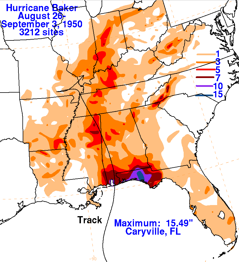
Peak gusts exceeded 100mph across much of the southern Alabama and northwest Florida coastline. It was estimated that 8-10 inches of rain fell across the area during Hurricane Baker with higher amounts on the eastern edge of the path. A visualization of this rainfall can be viewed in the storm total rainfall graphic below (courtesy of NOAA WPC). The resultant heavy rainfall across the Florida panhandle and southern Alabama resulted significant crop damage.
Additional Information
WPC Archive
Monthly Weather Review - Atlantic Hurricane Season of 1950
NOAA Digital Coast - Hurricane Baker Track
Acknowledgements: Page created by Morgan Barry (forecaster).
LAST UPDATED: August 2018


 Follow us on YouTube