
Hurricane Frederic
September 12, 1979
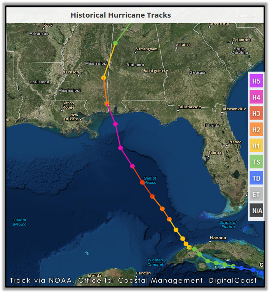
Frederic formed on August 29 as a tropical depression over the far eastern Atlantic and became a hurricane on September 10 over the
Gulf of Mexico.
Hurricane Frederic strengthened to a Category 4 hurricane over the
central Gulf of Mexico with maximum sustained winds near 132 mph.
On Wednesday, September 12, 1979 at 5am, the NWS issued
Hurricane Warnings from Panama City, FL to Grand Isle, LA. Frederic
continued to strengthen with highest winds estimated at 130mph and
central pressure of 28.05 inches of mercury. Frederic continued
moving northwest with a slightly increased forward speed at 12mph
located about 220 miles south of the Alabama Coast. Hurricane
Frederic was expected to produce a storm surge of 10-15 feet above
normal in the area where the center made landfall.
By 11am on September 12, Frederic was located 175 miles south
of Pensacola moving north-northwest at 12-15 mph. The diameter of
the hurricane eye was reported to be about 10 miles. Reports from hurricane hunter reconnaissance aircraft and coastal weather radar networks indicated the eye of Frederic would cross the coast between Gulfport, MS and Pensacola, FL. Evacuation of the Gulf Coast was nearing completion at that time.
By 5pm on September 12, the center of Hurricane Frederic was about 80 miles south of Gulf Shores, AL moving north at 15 mph.


Conditions began to rapidly deteriorate during the afternoon of September 12 as Frederic approached the Alabama Gulf Coast. Hurricane Frederic approached the coast with a forward speed of 15mph. The eye of the Frederic measured 50 miles in diameter east to west and 40 miles north to south. In the opinion of some weather forecasters at the time, Frederic had the largest storm center they had ever recorded.
Photo courtesy of NOAA, Office for Coastal Management, DigitalCoast
Shortly before 10pm on September 12, the northern eyewall of Frederic move ashore on Dauphin Island, AL. As the eye moved inland, it decreased in size to about 15 miles in diameter. The storm center crossed over the western end of Dauphin Island at 10pm. An automated wind gust recorder (located at the top of the Dauphin Island Bridge), recorded a peak wind gust of 145mph around 940pm. At landfall, Frederic was a Category 4 on the Saffir-Simpson Hurricane Intensity Scale, raking the Mobile Bay area with winds gusting from 100-145 mph for several hours on the evening of September 12 through the early morning of September 13. Hurricane wind gusts were experienced as far inland as Choctaw County, AL during the early morning hours of September 13.

The damage cost from Frederic was $2.3 billion. Five deaths were directly attributable to the storm. A storm surge of 12-15 feet on the Gulf beaches and 8-10 feet in northern Mobile Bay destroyed numerous coastal buildings. Storm surge damage was documented for 80 miles along the coast.
The winds from Hurricane Frederic damaged or destroyed many homes and businesses. Many homes and businesses well inland suffered severe damage when large pine trees fell onto them or the roof structures failed. Along with peak wind gusts of 145mph at the Dauphin Island Bridge, wind gusts of 97mph from the east were recorded at Mobile Regional Airport at 1107pm. At midnight, Mobile County Civil Defense also reported measured wind gusts at 97mph, along with massive damage in Mobile and surrounding areas. At midnight, wind gusts from the north at 98mph were reported by Biloxi Civil Defense with north winds gusting to 127mph at Ingalls Shipbuilding in Pascagoula, MS.
At 2am on Thursday, September 13, the NWS issued an intermediate advisory reporting the center of Hurricane Frederic had passed just west of Mobile and the hurricane force winds began to slowly subside in the Mobile area as Frederic continued to move north along the Alabama/Mississippi border. Extensive reports of damage in the Mobile metropolitan area were beginning to come in to the NWS. After moving inland from the coast, the hurricane moved north and then northeast, increasing its forward speed to 23mph. It did not lose hurricane intensity until it was in the vicinity of Meridian, MS at about 7am!
By 8am on September 13, Frederic was downgraded to a tropical storm. Frederic maintained that intensity as it moved north through Mississippi, crossing back into Alabama west of Tuscaloosa. Late that afternoon, Frederic was further downgraded to a tropical depression as it moved north through Alabama.

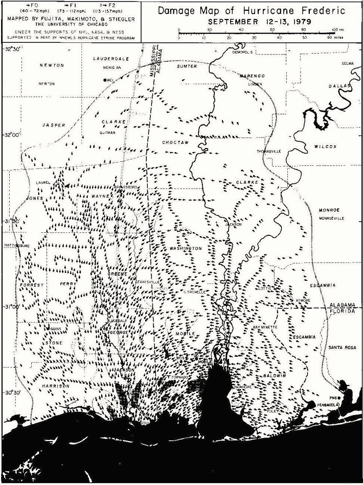
Numerous large swaths of significant wind damage were documented in the days immediately following the landfall of Frederic. Fallen trees were a significant impact to residents, bringing down thousands of power lines and blocking roads for several days. Some areas of Mobile County experienced electric power outages for 5 weeks.
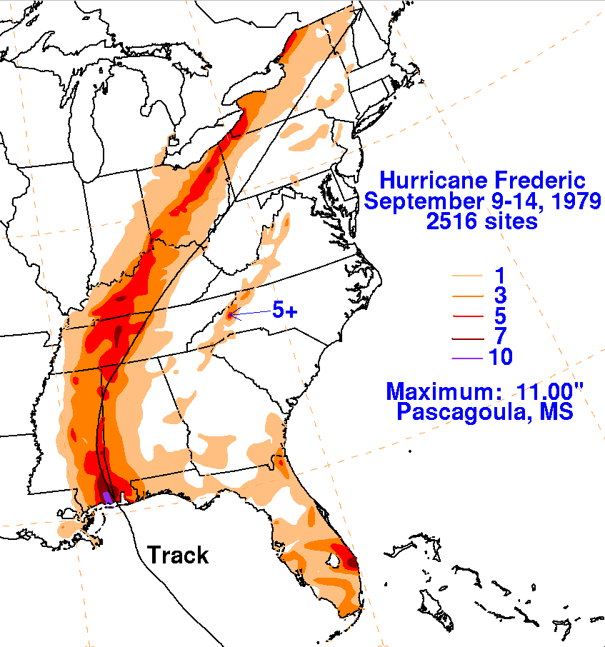
Frederic moved north along the Alabama/Mississippi border dropping 3-11 inches of rain along its path. The highest rainfall total of 11 inches was reported in Pascagoula, MS.
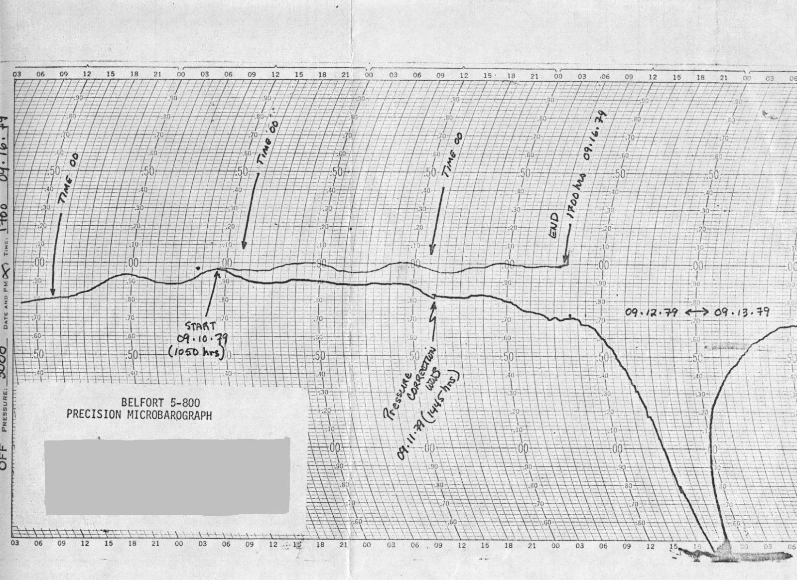
Microbaragraph trace from Dauphin Island Sea Lab (NOAA)
The lowest barometric pressure recorded in Frederic by NOAA Hurricane Hunter reconnaissance aircraft was 943mb (27.85 inches of mercury). Mobile Regional Airport set an all-time recorded low barometric pressure at 1040pm on September 12 of 28.38 inches of mercury. Dauphin Island Sea Lab reported a minimum pressure of 943mb (27.85 inches of mercury).
Over 500,000 people evacuated from the Central Gulf Coast Region ahead of Hurricane Frederic - the largest evacuation along the Gulf Coast up to that time. Frederic was the first hurricane to directly strike Mobile since 1932. Before Frederic, the last hurricane with Category 3 winds to directly strike the Alabama Gulf Coast occurred in 1916. There was also the 1926 “Great Miami” Hurricane that weakened to a Category 2 storm as it passed over Fort Morgan and Dauphin Island, AL.

Hurricane Frederic...Picking Up The Pieces - YouTube video from National Archives and Records Administration/PublicResource.Org
Imagery
NOAA Digital Coast - Hurricane Frederic Track
More Information (Technical Papers and Assessments)
Hurricane Reaseach Division (HRD) Aircraft Missions into Frederic
Coastal Weather Research Center - Hurricane Frederic (University of South Alabama)
Monthly Weather Review - Atlantic Hurricane Season of 1979
WPC Archive
NWS Local Write-Ups and Webpages:
NWS Birmingham
Acknowledgements: Page created by Morgan Barry (Forecaster), Jason Beaman (Warning Coordination Meteorologist) and Don Shepherd (Senior Forecaster, Tropical Focal Point).
LAST UPDATED: September 2022


 Follow us on YouTube