
Hurricane Isaac
August 28, 2012
 Tropical Depression #9 formed east of the Lesser Antilles on the morning of August 21, 2012. By the afternoon hours on the 21st, Isaac had strengthened into a tropical storm. Isaac tracked westward through the eastern Caribbean Sea, into the Florida Straits and then into the southeast Gulf of Mexico through the early hours of August 27th, while maintaining high end tropical storm strength. Tropical Storm Isaac then tracked northwest across the eastern Gulf of Mexico late on the 27th and early on the 28th.
On the afternoon of August 28th, Isaac strengthened to a hurricane with winds of 80 mph just off the southeast Louisiana coast (approximately 75 miles south-southeast of the mouth of the Mississippi River). At 6:45pm on August 28th, Hurricane Isaac made a brief landfall along the coast of southeast Louisiana in Plaquemines Parish. Maximum sustained winds were 80mph during landfall.
Isaac did not remain over land for long as the hurricane was back over water again by 9pm that same evening. Hurricane Isaac made a 2nd landfall along the coast of southeast Louisiana (just west of Port Fourchon) around 2:15am on August 29th, again with maximum sustained winds of 80mph. The radar loop above shows the progression of Hurricane Isaac (courtesy of University of Alabama in Huntsville).
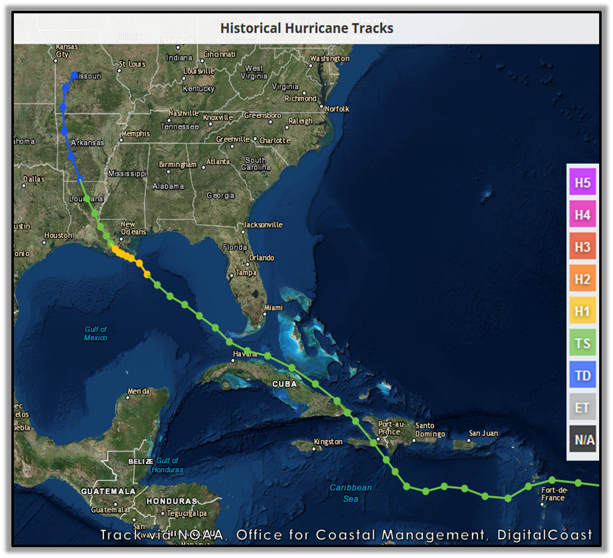
Photo courtesy of NOAA, Office for Coastal Management, DigitalCoast
As the inner core of Isaac moved very slowly north across central Louisiana over the course of August 29th and 30th, the outer bands of the hurricane lifted northward across portions of southeast Mississippi, southwest Alabama, and the western Florida panhandle. The slow movement of Isaac resulted in prolonged wind, coastal flooding and flash flooding impacts across the entire region.
Overall the region fared well with regard to impacts from Hurricane Isaac. Heavy flooding rains, especially over southeast Mississippi; and minor to moderate coastal flooding and erosion were the primary problems. No injuries were reported in association with Hurricane Isaac across the area. One indirect death was reported in Escambia County, FL when a man drowned in the increasingly rough surf while attempting to ride a JetSki on August 27th as Isaac began moving north across the Gulf.
Hurricane Isaac did not directly hit our area, but significant impacts were felt across the region. The majority of this document will focus on the impacts from flooding across southern Alabama and southern Mississippi. Below are some of the regional impacts...
Jump to - Rainfall, Wind, Storm Surge, Tornado, Post-Tropical Cyclone Report, or Additional Information sections.

Photo courtesy of NASA Earth Observatory
Although Isaac weakened in intensity as it moved inland, the movement of the storm slowed to around 5 mph. This slow down resulted in prolonged excessive rainfall and resultant flooding across southwest Alabama and southeast Mississippi. The heaviest, most persistent rainfall occurred on the evening of August 29th. Radar storm total estimates of 10-20 inches of rain fell over parts of the region, especially over southeast Mississippi. Radar estimates from KMOB radar can be seen in the image to the right. The highest observed regional rainfall totals were in southeast Mississippi - Latonia, MS with 17.60 inches and Buckatunna, MS with 15.39 inches.
This widespread heavy rainfall resulted in catastrophic flash flooding over much of the region, especially across southeast Mississippi. Many roadways became flooded and many across southeast Mississippi even washed out (as seen in the images below). Water covered Highway 613 in George County, Highway 57 in Greene County an several roads across Stone County in southeast Mississippi. Many buildings across that same area became inundated, which led to numerous water rescues of trapped individuals.
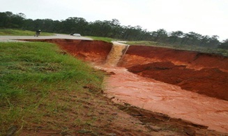
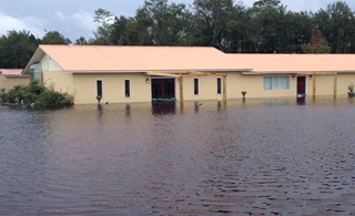
Washed out road near Leakesville, MS Flooding near Leakesville, MS
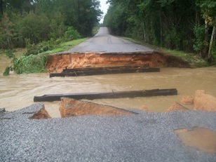
Washed out road near Lucedale, MS
Impacts from the wind were rather minimal across the region, but there were some scattered, brief power outages and trees down. The strongest winds occurred along the immediate coastline where the onshore flow produced the highest wind gusts. The highest wind gust observed during Isaac was 60mph at 910am on the east end of Dauphin Island, AL. Elsewhere, along the Alabama and western Florida panhandle coastline, peak wind gusts of 40-50mph were common from late afternoon on Aug 28th through the afternoon hours on Aug 29th. Wind to 60mph damaged a grocery store roof in McHenry, MS (Stone County) along with several other buildings across the area. Some of the higher wind gusts reported across the area are as follows:
| Location | Wind Gust (mph) |
| Dauphin Island | 60 |
| Brookley Field | 51 |
| Mobile Regional Airport | 47 |
| Pensacola International Airport | 47 |
| Milton | 44 |
| Destin | 40 |

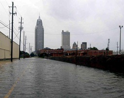
Alabama Port Downtown Mobile
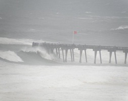
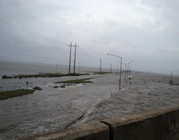
Pensacola Beach Pier Causeway over Mobile Bay
3 brief EF-0 tornadoes occurred across the area as a result of Hurricane Isaac. There was an EF0 in Monroe and Choctaw Counties in Alabama and 1 EF0 in Greene County in Mississippi. Only light debris and a few downed and snapped trees were reported with these brief tornadoes with no significant damage across the area.
POST TROPICAL CYCLONE REPORT...HURRICANE ISAAC...REMOVED KNPA WIND DATA
NATIONAL WEATHER SERVICE MOBILE AL
355 PM CDT TUE SEP 4 2012

NOTE: THE DATA SHOWN HERE ARE PRELIMINARY....AND SUBJECT TO UPDATES
AND CORRECTIONS AS APPROPRIATE.

THIS REPORT INCLUDES EVENTS OCCURRING WHEN WATCHES AND/OR WARNINGS
WERE IN EFFECT...OR WHEN SIGNIFICANT FLOODING ASSOCIATED WITH ISAAC
OR ITS REMNANTS WAS AFFECTING THE AREA.

COUNTIES INCLUDED...BALDWIN...ESCAMBIA FL...GEORGE...MOBILE...
OKALOOSA...SANTA ROSA...STONE...WASHINGTON...GREENE...PERRY...
WAYNE

A. LOWEST SEA LEVEL PRESSURE/MAXIMUM SUSTAINED WINDS AND PEAK GUSTS
---------------------------------------------------------------------
METAR OBSERVATIONS...
NOTE: ANEMOMETER HEIGHT IS 10 METERS AND WIND AVERAGING IS 2 MINUTES
---------------------------------------------------------------------
LOCATION  ID    MIN    DATE/     MAX      DATE/     PEAK    DATE/
LAT  LON        PRES   TIME      SUST     TIME      GUST    TIME
DEG DECIMAL     (MB)   (UTC)     (KT)     (UTC)     (KT)    (UTC)
---------------------------------------------------------------------
KMOB-MOBILE REGIONAL
30.67 -88.24   1003.3 29/0856   130/027  29/2028   100/041 28/1533

KBFM-MOBILE BROOKLEY
30.64 -88.07   1003.7 28/2053   070/030  29/0249   100/044 29/0608

KJKA-GULF SHORES
30.29 -87.67   9999.0 /         130/022  30/0215   140/033 30/0055

KPNS-PENSACOLA REGIONAL
30.47 -87.20   1004.9 28/2053   110/028  28/2153   100/041 28/2026

KNDZ-MILTON NORTH
30.72 -87.02   1006.4 29/2056   170/014  30/1856   170/027 30/1830

KNSE-MILTON SOUTH
30.70 -87.02   1005.1 28/2156   120/023  28/1856   140/038 28/1625

KCEW-CRESTVIEW
30.79 -86.52   1000.0 28/0753   130/018  30/1440   120/030 29/1559

KHRT-MARY ESTHER
30.42 -86.68   1008.4 29/2043   130/012  30/1855   130/025 30/1855

KVPS-VALPARISO
30.48 -86.53   1006.8 28/1637   180/023  30/1857   180/039 28/1634

KDTS-DESTIN
30.40 -86.47   1008.7 29/2053   140/012  30/1953   120/035 28/1753

K79J-ANDALUSIA
31.32 -86.41   1020.0 01/0056   150/003  01/0056

REMARKS:


NON-METAR OBSERVATIONS...
NOTE: ANEMOMETER HEIGHT IN METERS AND WIND AVERAGING PERIOD IN
MINUTES INDICATED UNDER MAXIMUM SUSTAINED WIND IF KNOWN
---------------------------------------------------------------------
LOCATION  ID    MIN    DATE/     MAX      DATE/     PEAK    DATE/
LAT  LON        PRES   TIME      SUST     TIME      GUST    TIME
DEG DECIMAL     (MB)   (UTC)     (KT)     (UTC)     (KT)    (UTC)
---------------------------------------------------------------------


B. MARINE OBSERVATIONS...
NOTE: ANEMOMETER HEIGHT IN METERS AND WIND AVERAGING PERIOD IN
MINUTES INDICATED UNDER MAXIMUM SUSTAINED WIND IF KNOWN
---------------------------------------------------------------------
LOCATION  ID    MIN    DATE/     MAX      DATE/     PEAK    DATE/
LAT  LON        PRES   TIME      SUST     TIME      GUST    TIME
DEG DECIMAL     (MB)   (UTC)     (KT)     (UTC)     (KT)    (UTC)
---------------------------------------------------------------------
DPIA1-DAUPHIN ISLAND
30.24  -88.07                   120/042  29/1410   140/052 28/2000
                                   13.5

REMARKS:


C. STORM TOTAL RAINFALL FROM 1200 UTC AUG 28 UNTIL 1200 UTC AUG 31
---------------------------------------------------------------------
CITY/TOWN                    COUNTY               ID         RAINFALL
LAT LON                                                       (IN)
DEG DECIMAL
---------------------------------------------------------------------
BUCKATUNNA                   WAYNE               BKAM6        15.39
31.50  -88.50

GRAND BAY                    MOBILE                           13.99
30.48  -88.34

WIGGINS                      STONE                            11.69
30.86  -89.14

LEAKESVILLE                  GREENE              LEKM6        11.16
31.15  -88.55

PERKINSTON                   STONE                            10.50
30.78  -89.14

MOBILE                       MOBILE              KMOB          9.71
30.68  -88.24

WAYNESBORO                   WAYNE               WAYM6         9.42
31.67  -88.64

SEMMES                       MOBILE                            9.40
30.78  -88.26

NEW AUGUSTA                  PERRY                             8.99
31.22  -89.05

BROOKLY FIELD                MOBILE              KBFM          7.49
30.60  -88.06

CODEN                        MOBILE                            6.99
30.38  -88.24

DAUPHIN ISLAND               MOBILE              DAUA1         6.97
30.25  -88.08

FAIRHOPE                     BALDWIN                           6.72
30.52  -87.90

DAPHNE                       BALDWIN                           6.10
30.60  -87.90

MCLAIN                       GREENE                            5.77
31.10  -88.80

CRESTVIEW                    OKALOOSA            KCEW          4.64
30.79  -86.52

DESTIN                       OKALOOSA            KDTS          4.58
30.40  -86.47

EGLIN AFB                    OKALOOSA            KVPS          3.53
30.48  -86.53

PENSACOLA                    ESCAMBIA            3.8N          3.35
30.50  -87.19

PENSACOLA AIRPORT            ESCAMBIA            KPNS          2.36
30.47  -87.20

REMARKS:


D. INLAND FLOODING...
---------------------------------------------------------------------
STONE...SEVERAL ROADS CLOSED DUE TO FLOODING FROM EXCESSIVE RAINFALL
OVER THE EASTERN HALF OF THE COUNTY.

GEORGE...SEVERAL HOMES FLOODED AS WELL AS MANY ROADS IN AND AROUND
LUCEDALE.

GREENE...NUMEROUS WATER RESCUES AND ROADS FLOODED IN THE LEAKESVILLE
AREA.

---------------------------------------------------------------------

E. MAXIMUM STORM SURGE AND STORM TIDE...
OFFICIAL TIDE GAUGES NOTED WITH LEADING G
---------------------------------------------------------------------

COUNTY           CITY/TOWN        SURGE   TIDE   DATE/   BEACH
                 OR LOCATION      (FT)    (FT)   TIME    EROSION
---------------------------------------------------------------------
BALDWIN        G WEEKS BAY         2.96   4.45  29/2154    MINOR

MOBILE         G DAUPHIN ISLAND    3.57   4.33  28/2230 MODERATE

MOBILE         G DOG RIVER         3.64   5.27  29/0448    MINOR

MOBILE         G FOWL RIVER        3.92   5.20  29/0448    MINOR

MOBILE         G CHICKASAW CREEK   4.28   5.14  29/2254    MINOR

MOBILE         G BAYOU LA BATRE    3.97   5.69  29/1312    MINOR

MOBILE         G USCG SECTOR MOB   4.63   5.81  29/2154    MINOR

MOBILE         G MOBILE STATE DO   3.84   5.30  29/1854    MINOR

ESCAMBIA FL    G PENSACOLA         3.47   4.02  28/2106 MODERATE


REMARKS:


F. TORNADOES...
---------------------------------------------------------------------
(DIST)CITY/TOWN              COUNTY           DATE/         EF SCALE
LAT LON (DEG DECIMAL                          TIME(UTC)    (IF KNOWN)
DESCRIPTION
---------------------------------------------------------------------
2 NE OLD TEXAS               MONROE           30/0025          EF0
31.79    -86.98

EMERGENCY MANAGEMENT REPORTS POSSIBLE TORNADO IN NORTHEASTERN PART
OF THE COUNTY.

3 SE SAND HILL               GREENE           30/0240          EF0
31.31   -88.73

DEBRIS FROM POSSIBLE TORNADO ON BRADLEY ROAD NEAR SAND HILL.

1 E TOXEY                    CHOCTAW          30/1558          EF0
31.91   -88.29

NATIONAL WEATHER SERVICE EMPLOYEE REPORTS DOWNED AND SNAPPED TREES
DUE TO A TORNADO NEAR THE TOWN OF TOXEY.


G. STORM IMPACTS BY COUNTY...
---------------------------------------------------------------------

COUNTY            DEATHS           INJURIES             EVACUATIONS
DESCRIPTION
---------------------------------------------------------------------
MOBILE               0                 0                     0

STORM SURGE...INUNDATION WATER LEVELS OF 1 TO 3 FEET WERE REPORTED
AT MANY OF THE COASTAL AREAS...ESPECIALLY AT THE TIMES OF
ASTRONOMICAL HIGH TIDES ON BOTH AUG 28TH AND AUG 29TH. NUMEROUS
COASTAL ROADWAYS WERE FLOODED...ALONG WITH OTHER WATERFRONT
PROPERTY. SOME OF THE ROADWAYS INCLUDE...WATER STREET (AND VARIOUS
OTHER STREETS) IN DOWNTOWN MOBILE...DAUPHIN ISLAND PARKWAY AT THE
DOG RIVER BRIDGE...BIENVILLE BOULEVARD ON THE WEST END OF DAUPHIN
ISLAND...THE HIGHWAY 90 CAUSEWAY OVER NORTHERN MOBILE BAY...AS WELL
AS LOCATIONS AROUND ALABAMA PORT. ALABAMA GOVERNOR ORDERED
EVACUATIONS OF ZONES 1 AND 2 IN COASTAL MOBILE COUNTY.

BALDWIN              0                 0

STORM SURGE...WATER LEVELS OF 1 TO 3 FEET ALONG AREA BEACHES...ALONG
WITH ROUGH SURF WHICH RESULTED IN MINOR TO MODERATE BEACH EROSION.
SOME ROADWAYS ON FORT MORGAN WERE FLOODED. ALABAMA GOVERNOR ORDERED
THE EVACUATION OF ZONES 1 AND 2 IN COASTAL AREAS OF BALDWIN COUNTY.

ESCAMBIA FL          1                 0                     0

STORM SURGE...WATER LEVELS OF 1 TO 3 FEET FLOODED SOME ROADWAYS NEAR
THE BEACHES. VERY ROUGH SURF RESULTED IN MINOR TO MODERATE BEACH
EROSION. ONE DEATH OCCURRED WHEN A MAN APPARENTLY DROWNED WHILE
ATTEMPTING TO RIDE A JETSKI IN THE BUILDING SURF AS TROPICAL STORM
ISAAC BEGAN MOVING NORTH ACROSS THE GULF ON MONDAY AUGUST 27TH.

SANTA ROSA           0                 0                     0

STORM SURGE...WATER LEVELS OF 1 TO 3 FEET ALONG AREA BEACHES...ALONG
WITH ROUGH SURF WHICH RESULTED IN MINOR TO MODERATE BEACH EROSION.
SOME IMMEDIATE COASTAL ROADWAYS AND LOW LYING AREAS WERE FLOODED.

OKALOOSA             0                 0                     0

STORM SURGE...WATER LEVELS OF 1 TO 2 FEET ALONG AREA
BEACHES...COMBINED WITH ROUGH SURF...RESULTED IN MINOR BEACH
EROSION. A FEW ROADWAYS AND LOW LYING AREAS ALONG THE IMMEDIATE
COAST WERE FLOODED.

WASHINGTON           0                 0                     0

EXCESSIVE RAINFALL...RADAR ESTIMATES OF UP TO 5 TO 7 INCHES OF STORM
TOTAL RAINFALL FELL ACROSS WESTERN PORTIONS OF THE COUNTY.

STONE                0                 0                     0

EXCESSIVE RAINFALL AND FLASH FLOODING...RADAR ESTIMATES UP TO 15 TO
20 STORM TOTAL RAINFALL OCCURRED...MOST OF WHICH FELL ON THE EVENING
OF AUGUST 29TH. STONE COUNTY EMA REPORTED SEVERAL ROADS CLOSED DUE
TO FLOOD WATERS.

GEORGE               0                 0                     0

EXCESSIVE RAINFALL AND FLASH FLOODING...RADAR ESTIMATES UP TO 15 TO
20 INCHES OF STORM TOTAL RAINFALL OCCURRED...MOST OF WHICH FELL ON
THE EVENING OF AUGUST 29TH, EMERGENCY MANAGER REPORTED SEVERAL HOMES
FLOODED AND MANY ROADS IN AND AROUND LUCEDALE.

GREENE               0                 0                     0

EXCESSIVE RAINFALL AND FLASH FLOODING...RADAR ESTIMATES UP TO 10 TO
15 INCHES OF STORM TOTAL RAINFALL OCCURRED ACROSS THE COUNTY...
PRIMARILY FALLING ON THE EVENING OF AUGUST 29TH.

PERRY                0                 0                     0

EXCESSIVE RAINFALL...RADAR ESTIMATES UP TO 10 TO 15 INCHES OF STORM
TOTAL RAINFALL OCCURRING OVER THE COUNTY...THE MAJORITY OF WHICH
FELL ON THE EVENING OF AUGUST 29TH.

WAYNE                0                 0                     0

EXCESSIVE RAINFALL...RADAR ESTIMATES UP TO 15 TO 20 INCHES OF
RAINFALL OCCURRED ACROSS THE COUNTY...PRIMARILY ON THE EVENING OF
AUGUST 29TH.

$$

LEGEND:
I-INCOMPLETE DATA
E-ESTIMATED

DON SHEPHERD
NOAA Remote Sensing Response Imagery
NHC Advisory Archive
WPC Archive
NHC Tropical Cyclone Report - Hurricane Isaac
NWS Local Write-Ups and Webpages:
NWS Jackson, MS
Acknowledgements: Page created by Joe Maniscalco. Page updated by Morgan Barry (forecaster).
LAST UPDATED: September 2017


 Follow us on YouTube