|
 The National Weather Service (NWS) Weather Forecast Office (WFO) Marquette has been a part of the daily lives of Upper Michigan residents for over 130 years. Although the mission to protect lives and property has not changed in all that time, weather forecasting in itself has changed by immeasurable degrees. This page is dedicated to the exploration of the history of WFO Marquette from the changing technology to produce and distribute the forecasts to the former locations the office has called home. Users with an internet explorer browser may obtain additional information for each image seen on this site by simply passing the mouse over the image. All users may simply click an image to open a new window with an enlarged version. The National Weather Service (NWS) Weather Forecast Office (WFO) Marquette has been a part of the daily lives of Upper Michigan residents for over 130 years. Although the mission to protect lives and property has not changed in all that time, weather forecasting in itself has changed by immeasurable degrees. This page is dedicated to the exploration of the history of WFO Marquette from the changing technology to produce and distribute the forecasts to the former locations the office has called home. Users with an internet explorer browser may obtain additional information for each image seen on this site by simply passing the mouse over the image. All users may simply click an image to open a new window with an enlarged version.
 |
|
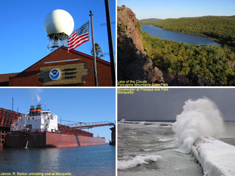
Pictures from North Central Upper Michigan near WFO Marquette..
|
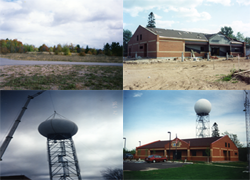
WFO Marquette currently is situated eight miles west of downtown Marquette in Negaunee Township. The area is hilly, forested, and rises abruptly by over 750 feet above the Lake Superior shoreline eight miles to the east. A few views of the area can be seen to the left. The station location was chosen due to the elevation and central location within the Upper Peninsula of Michigan.
 WFO Marquette has one of the most challenging forecast and warning programs in the National Weather Service, including public (inland zones as well as an extensive lake influence), marine (Lake Superior open waters, Lake Superior and Lake Michigan nearshore marine forecasts), aviation, fire weather, hydrology, and cooperative observing. WFO Marquette's area of responsibility can be seen in the map to the right. WFO Marquette has one of the most challenging forecast and warning programs in the National Weather Service, including public (inland zones as well as an extensive lake influence), marine (Lake Superior open waters, Lake Superior and Lake Michigan nearshore marine forecasts), aviation, fire weather, hydrology, and cooperative observing. WFO Marquette's area of responsibility can be seen in the map to the right.
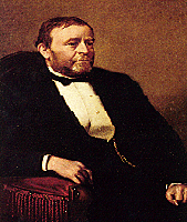 The history of WFO Marquette goes back as far as the National Weather Service itself. In 1870, President Ulysses S. Grant (left) signed a joint resolution of Congress approving the establishment of a weather service under the U.S. War Department's Army Signal Service, including the establishment of the Marquette, MI, office. Service began on November 1, 1870. In 1891, the organization formally became the Weather Bureau and moved to the U.S. Department of Agriculture. The Weather Bureau transferred to the Department of Commerce in 1940 where it remains to this day. Thirty years later in 1970, the Weather Bureau changed its name to the National Weather Service and was placed under the newly established National Oceanic and Atmospheric Administration (NOAA). The history of WFO Marquette goes back as far as the National Weather Service itself. In 1870, President Ulysses S. Grant (left) signed a joint resolution of Congress approving the establishment of a weather service under the U.S. War Department's Army Signal Service, including the establishment of the Marquette, MI, office. Service began on November 1, 1870. In 1891, the organization formally became the Weather Bureau and moved to the U.S. Department of Agriculture. The Weather Bureau transferred to the Department of Commerce in 1940 where it remains to this day. Thirty years later in 1970, the Weather Bureau changed its name to the National Weather Service and was placed under the newly established National Oceanic and Atmospheric Administration (NOAA).
 |
|
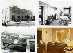
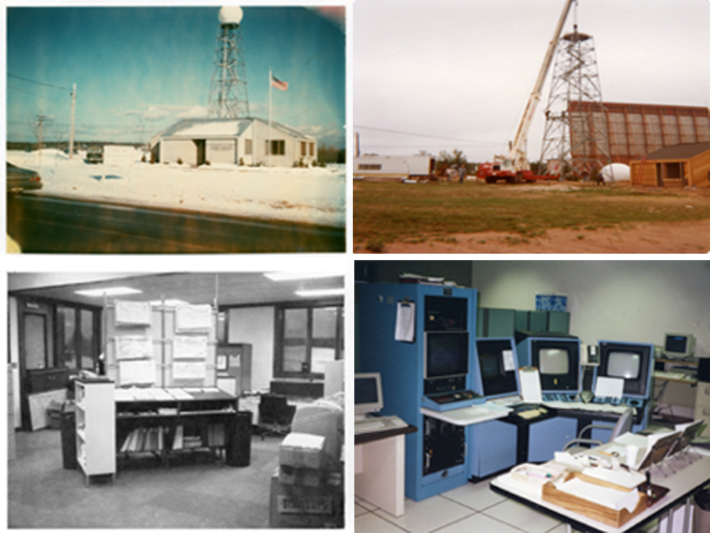
Marquette forecast office in downtown Marquette on corner of Washington and Third Streets.
|
Weather records for the Marquette area were first taken in 1858 by Dr. Blaker as part of a national network of observers reporting telegraphically to the Smithsonian Institute in Washington D.C. in the late 1840s and 1850s. He was also a physician and an amateur weatherman for whom Blaker Street in Marquette was named. On May 11, 1871, the War Department officially took over the weather observations and operated out of an office in the Adams Building on the northwest corner of Front and Spring Streets in downtown Marquette. In April 1885, the office relocated to the Federal Building, known today as the Marquette
 |
| Marquette forecast office 1979-1995. Former Marquette County Airport, Negaunee. |
Post Office building, on the corner of Washington and Third Streets. The office remained in this location until December 22, 1900, when it again relocated to the Marquette County Savings Bank Building on the southeast corner of Washington and Front Streets. The office's final move within the city of Marquette was back to the top floor of the the Post Office building on May 1, 1937. In 1979, the weather office left downtown Marquette and moved to Negaunee township near what was then the actual Marquette County Airport.
 |
|
Current Marquette WFO open since 1995. Former Marquette County Airport, Negaunee, MI.
|
During the mid 1990s, the entire National Weather Service organization underwent a substantial modernization which included the construction of a larger and more technologically capable building for WFO Marquette. This new building was constructed only a few hundred yards away from the old building along U.S. 41 at the junction of M-35. Access to the facility is gained via the side street across from the Michigan State Police Post. This new facility began operations in the late summer of 1995. Also included was an upgrade to the most modern technology, including a new National Doppler radar system called the WSR-88D, and a high-speed technologically-advanced processing, display, and telecommunication network called the Advanced Weather Interactive
 |
|
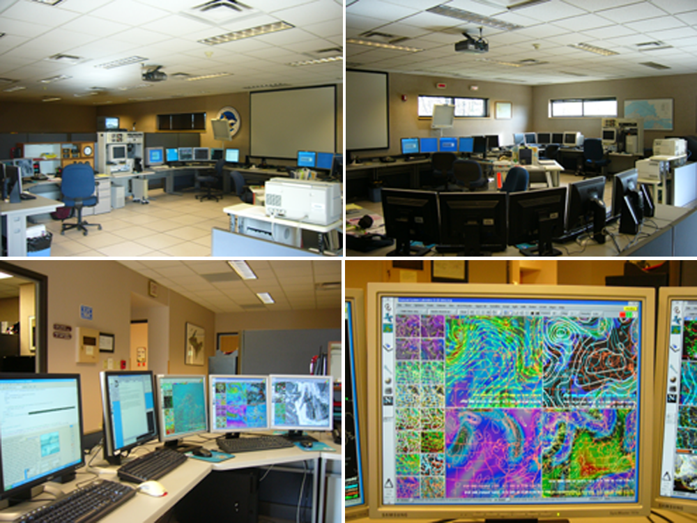
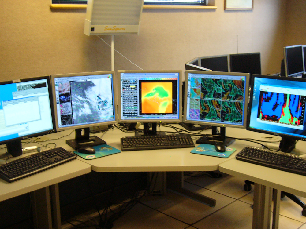
Current Marquette WFO operations area and one of the AWIPS computer stations.
|
Processing System (AWIPS). AWIPS is an interactive computer system that integrates all meteorological, hydrological, satellite, and radar data into one computer workstation, and has become the centerpiece of National Weather Service operations. AWIPS allows forecasters the interactive capability to view, analyze, combine, and manipulate large amounts of graphical and alphanumeric weather data. Thus, AWIPS provides a very efficient and effective means for forecasters to prepare and issue timely, accurate forecasts and warnings. AWIPS is installed in all 122 Weather Forecast Offices (WFOs), 13 regional River Forecast Centers (RFCs), and nine national weather centers.
The Marquette office started in 1870 with a three person staff open only 8 hours a day. By 1979 the office evolved to a seven person staff open 24 hours a day, and today employs a staff of 21 people dedicated to the service of providing the latest up-to-date forecasts, warnings, and weather information to the citizens of Upper Michigan.
 |
|
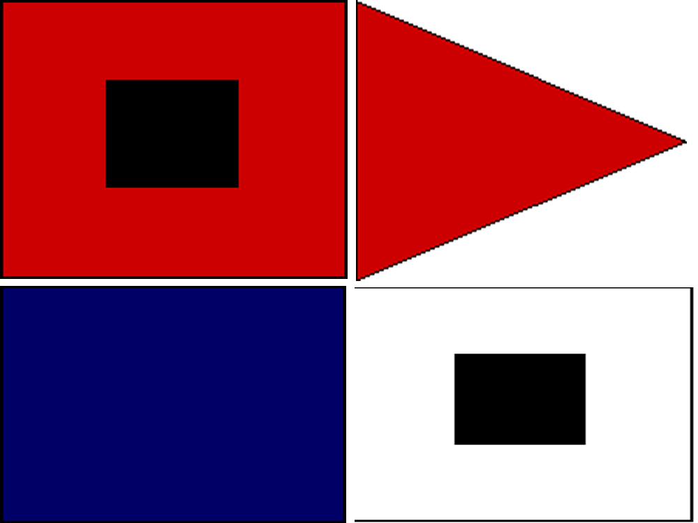
A few of the original warning flags once used to warn citizens of impending weather. Pass mouse over flag for description.
|
Much has changed in the meteorological world since the establishment of WFO Marquette. In the beginning, weather warnings and forecasts were issued using a flag arrangement on the roof of the Adams building in downtown Marquette. Over the years, the National Weather Service communication systems evolved to telegraphs, then to telephones and teletypewriters, and finally to NOAA Weather Radio All Hazards (NWR) and computer/satellite based dissemination systems. Today, residents of upper Michigan receive these forecasts from their choice of outlets, including newspaper, telephone, radio, television, the internet and even through wireless devices like their cell phones.
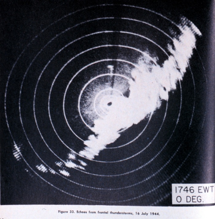
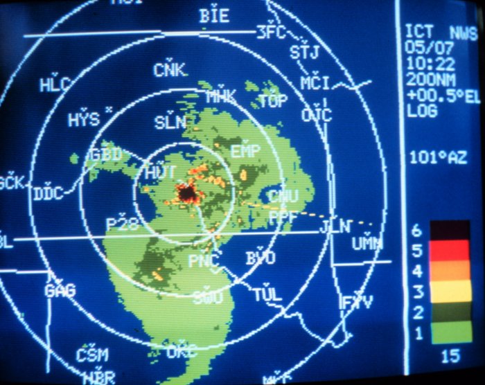
Evolving as well has been the observing equipment used in the forecast and warning process. Basic but invaluable devices like thermometers (temperature), barometers (atmospheric pressure), and anemometers (windspeed and direction) have been around since the beginning and are still used today. However in the last half century, meteorologists have added the technologies of radar, satellites, and atmospheric computer modeling. These technologies in themselves are continuing to evolve, becoming more sophisticated and beneficial to the forecast and warning process with each passing year. The development and use of radar with Doppler capability gives meteorologists the ability to see the speeds and motions within thunderstorms and allows for much faster and accurate detection of severe weather including severe straightline winds, hail, and tornadoes. The images below show some of the advances in radar technology during the past 50 years both in how data is analyzed and also the graphical reflectivity display.
|
|
|
|
|
|
|
|
|
57 S Band radar (50s, 60s, 70s)
|
74 C Band radar (70s, 80s, early 90s)
|
WSR 88 D S Band Doppler Radar (Middle 90s through today)
|
 The National Weather Service and WFO Marquette have a long history of forecasting and hazard warning services to the residents of Upper Michigan. There is little doubt that weather forecasting and the technology to produce forecasts will continue to evolve as our understanding of the atmosphere improves. With all that has changed, our goal has always been the protection of life and property, and in the years to come, we will continue to keep a vigilant watch. The National Weather Service and WFO Marquette have a long history of forecasting and hazard warning services to the residents of Upper Michigan. There is little doubt that weather forecasting and the technology to produce forecasts will continue to evolve as our understanding of the atmosphere improves. With all that has changed, our goal has always been the protection of life and property, and in the years to come, we will continue to keep a vigilant watch. |


 Follow us on YouTube