National Weather Service United States Department of Commerce
Click a location below for detailed forecast.

Last Map Update: Thu, Apr. 25, 2024 at 7:31:20 pm EDT

National Weather Service Louisville, KYNational Weather Service Jackson, KYNational Weather Service Charleston, WV
National Weather Service Nashville, TNZoom
Out

National Weather Service Blacksburg, VA
National Weather Service Huntsville, ALNational Weather Service Peachtree City, GANational Weather Service Greenville-Spartanburg, SC


A gradual warming trend is expected into the weekend with a slight chance for rain on Friday. Breezy winds are possible Friday through Saturday, especially in the higher elevations. Showers and thunderstorms are likely early next week.
Each observation point is apart of our COOP program (Cooperative Observer Program). Each site has a 24 hour observation period that ends and begins at 8 am local time. Each site records temperature, precipitation, and snowfall data. More information about the COOP program can be found here www.nws.noaa.gov/om/coop/ Data began being collected at: Cades Cover on 01/01/1999 || Mount LeConte on 07/01/1987 || Newfound Gap on 01/01/1991 || Sugarlands Visitor Center on 12/01/1921
A gradual warming trend is expected into the weekend with a slight chance for rain on Friday. Breezy winds are possible Friday through Saturday, especially in the higher elevations. Showers and thunderstorms are likely early next week.

 Current Weather Observations...
Location Time
(EDT)
Weather Vsby.
(SM)
Temp.
(ºF)
Dewpt.
(ºF)
Hum.
(%)
Wind
(mph)
Wind Chill / Heat Index
(ºF)
Pres.
(in)
Abingdon VA19:15Clear10673328WSW 6-30.12
Andrews-Murphy NC19:09Clear10733222WSW 3-30.10
Chattanooga TN18:53Mostly Cloudy10754129ESE 3-30.09
Crossville TN18:53Clear10674341NW 8-30.13
Dalton GA19:15Partly Cloudy10715557CALM-30.09
Knoxville TN (McGhee-Tyson)18:53Overcast10733726CALM-30.09
Middlesboro KY19:15Clear10683833N 8-30.13
Monroe Cnty TN19:15Clear10694440CALM-30.09
Morristown TN19:15Clear10694237CALM-30.09
Oak Ridge TN18:53Clear10733929CALM-30.11
Tazewell Cnty VA19:15Clear10643736NNW 5-30.15
Tri-Cities TN18:53Mostly Cloudy10693933S 3-30.11
Wise VA19:15Clear10603538N 7-30.17
Greeneville, TN19:15Clear10683530CALM-30.11


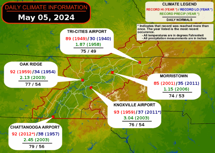
Local Weather History For April 25th...
Storms hit in 2010. 3 tornadoes developed. $340,160 wind damage across entire area.


Briefing Hydrology Past Weather Events Graphical Hazardous Weather Outlook for East Tennessee East Tennessee Observations
Decision Support Hydrology Past Weather Events GHWO Observations Gridded Forecast
Daily Climate for Middle Tennessee Local East Tennessee Climate Tornado Database Tropical Weather Information NOAA Weather Radio
IDSS Point Forecasts Daily Climate Local Climate Tornado Database Tropical Weather Radio
Daily Climate for Middle Tennessee Probabilistic Data for East Tennessee Virtual Tour of the NWS Morristown Office Skywarn Spotter Training for East Tennessee  
Being Prepared Estar Perparado Probabilistic Virtual Tour Spotter Training