000
FPUS54 KMRX 231339
ZFPMRX

Morristown Area Zone Forecasts
National Weather Service Morristown TN
939 AM EDT Tue Apr 23 2024

TNZ099-232115-
Hamilton-
Including the cities of Chattanooga, Lookout Mountain,
and Signal Mountain
939 AM EDT Tue Apr 23 2024

.REST OF TODAY...Sunny. Highs in the lower to mid 70s. South
winds 10 mph or less, becoming southwest this afternoon.
.TONIGHT...Mostly clear in the evening, then becoming partly
cloudy. Lows in the mid 50s. Southwest winds 10 mph or less.
.WEDNESDAY...Partly sunny. Highs in the lower to mid 70s. West
winds 10 mph or less.
.WEDNESDAY NIGHT...Partly cloudy in the evening, then becoming
mostly clear. Lows in the upper 40s. Light winds.
.THURSDAY...Mostly sunny. Highs in the mid to upper 70s. Light
winds.
.THURSDAY NIGHT...Mostly cloudy. A slight chance of showers after
midnight. Lows in the mid to upper 50s. Chance of rain
20 percent.
.FRIDAY...Mostly cloudy in the morning, then becoming partly
sunny. Highs in the mid to upper 70s.
.FRIDAY NIGHT...Mostly cloudy. Lows in the lower 60s.
.SATURDAY...Mostly cloudy. Highs in the mid to upper 70s.
.SATURDAY NIGHT...Mostly cloudy. Lows in the lower 60s.
.SUNDAY...Mostly sunny. Highs in the upper 70s to lower 80s.
.SUNDAY NIGHT...Partly cloudy. A slight chance of showers after
midnight. Lows in the lower 60s. Chance of rain 20 percent.
.MONDAY...Partly sunny. A chance of showers in the morning, then
a chance of showers and thunderstorms in the afternoon. Highs in
the upper 70s to lower 80s. Chance of rain 50 percent.

$$

TNZ069-232115-
Knox-
Including the cities of Bearden, Knoxville, and Lake Forest
939 AM EDT Tue Apr 23 2024

.REST OF TODAY...Sunny. Highs in the lower 70s. Southwest winds
5 to 15 mph with gusts up to 25 mph.
.TONIGHT...Partly cloudy until early morning, then mostly cloudy
with a chance of showers late. Not as cool with lows in the mid
50s. Southwest winds 5 to 15 mph. Chance of rain 40 percent.
.WEDNESDAY...Partly sunny. A chance of showers in the morning.
Highs in the lower 70s. West winds 5 to 10 mph. Chance of rain
30 percent.
.WEDNESDAY NIGHT...Mostly clear. Lows in the upper 40s. Light
winds.
.THURSDAY...Sunny. Highs in the mid 70s. Light winds.
.THURSDAY NIGHT...Partly cloudy in the evening, then becoming
mostly cloudy. Lows in the lower 50s.
.FRIDAY...Mostly cloudy with a 20 percent chance of showers.
Highs in the mid 70s.
.FRIDAY NIGHT...Mostly cloudy. Lows in the upper 50s.
.SATURDAY...Mostly cloudy in the morning, then becoming partly
sunny. Highs around 80.
.SATURDAY NIGHT...Partly cloudy. Lows in the lower 60s.
.SUNDAY...Mostly sunny. Highs in the lower 80s.
.SUNDAY NIGHT...Partly cloudy. A slight chance of showers after
midnight. Lows in the lower 60s. Chance of rain 20 percent.
.MONDAY...Partly sunny. A chance of showers in the morning, then
a chance of showers with a slight chance of thunderstorms in the
afternoon. Highs in the lower 80s. Chance of rain 40 percent.

$$

TNZ017-232115-
Sullivan-
Including the cities of Kingsport, Bristol TN,
and South Holston Dam
939 AM EDT Tue Apr 23 2024

.REST OF TODAY...Sunny. Highs in the mid to upper 60s. Southwest
winds 10 mph or less, increasing to 10 to 15 mph this afternoon.
.TONIGHT...Mostly clear in the evening, then partly cloudy with a
slight chance of showers after midnight. Mostly cloudy with a
chance of showers late. Lows in the upper 40s to lower 50s.
Southwest winds 5 to 15 mph. Chance of rain 50 percent.
.WEDNESDAY...Partly sunny. A chance of showers in the morning,
then a slight chance of showers early in the afternoon. Highs in
the mid to upper 60s. West winds 5 to 10 mph. Chance of rain
40 percent.
.WEDNESDAY NIGHT...Mostly clear. Lows in the lower 40s. Light
winds.
.THURSDAY...Sunny. Highs in the upper 60s to lower 70s. Light
winds.
.THURSDAY NIGHT...Mostly clear in the evening, then becoming
partly cloudy. Lows in the mid to upper 40s.
.FRIDAY...Partly sunny in the morning, then becoming mostly
cloudy. A 20 percent chance of showers. Highs in the upper 60s to
lower 70s.
.FRIDAY NIGHT...Mostly cloudy. Lows in the mid 50s.
.SATURDAY...Partly sunny. Highs in the mid to upper 70s.
.SATURDAY NIGHT...Partly cloudy. Lows in the upper 50s.
.SUNDAY...Mostly sunny. Highs in the upper 70s to lower 80s.
.SUNDAY NIGHT...Partly cloudy. Lows in the upper 50s.
.MONDAY...Mostly sunny. A slight chance of showers in the
morning, then a chance of showers and thunderstorms in the
afternoon. Highs in the upper 70s to lower 80s. Chance of rain
40 percent.

$$

TNZ074-232115-
Sevier Smoky Mountains-
Including the cities of Elkmont and Gatlinburg
939 AM EDT Tue Apr 23 2024

.REST OF TODAY...Sunny. Not as cool with highs in the mid 50s to
lower 70s. Southwest winds 10 mph or less with gusts up to
20 mph, increasing to 10 to 20 mph with gusts up to 35 mph this
afternoon.
.TONIGHT...Partly cloudy until early morning, then mostly cloudy
with a chance of showers late. Lows in the 40s to lower 50s.
Southwest winds 10 to 20 mph with gusts up to 35 mph. Chance of
rain 30 percent.
.WEDNESDAY...Mostly cloudy with a chance of showers in the
morning, then partly sunny with a slight chance of showers early
in the afternoon. Partly sunny late. Highs in the 50s and 60s.
West winds 5 to 15 mph with gusts up to 25 mph. Chance of rain
50 percent.
.WEDNESDAY NIGHT...Partly cloudy in the evening, then becoming
mostly clear. Lows in the mid 30s to upper 40s. North winds
10 mph or less in the evening, becoming light and variable.
.THURSDAY...Sunny. Highs in the upper 50s to lower 70s. Northwest
winds 10 mph or less.
.THURSDAY NIGHT...Partly cloudy in the evening, then becoming
mostly cloudy. Lows in the 40s to lower 50s.
.FRIDAY...Partly sunny with a chance of showers in the morning,
then mostly cloudy with a slight chance of showers in the
afternoon. Highs in the upper 50s to lower 70s. Chance of rain
30 percent.
.FRIDAY NIGHT...Mostly cloudy. A slight chance of showers after
midnight. Lows in the upper 40s and 50s. Chance of rain
20 percent.
.SATURDAY...Mostly cloudy with a 20 percent chance of showers.
Highs in the 60s to mid 70s.
.SATURDAY NIGHT...Mostly cloudy. Lows in the upper 40s to lower
60s.
.SUNDAY...Mostly sunny. A slight chance of showers and
thunderstorms in the afternoon. Highs in the mid 60s to upper
70s. Chance of rain 20 percent.
.SUNDAY NIGHT...Partly cloudy. Lows in the upper 40s to lower
60s.
.MONDAY...Partly sunny. A slight chance of showers in the
morning, then a chance of showers with a slight chance of
thunderstorms in the afternoon. Highs in the mid 60s to upper
70s. Chance of rain 40 percent.

$$

TNZ013-232115-
Campbell-
Including the cities of Fincastle, La Follette, Elk Valley,
Jellico, White Oak, Caryville, and Royal Blue
939 AM EDT Tue Apr 23 2024

.REST OF TODAY...Sunny. Highs in the upper 60s to lower 70s.
Southwest winds 5 to 15 mph. Gusts up to 30 mph this afternoon.
.TONIGHT...Partly cloudy in the evening, then mostly cloudy with
a chance of showers after midnight. Not as cool with lows in the
lower 50s. Southwest winds 5 to 15 mph with gusts up to 25 mph.
Chance of rain 50 percent.
.WEDNESDAY...Partly sunny. A chance of showers in the morning.
Highs in the upper 60s to lower 70s. Northwest winds 5 to 10 mph.
Chance of rain 40 percent.
.WEDNESDAY NIGHT...Mostly clear. Lows in the mid 40s. North winds
10 mph or less.
.THURSDAY...Sunny. Highs in the lower to mid 70s. Light winds.
.THURSDAY NIGHT...Partly cloudy in the evening, then becoming
mostly cloudy. Lows in the lower 50s.
.FRIDAY...Mostly cloudy. A chance of showers in the morning, then
a slight chance of showers and thunderstorms in the afternoon.
Highs in the lower 70s. Chance of rain 40 percent.
.FRIDAY NIGHT...Mostly cloudy. Lows in the upper 50s.
.SATURDAY...Mostly cloudy in the morning, then becoming partly
sunny. Highs in the mid to upper 70s.
.SATURDAY NIGHT...Partly cloudy. Lows in the lower 60s.
.SUNDAY...Mostly sunny. Highs in the upper 70s to lower 80s.
.SUNDAY NIGHT...Partly cloudy. A slight chance of showers after
midnight. Lows in the lower 60s. Chance of rain 20 percent.
.MONDAY...Partly sunny. A chance of showers in the morning, then
a chance of showers and thunderstorms in the afternoon. Highs in
the mid to upper 70s. Chance of rain 50 percent.

$$

TNZ098-232115-
Marion-
Including the cities of South Pittsburg, Haletown (Guild),
Jasper, Martin Springs, Whitwell, Powells Crossroads,
and Monteagle
839 AM CDT Tue Apr 23 2024

.REST OF TODAY...Sunny. Highs in the lower 70s. Southwest winds
10 mph or less, increasing to 10 to 15 mph this afternoon.
.TONIGHT...Mostly clear in the evening, then becoming mostly
cloudy. Lows in the mid 50s. Southwest winds 5 to 10 mph.
.WEDNESDAY...Partly sunny. A slight chance of showers in the
morning. Highs in the lower to mid 70s. West winds 5 to 10 mph.
Chance of rain 20 percent.
.WEDNESDAY NIGHT...Partly cloudy in the evening, then clearing.
Lows in the upper 40s. Light winds.
.THURSDAY...Mostly sunny. Highs in the lower to mid 70s. Light
winds.
.THURSDAY NIGHT...Mostly cloudy. A slight chance of showers after
midnight. Lows in the upper 50s. Chance of rain 20 percent.
.FRIDAY...Mostly cloudy with a slight chance of showers in the
morning, then partly sunny in the afternoon. Highs in the lower
to mid 70s. Chance of rain 20 percent.
.FRIDAY NIGHT...Mostly cloudy. Lows in the lower 60s.
.SATURDAY...Mostly cloudy. Highs in the mid to upper 70s.
.SATURDAY NIGHT...Partly cloudy in the evening, then becoming
mostly cloudy. Lows in the lower 60s.
.SUNDAY...Mostly sunny. Highs in the upper 70s to lower 80s.
.SUNDAY NIGHT...Partly cloudy in the evening, then mostly cloudy
with a slight chance of showers after midnight. Lows in the lower
60s. Chance of rain 20 percent.
.MONDAY...Partly sunny. A chance of showers in the morning, then
a chance of showers and thunderstorms in the afternoon. Highs in
the upper 70s to lower 80s. Chance of rain 50 percent.

$$

TNZ081-232115-
Sequatchie-
Including the cities of Cagle, Dunlap, Cartwright, and Lone Oak
839 AM CDT Tue Apr 23 2024

.REST OF TODAY...Sunny. Highs in the upper 60s to lower 70s.
Southwest winds 5 to 15 mph with gusts up to 25 mph.
.TONIGHT...Partly cloudy until early morning, then mostly cloudy
with a slight chance of showers late. Lows in the lower 50s.
Southwest winds 5 to 15 mph. Chance of rain 20 percent.
.WEDNESDAY...Partly sunny. A slight chance of showers in the
morning. Highs in the lower 70s. Northwest winds 5 to 10 mph.
Chance of rain 20 percent.
.WEDNESDAY NIGHT...Partly cloudy in the evening, then becoming
mostly clear. Lows in the upper 40s. Light winds.
.THURSDAY...Mostly sunny. Highs in the lower to mid 70s. Light
winds.
.THURSDAY NIGHT...Mostly cloudy. A slight chance of showers after
midnight. Lows in the mid 50s. Chance of rain 20 percent.
.FRIDAY...Mostly cloudy with a slight chance of showers in the
morning, then partly sunny in the afternoon. Highs in the lower
to mid 70s. Chance of rain 20 percent.
.FRIDAY NIGHT...Mostly cloudy. Lows in the lower 60s.
.SATURDAY...Mostly cloudy. Highs in the lower to mid 70s.
.SATURDAY NIGHT...Partly cloudy in the evening, then becoming
mostly cloudy. Lows in the lower 60s.
.SUNDAY...Mostly sunny. Highs in the upper 70s to lower 80s.
.SUNDAY NIGHT...Partly cloudy in the evening, then mostly cloudy
with a slight chance of showers after midnight. Lows in the lower
60s. Chance of rain 20 percent.
.MONDAY...Partly sunny. A chance of showers in the morning, then
a chance of showers and thunderstorms in the afternoon. Highs in
the upper 70s to lower 80s. Chance of rain 50 percent.

$$

TNZ082-232115-
Bledsoe-
Including the cities of Old Cumberland, Palio, Melvine,
Mount Crest, Pikeville, and Brayton
839 AM CDT Tue Apr 23 2024

.REST OF TODAY...Sunny. Highs in the upper 60s to lower 70s.
Southwest winds 5 to 15 mph with gusts up to 25 mph.
.TONIGHT...Partly cloudy until early morning, then mostly cloudy
with a chance of showers late. Lows in the lower 50s. Southwest
winds 5 to 15 mph. Chance of rain 40 percent.
.WEDNESDAY...Partly sunny. A slight chance of showers in the
morning. Highs in the lower 70s. Northwest winds 5 to 10 mph.
Chance of rain 20 percent.
.WEDNESDAY NIGHT...Mostly clear. Lows in the upper 40s. Light
winds.
.THURSDAY...Mostly sunny. Highs in the lower to mid 70s. Light
winds.
.THURSDAY NIGHT...Mostly cloudy. A slight chance of showers after
midnight. Lows in the lower 50s. Chance of rain 20 percent.
.FRIDAY...Mostly cloudy with a slight chance of showers in the
morning, then partly sunny in the afternoon. Highs in the lower
to mid 70s. Chance of rain 20 percent.
.FRIDAY NIGHT...Mostly cloudy. Lows around 60.
.SATURDAY...Mostly cloudy. Highs in the mid to upper 70s.
.SATURDAY NIGHT...Partly cloudy in the evening, then becoming
mostly cloudy. Lows in the lower 60s.
.SUNDAY...Mostly sunny. Highs in the upper 70s to lower 80s.
.SUNDAY NIGHT...Partly cloudy in the evening, then mostly cloudy
with a slight chance of showers after midnight. Lows in the lower
60s. Chance of rain 20 percent.
.MONDAY...Partly sunny with a chance of showers in the morning,
then mostly cloudy with a chance of showers and thunderstorms in
the afternoon. Highs in the upper 70s to lower 80s. Chance of
rain 50 percent.

$$

TNZ100-232115-
Bradley-
Including the cities of Cleveland and Tasso
939 AM EDT Tue Apr 23 2024

.REST OF TODAY...Sunny. Highs in the lower 70s. Southwest winds
5 to 15 mph with gusts up to 25 mph.
.TONIGHT...Mostly clear in the evening, then becoming partly
cloudy. Not as cool with lows in the lower 50s. South winds 5 to
10 mph.
.WEDNESDAY...Mostly cloudy in the morning, then becoming mostly
sunny. Highs in the mid 70s. West winds 10 mph or less.
.WEDNESDAY NIGHT...Partly cloudy in the evening, then becoming
mostly clear. Lows in the upper 40s. Light winds.
.THURSDAY...Mostly sunny. Highs in the mid 70s. Light winds.
.THURSDAY NIGHT...Mostly cloudy. Lows in the mid 50s.
.FRIDAY...Mostly cloudy in the morning, then becoming partly
sunny. Highs in the mid 70s.
.FRIDAY NIGHT...Mostly cloudy. Lows in the lower 60s.
.SATURDAY...Mostly cloudy. Highs in the upper 70s.
.SATURDAY NIGHT...Partly cloudy in the evening, then becoming
mostly cloudy. Lows in the lower 60s.
.SUNDAY...Mostly sunny. Highs in the lower 80s.
.SUNDAY NIGHT...Partly cloudy. A slight chance of showers after
midnight. Lows in the lower 60s. Chance of rain 20 percent.
.MONDAY...Partly sunny. A slight chance of showers in the
morning, then a chance of showers with a slight chance of
thunderstorms in the afternoon. Highs in the lower 80s. Chance of
rain 40 percent.

$$

TNZ101-232115-
West Polk-
Including the cities of Conasauga, Archville, Benton, Parksville,
and Reliance
939 AM EDT Tue Apr 23 2024

.REST OF TODAY...Sunny. Highs in the upper 60s to lower 70s.
Southwest winds 10 mph or less, increasing to 10 to 15 mph this
afternoon.
.TONIGHT...Mostly clear in the evening, then becoming partly
cloudy. Not as cool with lows in the lower 50s. Southwest winds
5 to 10 mph.
.WEDNESDAY...Mostly cloudy with a slight chance of showers in the
morning, then partly sunny in the afternoon. Highs in the lower
70s. West winds 10 mph or less. Chance of rain 20 percent.
.WEDNESDAY NIGHT...Mostly clear. Lows in the upper 40s to lower
50s. Light winds.
.THURSDAY...Mostly sunny. Highs in the lower to mid 70s. Light
winds.
.THURSDAY NIGHT...Mostly cloudy. Lows in the mid 50s.
.FRIDAY...Mostly cloudy in the morning, then becoming partly
sunny. Highs in the lower to mid 70s.
.FRIDAY NIGHT...Mostly cloudy. Lows in the lower 60s.
.SATURDAY...Mostly cloudy. Highs in the mid to upper 70s.
.SATURDAY NIGHT...Partly cloudy. Lows in the lower 60s.
.SUNDAY...Mostly sunny. Highs in the upper 70s to lower 80s.
.SUNDAY NIGHT...Partly cloudy. A slight chance of showers after
midnight. Lows in the lower 60s. Chance of rain 20 percent.
.MONDAY...Partly sunny. A slight chance of showers in the
morning, then a chance of showers with a slight chance of
thunderstorms in the afternoon. Highs in the upper 70s to lower
80s. Chance of rain 40 percent.

$$

TNZ102-232115-
East Polk-
Including the cities of Big Frog Mountain, Ducktown,
and Turtletown
939 AM EDT Tue Apr 23 2024

.REST OF TODAY...Sunny. Highs in the upper 50s to lower 70s.
South winds 10 mph or less, becoming southwest this afternoon.
.TONIGHT...Mostly clear in the evening, then becoming partly
cloudy. Not as cool with lows in the lower 50s. Southwest winds
5 to 10 mph.
.WEDNESDAY...Mostly cloudy with a slight chance of showers in the
morning, then partly sunny in the afternoon. Highs in the upper
50s to lower 70s. West winds 10 mph or less. Chance of rain
20 percent.
.WEDNESDAY NIGHT...Mostly clear. Lows in the mid to upper 40s.
Light winds.
.THURSDAY...Mostly sunny. Highs in the 60s to mid 70s. Light
winds.
.THURSDAY NIGHT...Mostly cloudy. Lows in the mid 50s.
.FRIDAY...Mostly cloudy in the morning, then becoming partly
sunny. Highs in the 60s to mid 70s.
.FRIDAY NIGHT...Mostly cloudy. Lows in the upper 50s.
.SATURDAY...Mostly cloudy. Highs in the mid 60s to upper 70s.
.SATURDAY NIGHT...Mostly cloudy in the evening, then becoming
partly cloudy. Lows around 60.
.SUNDAY...Mostly sunny. Highs in the upper 60s to lower 80s.
.SUNDAY NIGHT...Partly cloudy. Lows in the upper 50s.
.MONDAY...Partly sunny. A slight chance of showers in the
morning, then a chance of showers with a slight chance of
thunderstorms in the afternoon. Highs in the upper 60s to lower
80s. Chance of rain 40 percent.

$$

TNZ083-232115-
Rhea-
Including the cities of Dayton, Evensville, Old Washington,
Grandview, and Spring City
939 AM EDT Tue Apr 23 2024

.REST OF TODAY...Sunny. Highs in the upper 60s to lower 70s.
Southwest winds 5 to 15 mph with gusts up to 25 mph.
.TONIGHT...Mostly clear in the evening, then partly cloudy with a
slight chance of showers after midnight. Lows in the lower 50s.
Southwest winds 5 to 15 mph. Chance of rain 20 percent.
.WEDNESDAY...Partly sunny. A slight chance of showers in the
morning. Highs in the lower to mid 70s. Northwest winds 5 to
10 mph. Chance of rain 20 percent.
.WEDNESDAY NIGHT...Mostly clear. Lows in the mid 40s. Light
winds.
.THURSDAY...Sunny. Highs in the lower to mid 70s. Light winds.
.THURSDAY NIGHT...Mostly cloudy. Lows in the lower 50s.
.FRIDAY...Mostly cloudy with a slight chance of showers in the
morning, then partly sunny in the afternoon. Highs in the lower
to mid 70s. Chance of rain 20 percent.
.FRIDAY NIGHT...Mostly cloudy. Lows around 60.
.SATURDAY...Mostly cloudy. Highs in the mid to upper 70s.
.SATURDAY NIGHT...Partly cloudy in the evening, then becoming
mostly cloudy. Lows around 60.
.SUNDAY...Mostly sunny. Highs in the upper 70s to lower 80s.
.SUNDAY NIGHT...Partly cloudy. A slight chance of showers after
midnight. Lows in the lower 60s. Chance of rain 20 percent.
.MONDAY...Partly sunny. A chance of showers in the morning, then
a chance of showers and thunderstorms in the afternoon. Highs in
the upper 70s to lower 80s. Chance of rain 50 percent.

$$

TNZ084-232115-
Meigs-
Including the city of Big Spring
939 AM EDT Tue Apr 23 2024

.REST OF TODAY...Sunny. Highs in the lower 70s. Southwest winds
5 to 15 mph with gusts up to 25 mph.
.TONIGHT...Partly cloudy until early morning, then mostly cloudy
with a slight chance of showers late. Lows in the lower 50s.
Southwest winds 5 to 10 mph. Chance of rain 20 percent.
.WEDNESDAY...Partly sunny. A slight chance of showers in the
morning. Highs in the mid 70s. Light winds. Chance of rain
20 percent.
.WEDNESDAY NIGHT...Mostly clear. Lows in the mid 40s. Light
winds.
.THURSDAY...Sunny. Highs in the mid 70s. Light winds.
.THURSDAY NIGHT...Mostly cloudy. Lows in the lower 50s.
.FRIDAY...Mostly cloudy with a slight chance of showers in the
morning, then partly sunny in the afternoon. Highs in the mid
70s. Chance of rain 20 percent.
.FRIDAY NIGHT...Mostly cloudy. Lows around 60.
.SATURDAY...Mostly cloudy. Highs in the upper 70s.
.SATURDAY NIGHT...Partly cloudy in the evening, then becoming
mostly cloudy. Lows in the lower 60s.
.SUNDAY...Mostly sunny. Highs in the lower 80s.
.SUNDAY NIGHT...Partly cloudy. A slight chance of showers after
midnight. Lows in the lower 60s. Chance of rain 20 percent.
.MONDAY...Partly sunny. A chance of showers in the morning, then
a chance of showers and thunderstorms in the afternoon. Highs in
the lower 80s. Chance of rain 40 percent.

$$

TNZ085-232115-
McMinn-
Including the cities of Athens, Clear Water, Dentville,
and Etowah
939 AM EDT Tue Apr 23 2024

.REST OF TODAY...Sunny. Highs in the lower 70s. Southwest winds
5 to 15 mph with gusts up to 25 mph.
.TONIGHT...Partly cloudy until early morning, then mostly cloudy
with a slight chance of showers late. Not as cool with lows in
the lower 50s. Southwest winds 5 to 10 mph. Chance of rain
20 percent.
.WEDNESDAY...Mostly cloudy with a slight chance of showers in the
morning, then partly sunny in the afternoon. Highs in the mid
70s. West winds 10 mph or less. Chance of rain 20 percent.
.WEDNESDAY NIGHT...Mostly clear. Lows in the mid 40s. Light
winds.
.THURSDAY...Sunny. Highs in the mid 70s. Light winds.
.THURSDAY NIGHT...Mostly cloudy. Lows in the lower 50s.
.FRIDAY...Mostly cloudy with a slight chance of showers in the
morning, then partly sunny in the afternoon. Highs in the mid
70s. Chance of rain 20 percent.
.FRIDAY NIGHT...Mostly cloudy. Lows in the lower 60s.
.SATURDAY...Mostly cloudy. Highs in the upper 70s.
.SATURDAY NIGHT...Partly cloudy. Lows in the lower 60s.
.SUNDAY...Mostly sunny. Highs in the lower 80s.
.SUNDAY NIGHT...Partly cloudy. A slight chance of showers after
midnight. Lows in the lower 60s. Chance of rain 20 percent.
.MONDAY...Partly sunny. A slight chance of showers in the
morning, then a chance of showers with a slight chance of
thunderstorms in the afternoon. Highs in the lower 80s. Chance of
rain 40 percent.

$$

TNZ086-232115-
Northwest Monroe-
Including the cities of Sweetwater, Madisonville,
and Bullet Creek
939 AM EDT Tue Apr 23 2024

.REST OF TODAY...Sunny. Highs in the lower 70s. Southwest winds
5 to 15 mph with gusts up to 25 mph.
.TONIGHT...Partly cloudy until early morning, then mostly cloudy
with a slight chance of showers late. Not as cool with lows in
the lower 50s. Southwest winds 5 to 10 mph. Chance of rain
20 percent.
.WEDNESDAY...Mostly cloudy with a slight chance of showers in the
morning, then partly sunny in the afternoon. Highs in the lower
70s. West winds 10 mph or less. Chance of rain 20 percent.
.WEDNESDAY NIGHT...Mostly clear. Lows in the mid to upper 40s.
Light winds.
.THURSDAY...Sunny. Highs in the mid 70s. Light winds.
.THURSDAY NIGHT...Partly cloudy in the evening, then becoming
mostly cloudy. Lows in the lower to mid 50s.
.FRIDAY...Mostly cloudy. A slight chance of showers in the
morning. Highs in the mid 70s. Chance of rain 20 percent.
.FRIDAY NIGHT...Mostly cloudy. Lows in the lower 60s.
.SATURDAY...Mostly cloudy in the morning, then becoming partly
sunny. Highs in the upper 70s.
.SATURDAY NIGHT...Partly cloudy. Lows in the lower 60s.
.SUNDAY...Mostly sunny. Highs in the lower 80s.
.SUNDAY NIGHT...Partly cloudy. A slight chance of showers after
midnight. Lows in the lower 60s. Chance of rain 20 percent.
.MONDAY...Partly sunny. A slight chance of showers in the
morning, then a chance of showers with a slight chance of
thunderstorms in the afternoon. Highs in the lower 80s. Chance of
rain 40 percent.

$$

TNZ087-232115-
Southeast Monroe-
Including the cities of Citico and Coker Creek
939 AM EDT Tue Apr 23 2024

.REST OF TODAY...Sunny. Highs in the upper 50s to lower 70s.
Southwest winds 5 to 15 mph with gusts up to 25 mph.
.TONIGHT...Partly cloudy until early morning, then a slight
chance of showers late. Lows in the mid 40s to mid 50s. Southwest
winds 5 to 15 mph with gusts up to 25 mph. Chance of rain
20 percent.
.WEDNESDAY...Mostly cloudy with a chance of showers in the
morning, then partly sunny in the afternoon. Highs in the upper
50s to lower 70s. West winds 5 to 10 mph. Chance of rain
40 percent.
.WEDNESDAY NIGHT...Mostly clear. Lows in the 40s. Light winds.
.THURSDAY...Sunny. Highs in the 60s to mid 70s. Light winds.
.THURSDAY NIGHT...Partly cloudy in the evening, then becoming
mostly cloudy. Lows in the upper 40s to mid 50s.
.FRIDAY...Mostly cloudy. A slight chance of showers in the
morning. Highs in the 60s to mid 70s. Chance of rain 20 percent.
.FRIDAY NIGHT...Mostly cloudy. Lows in the 50s to lower 60s.
.SATURDAY...Mostly cloudy. Highs in the 60s and 70s.
.SATURDAY NIGHT...Mostly cloudy in the evening, then becoming
partly cloudy. Lows in the 50s to lower 60s.
.SUNDAY...Mostly sunny. Highs in the upper 60s to lower 80s.
.SUNDAY NIGHT...Partly cloudy. A slight chance of showers after
midnight. Lows in the 50s to lower 60s. Chance of rain
20 percent.
.MONDAY...Partly sunny. A slight chance of showers in the
morning, then a chance of showers with a slight chance of
thunderstorms in the afternoon. Highs in the upper 60s to lower
80s. Chance of rain 40 percent.

$$

TNZ067-232115-
Roane-
Including the cities of Harriman, Eagle Furnace, Rockwood,
Bradbury, Fairview, Kingston, and Oliver Springs
939 AM EDT Tue Apr 23 2024

.REST OF TODAY...Sunny. Highs in the lower 70s. Southwest winds
5 to 15 mph with gusts up to 25 mph.
.TONIGHT...Mostly clear in the evening, then partly cloudy with a
slight chance of showers after midnight. Mostly cloudy with a
chance of showers late. Not as cool with lows in the lower 50s.
Southwest winds 5 to 10 mph. Chance of rain 40 percent.
.WEDNESDAY...Partly sunny. A chance of showers in the morning.
Highs in the mid 70s. West winds 10 mph or less. Chance of rain
30 percent.
.WEDNESDAY NIGHT...Mostly clear. Lows in the mid 40s. Light
winds.
.THURSDAY...Sunny. Highs in the mid 70s. Light winds.
.THURSDAY NIGHT...Partly cloudy in the evening, then becoming
mostly cloudy. Lows in the lower 50s.
.FRIDAY...Mostly cloudy. A slight chance of showers in the
morning. Highs in the mid 70s. Chance of rain 20 percent.
.FRIDAY NIGHT...Mostly cloudy. Lows around 60.
.SATURDAY...Mostly cloudy in the morning, then becoming partly
sunny. Highs in the upper 70s.
.SATURDAY NIGHT...Partly cloudy. Lows in the lower 60s.
.SUNDAY...Mostly sunny. Highs in the lower 80s.
.SUNDAY NIGHT...Partly cloudy. A slight chance of showers after
midnight. Lows in the lower 60s. Chance of rain 20 percent.
.MONDAY...Partly sunny. A chance of showers in the morning, then
a chance of showers and thunderstorms in the afternoon. Highs in
the lower 80s. Chance of rain 40 percent.

$$

TNZ068-232115-
Loudon-
Including the cities of Lenoir City and Loudon
939 AM EDT Tue Apr 23 2024

.REST OF TODAY...Sunny. Highs in the lower 70s. Southwest winds
5 to 15 mph with gusts up to 25 mph.
.TONIGHT...Partly cloudy until early morning, then mostly cloudy
with a chance of showers late. Not as cool with lows in the lower
50s. Southwest winds 5 to 15 mph. Chance of rain 30 percent.
.WEDNESDAY...Partly sunny. A slight chance of showers in the
morning. Highs in the lower 70s. West winds 10 mph or less.
Chance of rain 20 percent.
.WEDNESDAY NIGHT...Mostly clear. Lows in the mid 40s. Light
winds.
.THURSDAY...Sunny. Highs in the mid 70s. Light winds.
.THURSDAY NIGHT...Partly cloudy in the evening, then becoming
mostly cloudy. Lows in the lower 50s.
.FRIDAY...Mostly cloudy. A slight chance of showers in the
morning. Highs in the mid 70s. Chance of rain 20 percent.
.FRIDAY NIGHT...Mostly cloudy. Lows around 60.
.SATURDAY...Mostly cloudy in the morning, then becoming partly
sunny. Highs in the upper 70s.
.SATURDAY NIGHT...Partly cloudy. Lows in the lower 60s.
.SUNDAY...Mostly sunny. Highs in the lower 80s.
.SUNDAY NIGHT...Partly cloudy. A slight chance of showers after
midnight. Lows in the lower 60s. Chance of rain 20 percent.
.MONDAY...Partly sunny. A slight chance of showers in the
morning, then a chance of showers with a slight chance of
thunderstorms in the afternoon. Highs in the lower 80s. Chance of
rain 40 percent.

$$

TNZ071-232115-
Northwest Blount-
Including the cities of Happy Valley, Maryville, and Alcoa
939 AM EDT Tue Apr 23 2024

.REST OF TODAY...Sunny. Highs in the lower 70s. Southwest winds
5 to 15 mph with gusts up to 25 mph.
.TONIGHT...Partly cloudy until early morning, then mostly cloudy
with a chance of showers late. Lows in the lower to mid 50s.
Southwest winds 5 to 15 mph. Chance of rain 30 percent.
.WEDNESDAY...Mostly cloudy with a chance of showers in the
morning, then partly sunny in the afternoon. Highs in the upper
60s to lower 70s. West winds 5 to 10 mph. Chance of rain
40 percent.
.WEDNESDAY NIGHT...Mostly clear. Lows in the mid to upper 40s.
Light winds.
.THURSDAY...Sunny. Highs in the lower to mid 70s. Light winds.
.THURSDAY NIGHT...Partly cloudy in the evening, then becoming
mostly cloudy. Lows in the lower to mid 50s.
.FRIDAY...Mostly cloudy. A slight chance of showers in the
morning. Highs in the mid 70s. Chance of rain 20 percent.
.FRIDAY NIGHT...Mostly cloudy. Lows in the upper 50s to lower
60s.
.SATURDAY...Mostly cloudy in the morning, then becoming partly
sunny. Highs in the mid to upper 70s.
.SATURDAY NIGHT...Partly cloudy. Lows in the upper 50s to lower
60s.
.SUNDAY...Mostly sunny. Highs in the lower to mid 80s.
.SUNDAY NIGHT...Mostly clear in the evening, then partly cloudy
with a slight chance of showers after midnight. Lows in the upper
50s to lower 60s. Chance of rain 20 percent.
.MONDAY...Partly sunny. A slight chance of showers in the
morning, then a chance of showers with a slight chance of
thunderstorms in the afternoon. Highs in the lower 80s. Chance of
rain 40 percent.

$$

TNZ072-232115-
Blount Smoky Mountains-
Including the city of Cades Cove
939 AM EDT Tue Apr 23 2024

.REST OF TODAY...Sunny. Not as cool with highs in the upper 50s
to lower 70s. Southwest winds 10 mph or less with gusts up to
20 mph, increasing to 10 to 15 mph with gusts up to 30 mph this
afternoon.
.TONIGHT...Partly cloudy until early morning, then mostly cloudy
with a chance of showers late. Lows in the mid 40s to mid 50s.
Southwest winds 10 to 20 mph with gusts up to 30 mph. Chance of
rain 30 percent.
.WEDNESDAY...Mostly cloudy with a chance of showers in the
morning, then partly sunny with a slight chance of showers early
in the afternoon. Partly sunny late. Highs in the mid 50s to
lower 70s. West winds 5 to 15 mph. Chance of rain 40 percent.
.WEDNESDAY NIGHT...Mostly clear. Lows in the 40s. Light winds.
.THURSDAY...Sunny. Highs in the 60s to mid 70s. Light winds.
.THURSDAY NIGHT...Partly cloudy in the evening, then becoming
mostly cloudy. Lows in the upper 40s to mid 50s.
.FRIDAY...Partly sunny in the morning, then becoming mostly
cloudy. A 20 percent chance of showers. Highs in the 60s to mid
70s.
.FRIDAY NIGHT...Mostly cloudy. Lows in the 50s to lower 60s.
.SATURDAY...Mostly cloudy in the morning, then becoming partly
sunny. Highs in the 60s and 70s.
.SATURDAY NIGHT...Mostly cloudy in the evening, then becoming
partly cloudy. Lows in the 50s to lower 60s.
.SUNDAY...Mostly sunny. Highs in the upper 60s to lower 80s.
.SUNDAY NIGHT...Partly cloudy. Lows in the 50s to lower 60s.
.MONDAY...Partly sunny. A slight chance of showers in the
morning, then a chance of showers with a slight chance of
thunderstorms in the afternoon. Highs in the mid 60s to lower
80s. Chance of rain 40 percent.

$$

TNZ035-232115-
Morgan-
Including the cities of Pine Orchard, High Point, and Petros
939 AM EDT Tue Apr 23 2024

.REST OF TODAY...Sunny. Highs in the upper 60s to lower 70s.
Southwest winds 5 to 15 mph with gusts up to 25 mph.
.TONIGHT...Partly cloudy in the evening, then a slight chance of
showers after midnight. Mostly cloudy with a chance of showers
late. Not as cool with lows in the lower 50s. Southwest winds
5 to 15 mph with gusts up to 25 mph. Chance of rain 50 percent.
.WEDNESDAY...Mostly sunny. A chance of showers in the morning.
Highs in the upper 60s to lower 70s. Northwest winds 5 to 10 mph.
Chance of rain 40 percent.
.WEDNESDAY NIGHT...Mostly clear. Lows in the mid 40s. North winds
10 mph or less.
.THURSDAY...Sunny. Highs in the lower to mid 70s. Light winds.
.THURSDAY NIGHT...Partly cloudy in the evening, then becoming
mostly cloudy. Lows in the lower 50s.
.FRIDAY...Mostly cloudy. A chance of showers in the morning, then
a slight chance of showers and thunderstorms in the afternoon.
Highs in the lower 70s. Chance of rain 30 percent.
.FRIDAY NIGHT...Mostly cloudy. Lows in the upper 50s.
.SATURDAY...Mostly cloudy in the morning, then becoming partly
sunny. Highs in the mid to upper 70s.
.SATURDAY NIGHT...Partly cloudy. Lows around 60.
.SUNDAY...Mostly sunny. Highs in the upper 70s to lower 80s.
.SUNDAY NIGHT...Partly cloudy. A slight chance of showers after
midnight. Lows around 60. Chance of rain 20 percent.
.MONDAY...Partly sunny. A chance of showers in the morning, then
a chance of showers and thunderstorms in the afternoon. Highs in
the mid to upper 70s. Chance of rain 50 percent.

$$

TNZ036-232115-
Anderson-
Including the cities of Oak Ridge and Clinton
939 AM EDT Tue Apr 23 2024

.REST OF TODAY...Sunny. Highs in the mid to upper 60s. Southwest
winds 5 to 15 mph with gusts up to 30 mph.
.TONIGHT...Partly cloudy in the evening, then a slight chance of
showers after midnight. Mostly cloudy with a chance of showers
late. Lows in the lower to mid 50s. Southwest winds 5 to 15 mph.
Gusts up to 30 mph in the evening. Chance of rain 50 percent.
.WEDNESDAY...Mostly sunny. A chance of showers in the morning.
Highs in the upper 60s to lower 70s. West winds 5 to 10 mph.
Chance of rain 40 percent.
.WEDNESDAY NIGHT...Mostly clear. Lows in the mid 40s. North winds
10 mph or less.
.THURSDAY...Sunny. Highs in the lower to mid 70s. Light winds.
.THURSDAY NIGHT...Partly cloudy in the evening, then becoming
mostly cloudy. Lows in the lower 50s.
.FRIDAY...Partly sunny with a chance of showers in the morning,
then mostly cloudy with a slight chance of showers in the
afternoon. Highs in the upper 60s to lower 70s. Chance of rain
30 percent.
.FRIDAY NIGHT...Mostly cloudy. Lows in the upper 50s.
.SATURDAY...Mostly cloudy in the morning, then becoming partly
sunny. Highs in the mid to upper 70s.
.SATURDAY NIGHT...Partly cloudy. Lows around 60.
.SUNDAY...Mostly sunny. Highs in the upper 70s to lower 80s.
.SUNDAY NIGHT...Partly cloudy. A slight chance of showers after
midnight. Lows around 60. Chance of rain 20 percent.
.MONDAY...Partly sunny. A chance of showers in the morning, then
a chance of showers and thunderstorms in the afternoon. Highs in
the mid to upper 70s. Chance of rain 50 percent.

$$

TNZ073-232115-
North Sevier-
Including the cities of Harrisburg, Kodak, McMahan, Sevierville,
Seymour, and Pigeon Forge
939 AM EDT Tue Apr 23 2024

.REST OF TODAY...Sunny. Highs in the lower 70s. West winds 10 mph
or less, becoming southwest this afternoon.
.TONIGHT...Partly cloudy until early morning, then mostly cloudy
with a chance of showers late. Not as cool with lows in the lower
to mid 50s. Southwest winds 10 to 15 mph. Chance of rain
40 percent.
.WEDNESDAY...Mostly cloudy with a chance of showers in the
morning, then partly sunny in the afternoon. Highs in the upper
60s. West winds 5 to 10 mph. Chance of rain 40 percent.
.WEDNESDAY NIGHT...Mostly clear. Lows in the mid 40s. Light
winds.
.THURSDAY...Sunny. Highs in the lower 70s. Light winds.
.THURSDAY NIGHT...Partly cloudy. Lows around 50.
.FRIDAY...Partly sunny in the morning, then becoming mostly
cloudy. A 20 percent chance of showers. Highs in the lower to mid
70s.
.FRIDAY NIGHT...Mostly cloudy. Lows in the upper 50s.
.SATURDAY...Mostly cloudy in the morning, then becoming partly
sunny. Highs in the mid to upper 70s.
.SATURDAY NIGHT...Partly cloudy. Lows in the upper 50s.
.SUNDAY...Mostly sunny. Highs in the lower 80s.
.SUNDAY NIGHT...Mostly clear in the evening, then becoming partly
cloudy. Lows in the upper 50s.
.MONDAY...Partly sunny. A slight chance of showers in the
morning, then a chance of showers with a slight chance of
thunderstorms in the afternoon. Highs around 80. Chance of rain
40 percent.

$$

TNZ012-232115-
Scott TN-
Including the cities of Big South Fork National, Oneida,
Smokey Junction, Elgin, Huntsville, Norma, and Slick Rock
939 AM EDT Tue Apr 23 2024

.REST OF TODAY...Sunny. Highs in the upper 60s to lower 70s.
Southwest winds 5 to 15 mph with gusts up to 25 mph.
.TONIGHT...Partly cloudy in the evening, then mostly cloudy with
a chance of showers after midnight. Mostly cloudy with showers
likely late. Not as cool with lows in the lower 50s. Southwest
winds 5 to 15 mph with gusts up to 25 mph. Chance of rain
60 percent.
.WEDNESDAY...Mostly sunny. A chance of showers in the morning.
Highs in the upper 60s to lower 70s. Northwest winds 5 to 10 mph.
Chance of rain 40 percent.
.WEDNESDAY NIGHT...Mostly clear. Lows in the lower 40s. Light
winds.
.THURSDAY...Sunny. Highs in the lower to mid 70s. Light winds.
.THURSDAY NIGHT...Partly cloudy in the evening, then becoming
mostly cloudy. Lows in the lower 50s.
.FRIDAY...Mostly cloudy. A chance of showers in the morning, then
a slight chance of showers and thunderstorms in the afternoon.
Highs in the lower to mid 70s. Chance of rain 40 percent.
.FRIDAY NIGHT...Mostly cloudy. Lows in the lower 60s.
.SATURDAY...Mostly cloudy in the morning, then becoming partly
sunny. Highs in the mid to upper 70s.
.SATURDAY NIGHT...Partly cloudy. Lows in the lower 60s.
.SUNDAY...Mostly sunny. Highs in the upper 70s to lower 80s.
.SUNDAY NIGHT...Partly cloudy. A slight chance of showers and
thunderstorms in the evening, then a chance of showers after
midnight. Lows in the lower 60s. Chance of rain 30 percent.
.MONDAY...Partly sunny with a chance of showers with a slight
chance of thunderstorms in the morning, then mostly cloudy with a
chance of showers and thunderstorms in the afternoon. Highs in
the mid to upper 70s. Chance of rain 50 percent.

$$

TNZ037-232115-
Union-
Including the cities of Maynardville, Norris Lake, Paulette,
Rose Hill, Sharps Chapel, and Luttrell
939 AM EDT Tue Apr 23 2024

.REST OF TODAY...Sunny. Highs in the lower 70s. Southwest winds
5 to 15 mph with gusts up to 25 mph.
.TONIGHT...Partly cloudy in the evening, then mostly cloudy with
a slight chance of showers after midnight. Mostly cloudy with a
chance of showers late. Not as cool with lows in the mid 50s.
Southwest winds 5 to 15 mph. Chance of rain 50 percent.
.WEDNESDAY...Partly sunny. A chance of showers in the morning.
Highs in the lower 70s. West winds 5 to 10 mph. Chance of rain
40 percent.
.WEDNESDAY NIGHT...Mostly clear. Lows in the mid 40s. Light
winds.
.THURSDAY...Sunny. Highs in the mid 70s. Light winds.
.THURSDAY NIGHT...Partly cloudy in the evening, then becoming
mostly cloudy. Lows in the lower 50s.
.FRIDAY...Mostly cloudy. A chance of showers, mainly in the
morning. Highs in the mid 70s. Chance of rain 30 percent.
.FRIDAY NIGHT...Mostly cloudy. Lows in the upper 50s.
.SATURDAY...Mostly cloudy in the morning, then becoming partly
sunny. Highs in the lower 80s.
.SATURDAY NIGHT...Partly cloudy. Lows around 60.
.SUNDAY...Mostly sunny. Highs in the mid 80s.
.SUNDAY NIGHT...Partly cloudy. A slight chance of showers after
midnight. Lows in the lower 60s. Chance of rain 20 percent.
.MONDAY...Partly sunny. A chance of showers in the morning, then
a chance of showers and thunderstorms in the afternoon. Highs in
the lower 80s. Chance of rain 50 percent.

$$

TNZ038-232115-
Grainger-
Including the city of Bean Station
939 AM EDT Tue Apr 23 2024

.REST OF TODAY...Sunny. Highs in the lower 70s. Southwest winds
5 to 15 mph with gusts up to 25 mph.
.TONIGHT...Mostly clear in the evening, then partly cloudy with a
slight chance of showers after midnight. Mostly cloudy with a
chance of showers late. Not as cool with lows in the lower 50s.
Southwest winds 5 to 15 mph with gusts up to 25 mph. Chance of
rain 50 percent.
.WEDNESDAY...Partly sunny. A chance of showers in the morning.
Highs in the lower 70s. West winds 5 to 10 mph. Chance of rain
40 percent.
.WEDNESDAY NIGHT...Mostly clear. Lows in the mid 40s. North winds
10 mph or less.
.THURSDAY...Sunny. Highs in the mid 70s. Light winds.
.THURSDAY NIGHT...Partly cloudy. Lows around 50.
.FRIDAY...Mostly cloudy with a 20 percent chance of showers.
Highs in the mid 70s.
.FRIDAY NIGHT...Mostly cloudy. Lows in the upper 50s.
.SATURDAY...Mostly cloudy in the morning, then becoming partly
sunny. Highs in the upper 70s.
.SATURDAY NIGHT...Partly cloudy. Lows in the upper 50s.
.SUNDAY...Mostly sunny. Highs in the lower 80s.
.SUNDAY NIGHT...Mostly clear in the evening, then becoming partly
cloudy. Lows in the upper 50s.
.MONDAY...Partly sunny. A chance of showers in the morning, then
a chance of showers with a slight chance of thunderstorms in the
afternoon. Highs in the lower 80s. Chance of rain 40 percent.

$$

TNZ070-232115-
Jefferson-
Including the cities of Jefferson City, Strawberry Plains,
Chestnut Hill, Dandridge, and White Pine
939 AM EDT Tue Apr 23 2024

.REST OF TODAY...Sunny. Highs in the lower 70s. Southwest winds
5 to 15 mph with gusts up to 25 mph.
.TONIGHT...Partly cloudy until early morning, then mostly cloudy
with a chance of showers late. Not as cool with lows in the mid
50s. Southwest winds 5 to 15 mph. Chance of rain 40 percent.
.WEDNESDAY...Partly sunny. A chance of showers in the morning.
Highs in the lower 70s. West winds 5 to 10 mph. Chance of rain
30 percent.
.WEDNESDAY NIGHT...Mostly clear. Lows in the mid 40s. Light
winds.
.THURSDAY...Sunny. Highs in the mid 70s. Light winds.
.THURSDAY NIGHT...Partly cloudy. Lows in the lower 50s.
.FRIDAY...Mostly cloudy with a 20 percent chance of showers.
Highs in the mid 70s.
.FRIDAY NIGHT...Mostly cloudy. Lows in the upper 50s.
.SATURDAY...Mostly cloudy in the morning, then becoming partly
sunny. Highs in the upper 70s.
.SATURDAY NIGHT...Partly cloudy. Lows in the upper 50s.
.SUNDAY...Mostly sunny. Highs in the lower 80s.
.SUNDAY NIGHT...Mostly clear in the evening, then becoming partly
cloudy. Lows in the upper 50s.
.MONDAY...Partly sunny. A slight chance of showers in the
morning, then a chance of showers with a slight chance of
thunderstorms in the afternoon. Highs in the lower 80s. Chance of
rain 40 percent.

$$

TNZ039-232115-
Hamblen-
Including the cities of Alpha, Morristown, and Russellville
939 AM EDT Tue Apr 23 2024

.REST OF TODAY...Sunny. Highs in the lower 70s. Southwest winds
10 mph or less, increasing to 10 to 15 mph this afternoon.
.TONIGHT...Mostly clear in the evening, then partly cloudy with a
slight chance of showers after midnight. Mostly cloudy with a
chance of showers late. Not as cool with lows in the mid 50s.
Southwest winds 5 to 15 mph. Chance of rain 40 percent.
.WEDNESDAY...Partly sunny. A chance of showers in the morning.
Highs around 70. West winds 5 to 10 mph. Chance of rain
40 percent.
.WEDNESDAY NIGHT...Mostly clear. Lows in the mid 40s. Light
winds.
.THURSDAY...Sunny. Highs in the lower 70s. Light winds.
.THURSDAY NIGHT...Partly cloudy. Lows around 50.
.FRIDAY...Mostly cloudy with a 20 percent chance of showers.
Highs in the mid 70s.
.FRIDAY NIGHT...Mostly cloudy. Lows in the upper 50s.
.SATURDAY...Mostly cloudy in the morning, then becoming partly
sunny. Highs in the upper 70s.
.SATURDAY NIGHT...Partly cloudy. Lows in the upper 50s.
.SUNDAY...Mostly sunny. Highs in the lower 80s.
.SUNDAY NIGHT...Mostly clear in the evening, then becoming partly
cloudy. Lows in the upper 50s.
.MONDAY...Partly sunny. A slight chance of showers in the
morning, then a chance of showers with a slight chance of
thunderstorms in the afternoon. Highs in the lower 80s. Chance of
rain 40 percent.

$$

TNZ040-232115-
Northwest Cocke-
Including the cities of Bybee and Newport
939 AM EDT Tue Apr 23 2024

.REST OF TODAY...Sunny. Highs in the lower to mid 70s. West winds
10 mph or less.
.TONIGHT...Partly cloudy until early morning, then mostly cloudy
with a chance of showers late. Not as cool with lows in the lower
50s. Southwest winds 5 to 15 mph. Chance of rain 40 percent.
.WEDNESDAY...Mostly cloudy with a chance of showers in the
morning, then partly sunny in the afternoon. Highs in the upper
60s to lower 70s. West winds 5 to 10 mph. Chance of rain
40 percent.
.WEDNESDAY NIGHT...Mostly clear. Lows in the mid 40s. Light
winds.
.THURSDAY...Sunny. Highs in the lower to mid 70s. Light winds.
.THURSDAY NIGHT...Partly cloudy. Lows in the lower 50s.
.FRIDAY...Partly sunny in the morning, then becoming mostly
cloudy. A 20 percent chance of showers. Highs in the lower to mid
70s.
.FRIDAY NIGHT...Mostly cloudy. Lows in the upper 50s.
.SATURDAY...Partly sunny. Highs in the upper 70s to lower 80s.
.SATURDAY NIGHT...Partly cloudy. Lows around 60.
.SUNDAY...Mostly sunny. Highs in the lower to mid 80s.
.SUNDAY NIGHT...Mostly clear in the evening, then becoming partly
cloudy. Lows in the upper 50s.
.MONDAY...Partly sunny. A slight chance of showers in the
morning, then a chance of showers with a slight chance of
thunderstorms in the afternoon. Highs in the lower 80s. Chance of
rain 40 percent.

$$

TNZ041-232115-
Cocke Smoky Mountains-
Including the city of Hartford
939 AM EDT Tue Apr 23 2024

.REST OF TODAY...Sunny. Not as cool with highs in the upper 50s
to lower 70s. Light winds, becoming west 5 to 15 mph this
afternoon.
.TONIGHT...Partly cloudy until early morning, then mostly cloudy
with a chance of showers late. Lows in the mid 40s to lower 50s.
Southwest winds 10 to 20 mph. Chance of rain 30 percent.
.WEDNESDAY...Mostly cloudy with a chance of showers in the
morning, then partly sunny with a slight chance of showers early
in the afternoon. Mostly sunny late. Highs in the mid 50s to
upper 60s. West winds 5 to 15 mph. Chance of rain 50 percent.
.WEDNESDAY NIGHT...Mostly clear. Lows in the upper 30s and 40s.
West winds 10 mph or less in the evening, becoming light and
variable.
.THURSDAY...Sunny. Highs in the upper 50s to lower 70s. Light
winds.
.THURSDAY NIGHT...Partly cloudy. Lows in the mid 40s to lower
50s.
.FRIDAY...Partly sunny in the morning, then becoming mostly
cloudy. A 20 percent chance of showers. Highs in the upper 50s to
lower 70s.
.FRIDAY NIGHT...Mostly cloudy. Lows in the 50s.
.SATURDAY...Partly sunny. A slight chance of showers in the
morning. Highs in the 60s to mid 70s. Chance of rain 20 percent.
.SATURDAY NIGHT...Mostly cloudy in the evening, then becoming
partly cloudy. Lows in the 50s to lower 60s.
.SUNDAY...Mostly sunny. Highs in the mid 60s to lower 80s.
.SUNDAY NIGHT...Partly cloudy. Lows in the 50s to lower 60s.
.MONDAY...Partly sunny. A slight chance of showers in the
morning, then a chance of showers with a slight chance of
thunderstorms in the afternoon. Highs in the mid 60s to lower
80s. Chance of rain 40 percent.

$$

TNZ014-232115-
Claiborne-
Including the cities of Lone Mountain, Sandlick, Springdale,
Arthur, Harrogate-Shawanee, Clairfield, and Howard Quarter
939 AM EDT Tue Apr 23 2024

.REST OF TODAY...Sunny. Highs in the upper 60s to lower 70s.
Southwest winds 5 to 15 mph with gusts up to 25 mph.
.TONIGHT...Partly cloudy in the evening, then mostly cloudy with
a chance of showers after midnight. Not as cool with lows in the
lower 50s. Southwest winds 5 to 15 mph with gusts up to 25 mph.
Chance of rain 50 percent.
.WEDNESDAY...Partly sunny. A chance of showers in the morning.
Highs in the upper 60s to lower 70s. Northwest winds 5 to 10 mph.
Chance of rain 40 percent.
.WEDNESDAY NIGHT...Mostly clear. Lows in the lower 40s. North
winds 10 mph or less.
.THURSDAY...Sunny. Highs in the lower to mid 70s. Light winds.
.THURSDAY NIGHT...Partly cloudy in the evening, then becoming
mostly cloudy. Lows in the upper 40s.
.FRIDAY...Mostly cloudy. A chance of showers in the morning, then
a chance of showers with a slight chance of thunderstorms in the
afternoon. Highs in the lower to mid 70s. Chance of rain
30 percent.
.FRIDAY NIGHT...Mostly cloudy. Lows in the upper 50s.
.SATURDAY...Mostly cloudy in the morning, then becoming partly
sunny. Highs in the upper 70s to lower 80s.
.SATURDAY NIGHT...Partly cloudy. Lows in the upper 50s.
.SUNDAY...Mostly sunny. Highs in the upper 70s to lower 80s.
.SUNDAY NIGHT...Partly cloudy. A slight chance of showers after
midnight. Lows in the upper 50s. Chance of rain 20 percent.
.MONDAY...Partly sunny. A chance of showers in the morning, then
a chance of showers and thunderstorms in the afternoon. Highs in
the upper 70s to lower 80s. Chance of rain 50 percent.

$$

TNZ015-232115-
Hancock-
Including the cities of Evanston, Sneedville, Treadway,
and Kyles Ford
939 AM EDT Tue Apr 23 2024

.REST OF TODAY...Sunny. Highs in the upper 60s. Southwest winds
10 mph or less, increasing to 10 to 15 mph this afternoon.
.TONIGHT...Partly cloudy in the evening, then mostly cloudy with
a chance of showers after midnight. Not as cool with lows in the
lower 50s. Southwest winds 5 to 15 mph. Chance of rain
50 percent.
.WEDNESDAY...Partly sunny. A chance of showers in the morning.
Highs around 70. West winds 5 to 10 mph. Chance of rain
40 percent.
.WEDNESDAY NIGHT...Mostly clear. Lows in the lower 40s. North
winds 10 mph or less.
.THURSDAY...Sunny. Highs in the lower to mid 70s. Light winds.
.THURSDAY NIGHT...Partly cloudy. Lows in the upper 40s.
.FRIDAY...Mostly cloudy with a 20 percent chance of showers.
Highs in the lower to mid 70s.
.FRIDAY NIGHT...Mostly cloudy. Lows in the mid 50s.
.SATURDAY...Mostly cloudy in the morning, then becoming partly
sunny. Highs in the upper 70s.
.SATURDAY NIGHT...Partly cloudy. Lows in the upper 50s.
.SUNDAY...Mostly sunny. Highs in the lower 80s.
.SUNDAY NIGHT...Partly cloudy. A slight chance of showers after
midnight. Lows in the upper 50s. Chance of rain 20 percent.
.MONDAY...Partly sunny. A chance of showers in the morning, then
a chance of showers and thunderstorms in the afternoon. Highs in
the upper 70s to lower 80s. Chance of rain 40 percent.

$$

TNZ016-232115-
Hawkins-
Including the city of Mooresburg
939 AM EDT Tue Apr 23 2024

.REST OF TODAY...Sunny. Highs in the upper 60s. Southwest winds
10 mph or less, increasing to 10 to 15 mph with gusts up to
25 mph this afternoon.
.TONIGHT...Mostly clear in the evening, then partly cloudy with a
slight chance of showers after midnight. Mostly cloudy with a
chance of showers late. Not as cool with lows in the lower 50s.
Southwest winds 5 to 15 mph. Chance of rain 50 percent.
.WEDNESDAY...Partly sunny. A chance of showers in the morning.
Highs around 70. West winds 5 to 10 mph. Chance of rain
40 percent.
.WEDNESDAY NIGHT...Mostly clear. Lows in the lower 40s. Light
winds.
.THURSDAY...Sunny. Highs in the lower 70s. Light winds.
.THURSDAY NIGHT...Mostly clear in the evening, then becoming
partly cloudy. Lows in the upper 40s.
.FRIDAY...Partly sunny in the morning, then becoming mostly
cloudy. A 20 percent chance of showers. Highs in the lower 70s.
.FRIDAY NIGHT...Mostly cloudy. Lows in the mid 50s.
.SATURDAY...Mostly cloudy in the morning, then becoming partly
sunny. Highs in the upper 70s.
.SATURDAY NIGHT...Partly cloudy. Lows in the upper 50s.
.SUNDAY...Mostly sunny. Highs in the lower 80s.
.SUNDAY NIGHT...Partly cloudy. Lows in the upper 50s.
.MONDAY...Partly sunny. A slight chance of showers in the
morning, then a chance of showers with a slight chance of
thunderstorms in the afternoon. Highs in the lower 80s. Chance of
rain 40 percent.

$$

TNZ042-232115-
Northwest Greene-
Including the city of Greeneville
939 AM EDT Tue Apr 23 2024

.REST OF TODAY...Sunny. Highs around 70. Southwest winds 10 mph
or less, increasing to 10 to 15 mph this afternoon.
.TONIGHT...Partly cloudy until early morning, then mostly cloudy
with a chance of showers late. Not as cool with lows in the lower
50s. Southwest winds 5 to 15 mph. Chance of rain 50 percent.
.WEDNESDAY...Mostly cloudy with a chance of showers in the
morning, then partly sunny in the afternoon. Highs in the upper
60s to lower 70s. West winds 5 to 10 mph. Chance of rain
40 percent.
.WEDNESDAY NIGHT...Mostly clear. Lows in the mid 40s. Light
winds.
.THURSDAY...Sunny. Highs in the lower 70s. Light winds.
.THURSDAY NIGHT...Partly cloudy. Lows in the upper 40s.
.FRIDAY...Partly sunny in the morning, then becoming mostly
cloudy. A 20 percent chance of showers. Highs in the lower 70s.
.FRIDAY NIGHT...Mostly cloudy. Lows in the upper 50s.
.SATURDAY...Partly sunny. Highs in the mid to upper 70s.
.SATURDAY NIGHT...Partly cloudy. Lows in the upper 50s.
.SUNDAY...Mostly sunny. Highs in the lower 80s.
.SUNDAY NIGHT...Partly cloudy. Lows in the upper 50s.
.MONDAY...Partly sunny. A slight chance of showers in the
morning, then a chance of showers with a slight chance of
thunderstorms in the afternoon. Highs in the lower 80s. Chance of
rain 40 percent.

$$

TNZ043-232115-
Southeast Greene-
Including the city of Cedar Creek
939 AM EDT Tue Apr 23 2024

.REST OF TODAY...Sunny. Not as cool with highs in the upper 50s
to lower 70s. Southwest winds 5 to 10 mph.
.TONIGHT...Partly cloudy until early morning, then mostly cloudy
with a chance of showers late. Lows in the mid 40s to lower 50s.
Southwest winds 10 to 20 mph. Chance of rain 40 percent.
.WEDNESDAY...Mostly cloudy with a chance of showers in the
morning, then partly sunny with a slight chance of showers early
in the afternoon. Mostly sunny late. Highs in the mid 50s to
upper 60s. West winds 5 to 15 mph with gusts up to 25 mph. Chance
of rain 50 percent.
.WEDNESDAY NIGHT...Mostly clear. Lows in the lower to mid 40s.
North winds 10 mph or less in the evening, becoming light and
variable.
.THURSDAY...Sunny. Highs in the upper 50s to lower 70s. Light
winds.
.THURSDAY NIGHT...Partly cloudy. Lows in the mid 40s to lower
50s.
.FRIDAY...Partly sunny in the morning, then becoming mostly
cloudy. A 20 percent chance of showers. Highs in the upper 50s to
lower 70s.
.FRIDAY NIGHT...Mostly cloudy with a 20 percent chance of
showers. Lows in the 50s.
.SATURDAY...Partly sunny. A slight chance of showers in the
morning. Highs in the 60s to mid 70s. Chance of rain 20 percent.
.SATURDAY NIGHT...Mostly cloudy in the evening, then becoming
partly cloudy. Lows in the mid 50s to lower 60s.
.SUNDAY...Mostly sunny. Highs in the upper 60s to lower 80s.
.SUNDAY NIGHT...Partly cloudy. Lows in the mid 50s to lower 60s.
.MONDAY...Partly sunny. A slight chance of showers in the
morning, then a chance of showers with a slight chance of
thunderstorms in the afternoon. Highs in the upper 60s to lower
80s. Chance of rain 40 percent.

$$

TNZ044-232115-
Washington TN-
Including the city of Johnson City
939 AM EDT Tue Apr 23 2024

.REST OF TODAY...Sunny. Highs in the mid to upper 60s. Southwest
winds 10 mph or less.
.TONIGHT...Partly cloudy until early morning, then mostly cloudy
with a chance of showers late. Lows around 50. Southwest winds
5 to 15 mph. Chance of rain 50 percent.
.WEDNESDAY...Mostly cloudy with a chance of showers in the
morning, then partly sunny with a slight chance of showers early
in the afternoon. Mostly sunny late. Highs in the mid to upper
60s. West winds 5 to 10 mph. Chance of rain 40 percent.
.WEDNESDAY NIGHT...Mostly clear. Lows in the mid 40s. Light
winds.
.THURSDAY...Sunny. Highs in the upper 60s to lower 70s. Light
winds.
.THURSDAY NIGHT...Partly cloudy. Lows in the upper 40s.
.FRIDAY...Partly sunny in the morning, then becoming mostly
cloudy. A 20 percent chance of showers. Highs in the upper 60s to
lower 70s.
.FRIDAY NIGHT...Mostly cloudy. Lows in the mid 50s.
.SATURDAY...Partly sunny. Highs in the lower to mid 70s.
.SATURDAY NIGHT...Mostly cloudy in the evening, then becoming
partly cloudy. Lows in the upper 50s.
.SUNDAY...Mostly sunny. Highs in the upper 70s to lower 80s.
.SUNDAY NIGHT...Partly cloudy. Lows in the upper 50s.
.MONDAY...Mostly sunny. A slight chance of showers in the
morning, then a chance of showers with a slight chance of
thunderstorms in the afternoon. Highs in the upper 70s to lower
80s. Chance of rain 40 percent.

$$

TNZ045-232115-
Unicoi-
Including the cities of Erwin, Unicoi, and Limestone Cove
939 AM EDT Tue Apr 23 2024

.REST OF TODAY...Sunny. Not as cool with highs in the upper 50s
to lower 70s. Southwest winds 5 to 10 mph.
.TONIGHT...Partly cloudy until early morning, then mostly cloudy
with a chance of showers late. Lows in the 40s to lower 50s.
Southwest winds 10 to 20 mph. Chance of rain 40 percent.
.WEDNESDAY...Mostly cloudy with a chance of showers in the
morning, then partly sunny with a slight chance of showers early
in the afternoon. Mostly sunny late. Highs in the 50s to mid 60s.
West winds 10 to 15 mph with gusts up to 25 mph. Chance of rain
50 percent.
.WEDNESDAY NIGHT...Mostly clear. Lows in the upper 30s to mid
40s. Northwest winds 5 to 10 mph in the evening, becoming light
and variable.
.THURSDAY...Sunny. Highs in the upper 50s to lower 70s. West
winds 10 mph or less.
.THURSDAY NIGHT...Partly cloudy. Lows in the 40s to lower 50s.
.FRIDAY...Partly sunny in the morning, then becoming mostly
cloudy. A 20 percent chance of showers. Highs in the mid 50s to
upper 60s.
.FRIDAY NIGHT...Mostly cloudy with a 20 percent chance of
showers. Lows in the upper 40s to mid 50s.
.SATURDAY...Partly sunny with a 20 percent chance of showers.
Highs in the 60s to mid 70s.
.SATURDAY NIGHT...Mostly cloudy in the evening, then becoming
partly cloudy. Lows in the 50s to lower 60s.
.SUNDAY...Mostly sunny. A slight chance of showers and
thunderstorms in the afternoon. Highs in the mid 60s to upper
70s. Chance of rain 20 percent.
.SUNDAY NIGHT...Partly cloudy. Lows in the 50s.
.MONDAY...Mostly sunny. A slight chance of showers in the
morning, then a chance of showers with a slight chance of
thunderstorms in the afternoon. Highs in the upper 60s and 70s.
Chance of rain 40 percent.

$$

TNZ046-232115-
Northwest Carter-
Including the city of Elizabethton
939 AM EDT Tue Apr 23 2024

.REST OF TODAY...Sunny. Highs in the mid to upper 60s. Southwest
winds 5 to 10 mph with gusts up to 20 mph.
.TONIGHT...Partly cloudy until early morning, then mostly cloudy
with a chance of showers late. Lows in the upper 40s to lower
50s. Southwest winds 5 to 15 mph with gusts up to 25 mph. Chance
of rain 40 percent.
.WEDNESDAY...Mostly cloudy with a chance of showers in the
morning, then partly sunny with a slight chance of showers early
in the afternoon. Mostly sunny late. Highs in the lower to mid
60s. West winds 5 to 15 mph. Chance of rain 40 percent.
.WEDNESDAY NIGHT...Mostly clear. Lows in the lower to mid 40s.
North winds 10 mph or less in the evening, becoming light and
variable.
.THURSDAY...Sunny. Highs in the upper 60s to lower 70s. Light
winds.
.THURSDAY NIGHT...Mostly clear in the evening, then becoming
partly cloudy. Lows in the mid to upper 40s.
.FRIDAY...Partly sunny with a 20 percent chance of showers. Highs
in the mid to upper 60s.
.FRIDAY NIGHT...Mostly cloudy. Lows in the lower to mid 50s.
.SATURDAY...Partly sunny. A slight chance of showers in the
afternoon. Highs in the lower to mid 70s. Chance of rain
20 percent.
.SATURDAY NIGHT...Mostly cloudy in the evening, then becoming
partly cloudy. Lows in the mid to upper 50s.
.SUNDAY...Mostly sunny. Highs in the mid to upper 70s.
.SUNDAY NIGHT...Partly cloudy. Lows in the mid to upper 50s.
.MONDAY...Mostly sunny. A slight chance of showers in the
morning, then a chance of showers and thunderstorms in the
afternoon. Highs in the mid to upper 70s. Chance of rain
40 percent.

$$

TNZ047-232115-
Southeast Carter-
Including the city of Hampton
939 AM EDT Tue Apr 23 2024

.REST OF TODAY...Sunny. Not as cool with highs in the upper 50s
to lower 70s. West winds 10 mph or less.
.TONIGHT...Partly cloudy until early morning, then mostly cloudy
with a chance of showers late. Lows in the 40s to lower 50s.
Southwest winds 10 to 20 mph. Chance of rain 40 percent.
.WEDNESDAY...Mostly cloudy with a chance of showers in the
morning, then partly sunny with a slight chance of showers early
in the afternoon. Mostly sunny late. Highs in the 50s and 60s.
West winds 10 to 15 mph with gusts up to 25 mph. Chance of rain
40 percent.
.WEDNESDAY NIGHT...Mostly clear. Lows in the upper 30s to mid
40s. Northwest winds 10 mph or less in the evening, becoming
light and variable.
.THURSDAY...Sunny. Highs in the upper 50s to lower 70s. Southwest
winds 10 mph or less.
.THURSDAY NIGHT...Partly cloudy. Lows in the 40s to lower 50s.
.FRIDAY...Partly sunny with a 20 percent chance of showers. Highs
in the 50s and 60s.
.FRIDAY NIGHT...Mostly cloudy. A slight chance of showers in the
evening. Lows in the upper 40s to mid 50s. Chance of rain
20 percent.
.SATURDAY...Mostly cloudy in the morning, then becoming partly
sunny. A 20 percent chance of showers. Highs in the upper 50s to
lower 70s.
.SATURDAY NIGHT...Mostly cloudy. Lows in the 50s.
.SUNDAY...Mostly sunny. A slight chance of showers and
thunderstorms in the afternoon. Highs in the mid 60s to upper
70s. Chance of rain 20 percent.
.SUNDAY NIGHT...Partly cloudy. Lows in the 50s.
.MONDAY...Mostly sunny. A slight chance of showers in the
morning, then a chance of showers with a slight chance of
thunderstorms in the afternoon. Highs in the mid 60s to lower
80s. Chance of rain 40 percent.

$$

TNZ018-232115-
Johnson-
Including the cities of Doeville, Mountain City, Neva,
Shady Valley, Trade, and Laurel Bloomery
939 AM EDT Tue Apr 23 2024

.REST OF TODAY...Sunny. Not as cool with highs in the 60s to
lower 70s. Southwest winds 10 mph or less with gusts up to
20 mph.
.TONIGHT...Partly cloudy until early morning, then mostly cloudy
with a chance of showers late. Lows in the upper 40s. Southwest
winds 5 to 15 mph. Gusts up to 30 mph after midnight. Chance of
rain 40 percent.
.WEDNESDAY...Mostly cloudy with a chance of showers in the
morning, then partly sunny with a slight chance of showers early
in the afternoon. Mostly sunny late. Highs in the upper 50s to
mid 60s. West winds 5 to 15 mph with gusts up to 25 mph. Chance
of rain 40 percent.
.WEDNESDAY NIGHT...Mostly clear. Lows in the upper 30s to lower
40s. North winds 10 mph or less.
.THURSDAY...Sunny. Highs in the 60s to lower 70s. Light winds.
.THURSDAY NIGHT...Mostly clear in the evening, then becoming
partly cloudy. Lows in the 40s.
.FRIDAY...Partly sunny with a 20 percent chance of showers. Highs
in the upper 50s and 60s.
.FRIDAY NIGHT...Mostly cloudy. Lows in the upper 40s to lower
50s.
.SATURDAY...Mostly cloudy in the morning, then partly sunny with
a slight chance of showers in the afternoon. Highs in the mid 60s
to mid 70s. Chance of rain 20 percent.
.SATURDAY NIGHT...Mostly cloudy. Lows in the mid 50s.
.SUNDAY...Mostly sunny. A slight chance of showers and
thunderstorms in the afternoon. Highs in the upper 60s and 70s.
Chance of rain 20 percent.
.SUNDAY NIGHT...Partly cloudy. Lows in the mid 50s.
.MONDAY...Mostly sunny. A slight chance of showers in the
morning, then a chance of showers and thunderstorms in the
afternoon. Highs in the 70s to lower 80s. Chance of rain
40 percent.

$$

VAZ001-232115-
Lee-
Including the city of Rose Hill
939 AM EDT Tue Apr 23 2024

.REST OF TODAY...Sunny. Highs in the mid to upper 60s. Southwest
winds 5 to 15 mph with gusts up to 25 mph.
.TONIGHT...Partly cloudy in the evening, then mostly cloudy with
a chance of showers after midnight. Mostly cloudy with showers
likely late. Not as cool with lows in the lower 50s. Southwest
winds 5 to 15 mph. Chance of rain 70 percent.
.WEDNESDAY...Partly sunny. A chance of showers in the morning.
Highs in the upper 60s to lower 70s. West winds 5 to 10 mph.
Chance of rain 50 percent.
.WEDNESDAY NIGHT...Mostly clear. Lows in the lower 40s. North
winds 10 mph or less.
.THURSDAY...Sunny. Highs in the lower 70s. Light winds.
.THURSDAY NIGHT...Mostly clear in the evening, then becoming
partly cloudy. Lows in the upper 40s.
.FRIDAY...Partly sunny with a slight chance of showers in the
morning, then mostly cloudy with a chance of showers with a
slight chance of thunderstorms in the afternoon. Highs in the
lower 70s. Chance of rain 30 percent.
.FRIDAY NIGHT...Mostly cloudy. Lows in the mid 50s.
.SATURDAY...Mostly cloudy in the morning, then becoming partly
sunny. Highs in the mid to upper 70s.
.SATURDAY NIGHT...Partly cloudy. Lows in the upper 50s.
.SUNDAY...Mostly sunny. Highs in the upper 70s to lower 80s.
.SUNDAY NIGHT...Partly cloudy. A slight chance of showers after
midnight. Lows in the upper 50s. Chance of rain 20 percent.
.MONDAY...Partly sunny. A chance of showers in the morning, then
a chance of showers and thunderstorms in the afternoon. Highs in
the upper 70s to lower 80s. Chance of rain 50 percent.

$$

VAZ005-232115-
Scott VA-
Including the city of Hiltons
939 AM EDT Tue Apr 23 2024

.REST OF TODAY...Sunny. Highs in the mid to upper 60s. Southwest
winds 10 mph or less, increasing to 10 to 15 mph this afternoon.
.TONIGHT...Partly cloudy in the evening, then mostly cloudy with
a chance of showers after midnight. Not as cool with lows in the
lower 50s. Southwest winds 5 to 15 mph with gusts up to 25 mph.
Chance of rain 50 percent.
.WEDNESDAY...Mostly sunny. A chance of showers in the morning.
Highs in the mid to upper 60s. West winds 5 to 10 mph. Chance of
rain 40 percent.
.WEDNESDAY NIGHT...Mostly clear. Lows in the lower 40s. North
winds 10 mph or less.
.THURSDAY...Sunny. Highs in the lower 70s. Light winds.
.THURSDAY NIGHT...Mostly clear in the evening, then becoming
partly cloudy. Lows in the upper 40s.
.FRIDAY...Partly sunny in the morning, then becoming mostly
cloudy. A 20 percent chance of showers. Highs in the lower 70s.
.FRIDAY NIGHT...Mostly cloudy. Lows in the mid 50s.
.SATURDAY...Partly sunny. Highs in the mid to upper 70s.
.SATURDAY NIGHT...Partly cloudy. Lows in the upper 50s.
.SUNDAY...Mostly sunny. Highs in the upper 70s to lower 80s.
.SUNDAY NIGHT...Partly cloudy. Lows in the upper 50s.
.MONDAY...Partly sunny. A slight chance of showers in the
morning, then a chance of showers and thunderstorms in the
afternoon. Highs in the upper 70s to lower 80s. Chance of rain
40 percent.

$$

VAZ008-232115-
Washington VA-
Including the cities of Benhams, Bristol VA, and Abingdon
939 AM EDT Tue Apr 23 2024

.REST OF TODAY...Sunny. Highs in the mid to upper 60s. Southwest
winds 10 mph or less, increasing to 10 to 15 mph this afternoon.
.TONIGHT...Mostly clear in the evening, then partly cloudy with a
slight chance of showers after midnight. Mostly cloudy with a
chance of showers late. Not as cool with lows in the upper 40s.
Southwest winds 5 to 15 mph with gusts up to 25 mph. Chance of
rain 50 percent.
.WEDNESDAY...Mostly sunny. A chance of showers in the morning.
Highs in the mid to upper 60s. West winds 5 to 10 mph with gusts
up to 20 mph. Chance of rain 50 percent.
.WEDNESDAY NIGHT...Mostly clear. Lows in the lower 40s. North
winds 10 mph or less.
.THURSDAY...Sunny. Highs in the upper 60s to lower 70s. Light
winds.
.THURSDAY NIGHT...Mostly clear in the evening, then becoming
partly cloudy. Lows in the mid 40s.
.FRIDAY...Partly sunny with a 20 percent chance of showers. Highs
in the upper 60s to lower 70s.
.FRIDAY NIGHT...Mostly cloudy. Lows in the lower to mid 50s.
.SATURDAY...Partly sunny. A slight chance of showers in the
afternoon. Highs in the lower to mid 70s. Chance of rain
20 percent.
.SATURDAY NIGHT...Partly cloudy. Lows in the mid 50s.
.SUNDAY...Mostly sunny. Highs in the upper 70s to lower 80s.
.SUNDAY NIGHT...Partly cloudy. Lows in the mid to upper 50s.
.MONDAY...Mostly sunny. A slight chance of showers in the
morning, then a chance of showers and thunderstorms in the
afternoon. Highs in the upper 70s to lower 80s. Chance of rain
40 percent.

$$

VAZ002-232115-
Wise-
Including the cities of Big Stone Gap, Norton, Wise, Coeburn,
Appalachia, and Pardee
939 AM EDT Tue Apr 23 2024

.REST OF TODAY...Sunny. Highs in the mid to upper 60s. Southwest
winds 5 to 15 mph. Gusts up to 30 mph this afternoon.
.TONIGHT...Partly cloudy in the evening, then showers likely
after midnight. Lows around 50. Southwest winds 5 to 15 mph with
gusts up to 30 mph. Chance of rain 70 percent.
.WEDNESDAY...Partly sunny with a chance of showers in the
morning, then mostly sunny in the afternoon. Highs in the lower
to mid 60s. Northwest winds 5 to 10 mph. Chance of rain
50 percent.
.WEDNESDAY NIGHT...Mostly clear. Lows in the lower 40s. North
winds 10 mph or less.
.THURSDAY...Sunny. Highs in the upper 60s to lower 70s. Light
winds.
.THURSDAY NIGHT...Mostly clear in the evening, then becoming
partly cloudy. Lows in the upper 40s.
.FRIDAY...Partly sunny with a slight chance of showers in the
morning, then mostly cloudy with a chance of showers in the
afternoon. Highs in the upper 60s to lower 70s. Chance of rain
30 percent.
.FRIDAY NIGHT...Mostly cloudy. Lows in the mid 50s.
.SATURDAY...Partly sunny. Highs in the lower to mid 70s.
.SATURDAY NIGHT...Partly cloudy. Lows in the upper 50s.
.SUNDAY...Mostly sunny. Highs in the upper 70s to lower 80s.
.SUNDAY NIGHT...Partly cloudy. A slight chance of showers after
midnight. Lows in the upper 50s. Chance of rain 20 percent.
.MONDAY...Partly sunny. A chance of showers in the morning, then
a chance of showers and thunderstorms in the afternoon. Highs in
the mid to upper 70s. Chance of rain 50 percent.

$$

VAZ006-232115-
Russell-
Including the cities of Hansonville, Lebanon, Dye, Castlewood,
Honaker, and Rosedale
939 AM EDT Tue Apr 23 2024

.REST OF TODAY...Sunny. Highs in the mid to upper 60s. Southwest
winds 5 to 15 mph with gusts up to 25 mph.
.TONIGHT...Partly cloudy in the evening, then mostly cloudy with
a chance of showers after midnight. Mostly cloudy with showers
likely late. Lows in the upper 40s to lower 50s. Southwest winds
5 to 15 mph with gusts up to 25 mph. Chance of rain 70 percent.
.WEDNESDAY...Mostly sunny. A chance of showers in the morning.
Highs in the mid to upper 60s. West winds 5 to 10 mph with gusts
up to 20 mph. Chance of rain 50 percent.
.WEDNESDAY NIGHT...Mostly clear. Lows in the lower 40s. North
winds 10 mph or less.
.THURSDAY...Sunny. Highs in the upper 60s to lower 70s. Light
winds.
.THURSDAY NIGHT...Mostly clear in the evening, then becoming
partly cloudy. Lows in the mid 40s.
.FRIDAY...Partly sunny in the morning, then mostly cloudy with a
slight chance of showers in the afternoon. Highs in the upper 60s
to lower 70s. Chance of rain 20 percent.
.FRIDAY NIGHT...Mostly cloudy. Lows in the mid 50s.
.SATURDAY...Partly sunny. Highs in the lower to mid 70s.
.SATURDAY NIGHT...Partly cloudy. Lows in the upper 50s.
.SUNDAY...Mostly sunny. Highs in the upper 70s to lower 80s.
.SUNDAY NIGHT...Partly cloudy. Lows in the upper 50s.
.MONDAY...Mostly sunny. A slight chance of showers in the
morning, then a chance of showers and thunderstorms in the
afternoon. Highs in the mid to upper 70s. Chance of rain
50 percent.

$$

NCZ060-232115-
Cherokee-
Including the cities of Andrews, Marble, Topton, Hiawasse Dam,
Murphy, Unaka, and Violet
939 AM EDT Tue Apr 23 2024

.REST OF TODAY...Sunny. Highs in the upper 50s to lower 70s.
South winds 10 mph or less, becoming southwest this afternoon.
.TONIGHT...Mostly clear in the evening, then becoming partly
cloudy. Lows in the mid 40s to lower 50s. Southwest winds 10 mph
or less.
.WEDNESDAY...Partly sunny with a slight chance of showers in the
morning and early afternoon, then mostly sunny late. Highs in the
upper 50s to lower 70s. West winds 10 mph or less. Chance of rain
20 percent.
.WEDNESDAY NIGHT...Mostly clear. Lows in the lower to mid 40s.
Light winds.
.THURSDAY...Sunny. Highs in the 60s to mid 70s. Light winds.
.THURSDAY NIGHT...Partly cloudy in the evening, then becoming
mostly cloudy. Lows in the upper 40s to lower 50s.
.FRIDAY...Mostly cloudy with a slight chance of showers in the
morning, then partly sunny in the afternoon. Highs in the upper
50s to lower 70s. Chance of rain 20 percent.
.FRIDAY NIGHT...Mostly cloudy. Lows in the 50s.
.SATURDAY...Mostly cloudy. Highs in the 60s to mid 70s.
.SATURDAY NIGHT...Mostly cloudy. Lows in the 50s to lower 60s.
.SUNDAY...Mostly sunny. Highs in the mid 60s to lower 80s.
.SUNDAY NIGHT...Partly cloudy. Lows in the 50s to lower 60s.
.MONDAY...Partly sunny. A slight chance of showers in the
morning, then a chance of showers with a slight chance of
thunderstorms in the afternoon. Highs in the mid 60s to lower
80s. Chance of rain 40 percent.

$$

NCZ061-232115-
Clay-
Including the cities of Shooting Creek, Brasstown, Hayesville,
and Tusquitee
939 AM EDT Tue Apr 23 2024

.REST OF TODAY...Sunny. Highs in the mid 50s to lower 70s.
Southwest winds 10 mph or less, increasing to 10 to 15 mph with
gusts up to 25 mph this afternoon.
.TONIGHT...Mostly clear in the evening, then becoming partly
cloudy. Lows in the 40s. Southwest winds 5 to 15 mph with gusts
up to 25 mph.
.WEDNESDAY...Partly sunny. A slight chance of showers in the
morning and early afternoon. Highs in the mid 50s to lower 70s.
West winds 5 to 15 mph. Chance of rain 20 percent.
.WEDNESDAY NIGHT...Mostly clear. Lows in the upper 30s to mid
40s. North winds 10 mph or less.
.THURSDAY...Sunny. Highs in the 60s to mid 70s. Light winds.
.THURSDAY NIGHT...Partly cloudy in the evening, then becoming
mostly cloudy. Lows in the mid 40s to lower 50s.
.FRIDAY...Mostly cloudy. A slight chance of showers in the
morning. Highs in the mid 50s to upper 60s. Chance of rain
20 percent.
.FRIDAY NIGHT...Mostly cloudy. Lows in the upper 40s to mid 50s.
.SATURDAY...Mostly cloudy. Highs in the upper 50s to lower 70s.
.SATURDAY NIGHT...Mostly cloudy. Lows in the 50s.
.SUNDAY...Partly sunny. Highs in the 60s and 70s.
.SUNDAY NIGHT...Partly cloudy. Lows in the lower to mid 50s.
.MONDAY...Partly sunny. A slight chance of showers in the
morning, then a chance of showers with a slight chance of
thunderstorms in the afternoon. Highs in the mid 60s to upper
70s. Chance of rain 30 percent.

$$


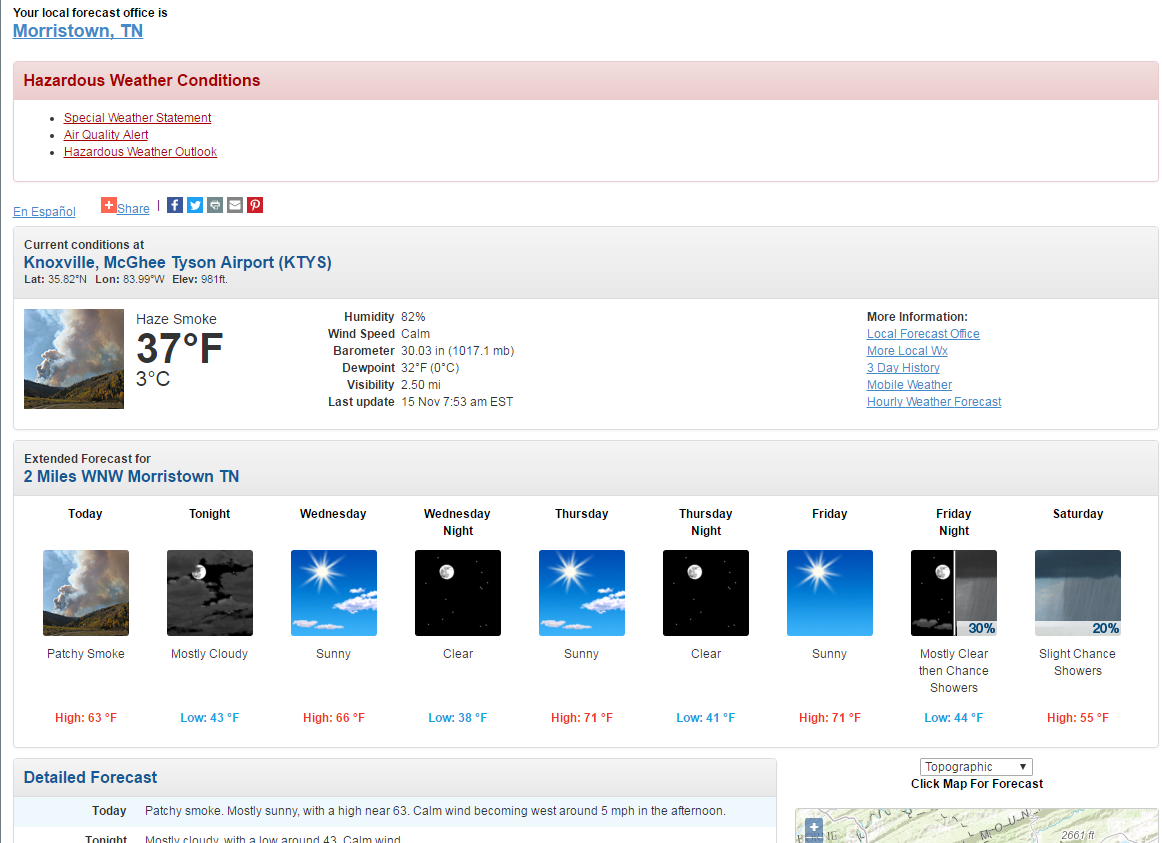

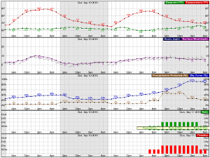
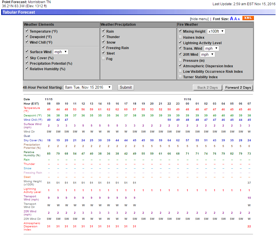
 Local Radar
 Huntsville Radar
 Regional Satellite
 Graphical Forecast
 Weather Map
 Daily Graphics
 Follow us on YouTube