Showers and thunderstorms capable of producing widespread heavy rainfall will be possible across much of Puerto Rico today. Heavy rainfall will likely lead to flash, urban and small stream flooding. Some areas may face life-threatening flooding. In the Southeast U.S., strong to marginally severe thunderstorms will be possible this afternoon. Read More >
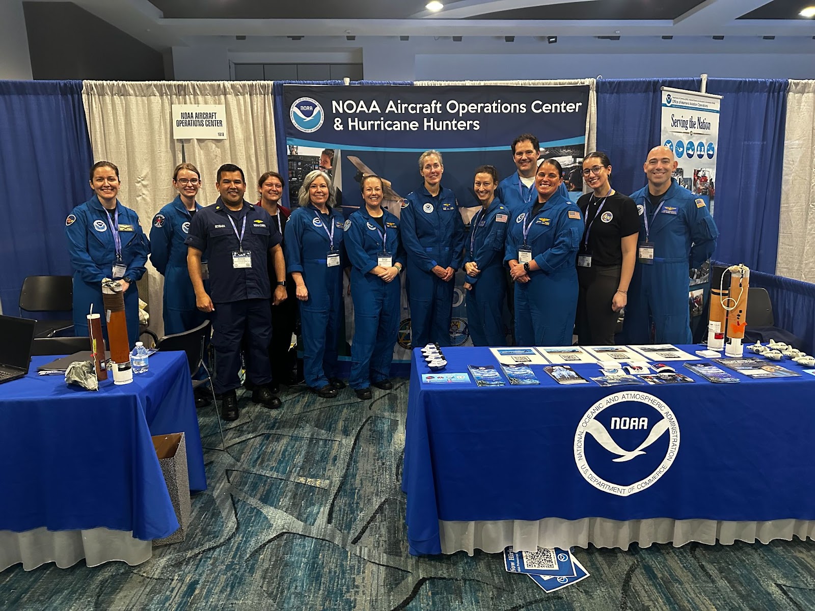
NOAA Aircraft Operations Center (AOC) members and Aviation Weather Center (AWC) senior meteorologist Brandy Bourque hosted a booth at the 35th annual Women in Aviation International conference held in Orlando, FL. The conference was officially from March 21st-23rd, but for those interested a tour of the AOC facility in Lakeland Linder International Airport in Lakeland, FL was held on March 20th. The tour generated a lot of interest from attendees as did the speech given during one of the general sessions by Rear Admiral Nancy Haan, Director of the NOAA Office of Marine and Aviation Operations and director of NOAA Commissioned Officer Corps. The AOC/AWC booth was busy throughout the conference addressing many job opportunity inquiries, career path discussions, and feedback on the AWC website that was redesigned and made more mobile friendly in the past year.
The majority of attendees were pilots or student pilots, but others were aircraft mechanics, instructors, various military personnel, budget analysts, and others all in the field of aviation. The conference’s goal is to bring women working in all aspects of aviation together to make connections, share opportunities, learn from each other, and encourage and support one another in their careers and various journeys in the aviation field. This was one of the largest conferences held to date with over 5,200 attendees including 142 international representatives from 35 countries; there were also more than 130 scholarship recipients. Inductees into WAI’s International Pioneer Hall of Fame included Katherine Johnson, the U.S. Air Force First Undergraduate Navigator Class, and the U.S. Army Air Forces World War II Flight Nurses. Next year’s annual WAI conference will be held in Denver, Colorado March 27-29.
NWS Aviation Weather Center and NOAA AMAO team up at Women in Aviation International in Orlando, FL
FAA’s SWAP (Severe Weather Action Plan) season began this March, and meteorologists from the National Weather Service and stakeholder organizations servicing commercial and private aviation have begun formal collaborations forecasting convection across the country. These collaborative forecasting sessions produce the Traffic Flow Management Convective Forecast or TCF.
Convective activity is responsible for a great number of delays and deviations across the National Airspace System (NAS). Aside from threats of lightning and hail, convective activity resulting in thunderstorms presents many other dangerous hazards, such as turbulence, icing, erratic winds, downdrafts, and updrafts. Any thunderstorm, regardless of a specific hazard or threshold, poses a threat to pilots and is therefore avoided. While any meteorologist will tell you that convection occurs any time of year, the FAA has recognized that the bulk of hazards occur during the warm season and its transitions from March 1 through October 31.
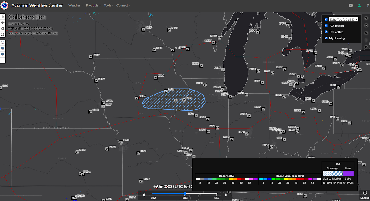
During the eight months of SWAP, specially-trained TCF meteorologists at the Aviation Weather Center (AWC) in Kansas City monitor convection and its potential across the NAS. These meteorologists produce preliminary forecasts of convection depicting density, timing, and echo top heights. Collaborators such as Center Weather Service Unit (CWSU) meteorologists, National Aviation Meteorologists (NAMs) at the FAA Command Center in Warrenton, Virginia, Meteorological Services of Canada meteorologists, as well as industry meteorologists for airlines and air cargo review the preliminary forecasts. Using critical analysis of radar and satellite data, surface operations, model projections, as well as their own expertise, participants expound ideas on convective evolution to finalize a four, six, and eight-hour forecast for the TCF. They use a drawing tool, referred to as the whiteboard, to propose different ideas on convective activity genesis, tops, spatial density, placement, movement, and dissipation. Whiteboard participants can draw edits directly on the map or even propose removal of features. The task is not easy as convection is still one of the most challenging physical processes that numerical models predict. When asked about the hardest part of the job, Hilary Clarin, meteorologist with CWSU Fort Worth stated, “...low confidence weather delays where there isn’t really any model agreement amongst the position/impact of expected convected activity.” Meteorologists often must outsmart models with their own expertise, keen awareness of current conditions, identification of triggering features, and deep conceptual understanding.
While always respectful, at times passion is not easy to miss. Participants are encouraged to present cases with sound meteorological reasoning to support their arguments. A single great idea with well-conceived reasoning can potentially change the entire forecast. In many ways, it is like a parliamentary procedure with the AWC TCF Meteorologist as the “plus-one” or deciding vote. When asked what he appreciates about the TCF product, Chris Duke, an AWC Senior Aviation Meteorologist, says, “Definitely the collaborative process. After analysis of a given forecast, we each give our own input which results in a thorough, well-thought out, collaborative forecast that is representative of the whole unit.” Sean Campbell, another Senior Aviation Meteorologist with experience at CWSU Washington and the AWC adds, “I appreciate the different perspectives that everyone involved in the TCF collaboration process brings, as they help me learn and improve my own forecasting skills.” Importantly, the resulting collaborated TCF product provides the FAA a harmonized and collective meteorological forecast, which they can use with confidence for management of the NAS with efficiency and safety in mind.
It doesn’t stop there. At FAA regional air traffic control centers across the country and the FAA Command Center in Virginia, NWS meteorologists provide further insight on the convective evolution above and beyond what the TCF communicates. Individual meteorologists are responsible for describing the evolution of current convection as it morphs into the four-hour TCF. This communication is aided by the traditional embedded nature of NWS’s DSS with the FAA. As an NWS aviation meteorologist, briefings are not given to someone you’ve never met before, but to those you park next to, share funny stories with, and give a hard time when their team plays yours. Air traffic specialists also know the cadence of your words when you lack confidence and how you have phrased the weather in the past and what happened then. Meteorologist Andrea LaRocca from CWSU Boston understands the impact of communication style to her embedded partners. When it comes to convection, she ensures she communicates information to their preference. “They usually prefer a worst case scenario to plan for, than be blindsided by an underforecast event that leaves us all scrambling,” states La Rocca. She adds that the Boston airspace’s proximity to the New York market and the complexities that arise from that is key. Jenn Daniel from CWSU Fort Worth strives to recognize those little nuances that make each day different. “Stay humble to Mother Nature and listen closely to what she's telling you every single day. This is how I keep myself from becoming biased for the TCF.” It is Decision Support Service at the deepest level. While just one of many responsibilities of the NWS network of aviation meteorologists, it is one of the most important. To illustrate its success, the FAA and NWS have showcased the TCF collaborative process to international organizations providing similar services.
Have a passion for aviation? Enjoy interactive communication? Relish the ability to watch your forecast be used for decisions before your very eyes? The NWS AWC in Kansas City, Missouri, and CWSUs across the country have openings. Dynamic, fast-paced, and expressive meteorologists are encouraged to apply.
Collaboration whiteboard for the 6-hour forecast of the 21Z TCF on March 29, 2024, profiling the development of sparse convection over western Chicago Center at 03Z from a passing shortwave across the Upper Mississippi Valley (northwestern Illinois and eastern Iowa). Participants on this session included meteorologists from the Aviation Weather Center in Kansas City, MO, and Warrenton, VA; CWSUs Chicago, Kansas City, Jacksonville; Fort Worth, Houston, Minneapolis, Memphis, Atlanta, Miami, and Los Angeles; and FedEx.
EMC Verification System (EVS) v1 in Operations
National Weather Service Central Operations (NCO) implemented version 1 of the Environmental Modeling Center Verification System (EVS) real-time software system that provides verification statistics and graphics for NCEP operational forecast systems on March 26, 2024. Using the Developmental Testbed Center’s (DTC) Model Evaluation Toolkit (METplus) suite of verification software, the EVS uses both real-time forecast output and environmental observations to create information on the performance of all NCEP environmental models and products, which are either derived or directly created from the Unified Forecast System (UFS) suite of models. The EVS generates hundreds of metrics for the suite, which when viewed on EMC webpages will provide a comprehensive and up-to-date overview of the performance of NCEP forecast systems for the general public, model developers, researchers, and decision makers. As EMC works with the international modeling community to develop modeling systems that are based on the Unified Forecast System (UFS), EMC is now evolving towards using the EVS for a single, unified verification software system for real-time verification analysis, evaluation of new and upgraded systems proposed for NWS operations, and as a capability to determine systematic errors and biases that illustrate areas for potential model improvements. This project, led by EMC’s Verification, Post-Processing, and Product Generation Branch (VPPPGB) aims to unify EMC’s verification strategy under one maintainable and supportable software system, and to use performance metrics that have been vetted and peer-reviewed by the UFS community via the Developmental Testbed Center’s 2021 UFS Metrics Workshop. Real-time images from the EVS can be found at: https://emc.ncep.noaa.gov/users/verification/.