
Isolated strong to severe thunderstorms capable of producing large hail and damaging wind gusts will be possible this evening across west-central Texas. Elevated to Critical fire weather conditions will persist across the southern Rockies and portions of the southern Plains through this weekend. Read More >
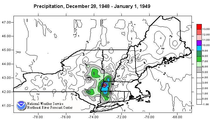
Rain with warming temperatures started on December 28, 1948 as a result of a low pressure
system moving into New England from the southwest. As the system was blocked by high
pressure over the North Atlantic, the system stalled. Over the next several days, over 5 inches of
rain fell, primarily over the Housatonic and Hudson River basins. The peak accumulations, just
over 13 inches, fell in the Berkshires, in western Massachusetts. Only during the last 24 hours of
the event, which ended on January 1, did the rain turn into snow.
Most of the streams and rivers started to crested on either New Years Eve or New Years Day.
While there was some snow on the ground at the beginning of the event, the major portion of the
runoff was from the rain.
Record breaking peaks occurred at several locations within the Hudson and Housatonic
drainages. Flooding also occurred in some of the western tributaries to the Connecticut River.
The flood on the lower Hudson was reduced somewhat by the controls at Sacandaga Lake, which
held all inflow beginning on the morning of December 31. The result was that the record
breaking floods above the reservoir, did not result in record breaking flows below the dam.
Total damages from the flooding were estimated to be approximately 10 million dollars. In
addtion, at least five lives were lost in Massachusetts and Connecticut.
| River | Location | Flow | cfs/sq mile | Stage |
|---|---|---|---|---|
| Connecticut | Thompsonville | 138,000 cfs | 14 csm | 9.30 ft |
| Deerfield | Charlemont | 42,600 cfs | 118 csm | 17.8 ft |
| Housatonic | Gt Barrington | 12,200 cfs | 43 csm | 12.1 ft * |
| Housatonic | Gaylordsville | 32,300 cfs | 32 csm | 14.9 ft |
| Hudson | North Creek | 28,900 cfs | 36 csm | 12.1 ft * |
| Hoosic | Eagle Bridge | 55,400 cfs | 108 csm | 21.1 ft * |
| Hudson | Green Island | 181,000 cfs | 22 csm | 27.1 ft |

