
Isolated strong to severe thunderstorms capable of producing large hail and damaging wind gusts will be possible this evening across west-central Texas. Elevated to Critical fire weather conditions will persist across the southern Rockies and portions of the southern Plains through this weekend. Read More >
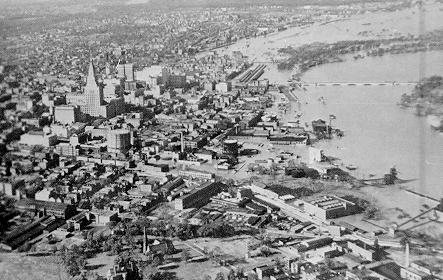
Hartford, Connecticut
When New Englanders think of September 1938, what comes to mind is the great hurricane that struck. It certainly was a major hurricane, producing winds over 100 mph from New London to Fall River and causing a massive amount of wind damage. In addition, the storm produced major flooding, much of the flooding occurring in the same areas that had record breaking flooding only two years prior.
The initial cause of the flooding was not however the hurricane. The rains produced with the hurricane took a minor or moderate flood and resulted in the major flooding that occurred in 1938. Rainfall of over an inch occurred on both September 12 and September 15. This did not cause any significant flooding, but it did cause a significant rise in river levels, groundwater levels, and soil moisture. The stage was set. On September 17-20, a large storm produced large areas of more than 6 inch rainfall. This rainfall was sufficient to produce flooding, particularly over many tributary rivers throughout New England.
This was followed by the hurricane on September 21 which again produced widespread areas of 6 inch rainfall. The area of maximum precipitation for the entire 5 day period fell over the Thames River basin in eastern Connecticut where areas of over 13 inches of rainfall were recorded. Isolated reports of over 17 inches were also received. The Quinnebaug River in the Thames drainage was particularly hard hit. Many of the tributary rivers to the Connecticut River also saw record flows, notably on the Deerfield, Millers, and Chicopee. The resultant flow on the Connecticut, although not as high as recorded in 1936, produced major flooding. The table below shows a selection of areas that were particularly hard hit during the 1938 storm.
The combination of the floods and hurricane resulted in the loss of approximately 600 lives. Property damage was estimated to exceed 400 million dollars.
| River | Location | Flow | cfs/sq mile | Stage |
|---|---|---|---|---|
| Merrimack | Lowell | 121,000 cfs | 26.1 csm | |
| Contoocook | Penacook | 42,400 cfs | 55 csm | |
| Shetucket | Willimantic | 52,200 cfs | 129 csm | 27.6 ft |
| Quinnebaug | Baltic | 77,700 cfs | 61 csm | |
| Deerfield | Charlemont | 56,300 cfs | 156 csm | 20.2 ft * |
| Connecticut | Thompsonville | 236,000 cfs | 14.4 ft | |
| Connecticut | Hartford | 232,000 cfs | 35.4 ft | |
| Farmington | Tariffville | 29,900 cfs | 52 csm | 14.0 ft |
| Millers | Erving | 29,000 cfs | 78 csm | 13.4 ft * |
Note: * represents flood of record

