
Strong to severe thunderstorms capable of damaging wind gusts, large hail, and perhaps a couple tornadoes, are likely Thursday from parts of the lower Ohio Valley into the southern Plains. An Enhanced Risk (Level 3 of 5) outlook has been issued. Further north, a warm front will bring areas of rain showers to portions of the Great Lakes and Northeast U.S. Read More >
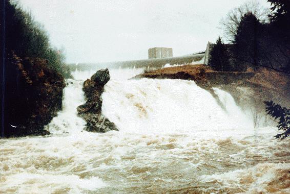 |
| Knightville Dam, Westfield River, Huntington, Massachusetts |
A pair of spring storms occurring in March and April 1987 combined with snowmelt to produce record or major flooding Maine, New Hampshire, and Massachusetts. Fortunately, the heaviest rains for the two storms did not fall over the same area or else more hazardous flooding could have occurred.
February and March had generally been clear and dry. In the days prior to the first storm, temperatures throughout New England had generally been in the 50s and lower 60s. The result was that in southern New England, much of the snowpack from December and January had disappeared except in the higher hills. In Maine however, fairly significant snowpacks were still present in many area and the warming temperatures had produced a snowpack ripe for melting. Five to 6 inch snow water equivalents were not uncommon, with some measurements still of 10 inches being recorded at the end of March.
A storm that had lashed the midwest with heavy snow and winds over the midwest United States spun off a slow moving low pressure system that moved across New England. The southeasterly winds produced significant orographic enhancement in the mountains of Maine and New Hampshire significantly increasing the precipitation totals on the east side of these mountain ridges. The highest rainfall accumulations recorded were 8.30 inches at Pinkham Notch, New Hampshire, and 7.3 inches at Blanchard Maine.
The results of this first storm were mainly focused on Maine. The Kennebec River basin was most severely impacted with record flows on the mainstem and its primary tributaries -- the Carrabassett, Sandy, and Sebasticook. The Piscataquis River experienced flows 50% greater than any measured before. Many other rivers in Maine -- Penobscot, Saco, and Androscoggin -- all suffered significant flooding; however, flows were generally below records that had occurred earlier in the century. Total damages in Maine from this first storm were estimated at 74.5 million dollars. Amazingly, only one flood related death was known to occur. In addition to the major flooding in Maine, moderate flooding also occurred within the Merrimack River basin as well the Connecticut River basin
The second storm, following only a few days after the rains from the first storm ended, missed Maine, but delivered tremendous amounts of rain to New Hampshire and Massachusetts. Generally 4 to 7 inch rains occurred over much of this area. Amonts over 8 inches were recorded at stations in northwest Massachusetts as well as along the northeast Massachusetts coast. This rainfall, combined with the already high river conditions caused by the previous storms, produced major flooding in both the Connecticut and Merrimack River basins. However, recorded stages were generally less than those recorded during one or two of the larger events this century. In addition, several of the Corps of Engineers dams recorded record pool levels, even including uncontrolled spillway flood at six locations.
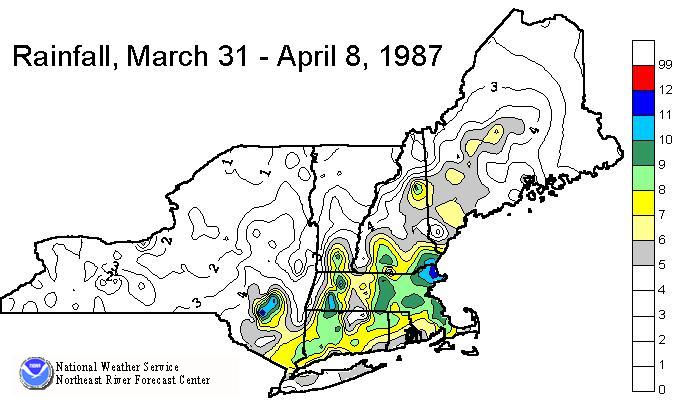 |
| Rainfall totals from March 31, 1987 through April 8, 1987. |
| River | Location | Flow | cfs/sq mile | Stage |
|---|---|---|---|---|
| Piscataquis | Dover-Foxcroft | 33,000 cfs | 111 csm | 22.6 ft * |
| Penobscot | Eddington | 153,000 cfs | 20 csm | 23.6 ft * |
| Kennebec | North Sidney | 222,000 cfs | 41 csm | 39.4 ft * |
| Carrabassett | North Anson | 41,000 cfs | 116 csm | 25.9 ft * |
| Androscoggin | Auburn | 102,000 cfs | 31 csm | 23.7 ft |
| Saco | Conway | 43,000 cfs | 112 csm | 17.1 ft |
| Pemigewasset | Plymouth | 48,100 cfs | 77 csm | 23.4 ft |
| Concord | Lowell | 5410 cfs | 18 csm | 9.6 ft * |
| Merrimack | Lowell | 84,700 cfs | 19 csm | 57.2 ft * |
| Ipswich | Ipswich | 3550 cfs | 27 csm | 9.4 ft * |
| Deerfield | W Deerfield | 61,700 cfs | 111 csm | 17.7 ft * |
| North | Shattuckville | 15,300 cfs | 172 csm | 11.2 ft * |
| Connecticut | Montague | 126,000 cfs | 16 csm | 35.9 ft |
Note: * represents a record flood at this location

