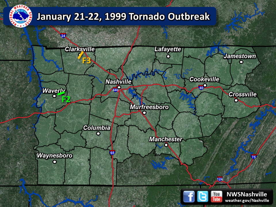
| Tornado Statistics | ||||||||
| # | Counties | Rating | Time (CST) | Length (miles) | Width (yards) | Fatalities | Injuries | |
| 1 | Montgomery | F3 | 0418 | 6.0 | 880 | 0 | 5 | |
| 2 | Humphreys | F2 | 0443 | 4.0 | 220 | 0 | 1 | |
| Overview | |
| A powerful storm system brought an unusually large winter tornado outbreak to Arkansas and surrounding states during the afternoon and evening hours on January 21, 1999. As this system spread eastward during the night, supercell thunderstorms moved from west Tennessee into Middle Tennessee, spawning at least two destructive tornadoes in Montgomery and Humphreys Counties. |
| Reports & Data | ||
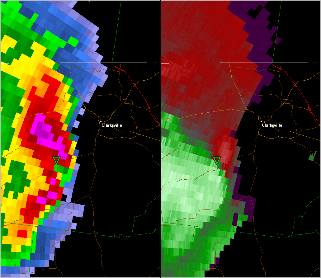
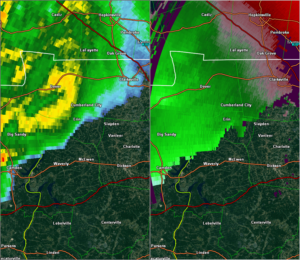
| SPC Storm Reports | SPC Event Archive | OHX Radar Loop - Clarksville Tornado |
| January 1999 Storm Data | GIS Damage Report by CMCGIS | OHX Radar Loop 3-5 AM CST |
| F3 Clarksville Tornado | |
| Counties: | Montgomery |
| Time: | 4:18 AM CST |
| EF Scale: | F3 |
| Damage Path Length: | 6 miles |
| Damage Path Width: | 880 yards |
| Fatalities: | 0 |
| Injuries | 5 |
| Damage: STORM DATA: An F3 tornado struck Clarksville at 415 AM, travelled through the downtown area and dissipated near St. Bethlehem. There were 5 injuries, 2 of them were for broken bones. Clarksville has a population of 89,000 people is Tennessee's fifth largest city. 25,000 people were without power. The Tornado Warning was issued by the NWS at 354 AM CST. The NOAA Weather Radio alerted the sleepy resident s of Clarksville and urge them to take cover immediately. The tornado ripped apart a 5 block area of downtown Clarksville and teared up buildings in Austin Peay State University. Once the tornado ravaged the city, downtown Clarksville resembled bombed-out London during World War 2. Bricks and glass were strewn everywhere. The photo editor of the Leaf-Chronicle newspapers, Fred Dye, said "It looked like somebody walked through with a broom and knocked over whatever was loose enough to knock down." The Montgomery county court house was in ruins. The City Fathers planned on rebuilding the court house. It was last rebuilt after a fire in 1878. The Leaf-Chronicle newspaper office was severely damaged. The newspaper had to set up a temporary office in Hopkinsville, KY. 22 buildings were heavily damaged at Austin Peay State University. Also, several old churches were heavily damaged in Clarksville. The Madison Street United Methodist Church lost its spires and roof. It will take about 2 years to rebuild the church. The Trinity Episcopal Church lost its roof. Police closed off downtown Clarksville from 6 PM-6 AM in order to prevent looting. The National Guard was on duty as well. On January 23, FEMA Director James Lee Whitt toured the devastation. He exclaimed, "Wow!" "It's like someone dropped a bomb on it. That's just what it look like." There was a total of 124 buildings destroyed and 562 buildings damaged. These figures included residential, commercial, government, public and buildings at Austin Peay. Damage totalled $72.7 million. SHAMBURGER (2015): NCDC incorrectly lists the path length, location and time of this tornado, which were corrected based on radar data and a GIS damage map created by Dr. McCluskey, Professor of Geography at Austin Peay State University. |
|
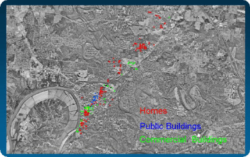 GIS map of damaged buildings in Clarksville
(by Dr. McCluskey, Austin Peay State University) |
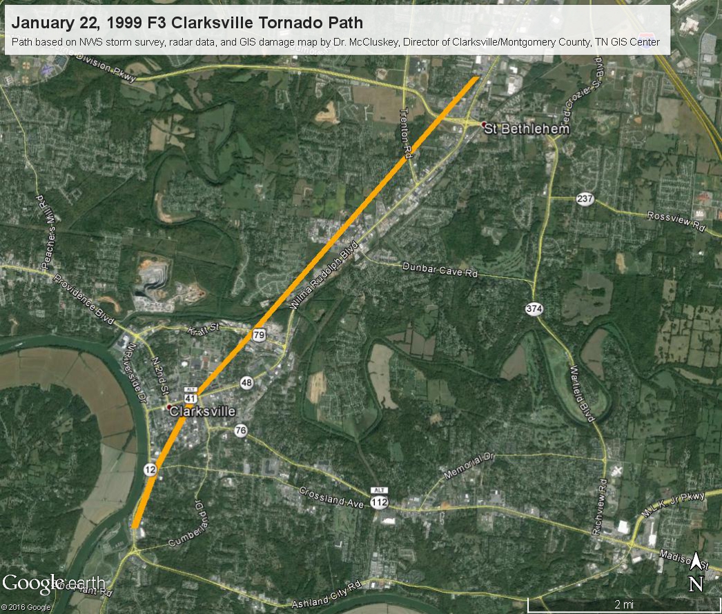 Map of Clarksville Tornado path
by NWS Nashville |
Photos: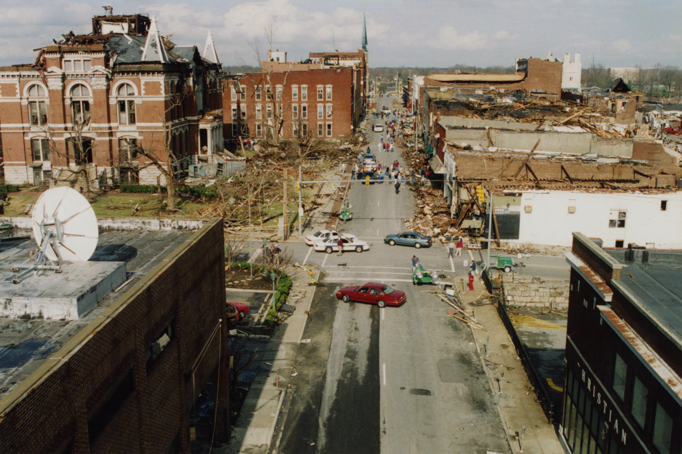 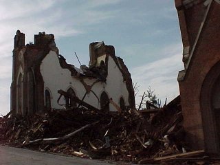 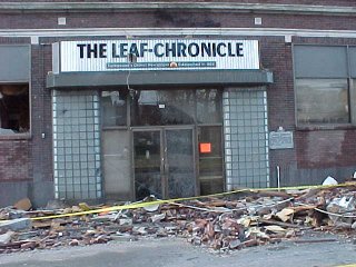 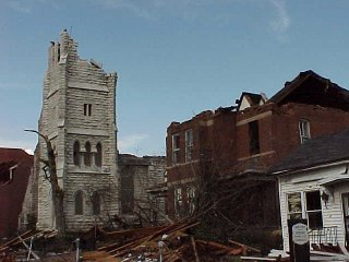 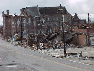 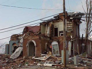 |
|
| F2 Humphreys County Tornado | |
| Counties: | Humphreys |
| Time: | 4:43 AM CST |
| EF Scale: | F2 |
| Damage Path Length: | 4.0 miles |
| Damage Path Width: | 220 yards |
| Fatalities: | 0 |
| Injuries | 1 |
| Damage: STORM DATA: Downed trees were reported from Gorman to McEwen. The hardest hit area was McEwen with 4 homes totally destroyed, 8 homes having severe damage, and 38 homes receiving minor damage. 8 to 10 outbuildings were destroyed and 60 trees were lost. 8 cars or trucks were damaged or destroyed. A man suffered a broken neck in his trailer. |
|


 Follow us on YouTube